Near Miss: Girdwood
Location: Virgin Creek – Big League
EVENTS
This account of the accident was paraphrased from multiple sources but is based on the initial observation located here.
A group of three backcountry skiers left the Virgin Creek trailhead in Girdwood Valley and toured up and over Max’s Mountain (also known as Baumann Bump) then down into Virgin Creek aiming to ski Big League (4423′ in elevation, also labeled Hibbs Pk on some maps). They noted that the weather was clear and warm with no wind. On their approach they could tell the had sun previously affected solar aspects but there was still dry soft snow on N to WNW aspects.
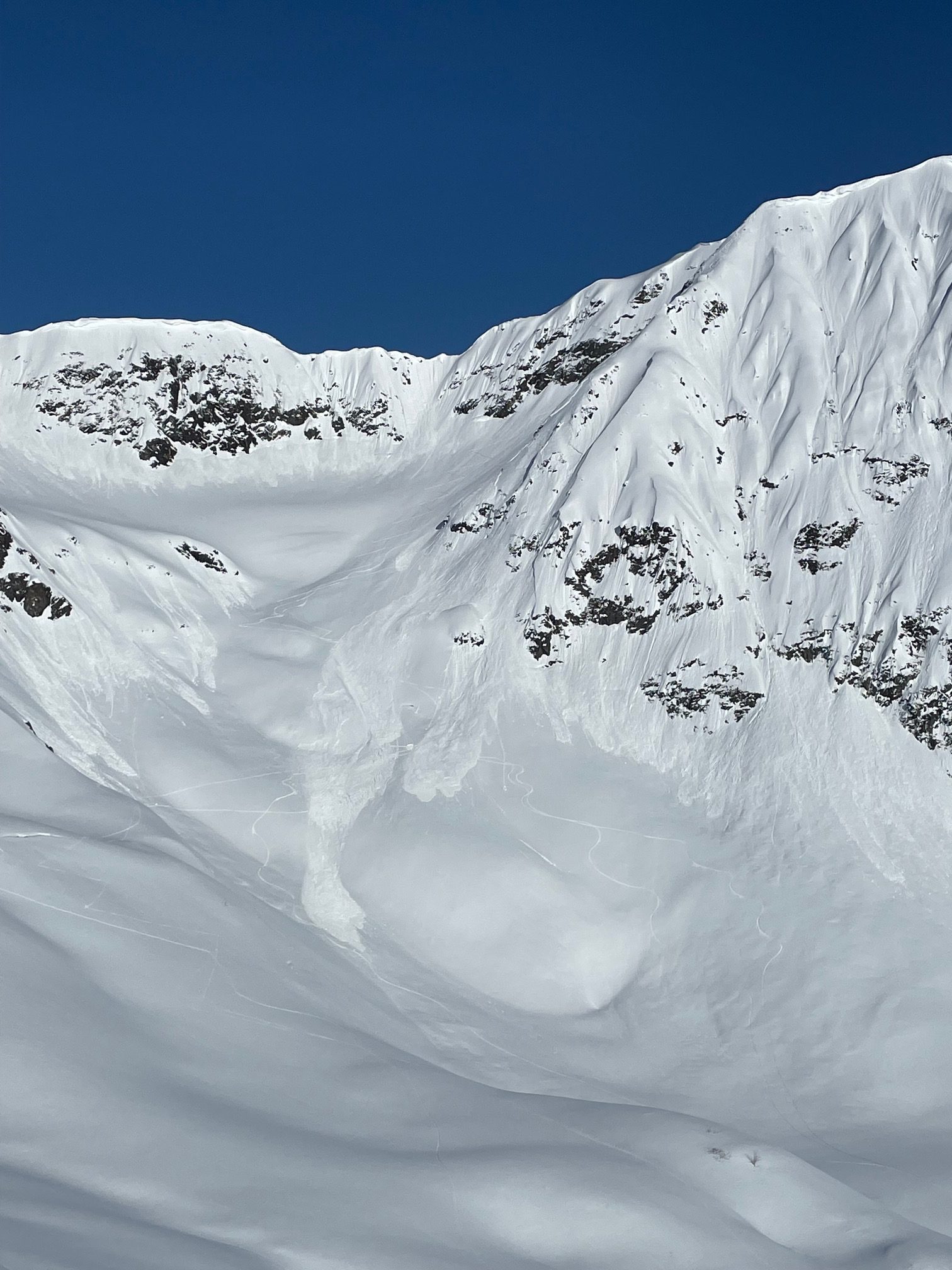
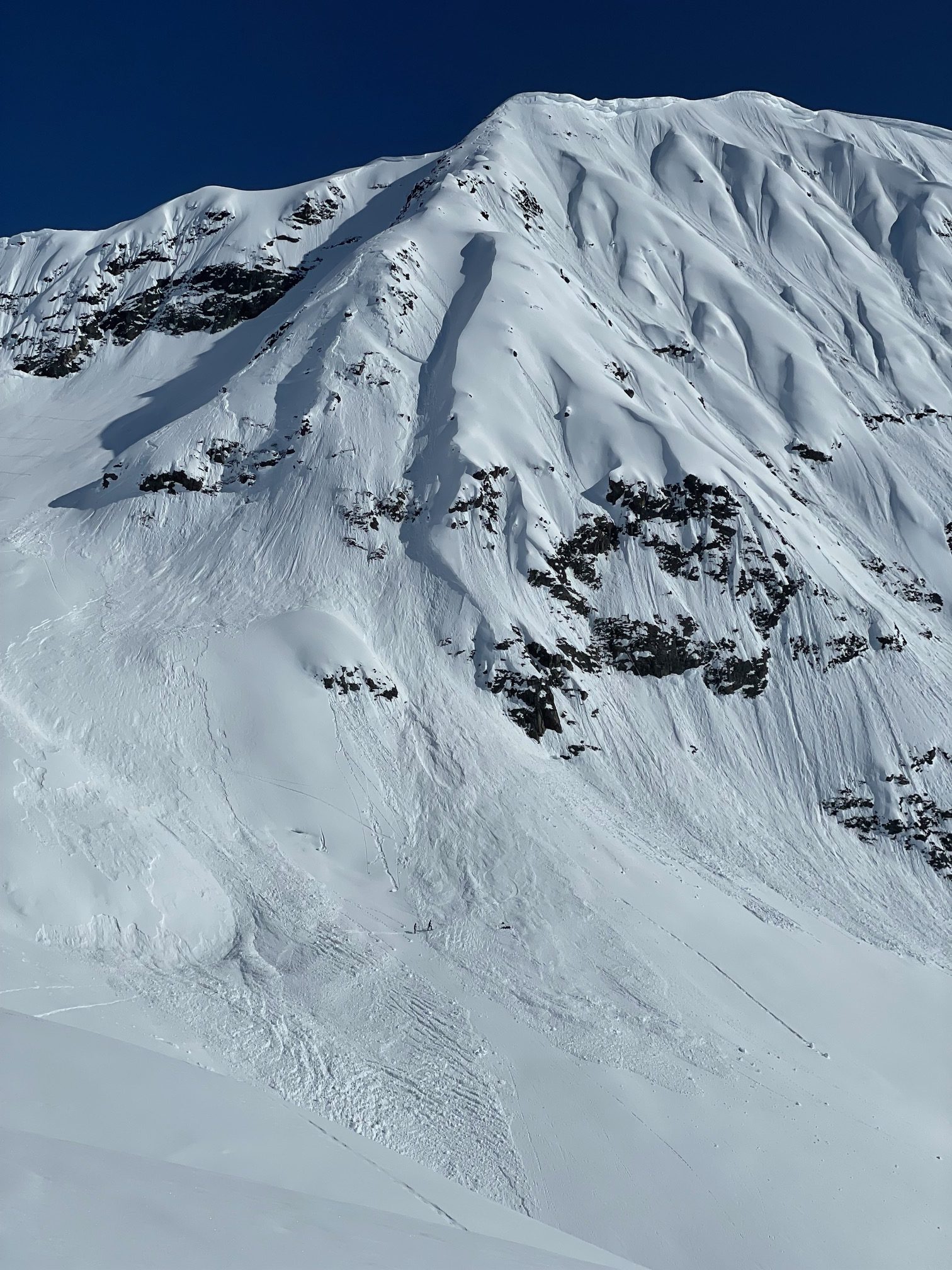
After considering alternative routes in the area, the group ultimately decided on skiing the northern most spine off of Big League as it had good coverage and excellent dry snow quality. They were aware of a recent skier triggered avalanche on Captains Chair, however were reassured by the lack of wind effect in the Virgin creek area, and the relatively isolated nature of the terrain feature they were planning on skiing. At around 3pm the first two skiers each skied down the NW facing spine, enjoying good snow with no evidence of instability. About halfway down, the third skier triggered a large slab avalanche. It released in the middle of the slope, 2-6′ deep and propagated 400’+ wide across multiple aspects. The skier was caught and fell over multiple cliff bands as he was carried by the debris.
The rest of the party spotting from below immediately lost sight of the skier after he triggered the slide. Once the debris stopped they quickly saw him partially buried near the toe of the debris and made verbal contact. Once he was partially excavated it was clear he had a femur fracture. Rescue services were contacted via 911 using a cell phone, but the group was also carrying a satellite communication device. After 1.5-2 hours the skier was airlifted by the Alaska Army National Guard to an Anchorage hospital. The group felt very fortunate that the caught skier escaped with only a femur fracture, as the accident could have easily proved fatal. They extend their thanks to a local Chugach Powder Guides guide who saw them while he was out for a personal ski day and came to render aid shortly after the avalanche.
In hindsight, the group feels like this was a spooky experience and they were overconfident in the stability of the snowpack despite knowing there were old deep persistent weak layers. They knew it had been several weeks since any avalanches had occurred in these old deep layers and had ‘begun to trust the snowpack’. One takeaway is that in years with persistent weak layers, the consequences of venturing into big and complex terrain should not be underestimated.
AVALANCHE INFORMATION
Type: Soft Slab
Problem/Character: Persistent Slab
Crown Thickness: 2-6′ (60-180 cm)
Width: 400 feet
Vertical Run: 1,500 feet
Trigger: Skier (unintentional)
Weak Layer: Suspected facets
Aspect: NW
Elevation: 3,600 feet
Slope Angle: 45 degrees
Code: HS-ASu-D2.5-R2-O
WEATHER AND SNOWPACK
A two week dry spell in the beginning of March facilitated development of a widespread weak layer. This included a layer of faceted snow on northerly aspects, which was capped by a crust on southerly slopes. The layer was buried during a weeklong series of storms starting March 14th, which brought 8.5-10′ low density snow equaling 6-7″ snow water equivalent (SWE). In the two weeks following the storm there were nearly 20 very large human triggered avalanches, with the last known skier-triggered avalanche on March 28, and the last documented avalanche triggered by a helicopter on March 30. All avalanches were releasing at the 3/14 interface.
Another dry spell during the end of March through early April brought about the development of another surface crust on southerly aspects, along with near-surface facets on isolated northerly slopes. From April 9-15 the weather station at the top of Chair 6 at Alyeska recorded 24″ snow equaling 2.4″ SWE, with the most intense precipitation between April 10-12. A handful of natural and human-triggered avalanches were observed during and immediately after the storm event, with the last known avalanches on April 10th releasing at the new/old snow (April 9) interface. The last pulse of moisture in this period added 4-6″ of snow on April 14th with moderate ridgetop winds. The following day skies cleared and a skier triggered a slab 8-12″ thick on the upper face of Captain’s Chair in Turnagain Pass (mentioned earlier in this report). It is worth noting that was a different type of avalanche, believed to be a wind slab involving the recent storm snow, which may have been sitting on a weak interface.
During the four days prior to the Big League avalanche, skies were partly to mostly cloudy with temperatures rising above freezing in the afternoons and below-freezing temperatures at night. The snow surface was warming enough to see multiple wet loose avalanches during this period, but avalanche activity was confined to east, south, and westerly slopes. From April 17-19, winds stayed below 10 mph on the nearby weather stations of Max’s Mountain and Alyeska Summit– roughly 1 mile west of the site of the incident.
The group suspected the weak layer to be the early March facets (3/14 interface). The nature of the terrain in which this avalanche occurred made it not feasible to do a crown investigation, which means we cannot know for certain which weak layer was the culprit. Based on the character of the avalanche, it is very likely that is was a buried persistent weak layer. The depth does suggest it could have been the 3/14 interface. With over three weeks of no activity on the 3/14 interface, the avalanche caught the group and the avalanche center by surprise. We had believed the layer to be unreactive until the snowpack warmed enough for liquid meltwater to start flowing through it. This turned out not to be the case as the snowpack was still dry and had not yet begun the springtime transition when these layers tend to become active again.
AVALANCHE DANGER
There was no official forecast on the day of the avalanche due to the end of season forecasting schedule being Tue, Thur, Sat, Sun. The forecast on Tuesday noted: “*WEDNESDAY AVALANCHE OUTLOOK: Look for an increase in wet loose avalanches due to warmer daytime temperatures forecast for Wednesday afternoon. In general however, avalanche conditions should remain similar to those on Tuesday and in the MODERATE category.”
An ‘Additional Concern’ for Deep Persistent Slab avalanches remained in the forecast stating:
“While the main avalanche concerns lie in the upper snowpack, there is still a suspect layer of rounding facets buried 3-6′ deep. This layer was responsible for many very large human triggered avalanches in the second half of March, but we have not seen any activity on it for three weeks. Although it would be very unlikely to trigger an avalanche this deep now, we are keeping it in the back of our minds, especially as the snowpack slowly warms. Once the snowpack starts seeing significant warming, we are anticipating some big wet slabs in the future.”
We would like to thank the skiers involved for sharing their information and photos.
Report compiled by Chugach NF Avalanche Center staff.
Contact: staff@chugachavalanche.org