Turnagain Pass RSS

Archives
ARCHIVED - Forecasts expire after 24 hours.
Issued
Sat, April 24th, 2021 - 7:00AM
Expires
Sun, April 25th, 2021 - 7:00AM
Forecaster
Wendy Wagner
Avalanche risk The Bottom Line

The avalanche danger is LOW this morning and expected to rise to CONSIDERABLE through the day as surface crusts melt and the snow loses strength on slopes seeing direct sunshine. Once surfaces melt and boot-top wet saturated snow exists, wet loose avalanches will be likely to trigger on slopes around 35 degrees or steeper. Natural wet loose and wet slab avalanches will be possible with the heat of the day as well. These avalanches have the potential to be large and dangerous. Pay close attention to surface conditions and how crusts melt. Avoid being under glide cracks and give cornices a wide berth.

CROW PASS, PORTAGE VALLEY: Natural avalanches are possible and could send debris over summer hiking trails and into the valleys during the afternoon and evening hours. Hiking on summer trails that pass through avalanche terrain is not recommended during these times this weekend.

Special Announcements

CNFAIC End Of Season Operations:  Daily avalanche forecasts have ended as our forecast season and funding winds down. We will forecast today, Sun, Tues, Thurs this week, and put out our springtime tips this coming weekend. We would be grateful for any observations as our field time has wound down as well – thank you!

Sat, April 24th, 2021
Alpine
Above 2,500'
3 - Considerable
Avalanche risk
Treeline
1,000'-2,500'
3 - Considerable
Avalanche risk
Below Treeline
Below 1,000'
3 - Considerable
Avalanche risk
0 - No Rating
1 - Low
2 - Moderate
3 - Considerable
4 - High
5 - Extreme
Avalanche risk Avalanche risk Avalanche risk Avalanche risk Avalanche risk
Travel Advice Generally safe avalanche conditions. Watch for unstable snow on isolated terrain features. Heightened avalanche conditions on specific terrain features. Evaluate snow and terrain carefully; identify features of concern. Dangerous avalanche conditions. Careful snowpack evaluation, cautious route-finding, and conservative decision-making essential. Very dangerous avalanche conditions. Travel in avalanche terrain not recommended. Extraordinarily dangerous avalanche conditions. Avoid all avalanche terrain.
Likelihood of Avalanches Natural and human-triggered avalanches unlikely. Natural avalanches unlikely; human-triggered avalanches possible. Natural avalanches possible; human-triggered avalanches likely. Natural avalanches likely; human-triggered avalanches very likely. Natural and human-triggered avalanches certain.
Avalanche Size and Distribution Small avalanches in isolated areas or extreme terrain. Small avalanches in specific areas; or large avalanches in isolated areas. Small avalanches in many areas; or large avalanches in specific areas; or very large avalanches in isolated areas. Large avalanches in many areas; or very large avalanches in specific areas. Very large avalanches in many areas.
Recent Avalanches

Over the past two days the mountains have been much quieter avalanche-wise. However, in the Summit Lake area south of the forecast zone two large natural wet slabs released on Butch Peak (likely 2 days ago on Thursday). Additionally, one human triggered wet sluff occurred in Lynx Creek yesterday (Friday).

One of two large wet slab natural avalanches in the Summit Lake area (Butch Peak, SW facing). These are believed to have released sometime Thursday 4.22 afternoon. Photo taken 4.23.21 by Alex McLain.

Wet loose avalanche triggered by a snowboarder on a thin steep rocky feature. Avalanche was small, but took the all the snow (2′ or so) that existed on this feature. Note that the other avalanche debris and roller balls are old – likely from a week ago. 4.23.21.

Avalanche Problem 1
  • Wet Loose
    Wet Loose
  • Certain
    Very Likely
    Likely
    Possible
    Unlikely
    Likelihood
  • Historic (D4-5)
    Very Large (D3)
    Large (D2)
    Small (D1)
    Size
Wet Loose
Wet Loose avalanches are the release of wet unconsolidated snow or slush. These avalanches typically occur within layers of wet snow near the surface of the snowpack, but they may quickly gouge into lower snowpack layers. Like Loose Dry Avalanches, they start at a point and entrain snow as they move downhill, forming a fan-shaped avalanche. Other names for loose-wet avalanches include point-release avalanches or sluffs. Loose Wet avalanches can trigger slab avalanches that break into deeper snow layers.

Likelihood of Avalanches
Terms such as "unlikely", "likely", and "certain" are used to define the scale, with the chance of triggering or observing avalanches increasing as we move up the scale. For our purposes, "Unlikely" means that few avalanches could be triggered in avalanche terrain and natural avalanches are not expected. "Certain" means that humans will be able to trigger avalanches on many slopes, and natural avalanches are expected.

Size of Avalanches
Avalanche size is defined by the largest potential avalanche, or expected range of sizes related to the problem in question. Assigned size is a qualitative estimate based on the destructive classification system and requires specialists to estimate the harm avalanches may cause to hypothetical objects located in the avalanche track (AAA 2016, CAA 2014). Under this schema, "Small" avalanches are not large enough to bury humans and are relatively harmless unless they carry people over cliffs or through trees or rocks. Moving up the scale, avalanches become "Large" enough to bury, injure, or kill people. "Very Large" avalanches may bury or destroy vehicles or houses, and "Historic" avalanches are massive events capable of altering the landscape.

Signal Word Size (D scale) Simple Descriptor
Small 1 Unlikely to bury a person
Large 2 Can bury a person
Very Large 3 Can destroy a house
Historic 4 & 5 Can destroy part or all of a village
More info at Avalanche.org

Triggering a wet loose avalanche is likely on steep slopes that have softened enough to harbor boot-top (or deeper) wet surface snow. These ‘sluffs’ could be small or large pending the size of the terrain. They could gouge down and take the whole snowpack if the conditions are right and especially if the snowpack is thinner. These types of avalanches are nothing to mess with and can be quite destructive. Wet slabs on slopes seeing significant warming will be possible to trigger and can be extremely destructive. They can, and often are, triggered by a wet loose avalanche. Wet slabs are most likely to occur in areas with a thinner snowpack, such as Summit Lake. Although natural wet loose and wet slab avalanches will be possible today, it’s the human triggered avalanches that will be likely. Hence the danger rising to CONSIDERABLE in step with daytime warming and sunshine.

Timing is everything… The goal for a fun day in the mountains is to catch the surface when it’s melted a few inches but not so much that your boot or snowmachine track is sinking way down into 10+” of mush. At this point, it’s time to head to another aspect. As we know, north and east aspects warm first, then south, then west, and last north gets the sun again this time of year. Paying close attention to how much wet snow exists on the slopes you encounter is key. Exit routes require thought as well. We don’t want to be forced into traveling under steep rocky terrain baking in the sun that could shed snow onto us.

Cornices: These features are oozing over in the warm temperatures and will become easier and easier to trigger as time goes on. Be aware to not accidentally travel onto one and limit any exposure under them.

After 8 days of unseasonably warm springtime temperatures bringing down the house, it looks as though the mountains are starting to adjust to the spring transition. In case you missed it, here’s a little video of the widespread natural avalanche cycle that occurred last weekend. Since then, we’ve seen a handful of natural glide avalanches, wet loose and wet slab avalanches. Most of the wet slabs are being seen in areas with a thinner snowpack, such as the Summit Lake area in the photo above. As we move forward, we are not out of the woods. Remember, large natural avalanches are still possible and human triggered avalanches likely. These could be significant enough to run into valley bottoms in areas with enough snow left on the mountainsides.


Playing the aspects for fun soft snow, but safe avalanche conditions. 2.23.21.

A big thank you to APU’s snow science course for not only assessing the corn skiing conditions on Sunburst yesterday, but for providing snowpack information throughout the season! See their pictures and comments below.

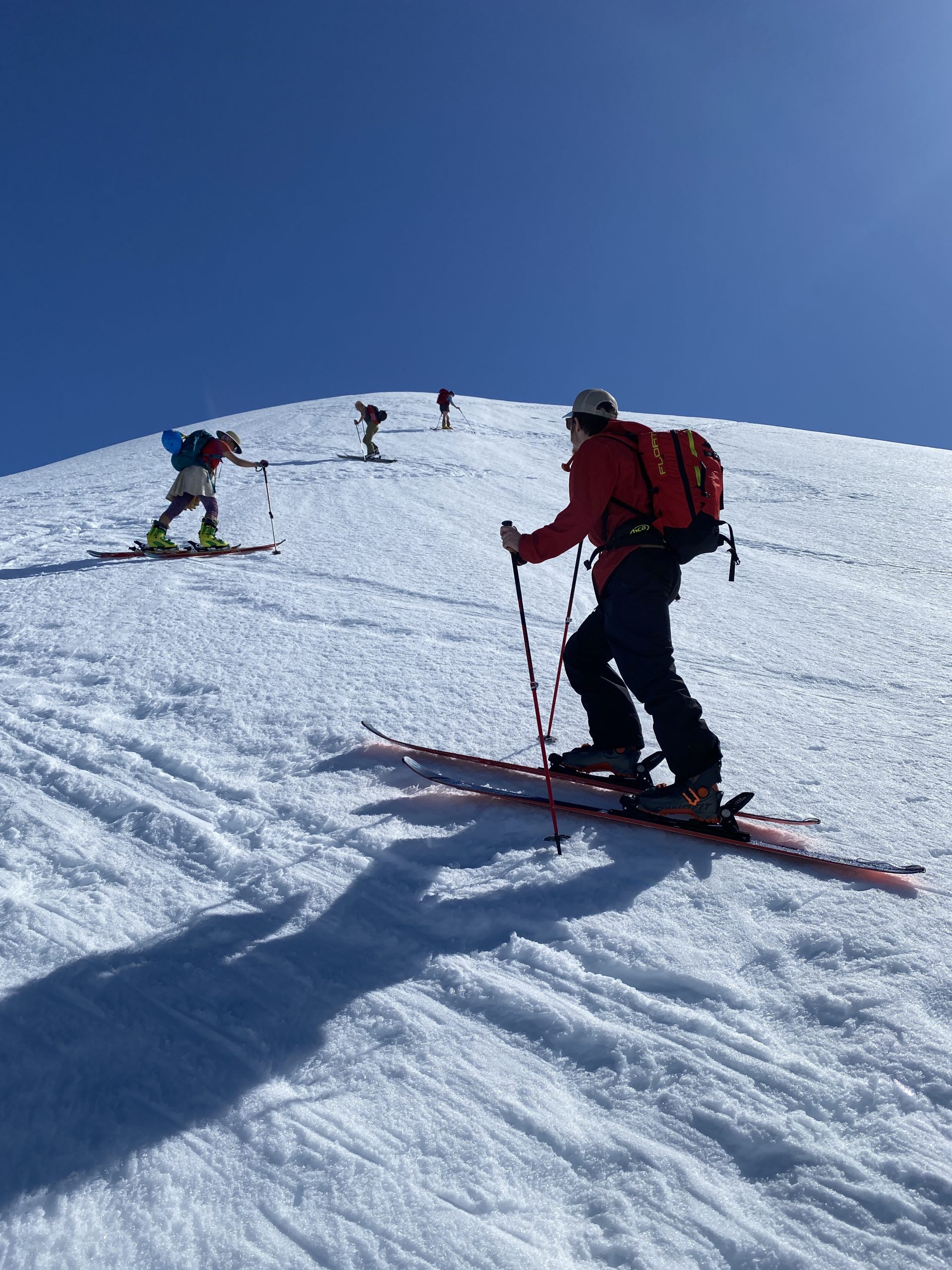
“Tricky skinning along the Sunburst lower ridge line. While during our tour avalanche hazard was low, sliding hazard was imminent. Time to think about self arrest skills, Whippet and potentially ski crampons!” 4.23.21. Eeva Latosuo.


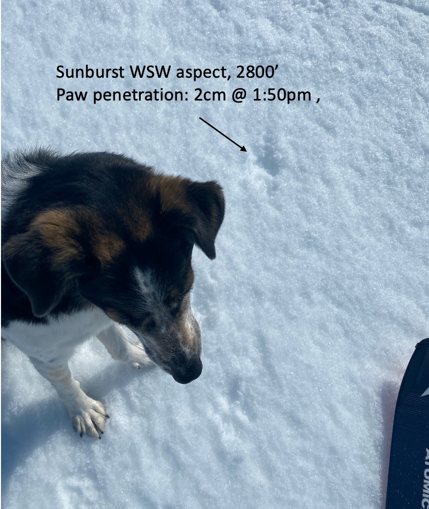
“By 1:30pm surfaces started to soften up quite nicely as exemplified here: 2 cm paw penetration by 30lbs canine.” 4.23.21. Eeva Latosuo.
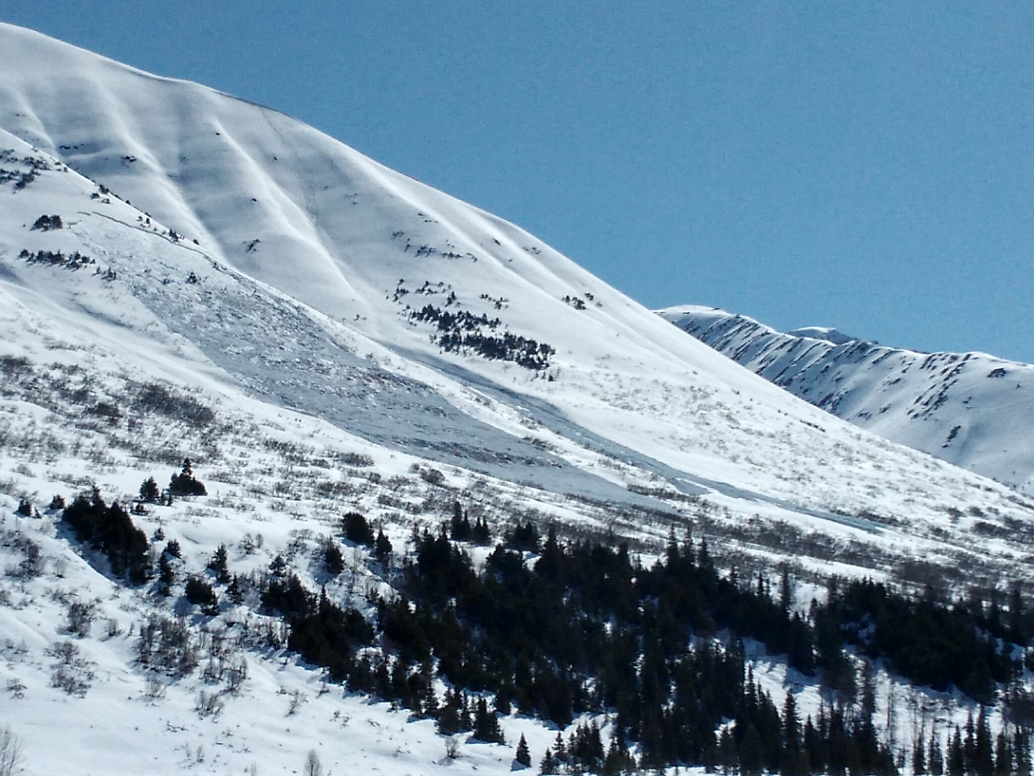
Additional Concern
  • Glide Avalanches
    Glide Avalanches
Glide Avalanches
Glide Avalanches are the release of the entire snow cover as a result of gliding over the ground. Glide avalanches can be composed of wet, moist, or almost entirely dry snow. They typically occur in very specific paths, where the slope is steep enough and the ground surface is relatively smooth. They are often proceeded by full depth cracks (glide cracks), though the time between the appearance of a crack and an avalanche can vary between seconds and months. Glide avalanches are unlikely to be triggered by a person, are nearly impossible to forecast, and thus pose a hazard that is extremely difficult to manage.
More info at Avalanche.org

Glide avalanches are releasing as the entire snowpack warms up. This is the time to not trust any glide cracks and limit/avoid time under them. They are opening up and releasing around the region, including easily accessed areas such as the front side of Seattle Ridge.

Bears:  In all seriousness, bears are waking up and folks have been seeing them roaming about. It’s a good thing we are trained to observe natural hazards and now we can add bears to the list.

Weather
Sat, April 24th, 2021

Yesterday:  Sunny skies with light easterly ridgetop winds were over the region. Temperatures warmed to the the low 40’sF along the higher peaks and between 55-60F in the lower and mid elevations.

Today:  Another round of sunshine, light south to easterly ridgetop winds, and warm springtime temperatures is forecast. Overnight lows, last night, were in the 25-35F range in valley bottoms and in the 35-40F range in the mid and upper elevations. Daytime highs should be near 60F in the low elevations today and in the high 40’s F along the high ridgelines.

Tomorrow:  Continued sunny skies and light east winds are expected until early next week as the blocking high pressure remains entrenched over Southcentral. Temperatures are expected to continue to drop into the 25-35F range overnight with clear skies in valley bottoms and increase through the day to near 60F in the low elevations and to the high 40’s F in the high elevations.

PRECIPITATION 24-hour data (6am – 6am)

Temp Avg (F) Snow (in) Water (in) Snow Depth (in)
Center Ridge (1880′) 43 0 0 96
Summit Lake (1400′) 40 0 0 32
Alyeska Mid (1700′) 45 0 0 108

RIDGETOP 24-hour data (6am – 6am)

Temp Avg (F) Wind Dir Wind Avg (mph) Wind Gust (mph)
Sunburst (3812′) 39 NE 8 20
Seattle Ridge (2400′) 43 SE 4 10
Observations
Recent Observations for Turnagain Pass
Date Region Location
04/21/24 Turnagain Observation: Bertha Creek
04/20/24 Turnagain Avalanche: Spokane Creek
04/16/24 Turnagain Observation: Cornbiscuit
04/15/24 Turnagain Observation: Taylor Pass
04/15/24 Turnagain Observation: Seward Highway – Tern Lake to Portage
04/14/24 Turnagain Observation: Sunburst
04/14/24 Turnagain Observation: Turnagain Pass Snomo
04/13/24 Turnagain Observation: Spokane Creek
04/11/24 Turnagain Observation: Tincan
04/10/24 Turnagain Avalanche: Seattle Ridge
Riding Areas

The riding areas page has moved. Please click here & update your bookmarks.


Subscribe to Turnagain Pass
Avalanche Forecast by Email

This is a general backcountry avalanche advisory issued for Turnagain Arm with Turnagain Pass as the core advisory area. This advisory does not apply to highways, railroads or operating ski areas.