Turnagain Pass RSS

Archives
ARCHIVED - Forecasts expire after 24 hours.
Issued
Thu, April 22nd, 2021 - 7:00AM
Expires
Fri, April 23rd, 2021 - 7:00AM
Forecaster
Andrew Schauer
Avalanche risk The Bottom Line

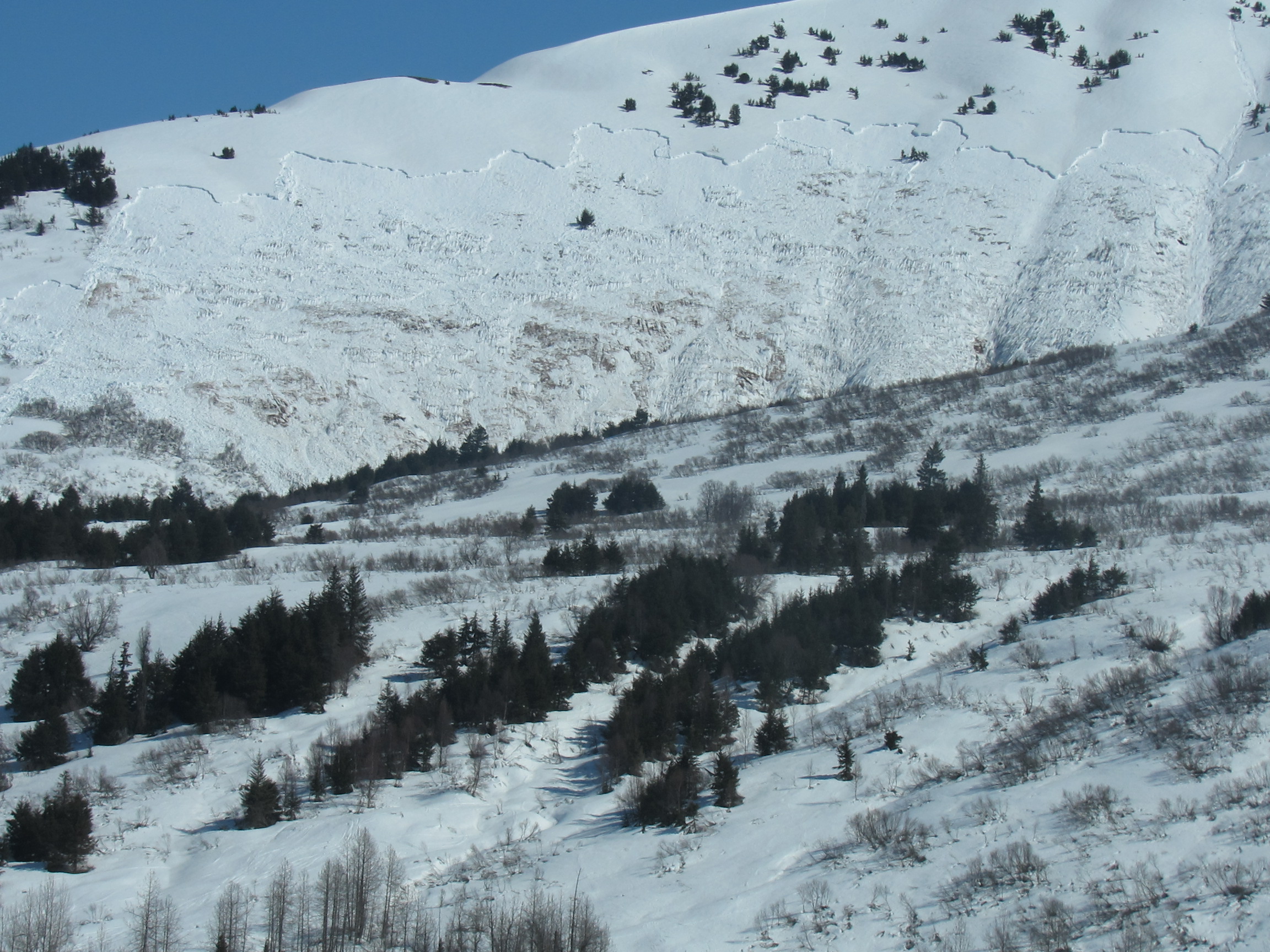
The avalanche danger will start out LOW but rise to HIGH as warming temperatures melt snow surfaces through the day. Frozen snow surfaces will allow for easy travel and safe conditions this morning, but natural and human-triggered avalanches will be likely when surface crusts melt in the heat of the day. Be careful to avoid being on or below steep slopes if you start to notice you are sinking past your boots in loose, unsupportable wet snow. Keep in mind that even northerly aspects may start to see more wet avalanche activity as they are now getting plenty of sunshine along with warm temperatures.

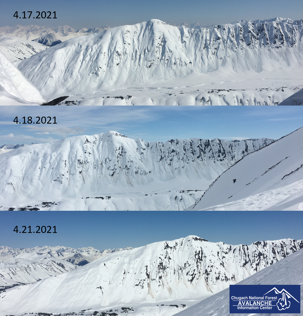
PORTAGE VALLEY, CROW PASS: Natural avalanches are expected to run down into the valleys this afternoon, and may bury portions of popular hiking trails like Portage Pass, Byron Glacier, and Crow Pass where they cross under large avalanche paths. Hiking on these trails is not recommended.

SNUG HARBOR, SEWARD, LOST LAKE: Cloudy skies overnight have resulted in little to no re-freeze overnight, and a chance of light rain today will increase the likelihood of wet avalanche activity. Avalanche danger is expected to rise more rapidly in these areas than it will in our core advisory area.

FRIDAY OUTLOOK: Our next avalanche advisory will be posted on Saturday, April 23. Increasing cloud cover through tonight mean we will see little to no re-freeze tonight. This will be followed by sunny skies and mountain temperatures in the 40s-50s F tomorrow, which will make for HIGH avalanche danger  with wet slab and loose wet avalanches likely. The biggest difference between today and tomorrow is that we will have less time before the snow heats up and becomes unstable during the daytime.

Thu, April 22nd, 2021
Alpine
Above 2,500'
4 - High
Avalanche risk
Treeline
1,000'-2,500'
4 - High
Avalanche risk
Below Treeline
Below 1,000'
4 - High
Avalanche risk
0 - No Rating
1 - Low
2 - Moderate
3 - Considerable
4 - High
5 - Extreme
Avalanche risk Avalanche risk Avalanche risk Avalanche risk Avalanche risk
Travel Advice Generally safe avalanche conditions. Watch for unstable snow on isolated terrain features. Heightened avalanche conditions on specific terrain features. Evaluate snow and terrain carefully; identify features of concern. Dangerous avalanche conditions. Careful snowpack evaluation, cautious route-finding, and conservative decision-making essential. Very dangerous avalanche conditions. Travel in avalanche terrain not recommended. Extraordinarily dangerous avalanche conditions. Avoid all avalanche terrain.
Likelihood of Avalanches Natural and human-triggered avalanches unlikely. Natural avalanches unlikely; human-triggered avalanches possible. Natural avalanches possible; human-triggered avalanches likely. Natural avalanches likely; human-triggered avalanches very likely. Natural and human-triggered avalanches certain.
Avalanche Size and Distribution Small avalanches in isolated areas or extreme terrain. Small avalanches in specific areas; or large avalanches in isolated areas. Small avalanches in many areas; or large avalanches in specific areas; or very large avalanches in isolated areas. Large avalanches in many areas; or very large avalanches in specific areas. Very large avalanches in many areas.
Recent Avalanches

The mountains are still shedding their snow as they transition to a springtime snowpack, and we continue to notice more natural avalanches. It is becoming increasingly difficult to track exactly when some of these avalanches are occurring, but here are a few that we know happened since the last advisory was posted on Tuesday morning:

Summit Lakes: A large natural wet slab avalanche occurred on Tuesday afternoon.

Tincan: We noticed a fresh glide avalanche on a south-facing slope below Tincan’s Common Bowl that occurred sometime between 12:30 and 2:00 p.m. yesterday afternoon.


Large wet slab avalanche on Raven Ridge that occurred Tuesday afternoon. Photo: Alex McLain, 04.21.2021.

Avalanche Problem 1
  • Spring Conditions
    Spring Conditions
  • Certain
    Very Likely
    Likely
    Possible
    Unlikely
    Likelihood
  • Historic (D4-5)
    Very Large (D3)
    Large (D2)
    Small (D1)
    Size
Spring Conditions
Warmth has a tricky effect on snow. On the one hand it speeds up the stabilization of the snowpack (reduces the chance of slab avalanches). But a SUDDEN rise of temperature increases the chance of slab avalanches considerably. When this warm period is followed by cooling down, then the chance of slab avalanches reduces. Even more so: the more often the temperature changes, the more stable the snowpack becomes when looking at slab avalanches. Once the temperature becomes too warm we have to deal with wet snow avalanches.

Likelihood of Avalanches
Terms such as "unlikely", "likely", and "certain" are used to define the scale, with the chance of triggering or observing avalanches increasing as we move up the scale. For our purposes, "Unlikely" means that few avalanches could be triggered in avalanche terrain and natural avalanches are not expected. "Certain" means that humans will be able to trigger avalanches on many slopes, and natural avalanches are expected.

Size of Avalanches
Avalanche size is defined by the largest potential avalanche, or expected range of sizes related to the problem in question. Assigned size is a qualitative estimate based on the destructive classification system and requires specialists to estimate the harm avalanches may cause to hypothetical objects located in the avalanche track (AAA 2016, CAA 2014). Under this schema, "Small" avalanches are not large enough to bury humans and are relatively harmless unless they carry people over cliffs or through trees or rocks. Moving up the scale, avalanches become "Large" enough to bury, injure, or kill people. "Very Large" avalanches may bury or destroy vehicles or houses, and "Historic" avalanches are massive events capable of altering the landscape.

Signal Word Size (D scale) Simple Descriptor
Small 1 Unlikely to bury a person
Large 2 Can bury a person
Very Large 3 Can destroy a house
Historic 4 & 5 Can destroy part or all of a village
More info at Avalanche.org

The mountain snowpack is continuing its annual transition from a dry, wintertime regime to a wet springtime pack. We have seen a widespread natural cycle since temperatures first heated up last Friday, and more natural activity is expected in the heat of the day today. There are a few things to be aware of as we continue on this springtime shed cycle.

  1. Northerly aspects are just starting to experience melting, and we have yet to see widespread avalanches on these slopes. Now that we are into late April, these slopes are getting plenty of sunshine. As temperatures warm, we can expect to start seeing increased activity on the northerly aspects.
  2. We have recently started to see avalanches failing on deeper weak layers that formed earlier in the season. This includes a large avalanche on Raven Ridge that occurred on Tuesday and another on Seattle Ridge earlier in the week. We are likely to see more similar activity in the next few days.
  3. Upper elevation slopes are generally colder, and slower in the transition to a springtime snowpack. It might still be possible to find dry snow in the highest north-facing slopes, which may still harbor the possibility of persistent slab avalanches failing on weak layers that formed during dry spells in March. It also means that there is plenty of snow that has yet to heat up and avalanche in these highest elevations.

There are a few wildcards today that make it a little bit more difficult to anticipate the timing of when we will start to see wet snow avalanches this afternoon. Increasing cloud cover will limit the heat input from direct sun, but clouds may also act like panels on a greenhouse, trapping in radiation from the sun without allowing the snow surface to cool itself by radiating heat back out to the sky. Moderate winds will have a cooling effect on the snow surface, which may delay surface melting and the onset of natural avalanche activity this afternoon.

The key to safe travel will be paying attention to indications of poor stability. As soon as you start to notice snow surfaces becoming unsupportable, it is time to head back to the parking lot. If you are sinking up past your boot tops in wet, sloppy snow, or if you are starting to notice rollerballs rolling down slopes, you can bet that conditions are quickly becoming dangerous. Be sure to plan your day so you don’t need to traverse under steep slopes in the afternoon, when natural avalanche activity will be likely.

Cornices: Daytime heating is making cornices more tender, increasing the likelihood of cornice fall. As always, be sure to give them plenty of space when traveling along ridgelines, and limit the time spent traveling under them.

Every day is bringing more natural avalanches. Here is the evolution of the south-facing terrain on Tincan since Saturday. 04.21.2021

Additional Concern
  • Glide Avalanches
    Glide Avalanches
Glide Avalanches
Glide Avalanches are the release of the entire snow cover as a result of gliding over the ground. Glide avalanches can be composed of wet, moist, or almost entirely dry snow. They typically occur in very specific paths, where the slope is steep enough and the ground surface is relatively smooth. They are often proceeded by full depth cracks (glide cracks), though the time between the appearance of a crack and an avalanche can vary between seconds and months. Glide avalanches are unlikely to be triggered by a person, are nearly impossible to forecast, and thus pose a hazard that is extremely difficult to manage.
More info at Avalanche.org

Glide cracks have been releasing for the past week. This includes some cracks that have been around for several weeks, and others that have only formed since temperatures warmed up last Friday. More glide activity is likely today. These can be large and destructive since they involve the entire season’s snowpack. Be sure to avoid spending time below glide cracks since they can release suddenly and unexpectedly.

Glide avalanche yesterday on a south-facing slope on Tincan. There are several other recent glide avalanches in this photo, as well as some large cracks that have not yet released. 04.21.2021

Weather
Thu, April 22nd, 2021

Yesterday: Temperatures reached the low 40’s to low 50’s F under clear skies, with overnight low temperatures in the low 30’s F. Winds were out of the east at 5-20 mph.

Today:  Cloud cover is expected to slowly increase during the day and into tonight, with scattered clouds in the afternoon and mostly cloudy skies tonight. Seward might even see light rain to 2500′. High temperatures are expected to be slightly cooler than yesterday, reaching the high 30’s to low 40’s F today and then dropping down to the low 20’s to low 30’s overnight. Easterly winds are expected at 10-20 mph near ridgetops.

Tomorrow:  Skies are expected to clear up tomorrow morning, with sunny skies and high temperatures in the 40’s-50’s F in the afternoon. Cloudy skies overnight tonight mean we will see little to no re-freeze overnight. Winds are expected to be light at around 5 mph out of the east.

PRECIPITATION 24-hour data (6am – 6am)

Temp Avg (F) Snow (in) Water (in) Snow Depth (in)
Center Ridge (1880′) 42 0 0 99
Summit Lake (1400′) 43 0 0 35
Alyeska Mid (1700′) 43 0 0 111

RIDGETOP 24-hour data (6am – 6am)

Temp Avg (F) Wind Dir Wind Avg (mph) Wind Gust (mph)
Sunburst (3812′) 35 ENE 9 27
Seattle Ridge (2400′) 43 SE 9 13
Observations
Recent Observations for Turnagain Pass
Date Region Location
04/16/24 Turnagain Observation: Cornbiscuit
04/15/24 Turnagain Observation: Taylor Pass
04/15/24 Turnagain Observation: Seward Highway – Tern Lake to Portage
04/14/24 Turnagain Observation: Sunburst
04/14/24 Turnagain Observation: Turnagain Pass Snomo
04/13/24 Turnagain Observation: Spokane Creek
04/11/24 Turnagain Observation: Tincan
04/10/24 Turnagain Avalanche: Seattle Ridge
04/10/24 Turnagain Observation: Cornbiscuit South Face
04/10/24 Turnagain Avalanche: Tincan
Riding Areas

The riding areas page has moved. Please click here & update your bookmarks.


Subscribe to Turnagain Pass
Avalanche Forecast by Email

This is a general backcountry avalanche advisory issued for Turnagain Arm with Turnagain Pass as the core advisory area. This advisory does not apply to highways, railroads or operating ski areas.