Turnagain Pass Avalanche Forecast
|
![]() ![]() |
The avalanche danger is expected to reach HIGH again today for springtime natural avalanches on steep terrain facing east, south and west. Cloudy skies have limited last night’s freeze and not only are natural large wet avalanches expected today with daytime warming, but human triggered wet avalanches will be likely on slopes with wet saturated snow. Additionally, watch for glide cracks that may release and cornices that may break easier with these warm conditions.
PORTAGE VALLEY, CROW PASS: Natural avalanches are expected to continue through the week in steep rocky terrain above summer hiking trails such as Byron Glacier Train and Crow Pass Trail. Avoiding summer trails that run through avalanche runout zones is recommended.
WEDNESDAY AVALANCHE OUTLOOK: There will be no avalanche forecast issued tomorrow, the next forecast will be Thursday, April 22nd. Mostly clear skies are expected to allow the snowpack to freeze Tuesday night and limit avalanche hazard early Wednesday morning. Once the sun melts the surface crusts, expected avalanche danger to rise back to HIGH tomorrow; similar to what we have seen the past several days.
CNFAIC End Of Season Operations: Daily avalanche forecasts have ended as our forecast season and funding winds down. We will forecast today, Thur, Sat, and Sun this week.
Widespread natural wet loose and wet slab avalanches have been seen over the past 4 days (video below). With cloudy skies yesterday and limited observations, we only know of a few new confirmed natural avalanches, these were mostly seen in the Summit Lake area. There have been a few slabs releasing on northerly aspects as well. One in Girdwood Valley that released on a northerly aspect late Sunday and another in Summit Lake, north of Manitoba.
As for human triggered avalanches, a snowboarder triggered a wet sluff on the backside of Seattle Ridge on Sunday (photo below). They were caught when trying to evade their sluff and described the experience this way: “pushed me down the face like a bulldozer”. Later the rider said it was not a good feeling being pushed by so much weight and ‘no joke’.
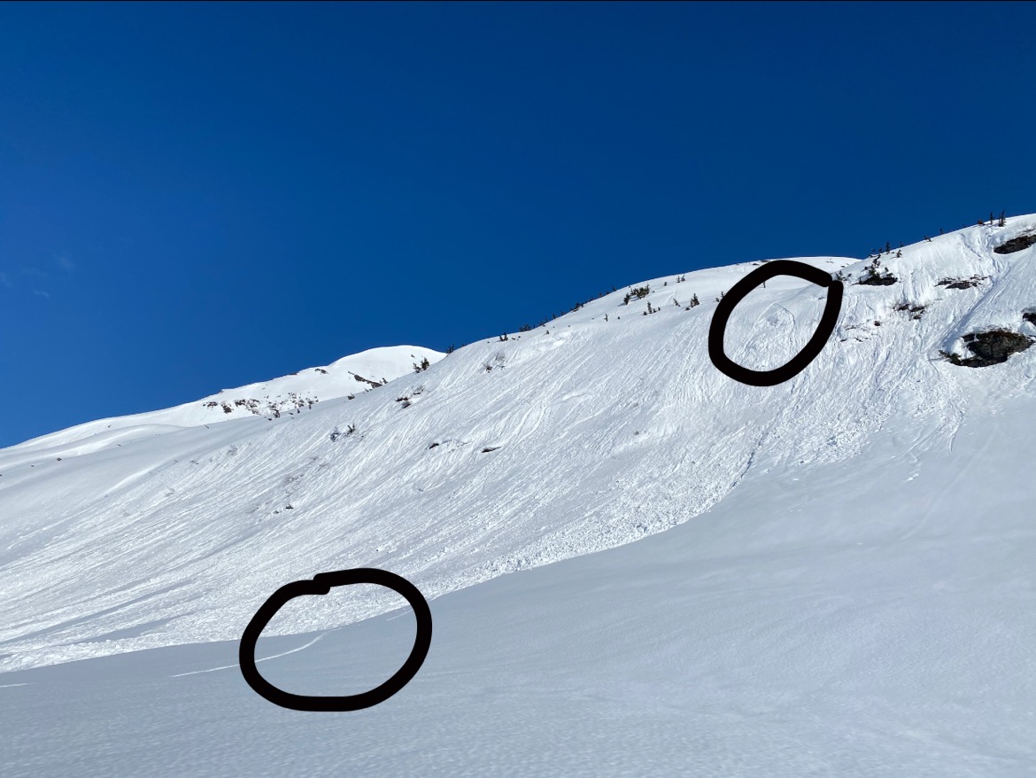
Snowboarder triggered wet loose on the backside of Seattle Ridge. Circles mark where the rider triggered the sluff and where they ended up at the toe of the debris. 4.18.21. Will Morrison. (Thanks Will for sharing!)
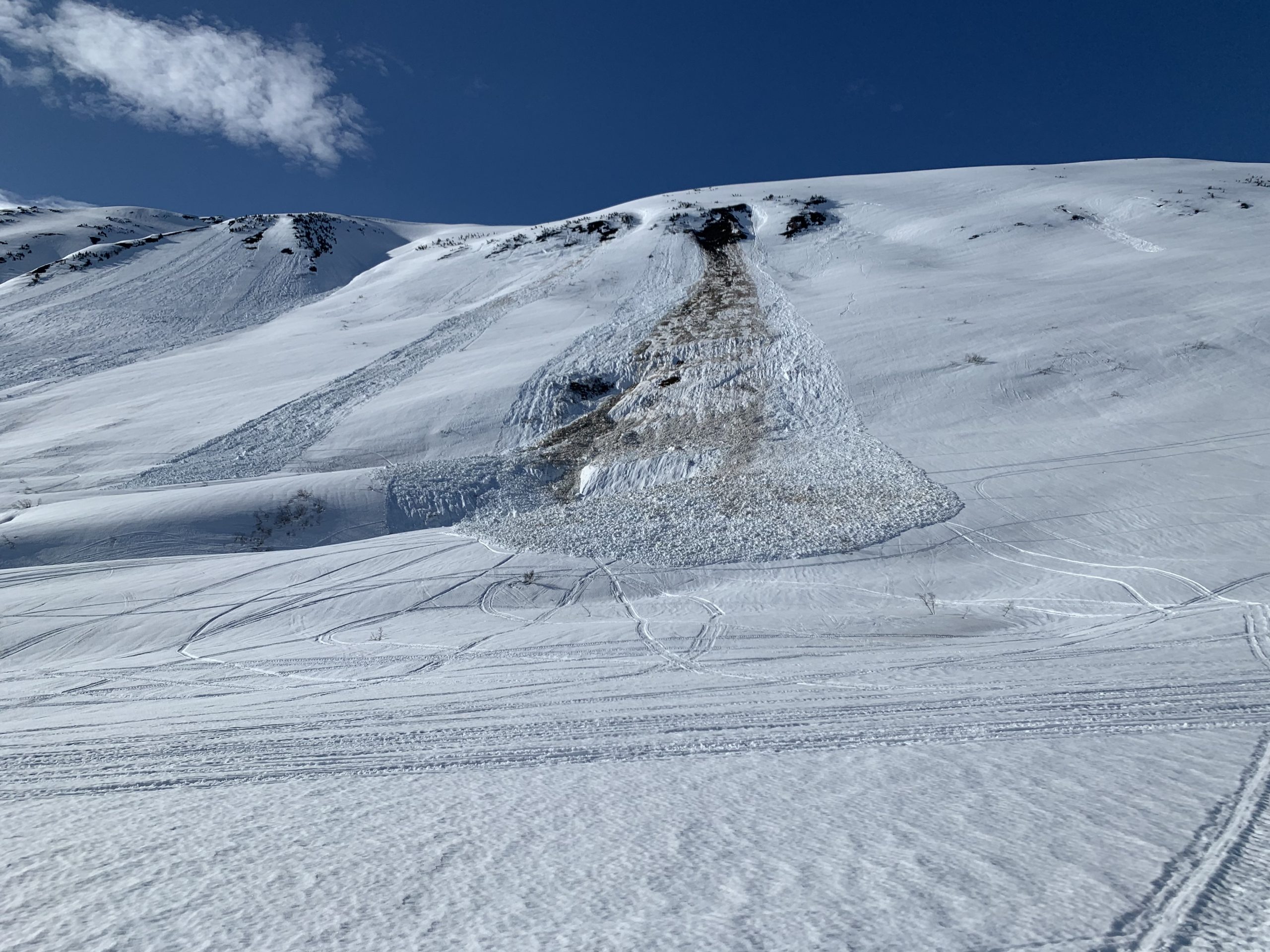
Glide avalanche that released on Sunday midday, just 300 yards to the south from the motorized up-track on Seattle Ridge. 4.18.21. Brent Byrne.
Signal Word | Size (D scale) | Simple Descriptor |
Small | 1 | Unlikely to bury a person |
Large | 2 | Can bury a person |
Very Large | 3 | Can destroy a house |
Historic | 4 & 5 | Can destroy part or all of a village |
The springtime transition continues with more natural avalanche activity expected today. After three days of intense sunshine and warm temperatures at all elevations, clouds moved in yesterday with strong east winds and a trace of rain to 2,000-3,000′. That front is headed out today and some sunshine should start making its way back in by the afternoon. Last night’s refreeze is likely to be slim to none with the cloud cover. It should not take much solar input today, even with some cloud cover, to melt any crusts and continue the wet avalanche cycle we’ve been seeing.
Aspect: Most of the natural avalanche activity has been on east, south, and west aspects due to the direct sunshine. However, there have been a few reports of slabs releasing on north aspects. With those reports, coupled with cloudy skies last night warming all aspects, and early morning and late evening sun hitting northerly terrain, we need to be aware that some north aspects could start losing their strength and begin to avalanche.
Steering clear of slopes with wet, mushy and saturated snow and being out from under any overhead hazards are key. As you can see in the video, steep rocky terrain is shedding its snow easily and it’s not a time to be under this type of terrain or any cornices for that matter. Cornices are peeling away and even a small chunk that falls could initiate a large avalanche. Steep slopes we’d like to ride or ski should be avoided when the surface snow is ‘punchy’ with several inches to a foot or more of wet saturated snow. Triggering a wet sluff can be easier than might be thought and very difficult to escape from. Triggering a wet slab is likely as well, and much more destructive. We have seen many small wet loose avalanches initiate wet slabs and this pattern should continue.
Timing is everything: After today, we should start back into a springtime melt/freeze cycle. This is good news for those interested in corn snow conditions. As skies clear back up we can expect wet surface snow to freeze at night and melt during the day. Avalanche danger will follow this pattern: lower danger in the early morning when the snow is frozen, higher danger as the snow melts and loses its strength during the day.
Signal Word | Size (D scale) | Simple Descriptor |
Small | 1 | Unlikely to bury a person |
Large | 2 | Can bury a person |
Very Large | 3 | Can destroy a house |
Historic | 4 & 5 | Can destroy part or all of a village |
On upper elevation north aspects that have mostly dry snow, we are concerned that a person could trigger a dry slab avalanche in the 2-3′ deep range. Even if the top inch or two of snow is moist or wet, there can still be dry snow issues below this. There are old weak layers from March and possibly there could be weak snow under last week’s storm snow. Looking for signs of instability and assessing the snowpack before committing to steep north aspects with little or no sun effect will be prudent.
Glide cracks are popping… Several glide avalanches were reported and seen through the region from Girdwood to Seward over the past three days. As with the concerns stated above, avoiding being under overhead hazards includes glide cracks. Keep you eye out for them as several cracks are opening up each day. There are a few on Seattle Ridge we have our eye on.
Glide avalanche on Mt. Marathon in Seward. 4.18.21. Photo Anonymous.
Yesterday: Mostly clear skies transitioned to mostly cloudy by the late afternoon as a front moved in from the south with slightly cooler air and strong east winds. A trace of light rain fell to between 2,000 and 3,000′. Ridgetop winds blew in the 30-50mph range with gusts to 70mph in the evening. Ridgetop temperatures were in the 40’sF while 1,000′ temps were in the 50’sF.
Today: Partly cloudy skies are over the region this morning, which has kept valley bottom temperatures in the 40’sF. As the front moves north, we should see lingering clouds through the day with some areas seeing the sun. Although the Sunburst weather station has dipped to the low 30’sF for first time since Friday morning, daytime temperatures should climb to the low 50’sF at 1,000′ and near 40F along ridgelines. Ridgetop winds are decreasing and should be in the 5-15mph range from the east.
Tomorrow: Sunny and warm with a light east breeze. Temperatures should reach the low/mid 50’s at 1,000′ and ~40-45F along ridgelines with lows near 30F. Easterly ridgetop winds look to be 5-10mph. From the National Weather Service’s forecast discussion:
"Wednesday, the Rex block pattern becomes established keeping much of Southcentral quiet and dry and loads of sunshine." .... Thurs - Sunday: "Much of south central will benefit from the spring sunshine. Daytime temperatures should be well above normal for this time of year ...."
PRECIPITATION 24-hour data (6am – 6am)
Temp Avg (F) | Snow (in) | Water (in) | Snow Depth (in) | |
---|---|---|---|---|
Center Ridge (1880′) | 45 | 0 | trace | 103 |
Summit Lake (1400′) | 45 | 0 | trace | 38 |
Alyeska Mid (1700′) | 42 | 0 | trace | 116 |
RIDGETOP 24-hour data (6am – 6am)
Temp Avg (F) | Wind Dir | Wind Avg (mph) | Wind Gust (mph) | |
---|---|---|---|---|
Sunburst (3812′) | 36 | NE | 25 | 70 |
Seattle Ridge (2400′) | 41 | SE | 13 | 22 |
Date | Region | Location | Observer |
---|---|---|---|
05/22/23 | Turnagain | Avalanche: Tincan | Nick D'Alessio |
05/12/23 | Turnagain | Avalanche: Tincan, Sunburst, Magnum, Cornbiscuit | Heather Thamm |
05/07/23 | Turnagain | Observation: Tincan – Bear Tracks | CNFAIC Staff |
05/05/23 | Turnagain | Observation: Seattle Ridge | AS/ WW Forecaster |
05/02/23 | Turnagain | Observation: Cornbiscuit | Schauer/ Sturgess Forecaster |
05/02/23 | Turnagain | Observation: Seward Hwy Turnagain Pass | Joel Curtis |
04/30/23 | Turnagain | Observation: Magnum | Ayla, Kit Crosby, Barton |
04/29/23 | Turnagain | Observation: Tincan | John Sykes |
04/28/23 | Turnagain | Avalanche: Taylor Pass/Pastoral | Schauer/ Creighton Forecaster |
04/28/23 | Turnagain | Avalanche: Tincan | Andy Moderow |
Status of riding areas across the Chugach NF is managed by the Glacier and Seward Ranger Districts, not avalanche center staff. Riding area information is posted as a public service to our users and updated based on snow depth and snow density to prevent resource damage at trailhead locations. Riding area questions contact: mailroom_r10_chugach@fs.fed.us
Area | Status | Weather & Riding Conditions |
---|---|---|
Glacier District |
Subscribe to Turnagain Pass
Avalanche Forecast by Email
This is a general backcountry avalanche advisory issued for Turnagain Arm with Turnagain Pass as the core advisory area. This advisory does not apply to highways, railroads or operating ski areas.