Turnagain Pass RSS

Archives
ARCHIVED - Forecasts expire after 24 hours.
Issued
Sun, April 4th, 2021 - 7:00AM
Expires
Mon, April 5th, 2021 - 7:00AM
Forecaster
Andrew Schauer
Avalanche risk The Bottom Line

The avalanche danger is expected to rise to CONSIDERABLE above 2500’ as winds and snowfall continue into this afternoon. While the bulk of this storm is expected to hit north of our core advisory area, we will still see some of the action. It is likely a person will be able to trigger an avalanche up to a foot deep on wind-loaded slopes, and possibly deeper in the mountains on the north end of the Girdwood Valley. It is possible an avalanche triggered in the new snow can step down to persistent weak layers buried in the upper 1-3’ of the snowpack.

The avalanche danger will remain MODERATE below 2500’, where it will be possible to trigger a smaller avalanche within the new snow, as well as a larger avalanche on the weak layers in the upper snowpack. Wet avalanches will be a concern for slopes at elevations below 1000’, where we may see rain during the day and temperatures have remained above freezing for the past 24 hours.

Sun, April 4th, 2021
Alpine
Above 2,500'
3 - Considerable
Avalanche risk
Treeline
1,000'-2,500'
2 - Moderate
Avalanche risk
Below Treeline
Below 1,000'
2 - Moderate
Avalanche risk
0 - No Rating
1 - Low
2 - Moderate
3 - Considerable
4 - High
5 - Extreme
Avalanche risk Avalanche risk Avalanche risk Avalanche risk Avalanche risk
Travel Advice Generally safe avalanche conditions. Watch for unstable snow on isolated terrain features. Heightened avalanche conditions on specific terrain features. Evaluate snow and terrain carefully; identify features of concern. Dangerous avalanche conditions. Careful snowpack evaluation, cautious route-finding, and conservative decision-making essential. Very dangerous avalanche conditions. Travel in avalanche terrain not recommended. Extraordinarily dangerous avalanche conditions. Avoid all avalanche terrain.
Likelihood of Avalanches Natural and human-triggered avalanches unlikely. Natural avalanches unlikely; human-triggered avalanches possible. Natural avalanches possible; human-triggered avalanches likely. Natural avalanches likely; human-triggered avalanches very likely. Natural and human-triggered avalanches certain.
Avalanche Size and Distribution Small avalanches in isolated areas or extreme terrain. Small avalanches in specific areas; or large avalanches in isolated areas. Small avalanches in many areas; or large avalanches in specific areas; or very large avalanches in isolated areas. Large avalanches in many areas; or very large avalanches in specific areas. Very large avalanches in many areas.
Avalanche Problem 1
  • Wind Slabs
    Wind Slabs
  • Certain
    Very Likely
    Likely
    Possible
    Unlikely
    Likelihood
  • Historic (D4-5)
    Very Large (D3)
    Large (D2)
    Small (D1)
    Size
Wind Slabs
Wind Slab avalanches are the release of a cohesive layer of snow (a slab) formed by the wind. Wind typically transports snow from the upwind sides of terrain features and deposits snow on the downwind side. Wind slabs are often smooth and rounded and sometimes sound hollow, and can range from soft to hard. Wind slabs that form over a persistent weak layer (surface hoar, depth hoar, or near-surface facets) may be termed Persistent Slabs or may develop into Persistent Slabs.

Likelihood of Avalanches
Terms such as "unlikely", "likely", and "certain" are used to define the scale, with the chance of triggering or observing avalanches increasing as we move up the scale. For our purposes, "Unlikely" means that few avalanches could be triggered in avalanche terrain and natural avalanches are not expected. "Certain" means that humans will be able to trigger avalanches on many slopes, and natural avalanches are expected.

Size of Avalanches
Avalanche size is defined by the largest potential avalanche, or expected range of sizes related to the problem in question. Assigned size is a qualitative estimate based on the destructive classification system and requires specialists to estimate the harm avalanches may cause to hypothetical objects located in the avalanche track (AAA 2016, CAA 2014). Under this schema, "Small" avalanches are not large enough to bury humans and are relatively harmless unless they carry people over cliffs or through trees or rocks. Moving up the scale, avalanches become "Large" enough to bury, injure, or kill people. "Very Large" avalanches may bury or destroy vehicles or houses, and "Historic" avalanches are massive events capable of altering the landscape.

Signal Word Size (D scale) Simple Descriptor
Small 1 Unlikely to bury a person
Large 2 Can bury a person
Very Large 3 Can destroy a house
Historic 4 & 5 Can destroy part or all of a village
More info at Avalanche.org

Winds picked up late in the day yesterday, with sustained speeds around 15 mph and gusts to 25 mph at ridgetops since around 5 p.m. With around 6-12″ of soft snow near the surface prior to the bump in winds, we already had plenty of loose snow available for slab building, and we are expecting to get some more snow this morning before skies start to clear up in the afternoon. The storm is expected to head to the north of us, leaving Turnagain Pass with only a few inches of new snow but possibly bringing heavy snowfall towards the north end of the Girdwood valley. We saw large natural and human-triggered avalanches on Raggedtop (details here, here and here) during both of the last two storm events, and similar activity is likely today if the storm delivers. The stakes are a little bit higher even for relatively smaller wind slab avalanches, which could step down to one of several persistent weak layers in the upper 3′ of the snowpack (see problem 2 below), resulting in a larger avalanche.

Safe travel today will require being aware of changing conditions as the storm moves through. The increase in danger will depend partly on the amount of new snow we get, but the increased winds will be enough to create sensitive slabs near ridgelines, below convexities, and in cross-loaded gullies. Be on the lookout for our typical signs of instability- shooting cracks, collapsing, and recent avalanche activity. Today’s active weather will require cautious route-finding, especially at higher elevations.

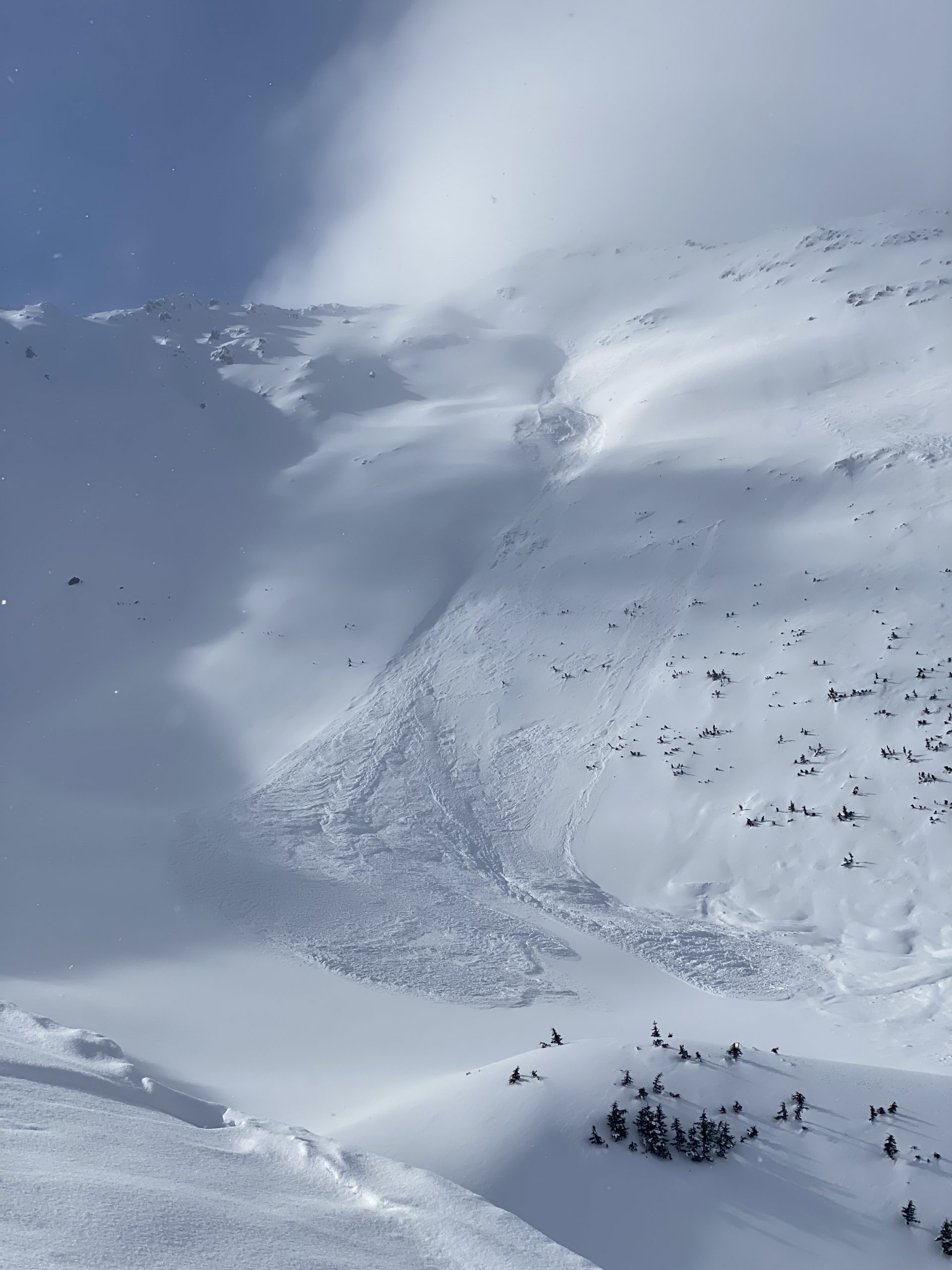
This slope on Raggedtop has slid three times following recent snow and winds. We are anticipating similar activity today, especially towards the north end of the Girdwood valley. Photo: George Creighton, 04.01.2021.

Loose snow avalanches: Steep slopes that have been sheltered from the wind have up to a foot of loose snow sitting on top of firm surfaces. It will be easy to trigger dry loose avalanches (sluffs) today, and they can pick up enough volume and speed to carry a person. If the sun comes out later in the day, we will likely see some wet loose activity as well. While it is unlikely they will be big enough to bury you, they can be dangerous if they drag you into terrain traps like cliffs, trees, rocks, or gullies.

Avalanche Problem 2
  • Persistent Slabs
    Persistent Slabs
  • Certain
    Very Likely
    Likely
    Possible
    Unlikely
    Likelihood
  • Historic (D4-5)
    Very Large (D3)
    Large (D2)
    Small (D1)
    Size
Persistent Slabs
Persistent Slab avalanches are the release of a cohesive layer of snow (a slab) in the middle to upper snowpack, when the bond to an underlying persistent weak layer breaks. Persistent layers include: surface hoar, depth hoar, near-surface facets, or faceted snow. Persistent weak layers can continue to produce avalanches for days, weeks or even months, making them especially dangerous and tricky. As additional snow and wind events build a thicker slab on top of the persistent weak layer, this avalanche problem may develop into a Deep Persistent Slab.

Likelihood of Avalanches
Terms such as "unlikely", "likely", and "certain" are used to define the scale, with the chance of triggering or observing avalanches increasing as we move up the scale. For our purposes, "Unlikely" means that few avalanches could be triggered in avalanche terrain and natural avalanches are not expected. "Certain" means that humans will be able to trigger avalanches on many slopes, and natural avalanches are expected.

Size of Avalanches
Avalanche size is defined by the largest potential avalanche, or expected range of sizes related to the problem in question. Assigned size is a qualitative estimate based on the destructive classification system and requires specialists to estimate the harm avalanches may cause to hypothetical objects located in the avalanche track (AAA 2016, CAA 2014). Under this schema, "Small" avalanches are not large enough to bury humans and are relatively harmless unless they carry people over cliffs or through trees or rocks. Moving up the scale, avalanches become "Large" enough to bury, injure, or kill people. "Very Large" avalanches may bury or destroy vehicles or houses, and "Historic" avalanches are massive events capable of altering the landscape.

Signal Word Size (D scale) Simple Descriptor
Small 1 Unlikely to bury a person
Large 2 Can bury a person
Very Large 3 Can destroy a house
Historic 4 & 5 Can destroy part or all of a village
More info at Avalanche.org

In addition to the problems related to new and wind-transported snow mentioned above, we are still dealing with multiple persistent weak layers in the upper snowpack. We continue to find layers of buried surface hoar and near-surface facets in the upper 3′ of the snowpack, and although they are becoming more stubborn it is still possible to trigger an avalanche on these layers. With new snow and winds at upper elevations, and a mix of wet snow and rain falling on a wet surface at low elevations, these layers may be a little more sensitive today.

The most likely places to trigger an avalanche on this layer are the same as those mentioned in problem 1 above- steep slopes near ridgelines, convexities, and mid-slope gullies. Freshly wind-loaded slopes are most suspect, but it will also be important to remember that slopes that have been previously wind-loaded will also be likely spots to trigger an avalanche on these weak layers.

Weather
Sun, April 4th, 2021

Yesterday: Temperatures were in the high 20’s F at upper elevations, reaching the high 30’s to low 40’s F near the valleys. Skies were cloudy all day, with light snowfall beginning overnight. Winds were light for most of the day, increasing to 15 mph with gusts to 32 mph out of the east around 5 p.m.

Today: Snowfall is expected until early afternoon, with 1-2″ expected at Turnagain Pass, and up to a foot possible north of Girdwood. We may see mixed rain and snow up to around 800′. Winds are expected to continue at 15-20 mph out of the south, shifting westerly in the afternoon. Cloudy skies are expected to break up in the afternoon as the winds shift westerly. We should see high temperatures in the mid 20’s to mid 30’s F, with overnight lows in the low to mid teens F.

Tomorrow: Mostly sunny skies are expected as winds shift back to the north, bringing cold and dry air to our area. Temperatures are expected in the low teens to mid 20’s F. Winds are expected to continue tomorrow, with sustained speeds at 15-20 mph.

PRECIPITATION 24-hour data (6am – 6am)

Temp Avg (F) Snow (in) Water (in) Snow Depth (in)
Center Ridge (1880′) 31 tr 0.1 109
Summit Lake (1400′) 32 0 0 48
Alyeska Mid (1700′) 30 1 0.06 115

RIDGETOP 24-hour data (6am – 6am)

Temp Avg (F) Wind Dir Wind Avg (mph) Wind Gust (mph)
Sunburst (3812′) 22 SW-SE* 7* 32
Seattle Ridge (2400′) 24 E 9* 19

*Winds shifted directions and increased yesterday evening, with sustained speeds of 10-15 mph.

Observations
Recent Observations for Turnagain Pass
Date Region Location
04/16/24 Turnagain Observation: Cornbiscuit
04/15/24 Turnagain Observation: Taylor Pass
04/15/24 Turnagain Observation: Seward Highway – Tern Lake to Portage
04/14/24 Turnagain Observation: Sunburst
04/14/24 Turnagain Observation: Turnagain Pass Snomo
04/13/24 Turnagain Observation: Spokane Creek
04/11/24 Turnagain Observation: Tincan
04/10/24 Turnagain Avalanche: Seattle Ridge
04/10/24 Turnagain Observation: Cornbiscuit South Face
04/10/24 Turnagain Avalanche: Tincan
Riding Areas

The riding areas page has moved. Please click here & update your bookmarks.


Subscribe to Turnagain Pass
Avalanche Forecast by Email

This is a general backcountry avalanche advisory issued for Turnagain Arm with Turnagain Pass as the core advisory area. This advisory does not apply to highways, railroads or operating ski areas.