Turnagain Pass RSS

Archives
ARCHIVED - Forecasts expire after 24 hours.
Issued
Mon, March 28th, 2022 - 7:00AM
Expires
Tue, March 29th, 2022 - 7:00AM
Forecaster
John Sykes
High Avalanche Danger
Travel in avalanche terrain is not recommended. Avoid being on or beneath all steep slopes.
Avalanche risk The Bottom Line

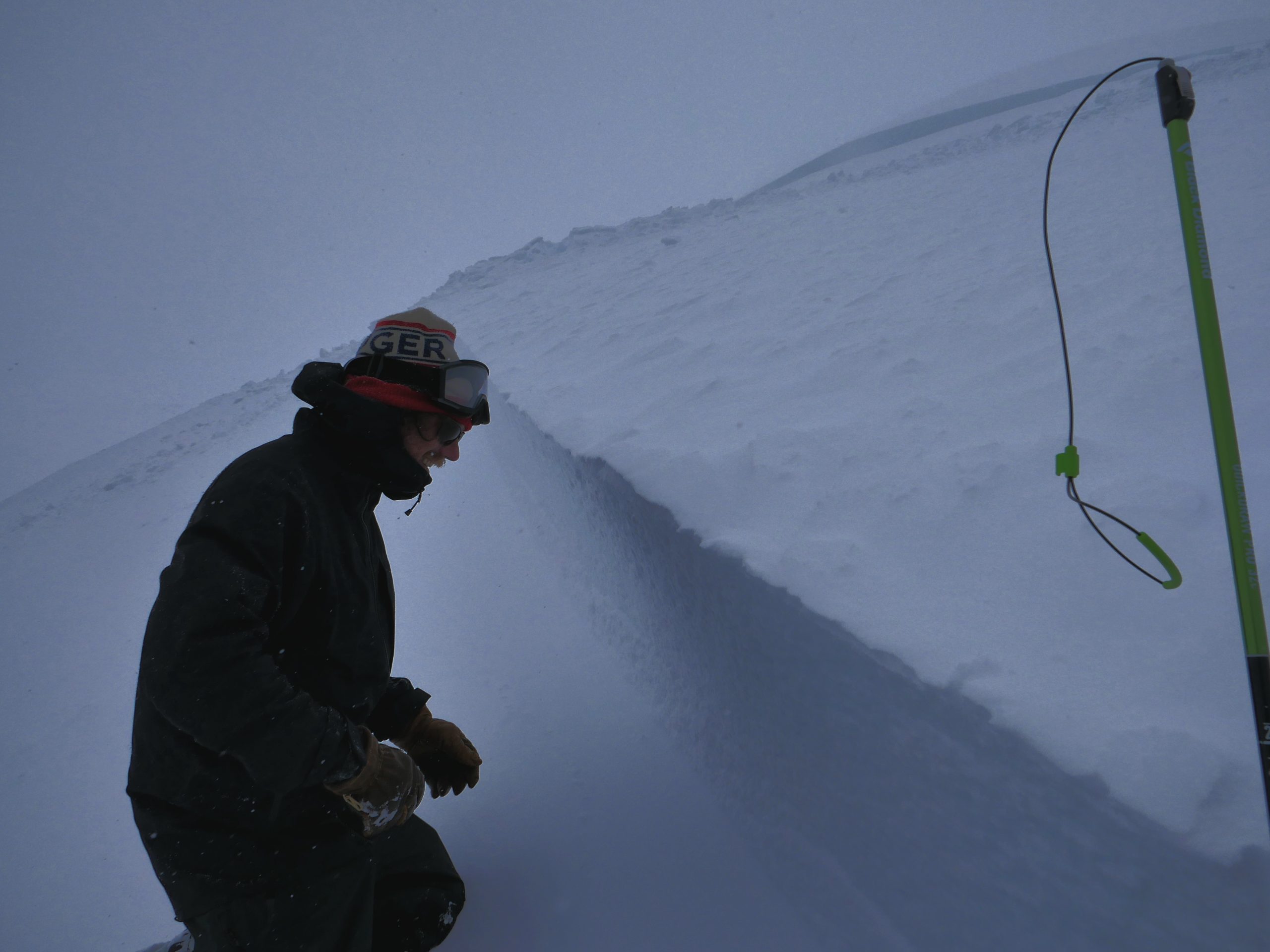
The avalanche danger is HIGH at all elevations, and travel in avalanche terrain is not recommended. Another storm is impacting the forecast area today adding stress to an already stressed out snowpack, with potential for very large natural and human triggered avalanches. The consequences of being involved with this type of avalanche are dire, and it is not worth the risk. We recommend avoiding all avalanche terrain including flat terrain underneath steeper slopes.

SUMMIT LAKE: This area has a weak and thin snowpack and even small amounts of new snow combined with strong winds can be enough to cause large avalanches on buried weak layers. Conservative decision-making is recommended during the storm today.

SEWARD/LOST LAKE/SNUG HARBOR: Snowfall and strong winds across the Kenai peninsula are causing increased avalanche danger and conservative decision-making is recommended while the snowpack adjusts to the new load.

Special Announcements
  • The National Weather Service has issued a Winter Weather Advisory through 1 pm today for snow and high winds.
  • Chugach State Park: Cleanup crews are still working on clearing a large avalanche debris pile across Hiland road in the South Fork of Eagle River.
Mon, March 28th, 2022
Alpine
Above 2,500'
4 - High
Avalanche risk
Treeline
1,000'-2,500'
4 - High
Avalanche risk
Below Treeline
Below 1,000'
4 - High
Avalanche risk
0 - No Rating
1 - Low
2 - Moderate
3 - Considerable
4 - High
5 - Extreme
Avalanche risk Avalanche risk Avalanche risk Avalanche risk Avalanche risk
Travel Advice Generally safe avalanche conditions. Watch for unstable snow on isolated terrain features. Heightened avalanche conditions on specific terrain features. Evaluate snow and terrain carefully; identify features of concern. Dangerous avalanche conditions. Careful snowpack evaluation, cautious route-finding, and conservative decision-making essential. Very dangerous avalanche conditions. Travel in avalanche terrain not recommended. Extraordinarily dangerous avalanche conditions. Avoid all avalanche terrain.
Likelihood of Avalanches Natural and human-triggered avalanches unlikely. Natural avalanches unlikely; human-triggered avalanches possible. Natural avalanches possible; human-triggered avalanches likely. Natural avalanches likely; human-triggered avalanches very likely. Natural and human-triggered avalanches certain.
Avalanche Size and Distribution Small avalanches in isolated areas or extreme terrain. Small avalanches in specific areas; or large avalanches in isolated areas. Small avalanches in many areas; or large avalanches in specific areas; or very large avalanches in isolated areas. Large avalanches in many areas; or very large avalanches in specific areas. Very large avalanches in many areas.
Avalanche Problem 1
  • Storm Slabs
    Storm Slabs
  • Certain
    Very Likely
    Likely
    Possible
    Unlikely
    Likelihood
  • Historic (D4-5)
    Very Large (D3)
    Large (D2)
    Small (D1)
    Size
Storm Slabs
Storm Slab avalanches are the release of a cohesive layer (a slab) of new snow that breaks within new snow or on the old snow surface. Storm-slabs typically last between a few hours and few days (following snowfall). Storm-slabs that form over a persistent weak layer (surface hoar, depth hoar, or near-surface facets) may be termed Persistent Slabs or may develop into Persistent Slabs.

Likelihood of Avalanches
Terms such as "unlikely", "likely", and "certain" are used to define the scale, with the chance of triggering or observing avalanches increasing as we move up the scale. For our purposes, "Unlikely" means that few avalanches could be triggered in avalanche terrain and natural avalanches are not expected. "Certain" means that humans will be able to trigger avalanches on many slopes, and natural avalanches are expected.

Size of Avalanches
Avalanche size is defined by the largest potential avalanche, or expected range of sizes related to the problem in question. Assigned size is a qualitative estimate based on the destructive classification system and requires specialists to estimate the harm avalanches may cause to hypothetical objects located in the avalanche track (AAA 2016, CAA 2014). Under this schema, "Small" avalanches are not large enough to bury humans and are relatively harmless unless they carry people over cliffs or through trees or rocks. Moving up the scale, avalanches become "Large" enough to bury, injure, or kill people. "Very Large" avalanches may bury or destroy vehicles or houses, and "Historic" avalanches are massive events capable of altering the landscape.

Signal Word Size (D scale) Simple Descriptor
Small 1 Unlikely to bury a person
Large 2 Can bury a person
Very Large 3 Can destroy a house
Historic 4 & 5 Can destroy part or all of a village
More info at Avalanche.org

We hate to beat a dead horse, but travel in avalanche terrain is not recommended today.

Another storm is impacting the region today, right on the heels of the last major loading event which caused massive natural avalanches throughout the area. The snowpack has not had enough time to adjust to the previous load before this latest round of snowfall arrived, so we expect that conditions remain very unstable and the potential for very large avalanches is still very real. Turnagain Pass and Girdwood have received 6-12″ of new snow in the past 24 hours and are expected to get another 5-10″ today. Portage and Placer have already received 12-18″ of snowfall with an additional 12-16″ expected today. Strong winds have accompanied the snowfall the past 12 hours, with sustained averages of 40-50 mph and gusts of 70-80 mph.

Fresh wind slabs up to 2-3′ deep are very likely today and could release naturally or be triggered by people. With the strength of these winds we expect that wind slabs exist in the alpine and treeline elevation bands. Storm slabs are also likely as the new snow totals increase throughout the day. The bigger issue is the potential for very large and wide propagating avalanches on deeper weak layers, so please check out problem 2 for that discussion.

Snowfall all along the east and south coasts of the Kenai peninsula today with storm totals estimated between 10-24″ in the forecast area. Graphic from Windy.com 3.28.22

Avalanche Problem 2
  • Persistent Slabs
    Persistent Slabs
  • Certain
    Very Likely
    Likely
    Possible
    Unlikely
    Likelihood
  • Historic (D4-5)
    Very Large (D3)
    Large (D2)
    Small (D1)
    Size
Persistent Slabs
Persistent Slab avalanches are the release of a cohesive layer of snow (a slab) in the middle to upper snowpack, when the bond to an underlying persistent weak layer breaks. Persistent layers include: surface hoar, depth hoar, near-surface facets, or faceted snow. Persistent weak layers can continue to produce avalanches for days, weeks or even months, making them especially dangerous and tricky. As additional snow and wind events build a thicker slab on top of the persistent weak layer, this avalanche problem may develop into a Deep Persistent Slab.

Likelihood of Avalanches
Terms such as "unlikely", "likely", and "certain" are used to define the scale, with the chance of triggering or observing avalanches increasing as we move up the scale. For our purposes, "Unlikely" means that few avalanches could be triggered in avalanche terrain and natural avalanches are not expected. "Certain" means that humans will be able to trigger avalanches on many slopes, and natural avalanches are expected.

Size of Avalanches
Avalanche size is defined by the largest potential avalanche, or expected range of sizes related to the problem in question. Assigned size is a qualitative estimate based on the destructive classification system and requires specialists to estimate the harm avalanches may cause to hypothetical objects located in the avalanche track (AAA 2016, CAA 2014). Under this schema, "Small" avalanches are not large enough to bury humans and are relatively harmless unless they carry people over cliffs or through trees or rocks. Moving up the scale, avalanches become "Large" enough to bury, injure, or kill people. "Very Large" avalanches may bury or destroy vehicles or houses, and "Historic" avalanches are massive events capable of altering the landscape.

Signal Word Size (D scale) Simple Descriptor
Small 1 Unlikely to bury a person
Large 2 Can bury a person
Very Large 3 Can destroy a house
Historic 4 & 5 Can destroy part or all of a village
More info at Avalanche.org

Very large avalanches that have the potential to propagate thousands of feet wide and be triggered remotely from flat terrain hundreds of feet below the release area are a real possibility today. These avalanches are likely unsurvivable if a person is involved. The amount of natural avalanches observed during and after the last storm, on Friday and Saturday, combined with the continued remote triggering (see ob here) and whumphing (see ob here) throughout Turnagain Pass are very clear signs that the mountains are telling us to stay away. Today would be a good day to bail on the backcountry and pony up for a lift ticket.

The cause of these unique conditions are several persistent weak layers buried within the snowpack. There are three layers of buried surface hoar that were buried on March 2nd, March 16th, and March 22nd that are likely culprits for the type of avalanche activity we have seen, with remote triggering, very wide propagation, and relatively low angle terrain producing large avalanches. Another potential culprit is a layer of facets that were formed on the snow surface and buried on March 22nd. Andrew’s crown profile of the remote triggered avalanche on Pete’s N indicated that the facets were responsible for this impressive event (see video below and ob here).

Crown of a very large avalanche on Pete’s N that was triggered from 300′ below on flat terrain. Photo 3.27.22

Weather
Mon, March 28th, 2022

Yesterday: Yesterday started off cool and clear before the storm moved in with snowfall starting in the afternoon and continuing throughout the day. Winds picked up around 2 pm and then really ramped up at 5 pm, with sustained averages of 40-50 mph and gusts of 70-80 mph for the past 12 hours. So far the storm has produced about 6-12″ of new snow in Turnagain Pass and Girdwood, with 12-18″ in Portage and Placer. Snow line was down to sea level.

Today: Another 5-10″ of snow is expected today in Turnagain Pass and Girdwood with snow line rising to 500′. Portage and Placer are expected to get another 12-16″ of snow today. Winds will remain high with averages in the 30-50 mph range and gusts up to 60-80 mph at upper elevations throughout the day before starting to taper off this evening.

Tomorrow: The storm is forecast to peter out this evening with snowfall ending around midnight and wind speeds reducing to 10-20 mph out of the SE overnight. Tuesday should have relatively light winds and overcast to broken cloud cover. Wednesday and Thursday look similar, with light winds and low level clouds.

PRECIPITATION 24-hour data (6am – 6am)

Temp Avg (F) Snow (in) Water (in) Snow Depth (in)
Center Ridge (1880′) 29 8 0.7 123
Summit Lake (1400′) 28 3 0.4 42
Alyeska Mid (1700′) 29 8 0.7 NA

RIDGETOP 24-hour data (6am – 6am)

Temp Avg (F) Wind Dir Wind Avg (mph) Wind Gust (mph)
Sunburst (3812′) 18 ENE 34 87
Seattle Ridge (2400′) 23 NA NA NA

* Seattle Ridge wind sensor is rimmed over and not reporting accurate data.

Observations
Recent Observations for Turnagain Pass
Date Region Location
04/15/24 Turnagain Observation: Taylor Pass
04/14/24 Turnagain Observation: Sunburst
04/14/24 Turnagain Observation: Turnagain Pass Snomo
04/13/24 Turnagain Observation: Spokane Creek
04/11/24 Turnagain Observation: Tincan
04/10/24 Turnagain Avalanche: Seattle Ridge
04/10/24 Turnagain Observation: Cornbiscuit South Face
04/10/24 Turnagain Avalanche: Tincan
04/10/24 Turnagain Avalanche: Cornbiscuit
04/07/24 Turnagain Observation: Seattle Creek Headwall
Riding Areas

The riding areas page has moved. Please click here & update your bookmarks.


Subscribe to Turnagain Pass
Avalanche Forecast by Email

This is a general backcountry avalanche advisory issued for Turnagain Arm with Turnagain Pass as the core advisory area. This advisory does not apply to highways, railroads or operating ski areas.