Turnagain Pass RSS

Archives
ARCHIVED - Forecasts expire after 24 hours.
Issued
Sun, March 27th, 2022 - 7:00AM
Expires
Mon, March 28th, 2022 - 7:00AM
Forecaster
Andrew Schauer
Avalanche risk The Bottom Line

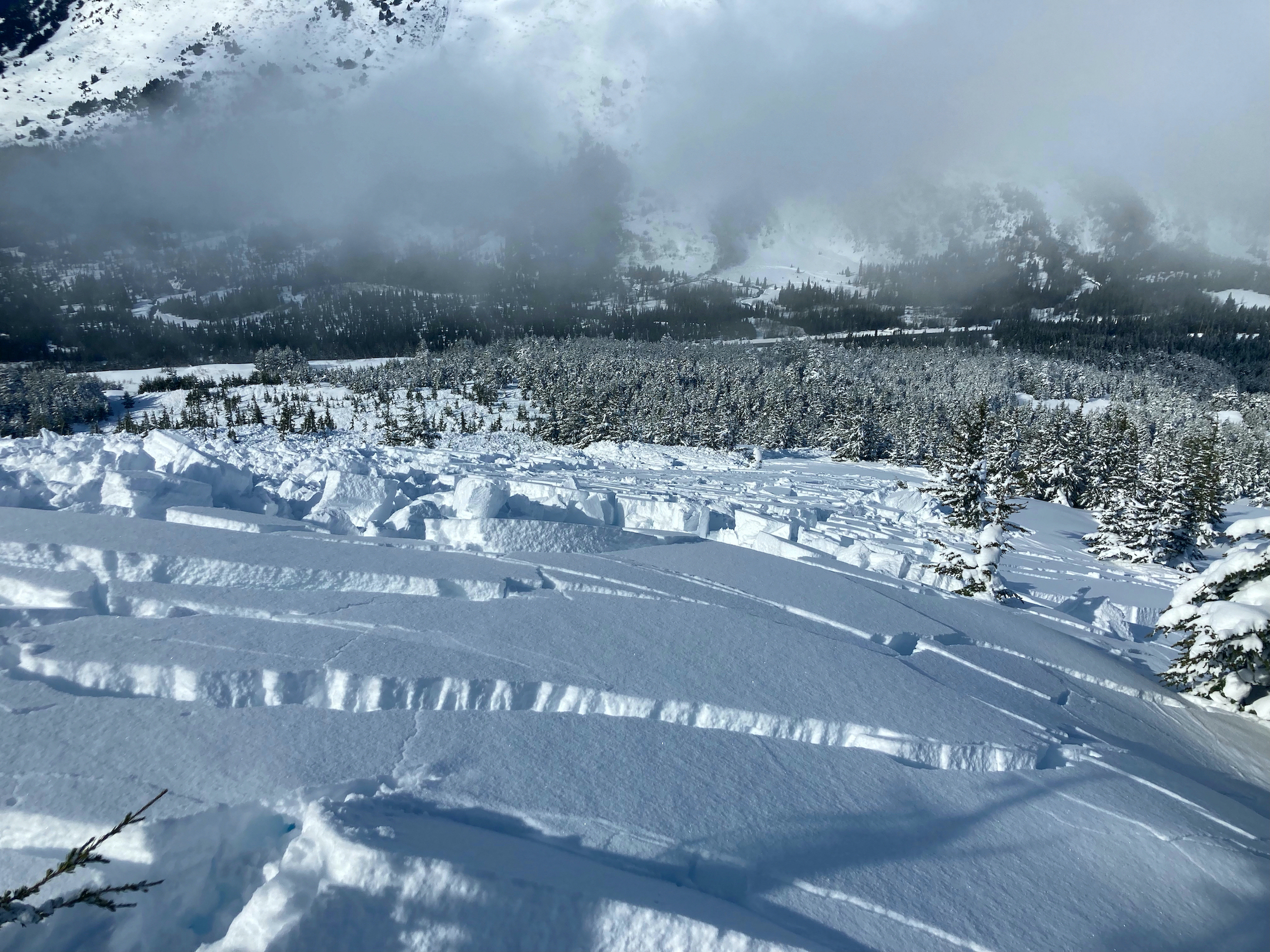
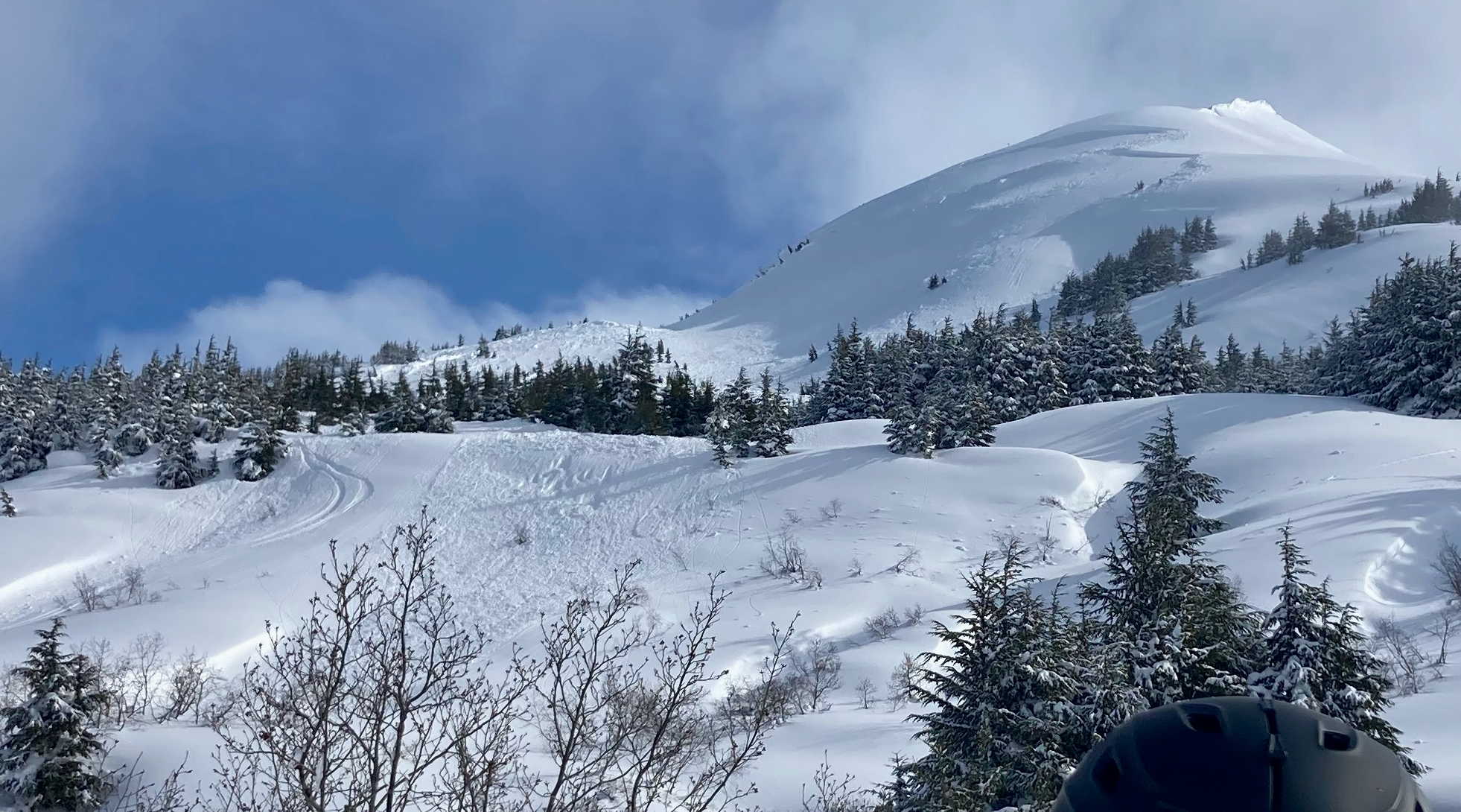
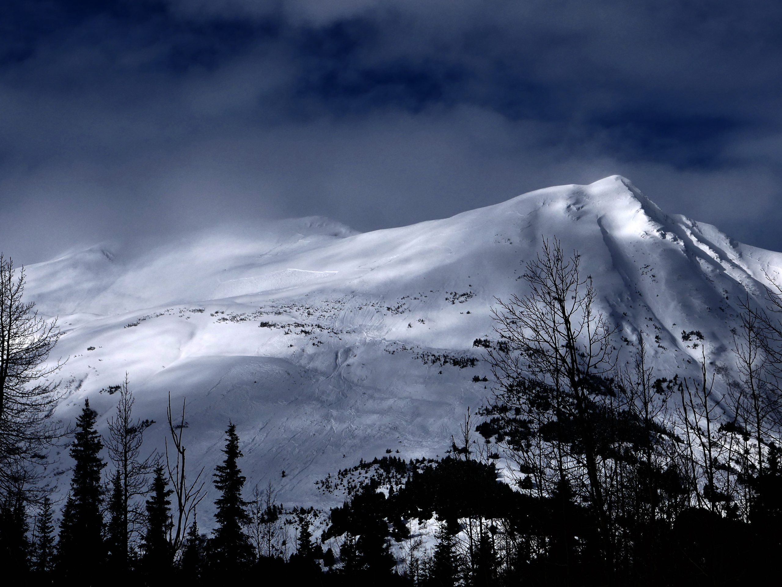
The avalanche danger is CONSIDERABLE above 1000′, and there are two big concerns for today. Winds are expected to increase during the day, making it likely a person will be able to trigger an avalanche where the wind is building sensitive slabs 1-2′ deep or deeper. The other, and potentially more dangerous, avalanche problem is the possibility of triggering a very large avalanche on multiple layers of surface hoar and near surface facets that were just buried 3-5′ deep by this week’s storm. Safe travel today will require sticking to lower slope angles and being mindful of the terrain above you, especially as winds continue to add stress to a sensitive snowpack through the day.

The danger is MODERATE below 1000′, where the snow is capped by a supportable crust and the main concern will be from large avalanches releasing in upper elevations and running far into runout zones.

Special Announcements

The National Weather Service has issued a Winter Weather Advisory starting at 7 p.m. tonight through 1 p.m. tomorrow for the next storm that will impact the area.

Sun, March 27th, 2022
Alpine
Above 2,500'
3 - Considerable
Avalanche risk
Treeline
1,000'-2,500'
3 - Considerable
Avalanche risk
Below Treeline
Below 1,000'
2 - Moderate
Avalanche risk
0 - No Rating
1 - Low
2 - Moderate
3 - Considerable
4 - High
5 - Extreme
Avalanche risk Avalanche risk Avalanche risk Avalanche risk Avalanche risk
Travel Advice Generally safe avalanche conditions. Watch for unstable snow on isolated terrain features. Heightened avalanche conditions on specific terrain features. Evaluate snow and terrain carefully; identify features of concern. Dangerous avalanche conditions. Careful snowpack evaluation, cautious route-finding, and conservative decision-making essential. Very dangerous avalanche conditions. Travel in avalanche terrain not recommended. Extraordinarily dangerous avalanche conditions. Avoid all avalanche terrain.
Likelihood of Avalanches Natural and human-triggered avalanches unlikely. Natural avalanches unlikely; human-triggered avalanches possible. Natural avalanches possible; human-triggered avalanches likely. Natural avalanches likely; human-triggered avalanches very likely. Natural and human-triggered avalanches certain.
Avalanche Size and Distribution Small avalanches in isolated areas or extreme terrain. Small avalanches in specific areas; or large avalanches in isolated areas. Small avalanches in many areas; or large avalanches in specific areas; or very large avalanches in isolated areas. Large avalanches in many areas; or very large avalanches in specific areas. Very large avalanches in many areas.
Recent Avalanches

Pete’s North: Skiers triggered a large avalanche remotely from a shallow slope angle, propagating several hundred feet wide and about 3′ deep. The skiers were transitioning from skinning to skiing, and had just stepped out of their skis and into the soft snow when they triggered the avalanche. They were out of the avalanche path, but it ran very close to where they were standing. More details in this observation.

Looking down at the avalanche near the point where it was triggered. Photo submitted anonymously. 03.26.2022.

Looking up at the entire path. The avalanche took out most the slope and ran far into the lower angle trees. Photo submitted anonymously. 03.26.2022.

Avalanche Problem 1
  • Wind Slabs
    Wind Slabs
  • Certain
    Very Likely
    Likely
    Possible
    Unlikely
    Likelihood
  • Historic (D4-5)
    Very Large (D3)
    Large (D2)
    Small (D1)
    Size
Wind Slabs
Wind Slab avalanches are the release of a cohesive layer of snow (a slab) formed by the wind. Wind typically transports snow from the upwind sides of terrain features and deposits snow on the downwind side. Wind slabs are often smooth and rounded and sometimes sound hollow, and can range from soft to hard. Wind slabs that form over a persistent weak layer (surface hoar, depth hoar, or near-surface facets) may be termed Persistent Slabs or may develop into Persistent Slabs.

Likelihood of Avalanches
Terms such as "unlikely", "likely", and "certain" are used to define the scale, with the chance of triggering or observing avalanches increasing as we move up the scale. For our purposes, "Unlikely" means that few avalanches could be triggered in avalanche terrain and natural avalanches are not expected. "Certain" means that humans will be able to trigger avalanches on many slopes, and natural avalanches are expected.

Size of Avalanches
Avalanche size is defined by the largest potential avalanche, or expected range of sizes related to the problem in question. Assigned size is a qualitative estimate based on the destructive classification system and requires specialists to estimate the harm avalanches may cause to hypothetical objects located in the avalanche track (AAA 2016, CAA 2014). Under this schema, "Small" avalanches are not large enough to bury humans and are relatively harmless unless they carry people over cliffs or through trees or rocks. Moving up the scale, avalanches become "Large" enough to bury, injure, or kill people. "Very Large" avalanches may bury or destroy vehicles or houses, and "Historic" avalanches are massive events capable of altering the landscape.

Signal Word Size (D scale) Simple Descriptor
Small 1 Unlikely to bury a person
Large 2 Can bury a person
Very Large 3 Can destroy a house
Historic 4 & 5 Can destroy part or all of a village
More info at Avalanche.org

Winds are picking up ahead of the next round of snow, which will make it easy for a person to trigger avalanches near the surface in fresh wind slabs that form today. These avalanches will be anywhere from a few inches to several feet deep, and there is the potential that a relatively small wind slab avalanche can step down to make a very large avalanche on weak layers that were just buried 3-5′ deep by this week’s storm. More on that in problem 2 below. With the impressive storm totals from last week, there is plenty of snow to be blown into a new round of sensitive slabs, and with sustained wind speeds expected to slowly climb to 20-30 mph during the day, it is possible we will see natural avalanche activity by this afternoon. Fresh slabs will be forming in the typical suspect terrain features- near ridgelines, convex rolls, and steep gullies. Given the dangerous setup we are dealing with, we need to approach terrain very cautiously today. This means sticking to low slope angles and being mindful of the terrain above you. Because of the potential for very large avalanches, this is not your typical wind slab problem.

The system that is moving in today is expected to bring 8-12″ snow to Girdwood, 12-18″ snow to Turnagain Pass, and 2′ or more to Portage and Placer by Tuesday morning. Expect dangerous avalanche conditions for the next few days, and be sure to stay tuned for more info.

Here comes the next round of snow. Precipitation is expected to pick up tonight into Tuesday. Graphic courtesy of NWS Anchorage. 03.26.2022

Avalanche Problem 2
  • Persistent Slabs
    Persistent Slabs
  • Certain
    Very Likely
    Likely
    Possible
    Unlikely
    Likelihood
  • Historic (D4-5)
    Very Large (D3)
    Large (D2)
    Small (D1)
    Size
Persistent Slabs
Persistent Slab avalanches are the release of a cohesive layer of snow (a slab) in the middle to upper snowpack, when the bond to an underlying persistent weak layer breaks. Persistent layers include: surface hoar, depth hoar, near-surface facets, or faceted snow. Persistent weak layers can continue to produce avalanches for days, weeks or even months, making them especially dangerous and tricky. As additional snow and wind events build a thicker slab on top of the persistent weak layer, this avalanche problem may develop into a Deep Persistent Slab.

Likelihood of Avalanches
Terms such as "unlikely", "likely", and "certain" are used to define the scale, with the chance of triggering or observing avalanches increasing as we move up the scale. For our purposes, "Unlikely" means that few avalanches could be triggered in avalanche terrain and natural avalanches are not expected. "Certain" means that humans will be able to trigger avalanches on many slopes, and natural avalanches are expected.

Size of Avalanches
Avalanche size is defined by the largest potential avalanche, or expected range of sizes related to the problem in question. Assigned size is a qualitative estimate based on the destructive classification system and requires specialists to estimate the harm avalanches may cause to hypothetical objects located in the avalanche track (AAA 2016, CAA 2014). Under this schema, "Small" avalanches are not large enough to bury humans and are relatively harmless unless they carry people over cliffs or through trees or rocks. Moving up the scale, avalanches become "Large" enough to bury, injure, or kill people. "Very Large" avalanches may bury or destroy vehicles or houses, and "Historic" avalanches are massive events capable of altering the landscape.

Signal Word Size (D scale) Simple Descriptor
Small 1 Unlikely to bury a person
Large 2 Can bury a person
Very Large 3 Can destroy a house
Historic 4 & 5 Can destroy part or all of a village
More info at Avalanche.org

We are still documenting the widespread cycle of very large natural avalanches from this week’s storm, which brought 3-5′ of snow to our advisory area, burying multiple weak layers of surface hoar and near surface facets. A lot of the crowns from that cycle have been blown in or buried in more snow, but some of the crowns we were still able to see were over a mile wide, and debris piles had fully grown trees in them. We have seen the potential size of avalanches this snowpack can make, and it is nothing to mess with. As winds pick up today, the weak layers that were buried over the past week will once again experience a fresh load, pushing them towards their breaking point.

As mentioned above, one way to trigger an avalanche on one of these deeper weak layers today will be by triggering a smaller wind slab that steps down to make a bigger avalanche. It will also be possible to trigger a large avalanche on slopes that aren’t getting wind loaded, since we already have a thick slab sitting on top of this weak layer. With a deeply buried weak layer like the one(s) we are dealing with, it is not uncommon to see a person trigger an avalanche even after there have been multiple tracks on a slope. As seen in the avalanche from Pete’s North yesterday, it is also possible to trigger very large avalanches remotely- from above, below, or adjacent to the slope that avalanches.

The current setup has the potential for very large and destructive avalanches, and we need to be very cautious with terrain choices today. As mentioned in problem 1 above, stick to lower slope angles today, and be mindful of the terrain above you.

This crown at the head of the Lynx Creek drainage was over a mile wide. If you look closely you can see it spans the entire frame of this photo. Avalanches of similar size are still possible today. 03.26.2022

Click Here if the video below does not load in your browser.


Weather
Sun, March 27th, 2022

Yesterday: Skies were mostly cloudy with some extended periods of sun, and some areas seeing brief periods of heavy snowfall. Winds were light out of the east at 5-10 mph, and temperatures were in the upper 20’s to upper 30’s F during the day before dropping 20-30 F overnight.

Today: We will see some light snow showers under mostly cloudy skies today with a trace to 2″ accumulation during the day. Winds are expected to increase during the day, with sustained speeds of 10 mph this morning picking up to 30 mph by the afternoon. Highs will be in the mid 20’s to mid 30’s F, and overnight lows are expected to drop back down to the low 20’s F. Snow should make it down to sea level today through tonight before creeping up later tomorrow.

Tomorrow: Heavy snowfall returns tonight and tomorrow, with accumulations of around a foot by the end of the day tomorrow for Girdwood and Turnagain Pass, 2-4″ in Summit and 2′ possible in Portage and Placer. The snow line is expected to stay down to sea level for most of the day tomorrow, but it may creep up to 200-400′ in the afternoon. Easterly winds are expected to stay strong through tonight into tomorrow, with sustained speeds of 35-45 mph and gusts of 40-50.

PRECIPITATION 24-hour data (6am – 6am)

Temp Avg (F) Snow (in) Water (in) Snow Depth (in)
Center Ridge (1880′) 32 0 0.2 119
Summit Lake (1400′) 30 0 0 43
Alyeska Mid (1700′) 33 0 0 N/A

RIDGETOP 24-hour data (6am – 6am)

Temp Avg (F) Wind Dir Wind Avg (mph) Wind Gust (mph)
Sunburst (3812′) 19 ENE 8 32
Seattle Ridge (2400′) 25 N/A N/A N/A

Seattle Ridge anemometer is rimed over and not reporting.

Observations
Recent Observations for Turnagain Pass
Date Region Location
03/27/24 Turnagain Observation: Tincan Trees
03/26/24 Turnagain Observation: Cornbiscuit
03/25/24 Turnagain Observation: Tincan
03/22/24 Turnagain Avalanche: Magnum Northwest Aspect
03/21/24 Turnagain Observation: Sunburst
03/21/24 Turnagain Observation: Tincan Proper North Aspect
03/20/24 Turnagain Avalanche: Seattle Creek Drainage
03/19/24 Turnagain Observation: Tincan CFR
03/18/24 Turnagain Avalanche: Tincan – Eddies – Seattle Ridge
03/18/24 Turnagain Observation: Tincan
Riding Areas

The riding areas page has moved. Please click here & update your bookmarks.


Subscribe to Turnagain Pass
Avalanche Forecast by Email

This is a general backcountry avalanche advisory issued for Turnagain Arm with Turnagain Pass as the core advisory area. This advisory does not apply to highways, railroads or operating ski areas.