Turnagain Pass |
Archives |
The avalanche danger is MODERATE today. The outflow (northwest) wind event that started Saturday night will continue through the day. Human triggered wind slabs 1-2′ thick are possible in steep wind loaded terrain. Watch for blowing snow and wind effect. Late in the the day there is a chance of small wet loose avalanches on steep solar aspects at lower elevations. Give cornices a wide berth. Evaluate snow and terrain carefully.
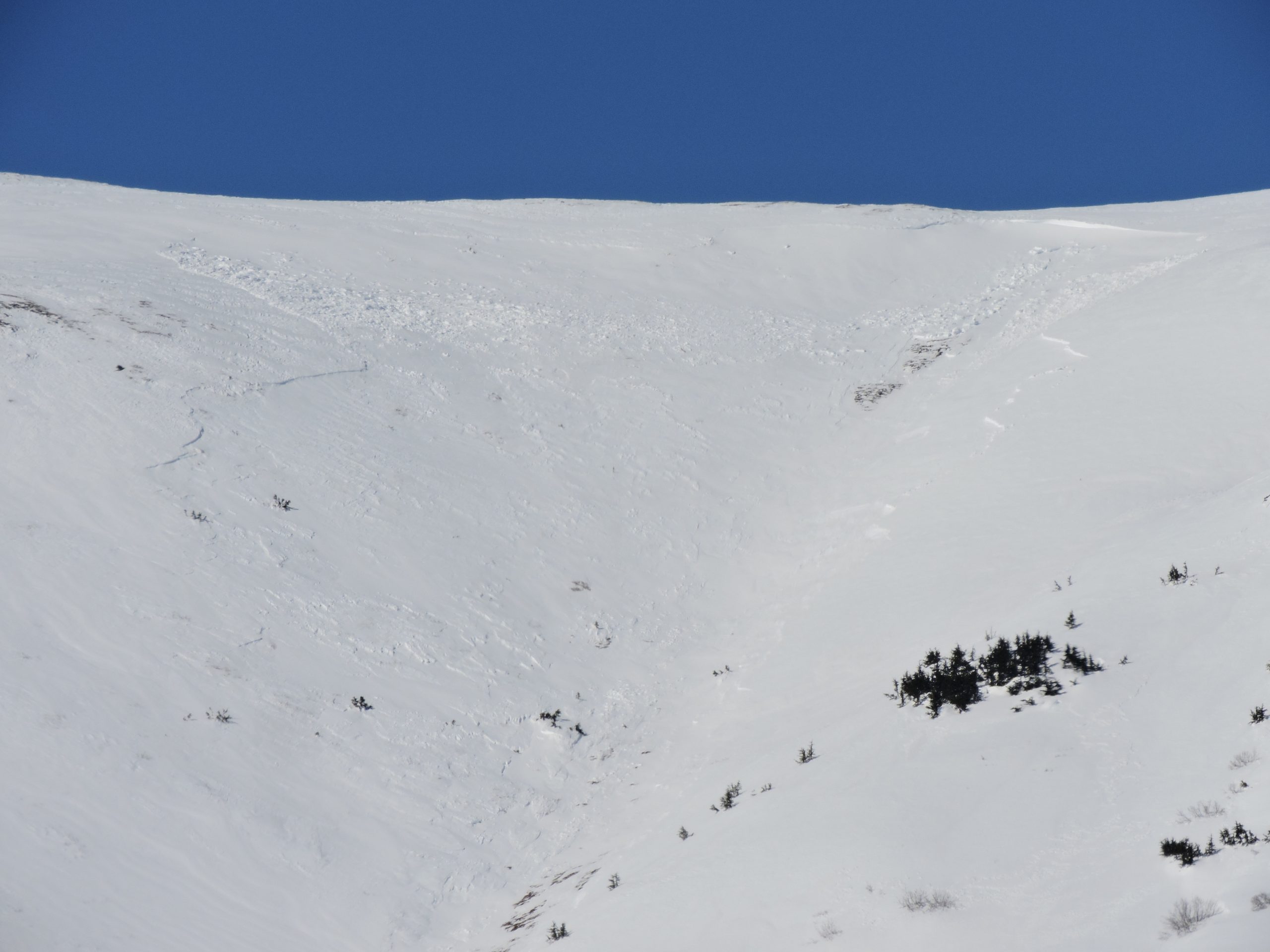
SUMMIT LAKE: Natural avalanches were observed in Summit Lake yesterday. Continued active loading could trigger avalanches today and human triggered wind slabs are likely. A shallower snowpack with weak snow in the mid and base of the pack exists from the southern end of Turnagain Pass south to Summit Lake. Extra caution is advised.
PORTAGE VALLEY/Byron Glacier Trail: Strong wind will increase the avalanche danger in this zone. Avoid avalanche runout zones such as the Byron Glacier hiking trail up to the ice caves
***Roof Avalanches: Roofs may still shed remaining snow!
Travel Advice | Generally safe avalanche conditions. Watch for unstable snow on isolated terrain features. | Heightened avalanche conditions on specific terrain features. Evaluate snow and terrain carefully; identify features of concern. | Dangerous avalanche conditions. Careful snowpack evaluation, cautious route-finding, and conservative decision-making essential. | Very dangerous avalanche conditions. Travel in avalanche terrain not recommended. | Extraordinarily dangerous avalanche conditions. Avoid all avalanche terrain. |
Likelihood of Avalanches | Natural and human-triggered avalanches unlikely. | Natural avalanches unlikely; human-triggered avalanches possible. | Natural avalanches possible; human-triggered avalanches likely. | Natural avalanches likely; human-triggered avalanches very likely. | Natural and human-triggered avalanches certain. |
Avalanche Size and Distribution | Small avalanches in isolated areas or extreme terrain. | Small avalanches in specific areas; or large avalanches in isolated areas. | Small avalanches in many areas; or large avalanches in specific areas; or very large avalanches in isolated areas. | Large avalanches in many areas; or very large avalanches in specific areas. | Very large avalanches in many areas. |
Signal Word | Size (D scale) | Simple Descriptor |
Small | 1 | Unlikely to bury a person |
Large | 2 | Can bury a person |
Very Large | 3 | Can destroy a house |
Historic | 4 & 5 | Can destroy part or all of a village |
The northwest winds (outflow) started ramping up Saturday night, were sustained throughout the day yesterday, blowing 15-25 mph with gusts into the 40s and are forecast to continue today. With the 2-8″ of snow from Saturday available for transport, blowing snow was observed throughout the forecast area and wind effect was notable. A few small naturals were observed through Turnagain and Portage. Today with continuing winds it will be important to pay attention to active loading, wind loading patterns in terrain and wind hardened surface conditions. Triggering a wind slab in steep loaded terrain will be possible. Look for cracking and areas with hard snow over soft snow. The St. Patrick’s Day surface hoar may make these even more touchy. Remember the northwest winds create some funky loading patterns as they are visibly channeled through Turnagain Pass from the south but are picked up on the Sunburst weather station blowing from the northwest. Areas like Crow Pass, upper elevation terrain in both Portage and Placer valleys and the south end of Turnagain Pass to Summit Lake tend to be impacted even more by this wind direction. As noted below in additional concerns Summit Lake had some large natural wind triggered avalanches yesterday.
Signal Word | Size (D scale) | Simple Descriptor |
Small | 1 | Unlikely to bury a person |
Large | 2 | Can bury a person |
Very Large | 3 | Can destroy a house |
Historic | 4 & 5 | Can destroy part or all of a village |
Low elevation solar aspects could heat up enough to soften surface crusts by the late afternoon. If and when this happens, triggering small wet sluffs on steep sunny slopes will be possible, especially near rocky areas.
In areas with a thinner snowpack, from the southern end of the forecast zone to Summit lake, weak snow (both surface hoar and facets) is buried 1-3′ below the surface. The northwest winds impact this region more and can rapidly load slopes. Yesterday natural wind triggered avalanches were observed in Summit Lake and some looked to have stepped down in places to the facets. The continuing outflow winds today could trigger more avalanches and make human triggered avalanches likely. Watch for blowing snow and choose terrain carefully.
Yesterday: Skies were clear with temperatures in the low to mid 30°Fs at lower elevations and teens to mid 20°Fs at upper elevations. Winds were northwesterly 15-25 mph with gusts into the 40s and higher at some locations. Overnight skies remained clear and temperatures were in the high teens and mid 20°Fs in the Alpine and mid 30°Fs to high 20°Fs at lower elevations. The northwest winds continued to be moderate and gusty.
Today: Sunshine and clear skies are in the forecast with increasing clouds later in the day. Temperatures will be in high 30°Fs at lower elevations and mid to high 20°Fs at upper elevations. The northwest winds will continue during the day easing off in the evening. Overnight skies will be partly to mostly cloudy with temperatures in the 20°Fs.
Tomorrow: Partly sunny skies with temperatures in the high 20°Fs to high 30°Fs. Winds will be mostly light and westerly. Skies will become mostly cloudy in overnight and temperatures will be in the high 20°Fs.
PRECIPITATION 24-hour data (6am – 6am)
Temp Avg (F) | Snow (in) | Water (in) | Snow Depth (in) | |
---|---|---|---|---|
Center Ridge (1880′) | 28 | 0 | 0 | 68 |
Summit Lake (1400′) | 27 | 0 | 0 | 32 |
Alyeska Mid (1700′) | 26 | 0 | 0 | 78 |
RIDGETOP 24-hour data (6am – 6am)
Temp Avg (F) | Wind Dir | Wind Avg (mph) | Wind Gust (mph) | |
---|---|---|---|---|
Sunburst (3812′) | 17 | NW | 12 | 36 |
Seattle Ridge (2400′) | 24 | NW | 14 | 39 |
Date | Region | Location | Observer |
---|---|---|---|
10/27/24 | Turnagain | Observation: Tincan | Michael Kerst |
10/21/24 | Turnagain | Observation: Turnagain Pass Road Observation | Trevor Clayton |
10/19/24 | Turnagain | Observation: Tincan – Below Todds Run | Andy Moderow |
10/18/24 | Turnagain | Observation: Taylor Pass | Eli Neuffer |
10/15/24 | Turnagain | Observation: Tincan Common | John Sykes Forecaster |
10/14/24 | Turnagain | Avalanche: Tincan | CNFAC Staff |
05/13/24 | Turnagain | Observation: Eddie’s, Sunburst, Seattle, Cornbiscuit, Pete’s South | H Thamm |
05/13/24 | Turnagain | Observation: Turnagain Pass non-motorized side | Amy Holman |
05/12/24 | Turnagain | Observation: Warm up Bowl | Tony Naciuk |
05/07/24 | Turnagain | Observation: Turnagain Pass Wet Slabs | A S |
The riding areas page has moved. Please click here & update your bookmarks.
Subscribe to Turnagain Pass
Avalanche Forecast by Email