Turnagain Pass RSS

Archives
ARCHIVED - Forecasts expire after 24 hours.
Issued
Sat, March 20th, 2021 - 7:00AM
Expires
Sun, March 21st, 2021 - 7:00AM
Forecaster
Wendy Wagner
Avalanche risk The Bottom Line

The avalanche danger is MODERATE at all elevations. Easterly winds are on the rise today and triggering a fresh wind slab up to a foot deep is possible. These are most likely to form along ridgelines and in cross-loaded gullies above 2,500′ or in open steep slopes in the trees that see any active wind loading. Additionally, there is still a lingering chance a person could trigger a slab avalanche 1-3′ deep at any elevation due to buried weak layers.

SUMMIT LAKE/LOST LAKE/SNUG/SEWARD:  Strong northwest winds over the past two days coupled with strong easterly winds today have created widespread wind effect and wind slab development in these areas. Be sure to avoid slopes with recent or active wind loading.

Special Announcements

Headed to Hatcher Pass? Be sure to check out the Hatcher Pass Avalanche Center’s Saturday morning forecast!!

Swing by the Turnagain Pass motorized parking lot TODAY and say hi to CNFAIC forecasters, bring your avalanche questions and check out the latest and greatest snowmachines. Longtime CNFAIC supporter Alaska Mining and Diving Supply will be hosting a demo day. AMDS has provided the avalanche center with snowmachines through the years and this partnership is vital. Look for us near the AMDS trailer!

Sat, March 20th, 2021
Alpine
Above 2,500'
2 - Moderate
Avalanche risk
Treeline
1,000'-2,500'
2 - Moderate
Avalanche risk
Below Treeline
Below 1,000'
2 - Moderate
Avalanche risk
0 - No Rating
1 - Low
2 - Moderate
3 - Considerable
4 - High
5 - Extreme
Avalanche risk Avalanche risk Avalanche risk Avalanche risk Avalanche risk
Travel Advice Generally safe avalanche conditions. Watch for unstable snow on isolated terrain features. Heightened avalanche conditions on specific terrain features. Evaluate snow and terrain carefully; identify features of concern. Dangerous avalanche conditions. Careful snowpack evaluation, cautious route-finding, and conservative decision-making essential. Very dangerous avalanche conditions. Travel in avalanche terrain not recommended. Extraordinarily dangerous avalanche conditions. Avoid all avalanche terrain.
Likelihood of Avalanches Natural and human-triggered avalanches unlikely. Natural avalanches unlikely; human-triggered avalanches possible. Natural avalanches possible; human-triggered avalanches likely. Natural avalanches likely; human-triggered avalanches very likely. Natural and human-triggered avalanches certain.
Avalanche Size and Distribution Small avalanches in isolated areas or extreme terrain. Small avalanches in specific areas; or large avalanches in isolated areas. Small avalanches in many areas; or large avalanches in specific areas; or very large avalanches in isolated areas. Large avalanches in many areas; or very large avalanches in specific areas. Very large avalanches in many areas.
Recent Avalanches

There was one avalanche reported yesterday. It was a skier triggered shallow, but wide, wind slab on the SW face of Cornbiscuit Ridge around 2,700′. Slab was reported at 4″ deep, 300′ wide and running 400′. Skier was able to ski off slab.

Shallow but wide wind slab triggered on the SW face of Cornbiscuit Ridge yesterday. 3.19.21. Russell Johanson.

Avalanche Problem 1
  • Wind Slabs
    Wind Slabs
  • Certain
    Very Likely
    Likely
    Possible
    Unlikely
    Likelihood
  • Historic (D4-5)
    Very Large (D3)
    Large (D2)
    Small (D1)
    Size
Wind Slabs
Wind Slab avalanches are the release of a cohesive layer of snow (a slab) formed by the wind. Wind typically transports snow from the upwind sides of terrain features and deposits snow on the downwind side. Wind slabs are often smooth and rounded and sometimes sound hollow, and can range from soft to hard. Wind slabs that form over a persistent weak layer (surface hoar, depth hoar, or near-surface facets) may be termed Persistent Slabs or may develop into Persistent Slabs.

Likelihood of Avalanches
Terms such as "unlikely", "likely", and "certain" are used to define the scale, with the chance of triggering or observing avalanches increasing as we move up the scale. For our purposes, "Unlikely" means that few avalanches could be triggered in avalanche terrain and natural avalanches are not expected. "Certain" means that humans will be able to trigger avalanches on many slopes, and natural avalanches are expected.

Size of Avalanches
Avalanche size is defined by the largest potential avalanche, or expected range of sizes related to the problem in question. Assigned size is a qualitative estimate based on the destructive classification system and requires specialists to estimate the harm avalanches may cause to hypothetical objects located in the avalanche track (AAA 2016, CAA 2014). Under this schema, "Small" avalanches are not large enough to bury humans and are relatively harmless unless they carry people over cliffs or through trees or rocks. Moving up the scale, avalanches become "Large" enough to bury, injure, or kill people. "Very Large" avalanches may bury or destroy vehicles or houses, and "Historic" avalanches are massive events capable of altering the landscape.

Signal Word Size (D scale) Simple Descriptor
Small 1 Unlikely to bury a person
Large 2 Can bury a person
Very Large 3 Can destroy a house
Historic 4 & 5 Can destroy part or all of a village
More info at Avalanche.org

After a bout of sunshine and cold northwest winds yesterday, a round of patchy high clouds and stronger east winds are headed in for today (the first day of spring!). With only a chance for a few snow flurries, it will be the east winds, forecast to average 25-35mph along the ridges, that will be our main player.

The soft surface snow many people have been enjoying was hit by varying degrees of west and northwest winds for the last two days; today that snow will be hit from the east. Wind slabs, both new and older, are likely to be found on all aspects. While the older slabs should be on the more stubborn side, any fresh wind slab encountered today is likely to be touchier. Discerning new and old slabs might not be very easy. New slabs should be softer and show signs of cracking easier. With winds increasing through the day, watch where the active wind loading is taking place. As always, pay attention to stiffer snow over softer snow and where the snow feels ‘punchy’. Jumping on small test slopes or little rolls with wind loading is a good way to see if the snow wants to break and slide.

Keep in mind, wind slabs on steep southerly aspects could be sitting on an old buried sun crust and may pop out easier than expected. It is possible this was the case in the shallow, but wide, wind slabs from both Cornbiscuit yesterday and Tenderfoot on Thursday. Wind slabs on any aspect could also be sitting on weak faceted grains and/or buried surface hoar, making them easier to trigger and break wider than expected.

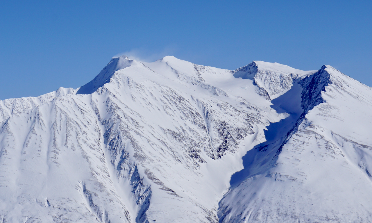
Snow transport by the northwest winds south of our forecast zone in the Lost Lake area. Transport like this was seen near Girdwood yesterday morning and south of Turnagain Pass. 

Avalanche Problem 2
  • Persistent Slabs
    Persistent Slabs
  • Certain
    Very Likely
    Likely
    Possible
    Unlikely
    Likelihood
  • Historic (D4-5)
    Very Large (D3)
    Large (D2)
    Small (D1)
    Size
Persistent Slabs
Persistent Slab avalanches are the release of a cohesive layer of snow (a slab) in the middle to upper snowpack, when the bond to an underlying persistent weak layer breaks. Persistent layers include: surface hoar, depth hoar, near-surface facets, or faceted snow. Persistent weak layers can continue to produce avalanches for days, weeks or even months, making them especially dangerous and tricky. As additional snow and wind events build a thicker slab on top of the persistent weak layer, this avalanche problem may develop into a Deep Persistent Slab.

Likelihood of Avalanches
Terms such as "unlikely", "likely", and "certain" are used to define the scale, with the chance of triggering or observing avalanches increasing as we move up the scale. For our purposes, "Unlikely" means that few avalanches could be triggered in avalanche terrain and natural avalanches are not expected. "Certain" means that humans will be able to trigger avalanches on many slopes, and natural avalanches are expected.

Size of Avalanches
Avalanche size is defined by the largest potential avalanche, or expected range of sizes related to the problem in question. Assigned size is a qualitative estimate based on the destructive classification system and requires specialists to estimate the harm avalanches may cause to hypothetical objects located in the avalanche track (AAA 2016, CAA 2014). Under this schema, "Small" avalanches are not large enough to bury humans and are relatively harmless unless they carry people over cliffs or through trees or rocks. Moving up the scale, avalanches become "Large" enough to bury, injure, or kill people. "Very Large" avalanches may bury or destroy vehicles or houses, and "Historic" avalanches are massive events capable of altering the landscape.

Signal Word Size (D scale) Simple Descriptor
Small 1 Unlikely to bury a person
Large 2 Can bury a person
Very Large 3 Can destroy a house
Historic 4 & 5 Can destroy part or all of a village
More info at Avalanche.org

As we have been talking about for nearly 10 days now, there are buried weak layers in the top 3 feet of the snowpack. These are facets and buried surface hoar. In lower elevation terrain, below 1,000′, they are associated with a crust and were responsible for a large avalanche triggered by a skier on Thursday (3/18, 3′ deep slab at an elevation of 600′ on an east aspect). On southerly slopes, some noteworthy collapses in the Girdwood area have been found around 2,000′ where facets sit around a buried sun crust about a foot down. In the higher elevation terrain these weak layers are surrounded by stiffer wind slabs in wind affected zones and softer snow in areas out of the wind effect. We have not seen these layers produce an avalanche in upper elevations for over a week now when they were reactive during the storm on 3/10.

All that said, how likely it is a person could trigger a large slab breaking in one of these weak layers is the million dollar question. Data is pointing to an unlikely chance in the Turnagain Pass area, but Girdwood seems to be a bit more suspect in the lower elevations (below 2,500′). As well as Summit Lake where the snowpack is shallower and collapsing has been reported there as well in the mid elevations. What to do with this information? As always, watch for signs of instability (whumpfing/collapsing), use good travel protocol, and think about terrain and the potential consequences.

Weather
Sat, March 20th, 2021

Yesterday:  Sunny skies were over the region. The cold northwest winds blew in the 5-15mph range with stronger gusts. Temperatures warmed from the single digits to 20F at lower elevations and the teens and the mid while remaining below 10F in high elevations.

Today:  High clouds are streaming in this morning as a low pressure spins to the south in the Gulf. There is a chance for a few snow flurries later this afternoon, but no accumulation is expected. Ridgetop winds turned easterly around midnight and have been increasing since. They are forecast to average 25-35mph this afternoon before slowing down later tonight. Temperatures will be a tad bit warmer, in the teens to 20F in parking lots and near 10F along ridgetops.

Tomorrow:  Sunshine returns for tomorrow and possibly into Monday. Ridgetop winds turn back northwesterly, as the low pressure passes us by, but look to remain light. Temperatures should be trending warmer, in the teens at the higher elevations and near 30F at sea level.

PRECIPITATION 24-hour data (6am – 6am)

Temp Avg (F) Snow (in) Water (in) Snow Depth (in)
Center Ridge (1880′) 12 0 0 112
Summit Lake (1400′) 7 0 0 46
Alyeska Mid (1700′) 11 0 0 116

RIDGETOP 24-hour data (6am – 6am)

Temp Avg (F) Wind Dir Wind Avg (mph) Wind Gust (mph)
Sunburst (3812′) 3 W->E 9 33*
Seattle Ridge (2400′) 10 NW->E 7 17*

*Wind gusts are from 6am this morning with increasing easterly winds.

Observations
Recent Observations for Turnagain Pass
Date Region Location
03/27/24 Turnagain Observation: Tincan Trees
03/26/24 Turnagain Observation: Cornbiscuit
03/25/24 Turnagain Observation: Tincan
03/22/24 Turnagain Avalanche: Magnum Northwest Aspect
03/21/24 Turnagain Observation: Sunburst
03/21/24 Turnagain Observation: Tincan Proper North Aspect
03/20/24 Turnagain Avalanche: Seattle Creek Drainage
03/19/24 Turnagain Observation: Tincan CFR
03/18/24 Turnagain Avalanche: Tincan – Eddies – Seattle Ridge
03/18/24 Turnagain Observation: Tincan
Riding Areas

The riding areas page has moved. Please click here & update your bookmarks.


Subscribe to Turnagain Pass
Avalanche Forecast by Email

This is a general backcountry avalanche advisory issued for Turnagain Arm with Turnagain Pass as the core advisory area. This advisory does not apply to highways, railroads or operating ski areas.