Turnagain Pass Avalanche Forecast RSS

Archives
ARCHIVED FORECAST - All forecasts expire after 24 hours from the posting date/time.
Issued
Sun, March 21st, 2021 - 7:00AM
Expires
Mon, March 22nd, 2021 - 7:00AM
Forecaster
Andrew Schauer
Avalanche risk The Bottom Line

The avalanche danger remains MODERATE today, as there is a lingering possibility of triggering an avalanche 1-3’ deep on weak snow buried earlier this month. The most likely places to find unstable snow will be in steep terrain with stiff snow at the surface. In addition to the persistent weak layers, light northwesterly winds may form thin but sensitive wind slabs that are not expected to be large, but could be easy to trigger. Safe travel today will require paying attention to surface conditions and avoiding steep slopes with stiff snow on top.

SNUG HARBOR/LOST LAKE/SEWARD: Stronger winds are once again expected closer to Seward, increasing the likelihood of wind slab avalanches. Extra caution is advised in the mountains around Snug Harbor, Lost Lake and Seward.

Thanks to our sponsors!
Sun, March 21st, 2021
Alpine
Above 2,500'
Moderate (2)
Avalanche risk
Treeline
1,000'-2,500'
Moderate (2)
Avalanche risk
Below Treeline
Below 1,000'
Moderate (2)
Avalanche risk
Alpine
Above 2,500'
Avalanche risk
Moderate (2)
Treeline
1,000'-2,500'
Avalanche risk
Moderate (2)
Below Treeline
Below 1,000'
Avalanche risk
Moderate (2)
Danger Scale:
No Rating (0)
Low (1)
Moderate (2)
Considerable (3)
High (4)
Extreme (5)
Avalanche Problem 1
  • Persistent Slabs
    Persistent Slabs
  • Almost Certain
    Very Likely
    Likely
    Possible
    Unlikely
    Likelihood
  • Historic (D4-5)
    Very Large (D3)
    Large (D2)
    Small (D1)
    Size
Persistent Slabs
Persistent Slab avalanches are the release of a cohesive layer of snow (a slab) in the middle to upper snowpack, when the bond to an underlying persistent weak layer breaks. Persistent layers include: surface hoar, depth hoar, near-surface facets, or faceted snow. Persistent weak layers can continue to produce avalanches for days, weeks or even months, making them especially dangerous and tricky. As additional snow and wind events build a thicker slab on top of the persistent weak layer, this avalanche problem may develop into a Deep Persistent Slab.

Likelihood of Avalanches
Terms such as "unlikely", "likely", and "certain" are used to define the scale, with the chance of triggering or observing avalanches increasing as we move up the scale. For our purposes, "Unlikely" means that few avalanches could be triggered in avalanche terrain and natural avalanches are not expected. "Certain" means that humans will be able to trigger avalanches on many slopes, and natural avalanches are expected.

Size of Avalanches
Avalanche size is defined by the largest potential avalanche, or expected range of sizes related to the problem in question. Assigned size is a qualitative estimate based on the destructive classification system and requires specialists to estimate the harm avalanches may cause to hypothetical objects located in the avalanche track (AAA 2016, CAA 2014). Under this schema, "Small" avalanches are not large enough to bury humans and are relatively harmless unless they carry people over cliffs or through trees or rocks. Moving up the scale, avalanches become "Large" enough to bury, injure, or kill people. "Very Large" avalanches may bury or destroy vehicles or houses, and "Historic" avalanches are massive events capable of altering the landscape.

Signal Word Size (D scale) Simple Descriptor
Small 1 Unlikely to bury a person
Large 2 Can bury a person
Very Large 3 Can destroy a house
Historic 4 & 5 Can destroy part or all of a village
More info at Avalanche.org

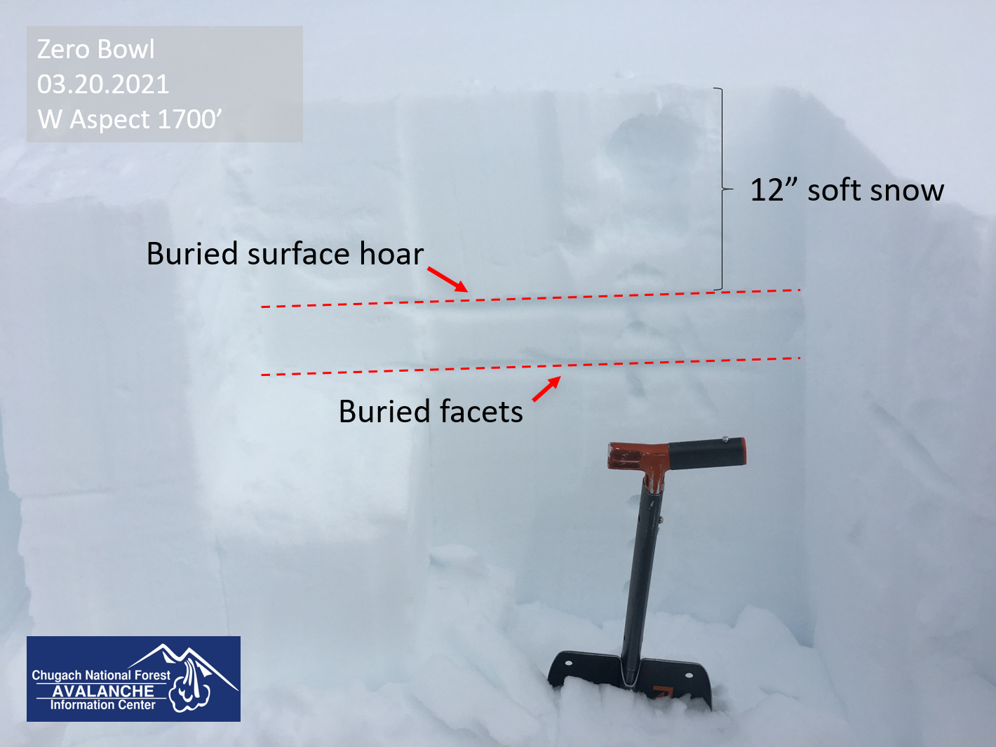
Our main concern today is the lingering potential to trigger an avalanche 1-3’ deep on the layer of buried surface hoar and near-surface facets that were buried about two weeks ago. As we move further out from the last major loading event, these weak grain types are slowly gaining strength, becoming more stubborn and difficult to trigger. Although the likelihood for triggering these avalanches is decreasing, we still do not have the confidence to forget about this problem. The most likely place to run into trouble will be in terrain that has been recently wind-loaded, with relatively stiff snow sitting on top of relatively soft snow. It may also be a bit more sensitive on steep southerly aspects, where there are weak facets above and below a sun crust that formed earlier in the month. If you are trying to step out into steep terrain today, you can minimize your risk by being mindful of safe travel protocol:

  • Make sure only one person is exposed to steep terrain at a time. Regroup in safe zones out of the way of avalanche paths and runout zones.
  • Avoid steep slopes with terrain traps that will increase the consequences of triggering even a small avalanche.
  • Pay attention to warning signs of poor stability. This includes recent avalanche activity, cracks shooting out from your machine or feet, and collapsing or ‘whumpfing’.

Wind Slabs: Winds have shifted back to the northwest. With speeds expected to stay in the 5-15 mph range, we might see some smaller wind slabs forming today. Be on the lookout for signs of wind loading, and avoid steep slopes that are being actively loaded.

Sluffs: Steep slopes that have been sheltered from the wind have around a foot or more of loose snow sitting on top of firm surfaces. It will be easy to trigger dry loose avalanches today, and they can pick up enough volume and speed to carry a person. While it is unlikely they will be big enough to bury you, they can be dangerous if they drag you into terrain traps like cliffs, trees, rocks, or gullies.

Buried weak layers in the upper snowpack from a snowpit in Zero Bowl. 03.21.2021 

Weather
Sun, March 21st, 2021

Yesterday: Skies were cloudy with high temperatures in the low teens to upper 20’s F. Low temperatures were in the single digits to mid teens F, and all the way down to -8 F near Portage yesterday morning. Easterly winds were 5-15 mph at ridgetops with gusts to 33 mph. No precipitation was recorded.

Today: We are expecting mostly sunny skies as winds shift back to the northwest at 5-15 mph. High temperatures are expected in the upper teens to mid 20s F, with lows in the single digits to low teens F tonight. No precipitation is expected today.

Tomorrow: Winds are expected to be calm for most of the day, increasing slightly and shifting back to the east in the afternoon. Skies are expected to start out mostly sunny, with increasing cloud cover in the afternoon. High temperatures are expected to be in the upper teens to mid 20s F, and no precipitation is expected.

PRECIPITATION 24-hour data (6am – 6am)

Temp Avg (F) Snow (in) Water (in) Snow Depth (in)
Center Ridge (1880′) 21 0 0 112
Summit Lake (1400′) 17 0 0 45
Alyeska Mid (1700′) 20 0 0 115

RIDGETOP 24-hour data (6am – 6am)

Temp Avg (F) Wind Dir Wind Avg (mph) Wind Gust (mph)
Sunburst (3812′) 9 NE 10 33
Seattle Ridge (2400′) 13 SE 8 25
Observations
Recent Observations for Turnagain Pass
Date Region Location
05/22/23 Turnagain Avalanche: Tincan
05/12/23 Turnagain Avalanche: Tincan, Sunburst, Magnum, Cornbiscuit
05/07/23 Turnagain Observation: Tincan – Bear Tracks
05/05/23 Turnagain Observation: Seattle Ridge
05/02/23 Turnagain Observation: Cornbiscuit
05/02/23 Turnagain Observation: Seward Hwy Turnagain Pass
04/30/23 Turnagain Observation: Magnum
04/29/23 Turnagain Observation: Tincan
04/28/23 Turnagain Avalanche: Taylor Pass/Pastoral
04/28/23 Turnagain Avalanche: Tincan
Riding Areas
Updated Mon, May 15th, 2023

Status of riding areas across the Chugach NF is managed by the Glacier and Seward Ranger Districts, not avalanche center staff. Riding area information is posted as a public service to our users and updated based on snow depth and snow density to prevent resource damage at trailhead locations. Riding area questions contact: mailroom_r10_chugach@fs.fed.us

Area Status Weather & Riding Conditions
Glacier District
Johnson Pass
Closed
Closed May 15.
Placer River
Closed
Closed May 15.
Skookum Drainage
Closed
Will close to motorized use on April 1, 2023 per the National Forest Plan.
Turnagain Pass
Open
Chugach NF staff will be assessing daily after May 15th. Please keep machines on the snow and avoid brown spots to keep this area open as long as possible.
Twentymile
Closed
Scheduled closure May 1.
Seward District
Carter Lake
Closed
Scheduled closure May 1.
Lost Lake Trail
Closed
Scheduled closure May 1.
Primrose Trail
Closed
Scheduled closure May 1.
Resurrection Pass Trail
Closed
Closed to motorized use for the 2022/23 winter season per Forest Plan. Open next season.
Snug Harbor
Closed
Extended opening until May 15.
South Fork Snow River Corridor
Closed
Scheduled closure May 1.
Summit Lake
Closed
Scheduled closure May 1.

Subscribe to Turnagain Pass
Avalanche Forecast by Email

This is a general backcountry avalanche advisory issued for Turnagain Arm with Turnagain Pass as the core advisory area. This advisory does not apply to highways, railroads or operating ski areas.