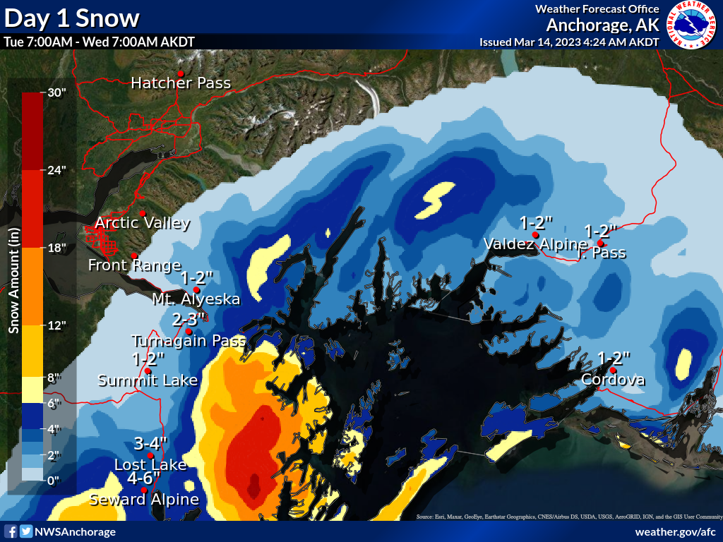
Turnagain Pass Avalanche Forecast RSS

Archives
ARCHIVED FORECAST - All forecasts expire after 24 hours from the posting date/time.
Issued
Tue, March 14th, 2023 - 7:00AM
Expires
Wed, March 15th, 2023 - 7:00AM
Forecaster
Andrew Schauer
Avalanche risk The Bottom Line

The avalanche danger will be LOW for most of the day, rising to MODERATE this evening as an approaching storm begins to impact our area. Conditions are expected to start out generally stable, but the avalanche danger will be on the rise later in the day as the weather picks up. As always, maintain safe travel protocol while you are out today, and be aware of increasing danger if the storm arrives sooner than expected.

PETE’S NORTH to JOHNSON PASS: The snowpack in this southern corner of our advisory area has a weak layer buried around 1-2′ deep that is still making it possible to trigger a large avalanche. If you plan to get out in this zone, be sure to evaluate the snow and terrain carefully before committing to steep slopes.

SUMMIT LAKE: The snowpack in the Summit Lake area is generally thinner and weaker than our core advisory area. Large human-triggered avalanches remain possible, which requires a more cautious mindset while choosing terrain.

Special Announcements

Turnagain Pass Avalanche Awareness Day – this Saturday!

On March 18th swing by the Turnagain Pass moto lot on your way to or from your backcountry ride or ski!! Test your beacon skills, chow down on hot dogs, and bring your questions for CNFAIC forecasters. The Alaska Avalanche School will be there along with a chance to demo snowmachines from Alaska Mining and Diving Supply and Anchorage Yamaha and Polaris. More details HERE

Thanks to our sponsors!
Tue, March 14th, 2023
Alpine
Above 2,500'
Low (1)
Avalanche risk
Treeline
1,000'-2,500'
Low (1)
Avalanche risk
Below Treeline
Below 1,000'
Low (1)
Avalanche risk
Alpine
Above 2,500'
Avalanche risk
Low (1)
Treeline
1,000'-2,500'
Avalanche risk
Low (1)
Below Treeline
Below 1,000'
Avalanche risk
Low (1)
Danger Scale:
No Rating (0)
Low (1)
Moderate (2)
Considerable (3)
High (4)
Extreme (5)
Recent Avalanches

Yesterday skiers reported a small natural avalanche on the Eddie’s Headwall. It looks like it may have been triggered by a falling cornice, and is probably a few days old. More details in this observation.

Photo of the Eddie’s Headwall, taken yesterday. The avalanche looks to be a few days old. Photo: Eric Steinfort, 03.13.2023

Avalanche Problem 1
  • Normal Caution
    Normal Caution
Normal Caution
Normal Caution means triggering an avalanche is unlikely but not impossible.
More info at Avalanche.org

The biggest factor driving the avalanche danger today is the timing of the approaching storm. It is looking like we won’t see very much precipitation until shortly before sunset today, which means the avalanche conditions should stay generally safe for most of the day. It will be important to pay attention to changing conditions as the weather picks up, and look out for increasing avalanche danger if the storm arrives sooner than expected.

Until it starts snowing, the main thing to watch out for will be small avalanches in isolated upper-elevation terrain. It is important to remember that although the danger is low, it is not impossible to trigger an avalanche. With a few hours of gusty winds yesterday afternoon, there may be some lurking pockets of reactive wind slabs. Stay smart with your travel habits- only exposing one person at a time to steep terrain and watching partners from safe spots out of avalanche runout zones. With deteriorating weather conditions expected today, it is probably a good idea to plan on getting out of the mountains a little earlier so you don’t get stuck in an uncomfortable situation as the storm ramps up and avalanche danger starts to rise.

It’s not much, but it is something! Snowfall is expected to start this afternoon and continue through Wednesday. There is high uncertainty with timing, and some areas may see higher snow totals. Be on the lookout for increasing danger as the storm ramps up. Graphic courtesy of NWS Anchorage. 03.14.2023

Additional Concern
  • Persistent Slabs
    Persistent Slabs
Persistent Slabs
Persistent Slab avalanches are the release of a cohesive layer of snow (a slab) in the middle to upper snowpack, when the bond to an underlying persistent weak layer breaks. Persistent layers include: surface hoar, depth hoar, near-surface facets, or faceted snow. Persistent weak layers can continue to produce avalanches for days, weeks or even months, making them especially dangerous and tricky. As additional snow and wind events build a thicker slab on top of the persistent weak layer, this avalanche problem may develop into a Deep Persistent Slab.
More info at Avalanche.org

We are still concerned with the possibility of triggering a larger avalanche on a layer of weak facets buried about a foot deep down in the southern edge of our forecast area. This layer is most problematic between Pete’s North and Johnson Pass, and was the culprit in a large skier-triggered avalanche last Monday (3/6). These stubborn persistent weak layers can be difficult to predict, so the best way to manage them is by avoiding steep slopes in this area.

Weather
Tue, March 14th, 2023

Yesterday: Skies were mostly sunny with a few clouds moving in later in the day. Winds were 5-10 mph out of the west for most of the day, with a few hours in the afternoon of speeds around 10-15 and gusts as high as 30 mph on Max’s. Portage recorded stronger easterly to northeasterly winds at around 5-15 mph with gusts around 25 mph. Temperatures reached the low to mid 20’s at lower elevations, staying in the single digits to low teens near ridgetops during the day, and dropped down to single digits above and below zero overnight. No precipitation was recorded yesterday.

Today: A pattern change is underway as a low pressure system in the Gulf brings increasing cloud cover and winds switching back to the east at 5-10 mph with gusts of 10-20 mph. The weather is looking to get more active late in the afternoon, with increasing winds and snowfall expected to start around 4 pm. We will likely only see a trace to 2” snow during daylight hours today, with another 2-4” possible tonight. Precipitation during this storm is expected to be spotty and difficult to predict, so some areas may see more than double those precipitation totals. Temperatures are expected to get into the mid to upper teens F during the day before dropping slightly to the low to mid teens early tonight. It is looking like snow line should stay down to sea level for this first round of precipitation.

Tomorrow: Snowfall should continue tonight into tomorrow, with another 1-2” likely during the day tomorrow. Easterly winds are expected to pick up tonight, blowing 15-25 mph with gusts of 20-30 before backing off slightly during the day tomorrow. Skies should be mostly cloudy during the day and high temperatures are expected to be in the low to mid 20’s F with lows in the low to mid teens F.

PRECIPITATION 24-hour data (6am – 6am)

Temp Avg (F) Snow (in) Water (in) Snow Depth (in)
Center Ridge (1880′) 16 0 0 64
Summit Lake (1400′) 13 0 0 37
Alyeska Mid (1700′) 16 0 0 64
Bear Valley – Portage (132′) 15 0 0

RIDGETOP 24-hour data (6am – 6am)

Temp Avg (F) Wind Dir Wind Avg (mph) Wind Gust (mph)
Sunburst (3812′) 3 WNW 4 15
Seattle Ridge (2400′) 9 NW 4 14
Observations
Recent Observations for Turnagain Pass
Date Region Location
03/19/23 Turnagain Observation: Tin Can
03/19/23 Turnagain Avalanche: Tincan
03/18/23 Turnagain Observation: Turnagain Pass – valley bottoms
03/17/23 Turnagain Observation: Tincan
03/17/23 Turnagain Observation: Eddie’s/Summit
03/16/23 Turnagain Observation: Twin Peaks Meadows
03/16/23 Turnagain Avalanche: Tincan
03/16/23 Turnagain Avalanche/People Involved: Tincan Trees
03/16/23 Turnagain Avalanche/People Involved: Tincan Common
03/15/23 Turnagain Observation: Tincan
Riding Areas
Updated Fri, February 10th, 2023

Status of riding areas across the Chugach NF is managed by the Glacier and Seward Ranger Districts, not avalanche center staff. Riding area information is posted as a public service to our users and updated based on snow depth and snow density to prevent resource damage at trailhead locations. Riding area questions contact: mailroom_r10_chugach@fs.fed.us

Area Status Weather & Riding Conditions
Glacier District
Johnson Pass
Open
Opened Dec 13th.
Placer River
Open
Closed Jan 5th due to lack of snow and reopened Feb 11th.
Skookum Drainage
Open
Closed Jan 5th due to lack of snow and reopened Feb 11th.
Turnagain Pass
Open
Opened Dec 13th.
Twentymile
Open
Closed Jan 5th due to lack of snow and reopened Feb 11th.
Seward District
Carter Lake
Open
Opened Dec 13th.
Lost Lake Trail
Open
Opened Dec 13th.
Primrose Trail
Open
Opened Dec 13th.
Resurrection Pass Trail
Closed
Closed to motorized use for the 2022/23 winter season per Forest Plan. Open next season.
Snug Harbor
Open
Opened Dec 13th.
South Fork Snow River Corridor
Open
Opened Dec 13th.
Summit Lake
Open
Opened Dec 13th.

Subscribe to Turnagain Pass
Avalanche Forecast by Email

This is a general backcountry avalanche advisory issued for Turnagain Arm with Turnagain Pass as the core advisory area. This advisory does not apply to highways, railroads or operating ski areas.