Turnagain Pass RSS

Archives
ARCHIVED - Forecasts expire after 24 hours.
Issued
Sun, March 13th, 2022 - 7:00AM
Expires
Mon, March 14th, 2022 - 7:00AM
Forecaster
Andrew Schauer
Avalanche risk The Bottom Line

The avalanche danger is MODERATE above 1000′. It is possible a person can trigger an avalanche 1-2′ deep on a weak layer of buried surface hoar that is present throughout the advisory area. The layer was buried 11 days ago, but with two near-misses involving human-triggered avalanches in the past two days, it is clearly still cause for concern. Choose your terrain carefully today, avoiding steep, consequential slopes. The danger is LOW below 1000′, where the main concern will be wet loose avalanches as the snow surface heats up later in the day.

Special Announcements
  • The annual Turnagain Pass Avalanche Awareness Day is happening Saturday, March 19th!! Stop by the Seattle Ridge parking lot to chat with CNFAIC forecasters, try out some avalanche rescue gear, and demo a snowmachine or two from local businesses such as AMDS and Anchorage Yamaha and Polaris. It’s always a fun event!
Sun, March 13th, 2022
Alpine
Above 2,500'
2 - Moderate
Avalanche risk
Treeline
1,000'-2,500'
2 - Moderate
Avalanche risk
Below Treeline
Below 1,000'
1 - Low
Avalanche risk
0 - No Rating
1 - Low
2 - Moderate
3 - Considerable
4 - High
5 - Extreme
Avalanche risk Avalanche risk Avalanche risk Avalanche risk Avalanche risk
Travel Advice Generally safe avalanche conditions. Watch for unstable snow on isolated terrain features. Heightened avalanche conditions on specific terrain features. Evaluate snow and terrain carefully; identify features of concern. Dangerous avalanche conditions. Careful snowpack evaluation, cautious route-finding, and conservative decision-making essential. Very dangerous avalanche conditions. Travel in avalanche terrain not recommended. Extraordinarily dangerous avalanche conditions. Avoid all avalanche terrain.
Likelihood of Avalanches Natural and human-triggered avalanches unlikely. Natural avalanches unlikely; human-triggered avalanches possible. Natural avalanches possible; human-triggered avalanches likely. Natural avalanches likely; human-triggered avalanches very likely. Natural and human-triggered avalanches certain.
Avalanche Size and Distribution Small avalanches in isolated areas or extreme terrain. Small avalanches in specific areas; or large avalanches in isolated areas. Small avalanches in many areas; or large avalanches in specific areas; or very large avalanches in isolated areas. Large avalanches in many areas; or very large avalanches in specific areas. Very large avalanches in many areas.
Recent Avalanches

Last night we received anonymous information on two human triggered avalanches in the Turnagain Pass area, one of which occurred yesterday, and the other on Friday:

Tincan Proper: A skier triggered a slab avalanche on the north-facing terrain of Tincan Proper. The avalanche was roughly 100′ wide, 6″ deep, and ran 2000′ down to the valley. The skier was able to dig in to the bed surface, self-arresting before getting taken for a very long ride. The skier that triggered the avalanche was the fourth set of tracks on the slope. We suspect this avalanche failed on the 3/2 weak layer we have been talking about.

South end of Turnagain Pass: A skier triggered a large avalanche that was 18″ deep, 200′ wide, and ran about 600′ vertical on a northwest aspect at around 3500′ elevation. The skier was caught and carried, but was uninjured. The avalanche failed on the 3/2 surface hoar. The person that shared the info noted ‘surface hoar can really propagate and release on low angle slopes’. They measured slope angles in the mid 30’s at the crown, but the slab released out onto slopes as shallow as 30 degrees. This was a hard slab avalanche, and the skier that triggered it was the fourth person on the slope. The group had previously dug multiple test pits and hand pits as they ascended, and did not clearly identify the weak layer until the slope avalanched.

The Library: There were multiple small slabs that were triggered by wet loose avalanches in the steep south-facing terrain in the Library. These avalanches were all natural and did not involve any people. More info in this observation.

Looking up at the crown of the skier-triggered hard slab on the south end of Turnagain Pass. Photo shared anonymously. 03.12.2022

Marked-up photo indicating the start zone and the debris from the skier-triggered avalanche on the north side of Tincan Proper. Submitted anonymously. 03.11.2022

Avalanche Problem 1
  • Persistent Slabs
    Persistent Slabs
  • Certain
    Very Likely
    Likely
    Possible
    Unlikely
    Likelihood
  • Historic (D4-5)
    Very Large (D3)
    Large (D2)
    Small (D1)
    Size
Persistent Slabs
Persistent Slab avalanches are the release of a cohesive layer of snow (a slab) in the middle to upper snowpack, when the bond to an underlying persistent weak layer breaks. Persistent layers include: surface hoar, depth hoar, near-surface facets, or faceted snow. Persistent weak layers can continue to produce avalanches for days, weeks or even months, making them especially dangerous and tricky. As additional snow and wind events build a thicker slab on top of the persistent weak layer, this avalanche problem may develop into a Deep Persistent Slab.

Likelihood of Avalanches
Terms such as "unlikely", "likely", and "certain" are used to define the scale, with the chance of triggering or observing avalanches increasing as we move up the scale. For our purposes, "Unlikely" means that few avalanches could be triggered in avalanche terrain and natural avalanches are not expected. "Certain" means that humans will be able to trigger avalanches on many slopes, and natural avalanches are expected.

Size of Avalanches
Avalanche size is defined by the largest potential avalanche, or expected range of sizes related to the problem in question. Assigned size is a qualitative estimate based on the destructive classification system and requires specialists to estimate the harm avalanches may cause to hypothetical objects located in the avalanche track (AAA 2016, CAA 2014). Under this schema, "Small" avalanches are not large enough to bury humans and are relatively harmless unless they carry people over cliffs or through trees or rocks. Moving up the scale, avalanches become "Large" enough to bury, injure, or kill people. "Very Large" avalanches may bury or destroy vehicles or houses, and "Historic" avalanches are massive events capable of altering the landscape.

Signal Word Size (D scale) Simple Descriptor
Small 1 Unlikely to bury a person
Large 2 Can bury a person
Very Large 3 Can destroy a house
Historic 4 & 5 Can destroy part or all of a village
More info at Avalanche.org

It has been 11 days since a layer of surface hoar and near-surface facets was buried, and it is still showing us that it is cause for concern. With two near-misses in the past two days, it is clearly still possible to trigger avalanches on this layer. The layer is buried 6″ to 2′ deep, and is covered by a hard slab in a lot of places. This has made it possible for several people to travel on a slope before somebody triggers an avalanche. It also makes it possible to venture out into the middle of a slab before triggering an avalanche, making it more difficult to avoid getting caught in the avalanche if the slope releases.

The layer may be challenging to identify in snow pits. It appears to have a somewhat spotty distribution, with some dangerous slopes right next to other stable slopes. This makes it really hard to reliably assess the stability, and has caught very experienced people off guard. So how do you manage a problem like this? To avoid the problem entirely, you can just stick to low angle slopes. With the current set up, we mean really low angles- less than 30 degrees. If you are willing to take on a little more risk and push into steeper terrain, do so carefully. Seek out as much feedback as possible before you get on something steep, and use any red flag (shooting cracks, collapsing, fresh avalanches, poor stability tests) as a sign to step back. Start small, and avoid slopes with terrain features that would increase the consequences of getting caught in an avalanche– things like cliffs, rocks, trees, and gullies. Be smart with how you travel as well– only exposing one person at a time to avalanche terrain and keeping a close eye on your partners from safe spots out of the runout zone.

Wind Slabs: With two days of light winds and another relatively calm day on tap, it is unlikely we will see fresh wind slabs forming. This doesn’t mean they aren’t out there, so be sure to keep them in mind in the typical suspect terrain- steep slopes near ridgelines, convex rolls, and gullies.

Wet Loose: It is likely we will see more natural and human-triggered wet loose avalanches as slopes heat up during the day today, especially on solar aspects. These may have a thin crust on the surface in the morning, and will start forming rollerballs as they begin to heat up, eventually becoming warm enough to make loose wet avalanches. In some places these wet loose avalanches may pull out slightly larger slab avalanches (check out this observation from yesterday for a good example). Be aware of changing conditions as things heat up.

Cornices: These will also be heating up through the day, which may cause some to fail naturally. As always, limit the amount of time you spend under them, and give them plenty of space while traveling along ridgelines.

Glide Cracks: We are continuing to monitor the glide crack development through the area. There are fresh cracks opening up on Seattle Ridge, Wolverine, Eddie’s, and Tincan. So far we haven’t seen any release, but it is always a good idea to limit travel below them. They are large, destructive, and unpredictable.

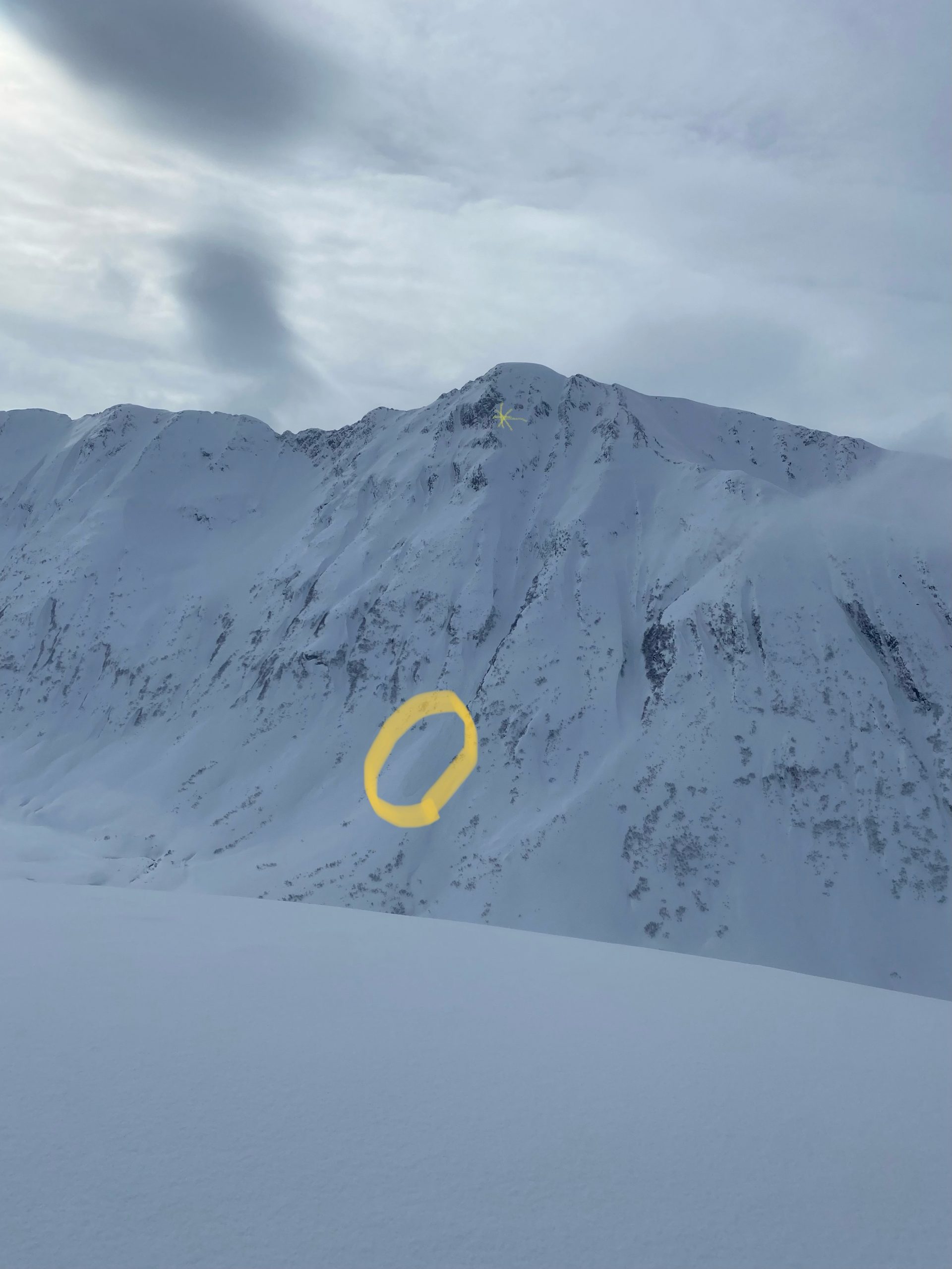
Looking down at the debris of a hard slab avalanche that failed on a layer of surface hoar buried about 18″ deep. Photo submitted anonymously. 03.12.2022

Typical setup on shaded aspects on Seattle Ridge. This snowpit was dug right next to the crown of an avalanche that released last Sunday, and did not show any propagating results in stability tests yesterday. 03.12.2022

Weather
Sun, March 13th, 2022

Yesterday: Skies were partly cloudy, with some areas seeing quite a bit of sunshine. Winds were light out of the east at around 5 mph with gusts of 10-15 mph. Light snowfall in the morning did not amount to any measurable precipitation. High temperatures reached the upper 20’s to upper 30’s F, and overnight lows were in the upper teens to upper 20’s F.

Today: We are looking at another pleasant day, with light northeasterly winds at 5-10 mph and gusts of 10-15 mph. Skies will once again be partly cloudy, and high temperatures will reach the mid 20’s to low 30’s F. Most of the advisory area will be dry, but the Portage and Placer zones may see a trace to 3″ of snow during the day. Skies should clear overnight, allowing temperatures to drop down to the mid to upper teens F.

Tomorrow: It’s gonna be a bright sunshiny day tomorrow, as Jimmy Cliff would say. Clouds should clear out tonight, with mostly sunny skies during the day tomorrow. Winds will be light out of the west at 5-10 mph and no precipitation is expected. It is looking like the weather will remain quiet through Tuesday before things start picking up again with heavy snow possible Wednesday-Friday. Stay tuned for more.

PRECIPITATION 24-hour data (6am – 6am)

Temp Avg (F) Snow (in) Water (in) Snow Depth (in)
Center Ridge (1880′) 32 0 0 91
Summit Lake (1400′) 29 0 0 40
Alyeska Mid (1700′) 33* 0* 0* N/A

*Last reporting at 1:00 a.m.

RIDGETOP 24-hour data (6am – 6am)

Temp Avg (F) Wind Dir Wind Avg (mph) Wind Gust (mph)
Sunburst (3812′) 22 E 8 19
Seattle Ridge (2400′) 26 ESE 7 12
Observations
Recent Observations for Turnagain Pass
Date Region Location
04/23/24 Turnagain Observation: Turnagain Sunny Side
04/21/24 Turnagain Observation: Bertha Creek
04/20/24 Turnagain Avalanche: Spokane Creek
04/16/24 Turnagain Observation: Cornbiscuit
04/15/24 Turnagain Observation: Taylor Pass
04/15/24 Turnagain Observation: Seward Highway – Tern Lake to Portage
04/14/24 Turnagain Observation: Sunburst
04/14/24 Turnagain Observation: Turnagain Pass Snomo
04/13/24 Turnagain Observation: Spokane Creek
04/11/24 Turnagain Observation: Tincan
Riding Areas

The riding areas page has moved. Please click here & update your bookmarks.


Subscribe to Turnagain Pass
Avalanche Forecast by Email

This is a general backcountry avalanche advisory issued for Turnagain Arm with Turnagain Pass as the core advisory area. This advisory does not apply to highways, railroads or operating ski areas.