Turnagain Pass Avalanche Forecast
|
![]() ![]() |
The avalanche danger is MODERATE above 1000′. Lingering wind slabs 1-2′ deep are possible for human triggering today and will most likely be found at upper elevations along ridgelines and cross loaded gullies. Larger avalanches releasing on persistent weak layers are also possible, so careful evaluation of the snowpack is recommended before entering avalanche terrain. Wet loose avalanches on southerly aspects are very likely if the sun shines today. The avalanche danger is LOW below 1000′.
Signal Word | Size (D scale) | Simple Descriptor |
Small | 1 | Unlikely to bury a person |
Large | 2 | Can bury a person |
Very Large | 3 | Can destroy a house |
Historic | 4 & 5 | Can destroy part or all of a village |
With broken cloud cover and warm temperatures yesterday it really felt like a spring day, and the sun played the biggest role in shaping the snow surface conditions. Steeper southerly aspects that had solar input were covered in roller balls and wet loose avalanches that were releasing naturally and from skier traffic. On northerly aspects the snow surface stayed dry at upper elevations and we found wind slabs that were reactive in hand pits and felt hollow along upper ridgelines. The potential for human triggered wind slabs still exists at upper elevations but they will be more stubborn to trigger after having some time to bond with the underlying snow surface, and the depth of the wind slabs depends on how much new snow fell this week. In portions of the forecast area that received more snow this week, like Girdwood, Portage, and Placer, wind slabs up to 2′ deep are possible, but in areas that saw limited new snow those wind slabs will be shallower.
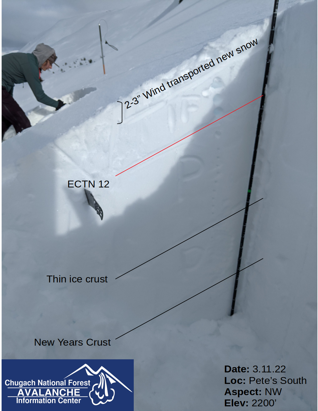
Cloudy conditions obscured the alpine terrain during the later part of this week so we have limited information from upper elevations. We recommend approaching avalanche terrain cautiously and testing stability on lower angle and less exposed slopes before entering steeper terrain. There are still persistent weak layers in the upper snowpack that appear to be more prevalent in certain portions of the forecast area, such as the northern end of Turnagain Pass and Seattle Ridge (see problem 2 for more details).
Wet Loose Avalanches: As mentioned above, all aspects receiving solar input yesterday were producing a lot of wet loose avalanches both naturally and from skier travel. In steeper terrain wet loose avalanches can build a lot of momentum and easily knock a skier or rider off balance, so be aware of moving snow around you and the potential for natural wet loose avalanches off ridgelines.
Cornices: Strong solar warming on the face of cornices can weaken them and cause natural or human triggered cornice fall. We have a lot of large cornices across the forecast area which could start to shed some of their weight if the sun is out today.
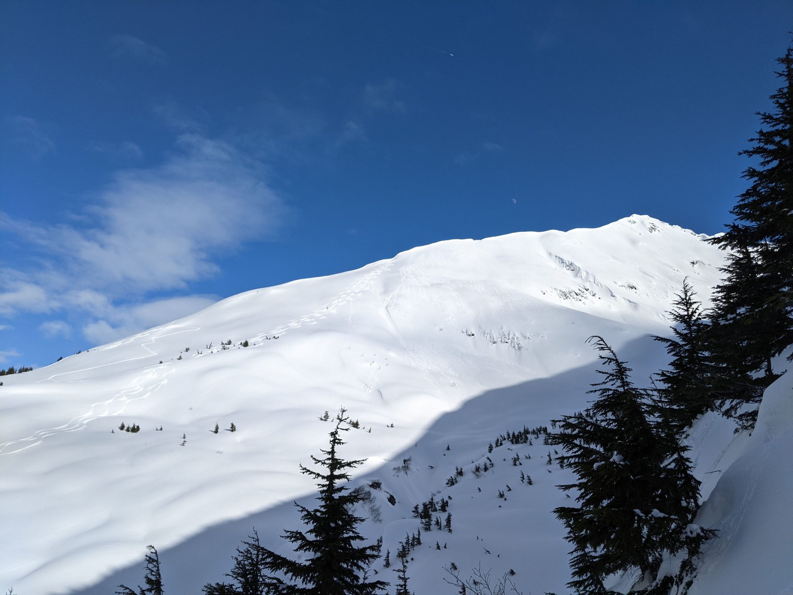
Natural wet loose avalanches on the southern aspects of Pete’s N yesterday. We also released a lot of wet loose snow skiing on W aspects at lower elevations on Pete’s S. Photo 3.11.22
Signal Word | Size (D scale) | Simple Descriptor |
Small | 1 | Unlikely to bury a person |
Large | 2 | Can bury a person |
Very Large | 3 | Can destroy a house |
Historic | 4 & 5 | Can destroy part or all of a village |
We have been tracking a layer of surface hoar that was buried on 3.2 and was likely responsible for natural and human triggered avalanches in Turnagain Pass and Seattle Ridge. Since this layer of buried surface hoar is sitting on top of a firm surface it has the potential to linger in the snowpack and continue to produce avalanches. You can use hand pits or snow pits to check whether this layer exists where you are travelling by looking at and feeling the layers in the upper 1-3′ of the snowpack. If the buried surface hoar grains are small it can be hard to see them with the naked eye and using instability tests like hand shears, compression tests, or extended column tests can help reveal if this layer is a problem.
In addition to the 3.2 buried surface hoar we have found layers of near surface facets in the snowpack, especially on solar aspects (east, south, west). This is another persistent weak layer that can produce wider propagating avalanches and can be tested using instability tests like an extended column test to see if it is reactive in the area you are travelling. If you are not confident in your ability to evaluate these layers we recommend conservative terrain choices until we have more information about the distribution and reactivity of these persistent weak layers.
Extended column test failure without propagation on a layer that looked like near surface facets about 10″ down from the surface. Photo 3.11.22
Yesterday: Broken sky cover with waves of low clouds moving through that would obscure upper ridgelines. No new snow in Turnagain or Girdwood, but Portage received 0.25″ of water at sea level which could mean 2-4″ of snow at upper elevations. Winds were calm to light and temperatures were in the mid to upper 30s at lower elevations and 20s at upper elevations.
Today: Chance of snow flurries with no significant accumulation expected in Turnagain or Girdwood and the potential for 1-3″ in Portage and Placer. Winds in the 5-15 mph range with gusts of 15-25 mph. Temperatures should stay relatively consistent, in the 30s at lower elevations and 20s at upper elevations.
Tomorrow: Similar to Saturday with the potential for Portage and Placer to receive up to 1-4″ of snow during the day. The rest of the forecast area looks like they won’t receive any significant snowfall. Winds will remain calm to light. Monday and Tuesday look like quiet days with less chance of cloud cover before another low pressure system enters the area Tuesday afternoon.
PRECIPITATION 24-hour data (6am – 6am)
Temp Avg (F) | Snow (in) | Water (in) | Snow Depth (in) | |
---|---|---|---|---|
Center Ridge (1880′) | 35 | 0 | 0 | 92 |
Summit Lake (1400′) | 33 | 0 | 0 | 40 |
Alyeska Mid (1700′) | 34 | 0 | 0 | NA |
RIDGETOP 24-hour data (6am – 6am)
Temp Avg (F) | Wind Dir | Wind Avg (mph) | Wind Gust (mph) | |
---|---|---|---|---|
Sunburst (3812′) | 23 | E | 8 | 20 |
Seattle Ridge (2400′) | 28 | ESE | 10 | 16 |
Date | Region | Location | Observer |
---|---|---|---|
05/22/23 | Turnagain | Avalanche: Tincan | Nick D'Alessio |
05/12/23 | Turnagain | Avalanche: Tincan, Sunburst, Magnum, Cornbiscuit | Heather Thamm |
05/07/23 | Turnagain | Observation: Tincan – Bear Tracks | CNFAIC Staff |
05/05/23 | Turnagain | Observation: Seattle Ridge | AS/ WW Forecaster |
05/02/23 | Turnagain | Observation: Cornbiscuit | Schauer/ Sturgess Forecaster |
05/02/23 | Turnagain | Observation: Seward Hwy Turnagain Pass | Joel Curtis |
04/30/23 | Turnagain | Observation: Magnum | Ayla, Kit Crosby, Barton |
04/29/23 | Turnagain | Observation: Tincan | John Sykes |
04/28/23 | Turnagain | Avalanche: Taylor Pass/Pastoral | Schauer/ Creighton Forecaster |
04/28/23 | Turnagain | Avalanche: Tincan | Andy Moderow |
Status of riding areas across the Chugach NF is managed by the Glacier and Seward Ranger Districts, not avalanche center staff. Riding area information is posted as a public service to our users and updated based on snow depth and snow density to prevent resource damage at trailhead locations. Riding area questions contact: mailroom_r10_chugach@fs.fed.us
Area | Status | Weather & Riding Conditions |
---|---|---|
Glacier District |
Subscribe to Turnagain Pass
Avalanche Forecast by Email
This is a general backcountry avalanche advisory issued for Turnagain Arm with Turnagain Pass as the core advisory area. This advisory does not apply to highways, railroads or operating ski areas.