Turnagain Pass RSS

Archives
ARCHIVED - Forecasts expire after 24 hours.
Issued
Mon, March 14th, 2022 - 7:00AM
Expires
Tue, March 15th, 2022 - 7:00AM
Forecaster
John Sykes
Avalanche risk The Bottom Line

The avalanche danger is MODERATE above 1000′. A period of elevated winds yesterday created fresh wind slabs at upper elevations that could be up to 1′ deep and are possible for a person to trigger today. This fresh wind loading occurred on top of buried persistent weak layers that can be difficult to identify in the snowpack and cause large avalanches on surprisingly low angle terrain. Conservative decision-making and terrain selection is recommended while these weak layers linger in the upper snowpack. Wet loose avalanches are very likely on steeper aspects exposed to the sun today. Below 1000′ the avalanche danger is LOW.

Special Announcements
  • Come join us for the Turnagain Pass Avalanche Awareness Day on Saturday, March 19th in the Seattle Ridge parking lot. Chat with CNFAIC forecasters, try out some avalanche rescue gear, and demo a snowmachine or two from local businesses such as AMDS and Anchorage Yamaha and Polaris.
Mon, March 14th, 2022
Alpine
Above 2,500'
2 - Moderate
Avalanche risk
Treeline
1,000'-2,500'
2 - Moderate
Avalanche risk
Below Treeline
Below 1,000'
1 - Low
Avalanche risk
0 - No Rating
1 - Low
2 - Moderate
3 - Considerable
4 - High
5 - Extreme
Avalanche risk Avalanche risk Avalanche risk Avalanche risk Avalanche risk
Travel Advice Generally safe avalanche conditions. Watch for unstable snow on isolated terrain features. Heightened avalanche conditions on specific terrain features. Evaluate snow and terrain carefully; identify features of concern. Dangerous avalanche conditions. Careful snowpack evaluation, cautious route-finding, and conservative decision-making essential. Very dangerous avalanche conditions. Travel in avalanche terrain not recommended. Extraordinarily dangerous avalanche conditions. Avoid all avalanche terrain.
Likelihood of Avalanches Natural and human-triggered avalanches unlikely. Natural avalanches unlikely; human-triggered avalanches possible. Natural avalanches possible; human-triggered avalanches likely. Natural avalanches likely; human-triggered avalanches very likely. Natural and human-triggered avalanches certain.
Avalanche Size and Distribution Small avalanches in isolated areas or extreme terrain. Small avalanches in specific areas; or large avalanches in isolated areas. Small avalanches in many areas; or large avalanches in specific areas; or very large avalanches in isolated areas. Large avalanches in many areas; or very large avalanches in specific areas. Very large avalanches in many areas.
Avalanche Problem 1
  • Wind Slabs
    Wind Slabs
  • Certain
    Very Likely
    Likely
    Possible
    Unlikely
    Likelihood
  • Historic (D4-5)
    Very Large (D3)
    Large (D2)
    Small (D1)
    Size
Wind Slabs
Wind Slab avalanches are the release of a cohesive layer of snow (a slab) formed by the wind. Wind typically transports snow from the upwind sides of terrain features and deposits snow on the downwind side. Wind slabs are often smooth and rounded and sometimes sound hollow, and can range from soft to hard. Wind slabs that form over a persistent weak layer (surface hoar, depth hoar, or near-surface facets) may be termed Persistent Slabs or may develop into Persistent Slabs.

Likelihood of Avalanches
Terms such as "unlikely", "likely", and "certain" are used to define the scale, with the chance of triggering or observing avalanches increasing as we move up the scale. For our purposes, "Unlikely" means that few avalanches could be triggered in avalanche terrain and natural avalanches are not expected. "Certain" means that humans will be able to trigger avalanches on many slopes, and natural avalanches are expected.

Size of Avalanches
Avalanche size is defined by the largest potential avalanche, or expected range of sizes related to the problem in question. Assigned size is a qualitative estimate based on the destructive classification system and requires specialists to estimate the harm avalanches may cause to hypothetical objects located in the avalanche track (AAA 2016, CAA 2014). Under this schema, "Small" avalanches are not large enough to bury humans and are relatively harmless unless they carry people over cliffs or through trees or rocks. Moving up the scale, avalanches become "Large" enough to bury, injure, or kill people. "Very Large" avalanches may bury or destroy vehicles or houses, and "Historic" avalanches are massive events capable of altering the landscape.

Signal Word Size (D scale) Simple Descriptor
Small 1 Unlikely to bury a person
Large 2 Can bury a person
Very Large 3 Can destroy a house
Historic 4 & 5 Can destroy part or all of a village
More info at Avalanche.org

A surprise pulse of moderate winds came through the area yesterday from around 10 am to 11 pm which created fresh wind slabs at upper elevations. Unfortunately, the Sunburst weather station stopped reporting just as these winds kicked up so we are in the dark about the exact speeds and duration in Turnagain Pass. Weather stations near Grandview and Alyeska reported similar increases in wind speeds yesterday with averages of 10-20 mph and gusts of 20-30 mph for about 12 hours. Clouds lingering in the area also produced 1-3″ of new snow in Turnagain Pass and Portage/Placer area, with no measurable new snow in the Girdwood area yesterday.

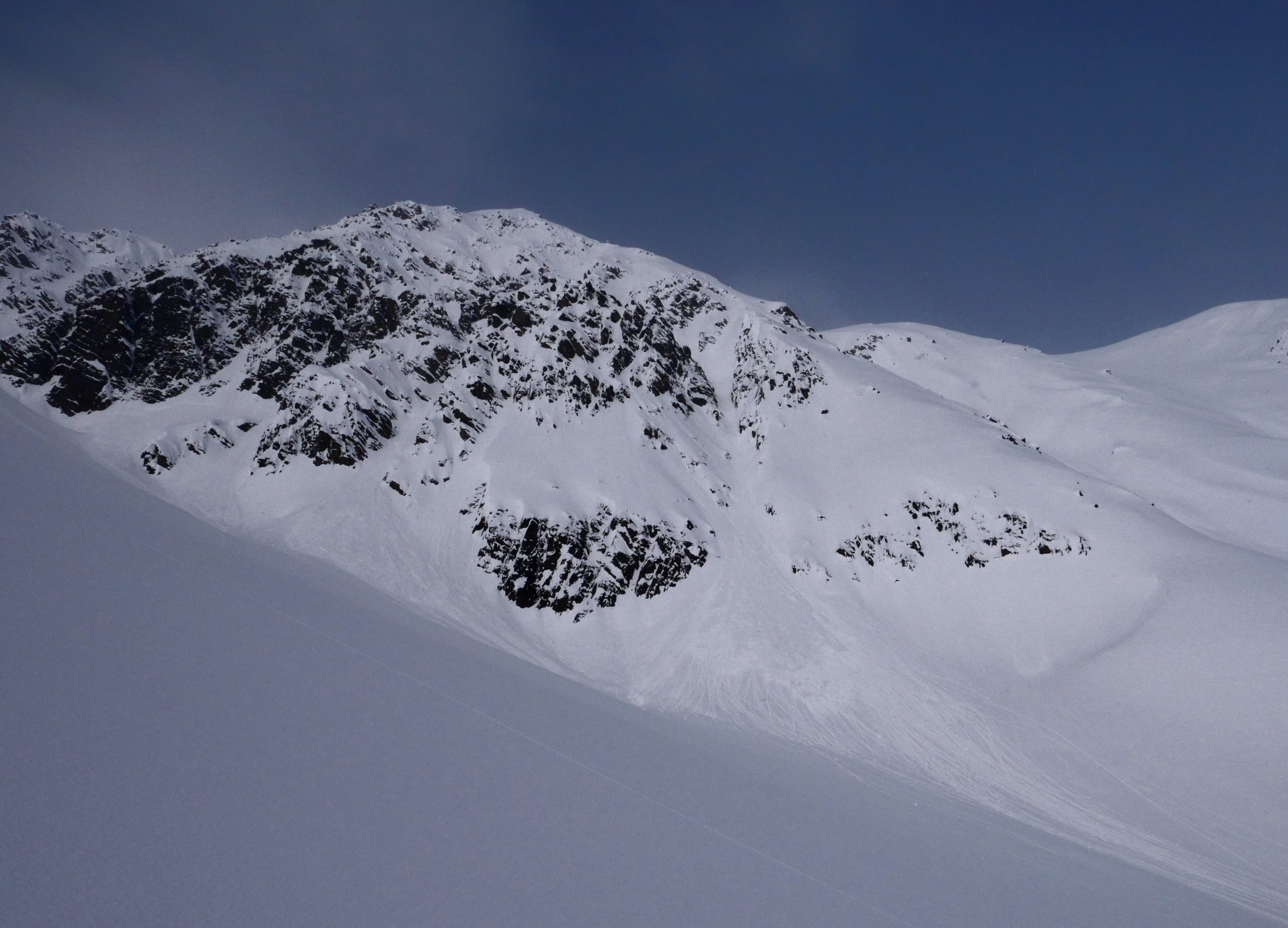
The primary avalanche problem today will be wind slabs created during the period of elevated winds yesterday which will be possible for a person to trigger today. These could be up to 1′ deep depending on how much soft snow was available at the surface for the winds to transport. The most likely area for deeper wind slabs are upper elevations on northerly terrain where dry snow still remained on the surface yesterday. These wind slabs formed on top of buried persistent weak layers and the added load could make deeper weak layers more reactive (see problem 2 for more details).

Wet Loose Avalanches: The forecast is for mostly sunny skies today, which should give the sun enough time to warm up the snow surface and create prime conditions for roller balls and wet loose avalanches. These are typically not large enough to bury a person but they can be more forceful than expected, especially if they catch you off guard in steeper terrain.

Cornices: Solar warming on cornices can cause natural cornice fall or weaken them to the point where it is easier for a person to initiate a cornice fall. We have some chunky cornices across the forecast area right now, so be aware of travelling underneath them if they are heating up in the sun and give a wide berth when travelling along ridgelines.

Glide: The warm temperatures the past few weeks have helped awaken glide cracks, with new ones opening up along Seattle Ridge near the uptrack, Tincan ridgeline, and Eddies. As always try to minimize your time spent underneath these because they can produce very large avalanches and are completely unpredictable.

Avalanche Problem 2
  • Persistent Slabs
    Persistent Slabs
  • Certain
    Very Likely
    Likely
    Possible
    Unlikely
    Likelihood
  • Historic (D4-5)
    Very Large (D3)
    Large (D2)
    Small (D1)
    Size
Persistent Slabs
Persistent Slab avalanches are the release of a cohesive layer of snow (a slab) in the middle to upper snowpack, when the bond to an underlying persistent weak layer breaks. Persistent layers include: surface hoar, depth hoar, near-surface facets, or faceted snow. Persistent weak layers can continue to produce avalanches for days, weeks or even months, making them especially dangerous and tricky. As additional snow and wind events build a thicker slab on top of the persistent weak layer, this avalanche problem may develop into a Deep Persistent Slab.

Likelihood of Avalanches
Terms such as "unlikely", "likely", and "certain" are used to define the scale, with the chance of triggering or observing avalanches increasing as we move up the scale. For our purposes, "Unlikely" means that few avalanches could be triggered in avalanche terrain and natural avalanches are not expected. "Certain" means that humans will be able to trigger avalanches on many slopes, and natural avalanches are expected.

Size of Avalanches
Avalanche size is defined by the largest potential avalanche, or expected range of sizes related to the problem in question. Assigned size is a qualitative estimate based on the destructive classification system and requires specialists to estimate the harm avalanches may cause to hypothetical objects located in the avalanche track (AAA 2016, CAA 2014). Under this schema, "Small" avalanches are not large enough to bury humans and are relatively harmless unless they carry people over cliffs or through trees or rocks. Moving up the scale, avalanches become "Large" enough to bury, injure, or kill people. "Very Large" avalanches may bury or destroy vehicles or houses, and "Historic" avalanches are massive events capable of altering the landscape.

Signal Word Size (D scale) Simple Descriptor
Small 1 Unlikely to bury a person
Large 2 Can bury a person
Very Large 3 Can destroy a house
Historic 4 & 5 Can destroy part or all of a village
More info at Avalanche.org

While the fresh wind slabs are the most likely avalanche for a person to trigger, the presence of buried surface hoar and near surface facets in the upper 2′ of the snowpack should be the driving factor in decision-making practices today. Over the weekend there were two reported near misses from Turnagain Pass where the 4th skier on a slope triggered an avalanche on a persistent weak layer. In one of those incidents we know that a very experienced group actively searched for the buried surface hoar in the area they were travelling and did not find it before triggering the avalanche on the descent. This should be a real wake up call for all of us that buried surface hoar can be difficult to find even by an experienced person and has the potential to produce large avalanches on surprisingly low angle terrain.

Both of the recent near misses occurred in high elevation terrain on northern aspects in Turnagain Pass. That is a good indicator of the most likely place to trigger an avalanche on these persistent weak layers, but it does not mean that it is impossible to find a reactive pocket of these weak layers in another location. We recommend conservative terrain selection and careful snowpack evaluation if you decide to enter avalanche terrain today. To minimize the exposure of your group, remember to only expose 1 group member at a time in avalanche terrain, always spot your partners, and group up outside the runout zone on the descent. To avoid this problem all together stick to lower angle terrain and lower elevation slopes.

Clouds and light snow lingering over the area yesterday, while surprise winds created fresh wind slabs at upper elevations. Photo 3.13.22

Wet loose avalanches on steep southern terrain are expected as the sun warms up the snow surface today. Photo 3.13.22

Weather
Mon, March 14th, 2022

Yesterday: Cooler temperatures yesterday, with averages in the upper 20s at lower elevations and upper teens to low 20s at upper elevations. Winds picked up at upper elevations around 10am with averages in from 10-20 mph and gusts of 20-30 mph. The elevated winds lasted until around 11pm when they backed off with averages in the single digits and gusts of 10-15 mph overnight. Unfortunately, Sunburst weather station stopped reporting data at 1pm yesterday, so these wind speeds are estimated from stations near Grandview and Alyeska. Light snowfall starting in the afternoon resulted in 1″ of water reported at Center Ridge, with no snowfall reported at Alyeska.

Today: Temperatures will remain cooler today with lows in the mid 20s at lower elevations and upper teens at upper elevations. Winds are forecast to remain calm to light today with averages below 10 mph. No snow expected. The lingering clouds in the area yesterday are expected to move south making way for clearer skies.

Tomorrow: Tuesday is forecast to be largely similar to today, with light winds and mostly clear skies. Another low pressure system will enter the area overnight on Tuesday and into Wednesday bringing increased winds and snow. Stay tuned for updates as the system approaches.

PRECIPITATION 24-hour data (6am – 6am)

Temp Avg (F) Snow (in) Water (in) Snow Depth (in)
Center Ridge (1880′) 30 1 0.1 92
Summit Lake (1400′) 27 0 0.1 40
Alyeska Mid (1700′) 26 0 0 NA

RIDGETOP 24-hour data (6am – 6am)

Temp Avg (F) Wind Dir Wind Avg (mph) Wind Gust (mph)
Sunburst (3812′) *19 *NE *14 *30
Seattle Ridge (2400′) 23 variable 4 12

*Sunburst weather station stopped reporting data at 1pm yesterday 3.13.22

Observations
Recent Observations for Turnagain Pass
Date Region Location
04/16/24 Turnagain Observation: Cornbiscuit
04/15/24 Turnagain Observation: Taylor Pass
04/15/24 Turnagain Observation: Seward Highway – Tern Lake to Portage
04/14/24 Turnagain Observation: Sunburst
04/14/24 Turnagain Observation: Turnagain Pass Snomo
04/13/24 Turnagain Observation: Spokane Creek
04/11/24 Turnagain Observation: Tincan
04/10/24 Turnagain Avalanche: Seattle Ridge
04/10/24 Turnagain Observation: Cornbiscuit South Face
04/10/24 Turnagain Avalanche: Tincan
Riding Areas

The riding areas page has moved. Please click here & update your bookmarks.


Subscribe to Turnagain Pass
Avalanche Forecast by Email

This is a general backcountry avalanche advisory issued for Turnagain Arm with Turnagain Pass as the core advisory area. This advisory does not apply to highways, railroads or operating ski areas.