Turnagain Pass Avalanche Forecast
|
![]() ![]() |
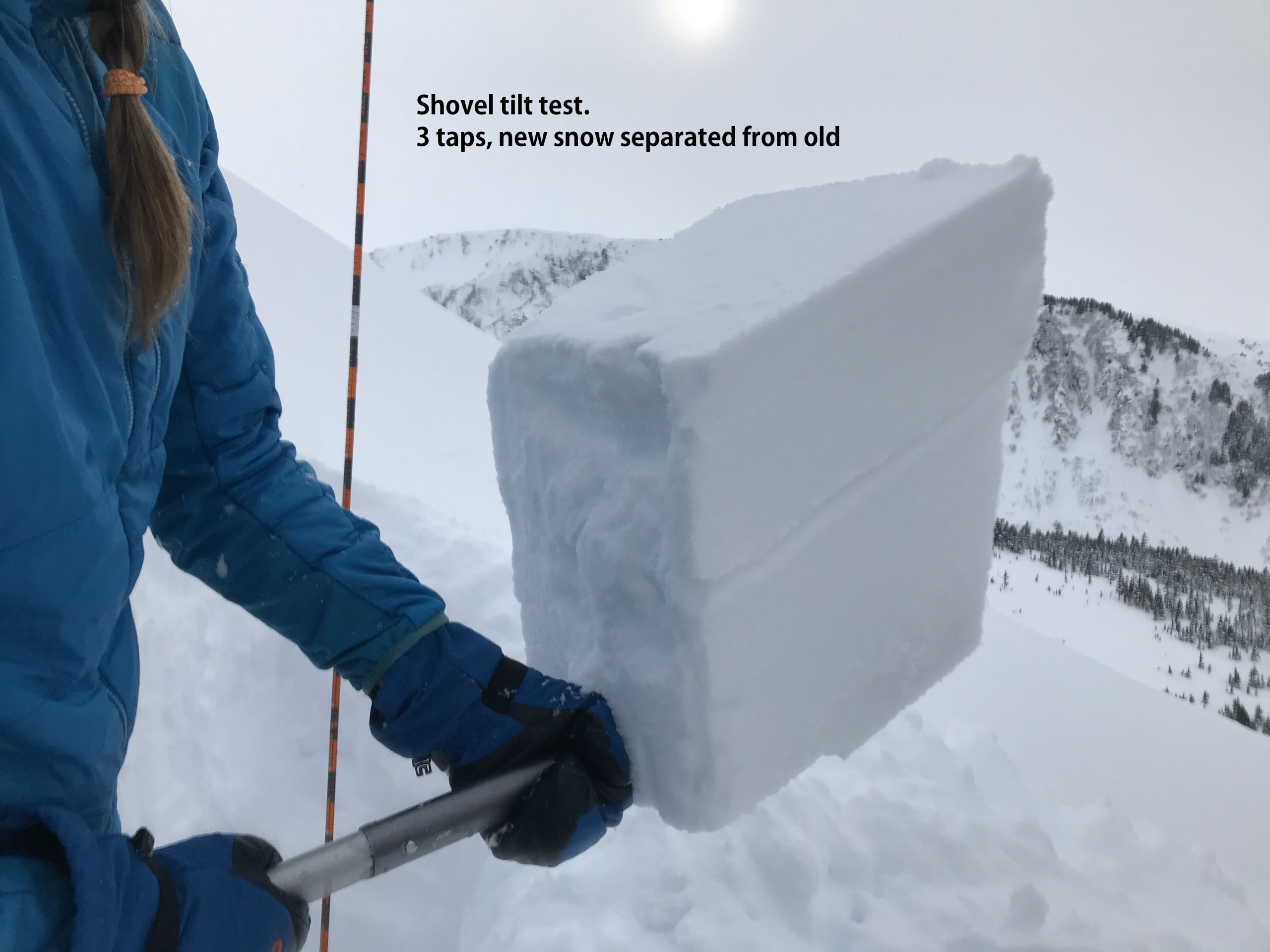
The avalanche danger is MODERATE today at all elevations. Triggering a wind slab around 1-2′ deep is possible in steep wind loaded terrain. Additionally, there is still a chance of triggering a deep persistent slab. Avoid travel on or underneath cornices and watch your sluff on steep protected slopes.
SUMMIT LAKE: South of Turnagain Pass the overall snowpack is shallower, with poor snowpack structure and was more affected by the outflow event last week. Triggering a large avalanche that breaks on weak faceted snow is possible. Extra caution is advised. Choose terrain carefully.
Signal Word | Size (D scale) | Simple Descriptor |
Small | 1 | Unlikely to bury a person |
Large | 2 | Can bury a person |
Very Large | 3 | Can destroy a house |
Historic | 4 & 5 | Can destroy part or all of a village |
Winds today are forecast to be light and westerly and new wind slab formation is not likely during the day. The concern is triggering a wind slab that formed over the past couple days of easterly winds or an older one from the westerly outflow event last week. Wind slabs tend to heal up fairly soon after a wind loading event, especially with warmer temperatures. The question is whether this healing has happened or will these wind slabs actually stay reactive due to a buried layer of surface hoar and transition into a persistent slab issue. The wind slabs could be 1-2′ thick and will most likely be found in Alpine terrain on loaded slopes just off of the ridgelines and in gully features. As you travel in the mountains watch for signs of instability like cracking or collapsing. Steep terrain with hard wind affected snow over soft snow is the most suspect. Avoid terrain features with hard snow that look fat and loaded.
The question of the day is whether or not this weak interface on the buried surface hoar is an issue that heals up or lingers? 3.7. 20. Wolverine. Photo: Peter Wadsworth
Cornices: Avoid travel on or underneath cornices.
Loose snow avalanches: In areas that were protected from the wind, sluffs are possible in steep terrain.
Sun effect: If the sun pokes out today look for signs of sun effect on steep solar aspects: moist surface snow, small roller balls or loose snow avalanches in protected spots, especially below rocky areas.
Signal Word | Size (D scale) | Simple Descriptor |
Small | 1 | Unlikely to bury a person |
Large | 2 | Can bury a person |
Very Large | 3 | Can destroy a house |
Historic | 4 & 5 | Can destroy part or all of a village |
There is nagging worry that someone will hit the wrong spot and trigger a very large avalanche on that fails on the weak faceted snow from January. This is still lurking 3 to 6 feet deep in the snowpack. The wind slab triggered in Lynx Creek last Thursday was a larger avalanche because it ‘stepped down’ into these old weak layers. As time passes the likelihood of triggering a deep slab is decreasing, i.e. is unlikely. However, the snowpack structure for this avalanche problem still exists and an outlier avalanche could be a nasty surprise. Areas that have a shallower snowpack are more concerning, places like Lynx Creek or Twin Peaks and south through Summit Lake. As always, use good travel protocol and as you choose your route consider the consequences if a deep slab was triggered.
Yesterday: Skies were cloudy and there were light snow showers throughout the day with around 1-6″ accumulating, favoring upper elevation Girdwood. Temperatures were in the high teens to low 20°Fs in the Alpine and the high 20°Fs to high 30°Fs at lower elevations. Winds were easterly 5-15 mph with gusts into the 30s. Overnight snow showers stopped, temperatures dipped slightly and winds became light.
Today: Skies will be mostly cloudy with a chance of snow showers and/or a pocket or two of clearing in the afternoon. Temperatures will in the high teens to high 20°Fs depending on elevation. Winds will be light and westerly during the day. As skies clear overnight and cooler air moves in, northwest outflow winds will start to pick up. Overnight lows will be in the single digits.
Tomorrow: Mostly sunny skies and temperatures in the teens. Winds will be northwesterly 15-25 with gusts into the 30s and 40s. Winds look to peak during the day and then ease off overnight into Wednesday. Skies will be clear overnight with temperatures in the low single digits. The forecast is for clear and sunny with an overall warming trend through the spring break week! Time to bust out the sunglasses and sunscreen!
PRECIPITATION 24-hour data (6am – 6am)
Temp Avg (F) | Snow (in) | Water (in) | Snow Depth (in) | |
---|---|---|---|---|
Center Ridge (1880′) | 27 | 1 | 0.1 | 70 |
Summit Lake (1400′) | 25 | 1 | 0.1 | 31 |
Alyeska Mid (1700′) | 27 | 3 | 0.26 | 80 |
RIDGETOP 24-hour data (6am – 6am)
Temp Avg (F) | Wind Dir | Wind Avg (mph) | Wind Gust (mph) | |
---|---|---|---|---|
Sunburst (3812′) | 17 | NE | 10 | 33 |
Seattle Ridge (2400′) | 22 | E | 7 | 19 |
Date | Region | Location | Observer |
---|---|---|---|
05/22/23 | Turnagain | Avalanche: Tincan | Nick D'Alessio |
05/12/23 | Turnagain | Avalanche: Tincan, Sunburst, Magnum, Cornbiscuit | Heather Thamm |
05/07/23 | Turnagain | Observation: Tincan – Bear Tracks | CNFAIC Staff |
05/05/23 | Turnagain | Observation: Seattle Ridge | AS/ WW Forecaster |
05/02/23 | Turnagain | Observation: Cornbiscuit | Schauer/ Sturgess Forecaster |
05/02/23 | Turnagain | Observation: Seward Hwy Turnagain Pass | Joel Curtis |
04/30/23 | Turnagain | Observation: Magnum | Ayla, Kit Crosby, Barton |
04/29/23 | Turnagain | Observation: Tincan | John Sykes |
04/28/23 | Turnagain | Avalanche: Taylor Pass/Pastoral | Schauer/ Creighton Forecaster |
04/28/23 | Turnagain | Avalanche: Tincan | Andy Moderow |
Status of riding areas across the Chugach NF is managed by the Glacier and Seward Ranger Districts, not avalanche center staff. Riding area information is posted as a public service to our users and updated based on snow depth and snow density to prevent resource damage at trailhead locations. Riding area questions contact: mailroom_r10_chugach@fs.fed.us
Area | Status | Weather & Riding Conditions |
---|---|---|
Glacier District |
Subscribe to Turnagain Pass
Avalanche Forecast by Email
This is a general backcountry avalanche advisory issued for Turnagain Arm with Turnagain Pass as the core advisory area. This advisory does not apply to highways, railroads or operating ski areas.