Turnagain Pass RSS

Archives
ARCHIVED - Forecasts expire after 24 hours.
Issued
Sun, February 20th, 2022 - 7:00AM
Expires
Mon, February 21st, 2022 - 7:00AM
Forecaster
Andrew Schauer
Avalanche risk The Bottom Line

The avalanche danger is MODERATE today. It is possible a person could trigger an avalanche 1-2′ deep on lingering slabs that formed overnight Thursday into early Friday morning on top of weak surfaces. In some of the areas along the far northern and southern edges of our forecast zone, it is also possible a person could trigger a deeper avalanche on weak layers surrounding older crusts buried 2-4′ deep. A higher uncertainty with the recently buried weak layer will require careful terrain selection today, leaving the bigger objectives for another day.

Special Announcements

We’ve posted a deeper look into two near-misses from this season in our latest News Post. There are some valuable lessons to be learned from both incidents, and it is absolutely worth the time to read through the details.

Sun, February 20th, 2022
Alpine
Above 2,500'
2 - Moderate
Avalanche risk
Treeline
1,000'-2,500'
2 - Moderate
Avalanche risk
Below Treeline
Below 1,000'
2 - Moderate
Avalanche risk
0 - No Rating
1 - Low
2 - Moderate
3 - Considerable
4 - High
5 - Extreme
Avalanche risk Avalanche risk Avalanche risk Avalanche risk Avalanche risk
Travel Advice Generally safe avalanche conditions. Watch for unstable snow on isolated terrain features. Heightened avalanche conditions on specific terrain features. Evaluate snow and terrain carefully; identify features of concern. Dangerous avalanche conditions. Careful snowpack evaluation, cautious route-finding, and conservative decision-making essential. Very dangerous avalanche conditions. Travel in avalanche terrain not recommended. Extraordinarily dangerous avalanche conditions. Avoid all avalanche terrain.
Likelihood of Avalanches Natural and human-triggered avalanches unlikely. Natural avalanches unlikely; human-triggered avalanches possible. Natural avalanches possible; human-triggered avalanches likely. Natural avalanches likely; human-triggered avalanches very likely. Natural and human-triggered avalanches certain.
Avalanche Size and Distribution Small avalanches in isolated areas or extreme terrain. Small avalanches in specific areas; or large avalanches in isolated areas. Small avalanches in many areas; or large avalanches in specific areas; or very large avalanches in isolated areas. Large avalanches in many areas; or very large avalanches in specific areas. Very large avalanches in many areas.
Recent Avalanches

Yesterday’s clear skies gave plenty of opportunity to assess the extent of Friday’s natural cycle. The exact timing of some of the avalanches was uncertain, but we know there were some natural slab avalanches later in the day Friday that were triggered by loose avalanches when the sun came out in the afternoon. Almost all of the avalanches around Turnagain Pass were around 1-2′ deep, and are suspected to have failed on an interface from the beginning of last week’s parade of storms. Here are a few photos from the cycle.

Wide-propagation in Lynx Creek, as seen from the Center Ridge parking lot. Photo: Andy Moderow. 02.19.2020

Wide crown in the bowl just east of Pastoral. Photo: Pyper Dixon. 02.19.2020

Smaller loose avalanche in motion, overrunning the crown of another recent avalanche. 02.19.2022. Photo: Andy Moderow.

Avalanche Problem 1
  • Persistent Slabs
    Persistent Slabs
  • Certain
    Very Likely
    Likely
    Possible
    Unlikely
    Likelihood
  • Historic (D4-5)
    Very Large (D3)
    Large (D2)
    Small (D1)
    Size
Persistent Slabs
Persistent Slab avalanches are the release of a cohesive layer of snow (a slab) in the middle to upper snowpack, when the bond to an underlying persistent weak layer breaks. Persistent layers include: surface hoar, depth hoar, near-surface facets, or faceted snow. Persistent weak layers can continue to produce avalanches for days, weeks or even months, making them especially dangerous and tricky. As additional snow and wind events build a thicker slab on top of the persistent weak layer, this avalanche problem may develop into a Deep Persistent Slab.

Likelihood of Avalanches
Terms such as "unlikely", "likely", and "certain" are used to define the scale, with the chance of triggering or observing avalanches increasing as we move up the scale. For our purposes, "Unlikely" means that few avalanches could be triggered in avalanche terrain and natural avalanches are not expected. "Certain" means that humans will be able to trigger avalanches on many slopes, and natural avalanches are expected.

Size of Avalanches
Avalanche size is defined by the largest potential avalanche, or expected range of sizes related to the problem in question. Assigned size is a qualitative estimate based on the destructive classification system and requires specialists to estimate the harm avalanches may cause to hypothetical objects located in the avalanche track (AAA 2016, CAA 2014). Under this schema, "Small" avalanches are not large enough to bury humans and are relatively harmless unless they carry people over cliffs or through trees or rocks. Moving up the scale, avalanches become "Large" enough to bury, injure, or kill people. "Very Large" avalanches may bury or destroy vehicles or houses, and "Historic" avalanches are massive events capable of altering the landscape.

Signal Word Size (D scale) Simple Descriptor
Small 1 Unlikely to bury a person
Large 2 Can bury a person
Very Large 3 Can destroy a house
Historic 4 & 5 Can destroy part or all of a village
More info at Avalanche.org

The storm from Thursday night fell onto some suspect surfaces, which are still giving us cause for concern today. Yesterday’s bountiful sunshine allowed us to get an idea of the extent of Friday’s natural cycle, and to assess the layering in the upper snowpack that facilitated that cycle. We are still investigating the potential weak layer that was buried on Valentine’s Day. Here is what we have seen so far:

Seattle Ridge: Groups have been finding near-surface facets and buried surface hoar about 1.5′ deep, which was propagating in some snowpit tests. (more info here).

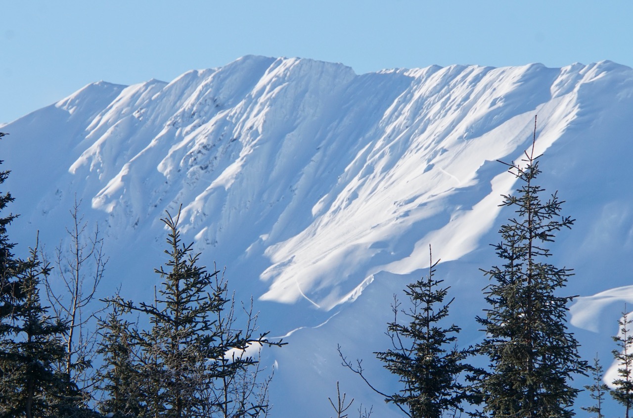
Lipps: Yesterday we found a layer of decomposing stellar dendrites buried just over a foot deep that was giving mixed results in snowpits. We suspect this layer was the culprit for at least one nearby avalanche. (Details here).

Girdwood area: One group backed off an objective after getting propagating test results on a thin rime crust buried about 1.5′ deep just north of Girdwood.

So far we are not aware of any slab avalanches that occurred yesterday, but some of these details suggest we just buried a potentially dangerous weak layer. Needless to say, there is still a high level of uncertainty with this layer. Today, this uncertainty requires a heightened level of awareness, and careful terrain selection while we see how the layer is behaving in the long run. With another quiet day of weather on tap today, it will be important to keep this potential for human-triggered avalanches in mind and avoid big or consequential terrain.

For areas with a thinner snowpack at the edges of our advisory area (Crow Pass, Lynx and Silvertip Creeks), as well as outside of our area (Summit Lake), there is an additional concern for the weak snow associated with our New Year’s and Halloween crusts. We have consistently seen poor stability test results failing on faceted snow buried 2-4′ deep in these zones. This indicates the potential for large human-triggered avalanches, and is one more reason to reign in your terrain choices in the areas with a thinner snowpack.

Loose snow avalanches: If the sun pokes out again in the afternoon we can expect to see another round of loose snow avalanches, dry and wet.

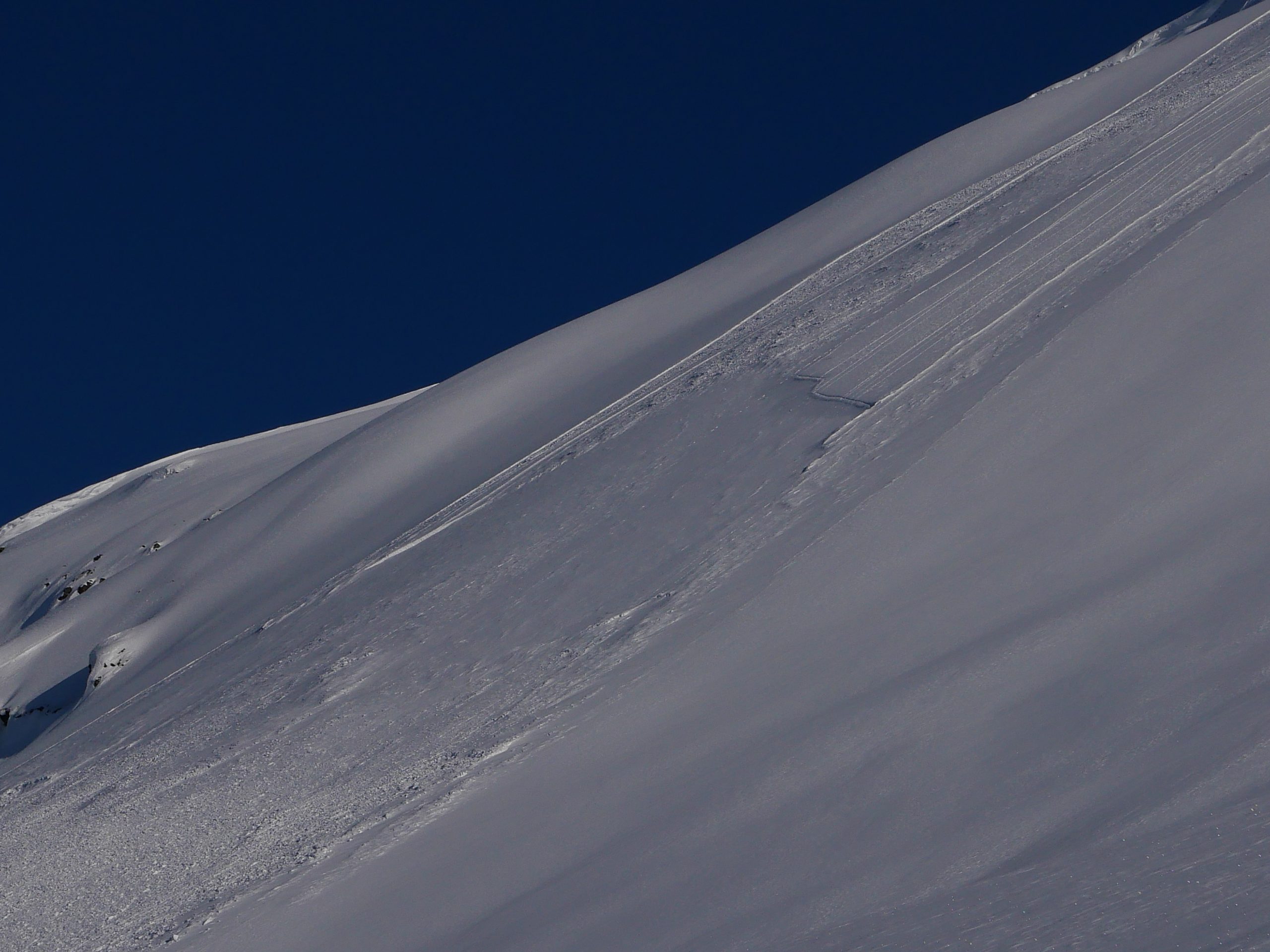
Crown of a recent natural avalanche on Lipps. The avalanche was not huge, but it was big enough to bury a person and it seemed to be a similar depth to most of the rest of the activity around Turnagain Pass. It had been partially blown in after it released. Likely depth 1-2′, triggered by loose snow avalanches releasing up slope. 02.19.2022

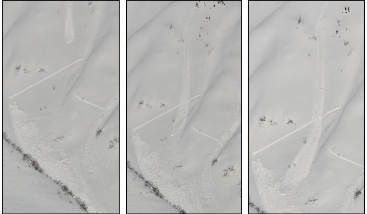
Depth to the layer of concern (decomposing stellars) on Lipps. This depth corresponds with buried facets and surface hoar on Seattle Ridge, and a rime crust north of Girdwood. 02.19.2022

Weather
Sun, February 20th, 2022

Yesterday: Yesterday was a fantastic day of clear blue skies. In fact, according to our weather charts it was the first fully clear day at Turnagain Pass since January 16th! Winds were light out of the west at around 5 mph, and temperatures were in the upper 20’s to low 30’s F at most weather stations, with some stations recording temperatures in the upper 30’s F. As of 6 a.m., low temperatures are in the upper teens to low 20’s F.

Today: Another day of quiet weather is on tap today, with mostly cloudy skies this morning and the potential for decreased cloud cover later in the day. High temperatures should be in the mid 20’s to low 30’s F, with light westerly winds around 5-10 mph and gusts of 10-20 mph. No precipitation is expected.

Tomorrow: The next round of active weather will slowly return tomorrow, with increasing clouds and winds beginning tonight, and chances for precipitation picking up late in the day tomorrow. It is looking like this system will behave similarly to last week’s storms, favoring the areas west of our advisory zone and bringing 6-8″ to Turnagain Pass and Girdwood by Tuesday morning. Sustained easterly winds will start around 15 mph tonight, increasing to 30-40 mph during the day tomorrow and gusting 30-50 mph. High temperatures will be in the mid 20’s to low 30’s F, with the snow line staying down around 100-200′ for this first round.

PRECIPITATION 24-hour data (6am – 6am)

Temp Avg (F) Snow (in) Water (in) Snow Depth (in)
Center Ridge (1880′) 29 0 0 93
Summit Lake (1400′) 22 0 0 44
Alyeska Mid (1700′) 31 0 0 98

RIDGETOP 24-hour data (6am – 6am)

Temp Avg (F) Wind Dir Wind Avg (mph) Wind Gust (mph)
Sunburst (3812′) 19 W 5 21
Seattle Ridge (2400′) 25 N 3 7
Observations
Recent Observations for Turnagain Pass
Date Region Location
04/16/24 Turnagain Observation: Cornbiscuit
04/15/24 Turnagain Observation: Taylor Pass
04/15/24 Turnagain Observation: Seward Highway – Tern Lake to Portage
04/14/24 Turnagain Observation: Sunburst
04/14/24 Turnagain Observation: Turnagain Pass Snomo
04/13/24 Turnagain Observation: Spokane Creek
04/11/24 Turnagain Observation: Tincan
04/10/24 Turnagain Avalanche: Seattle Ridge
04/10/24 Turnagain Observation: Cornbiscuit South Face
04/10/24 Turnagain Avalanche: Tincan
Riding Areas

The riding areas page has moved. Please click here & update your bookmarks.


Subscribe to Turnagain Pass
Avalanche Forecast by Email

This is a general backcountry avalanche advisory issued for Turnagain Arm with Turnagain Pass as the core advisory area. This advisory does not apply to highways, railroads or operating ski areas.