Turnagain Pass Avalanche Forecast
|
![]() ![]() |
The avalanche danger will rise to CONSIDERABLE as strong winds pick up and snowfall begins today. It is likely a person will be able to trigger an avalanche 1-2′ deep on sensitive wind slabs that will be forming during the day, and natural avalanches will be possible. It will also be possible to trigger a deeper avalanche on weak layers buried 2-4′ deep as the snowpack starts to see increased loading throughout the day. Dangerous avalanche conditions will require cautious route finding, avoiding steep wind loaded terrain.
Signal Word | Size (D scale) | Simple Descriptor |
Small | 1 | Unlikely to bury a person |
Large | 2 | Can bury a person |
Very Large | 3 | Can destroy a house |
Historic | 4 & 5 | Can destroy part or all of a village |
After two glorious days of fair weather, the next round of snow and wind will arrive today. Easterly winds are expected to pick up to 30-45 mph with gusts of 45-50 by this afternoon, with 2-3″ snow possible during the day in Girdwood and Turnagain Pass, and 3-5″ in Portage and Placer. Over the past few days we’ve seen surface hoar develop throughout most of our advisory area, as well as some crusts on steep south facing slopes. This will likely result in very touchy storm and wind slabs. In addition to all of the usual suspects for wind slabs– upper elevation start zones near ridgelines, convex rolls, and steep gulleys– we will likely see a lot of wind transport in the mid and lower elevations, with strong winds expected all the way down to the valleys. With around a foot of soft snow on the surface ahead of this active weather, there is already plenty of snow on the ground available for slab-building even if we only see a little bit of snow during the day today.
The danger will rise quickly as the winds pick up. This will require cautious terrain choices, and being aware of which slopes are getting loaded. Be on the lookout for warning signs of increasing danger, like shooting cracks, collapsing, and a new round of avalanche activity. If you start to see snow blowing around near ridgelines or at the lower elevations, know that slabs are growing and the avalanche danger is rising. Strong winds and heavy snowfall are expected to continue overnight, with 6-12″ snow by tomorrow morning in Girdwood and Turnagain Pass, and 12-18″ in Portage and Placer. The avalanche danger will be trending towards HIGH later tonight as the storm continues. Be sure to stay tuned for more.
Signal Word | Size (D scale) | Simple Descriptor |
Small | 1 | Unlikely to bury a person |
Large | 2 | Can bury a person |
Very Large | 3 | Can destroy a house |
Historic | 4 & 5 | Can destroy part or all of a village |
New and wind-drifted snow will add a load to a potentially weak interface in the upper snowpack that hasn’t been tested since the widespread cycle on Friday. At this point we aren’t quite sure if the layer that was responsible for that cycle will be a short-lived storm interface, or if it will be longer lasting. So far, pit results are mixed, but this loading event will be a good test. As this layer starts to get loaded during the day today, be on the lookout for our classic signs of instability (mentioned above), and be aware of the potential for larger avalanches as the winds and snowfall intensify.
In addition to the newer weak layer mentioned above, there is the potential for larger avalanches failing on deeper weak layers formed earlier in the season in zones that have a thinner snowpack now. This includes Crow Pass and the Lynx/Silvertip areas, which are right on the fringe of our advisory area, as well as the Summit Lake area, which is outside of our forecast zone. While 2-3″ of snow is not likely to tip the scales and activate this layer on its own, it will be possible that a relatively small wind slab avalanche triggered near the surface may step down to one of these deeper weak layers. All of this is to say that extra caution is warranted in these zones with a thinner snowpack.
Small wind slab avalanche on the south side of Cornbiscuit, photographed yesterday. More activity like this will be possible today, with the potential for larger avalanches later in the day. Photo: Andy Moderow. 02.20.2022
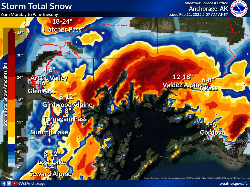
Predicted storm totals by tomorrow morning. Snowfall is expected to begin during the day today, with the heaviest periods of snow overnight. Graphic courtesy of NWS Anchorage.
Yesterday: We had another day of fair weather yesterday, with partly cloudy skies and high temperatures in the upper 20’s to mid 30’s F. Winds were light out of the west for most of the day at 5-10 mph with gusts at 10-15 mph, transitioning to southerly and easterly overnight with sustained speeds at 10-15 mph and gusts of 15-25 mph this morning. Low temperatures dropped to the teens to mid 20’s F overnight before starting to climb again early this morning.
Today: The next round of stormy weather arrives today. Easterly winds will pick up ahead of the heaviest precip, with sustained speeds of 30-45 mph and gusts of 45-50 mph by this afternoon. We are expecting 2-3″ snow during the day for Girdwood, Turnagain Pass, and Summit Lake, with 3-5″ in Portage and Placer during the day. Rain levels are expected to stay down around 100-300′ during the day before rising slightly overnight. Daytime high temperatures will be in the upper 20’s to low 30’s F.
Tomorrow: Heavier snowfall continues overnight, with totals around 6-12″ for Girdwood and Turnagain Pass, and 12-18″ in Portage and Placer by midday tomorrow. Strong winds will continue overnight, with sustained speeds at 30-50 mph and gusts of 40-60 mph, before starting to back off during the day tomorrow. Rain level is expected to rise to 300-500′ before the snow stops. Overnight low temperatures will hover in the upper 20’s to low 30’s F, with daytime highs in the low 30’s F.
PRECIPITATION 24-hour data (6am – 6am)
Temp Avg (F) | Snow (in) | Water (in) | Snow Depth (in) | |
---|---|---|---|---|
Center Ridge (1880′) | 29 | 0 | 0 | 92 |
Summit Lake (1400′) | 23 | 0 | 0 | 44 |
Alyeska Mid (1700′) | 28 | 0 | 0 | 96 |
RIDGETOP 24-hour data (6am – 6am)
Temp Avg (F) | Wind Dir | Wind Avg (mph) | Wind Gust (mph) | |
---|---|---|---|---|
Sunburst (3812′) | 24 | W-E* | 6 | 20 |
Seattle Ridge (2400′) | 27 | W-E* | 5 | 14 |
*Winds switched directions around 7 p.m. last night.
Date | Region | Location | Observer |
---|---|---|---|
05/22/23 | Turnagain | Avalanche: Tincan | Nick D'Alessio |
05/12/23 | Turnagain | Avalanche: Tincan, Sunburst, Magnum, Cornbiscuit | Heather Thamm |
05/07/23 | Turnagain | Observation: Tincan – Bear Tracks | CNFAIC Staff |
05/05/23 | Turnagain | Observation: Seattle Ridge | AS/ WW Forecaster |
05/02/23 | Turnagain | Observation: Cornbiscuit | Schauer/ Sturgess Forecaster |
05/02/23 | Turnagain | Observation: Seward Hwy Turnagain Pass | Joel Curtis |
04/30/23 | Turnagain | Observation: Magnum | Ayla, Kit Crosby, Barton |
04/29/23 | Turnagain | Observation: Tincan | John Sykes |
04/28/23 | Turnagain | Avalanche: Taylor Pass/Pastoral | Schauer/ Creighton Forecaster |
04/28/23 | Turnagain | Avalanche: Tincan | Andy Moderow |
Status of riding areas across the Chugach NF is managed by the Glacier and Seward Ranger Districts, not avalanche center staff. Riding area information is posted as a public service to our users and updated based on snow depth and snow density to prevent resource damage at trailhead locations. Riding area questions contact: mailroom_r10_chugach@fs.fed.us
Area | Status | Weather & Riding Conditions |
---|---|---|
Glacier District |
Subscribe to Turnagain Pass
Avalanche Forecast by Email
This is a general backcountry avalanche advisory issued for Turnagain Arm with Turnagain Pass as the core advisory area. This advisory does not apply to highways, railroads or operating ski areas.