Turnagain Pass Avalanche Forecast
|
![]() ![]() |
Today’s avalanche danger is MODERATE, and it is possible to trigger an avalanche on weak layers of snow buried 1-2’ deep. The most likely places to trigger an avalanche will be on steep slopes with stiff slabs near the surface. A dusting of light snow will make it more challenging to identify stiff slabs, so it will be important to be intentional with assessing the upper snowpack before committing to steep terrain.
Signal Word | Size (D scale) | Simple Descriptor |
Small | 1 | Unlikely to bury a person |
Large | 2 | Can bury a person |
Very Large | 3 | Can destroy a house |
Historic | 4 & 5 | Can destroy part or all of a village |
Today it is still possible to trigger an avalanche on weak layers of snow in the upper 2’ of the snowpack. These layers formed during dry spells in late January and early February, have recently produced avalanches (examples here and here) and continue to show poor results in stability tests. In some areas we are dealing with buried surface hoar, others are a combination of decomposing stellars and near-surface facets, and many places have both. These layers are particularly concerning where buried surface hoar sits on top of a rain crust at elevations up to 1200-2000′. The key to staying out of trouble today will be avoiding steep slopes where those weak layers are capped by stiff snow near the surface. A few inches of snow from last night will not increase the avalanche danger, but it may make it more difficult to identify slopes that were previously wind-loaded. You can still look for slabs as you travel, and it can be as easy as hopping off your machine and poking into the snow, or stepping off the skin track to probe around as you approach your objective.
Persistent weak layers will sometimes– not always– give clear warning signs prior to avalanching. If you notice shooting cracks or collapsing, these are sure signs that the snowpack is capable of avalanching and it is time to stick to low-angle terrain. These persistent weak layers become more difficult to anticipate in the absence of these warning signs. When we are dealing with uncertainty in the strength of the snowpack, and in the reactivity of persistent weak layers, it is important to increase our margin of safety by minimizing exposure to consequential terrain.
We are expecting to see more snow tonight and into tomorrow. Snow and winds are not expected to pick up until later tonight, but the active weather may increase avalanche danger. Pay attention to changing conditions later in the day today, keep your fingers crossed for snow, and stay tuned for more!
Sluffs: Be aware of dry loose avalanches on slopes that have been sheltered from the wind. While it is unlikely they would be big enough to bury a person, they can become dangerous if they carry you down steep slopes and into terrain traps.
Cornices: Large cornices have been peeling away from ridgelines, opening up large cracks. If you are traveling along ridges be sure to give them plenty of space, and minimize the amount of time you spend traveling below them.
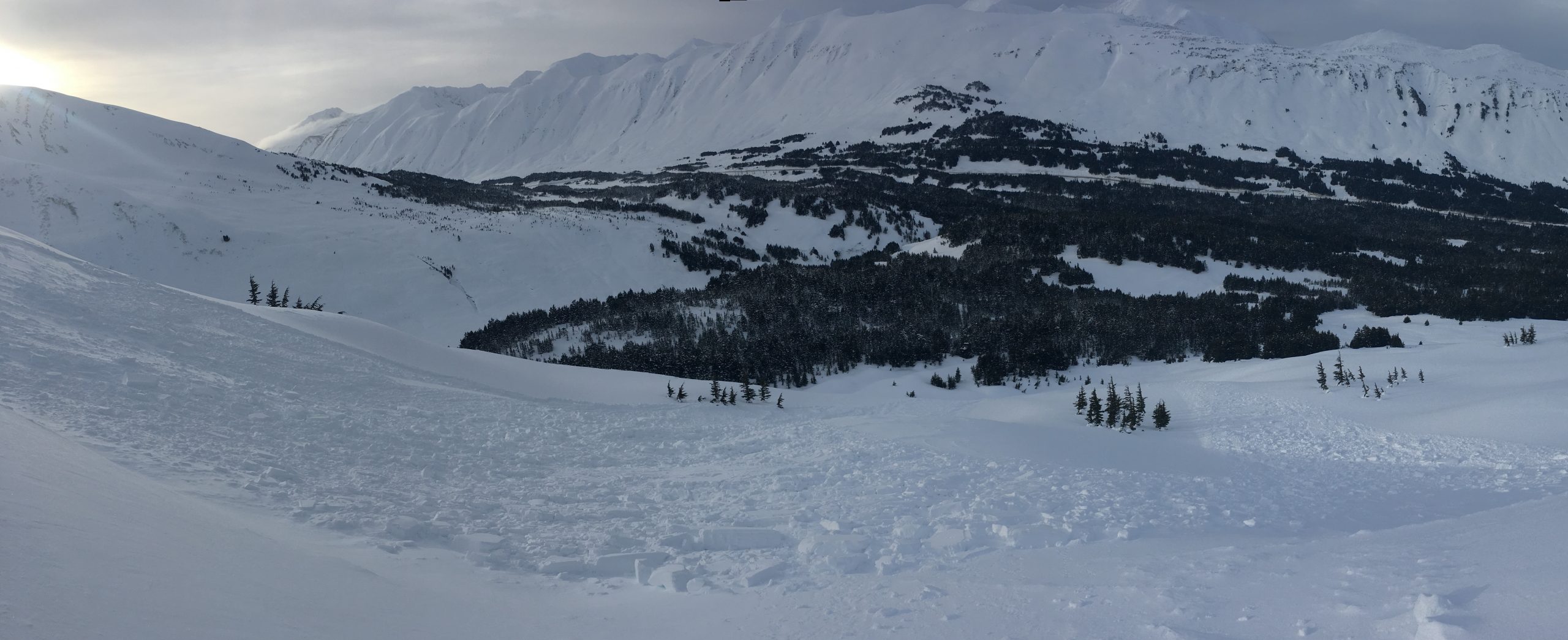
Looking down at the natural avalanche on Eddies (first observed on 02.12). The avalanche failed on a layer of buried surface hoar and near-surface facets about 12″ deep, and quickly stepped down to a deeper layer of buried surface hoar. 02.15.2021
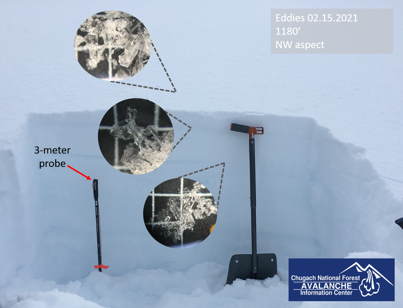
Two layers of buried surface hoar, plus a fresh layer on the surface which just got buried this morning. Eddies. 02.15.2021
Glide cracks have opened up throughout the area, and some are getting quite large. These avalanches are unpredictable and they are destructive since they involve the entire season’s snowpack. Avoid spending any time below glide cracks, as they can release unexpectedly. If you see any new glide activity, please let us know here.
Yesterday: High temperatures reached the upper 20’s to low 30’s F under mostly cloudy skies. Light easterly winds were blowing 5-10 mph at ridgetops, with gusts of 10-15 mph. Snow began trickling in last night, bringing 1-2” low-density snow by this morning, with snow to sea level.
Today: Snowfall is expected to turn off during the day today, with light easterly winds blowing 5-10 mph at ridgetops. Temperatures will be in the low- to upper 20’s F under mostly cloudy skies.
Tomorrow: We are expecting more snow and increased winds tonight, with another 3-7” possible by tomorrow morning, and winds 15-25 mph out of the east at ridgetops. Overnight low temperatures will be in the upper teens to low 20’s F, and high temperatures tomorrow will be in the mid 20’s to low 30’s F.
PRECIPITATION 24-hour data (6am – 6am)
Temp Avg (F) | Snow (in) | Water (in) | Snow Depth (in) | |
---|---|---|---|---|
Center Ridge (1880′) | 25 | 1 | tr | 116 |
Summit Lake (1400′) | 21 | 1 | 0.1 | 43 |
Alyeska Mid (1700′) | 25 | 3 | 0.15 | 111 |
RIDGETOP 24-hour data (6am – 6am)
Temp Avg (F) | Wind Dir | Wind Avg (mph) | Wind Gust (mph) | |
---|---|---|---|---|
Sunburst (3812′) | 20 | ESE | 4 | 10 |
Seattle Ridge (2400′) | 20 | E | 7 | 14 |
Date | Region | Location | Observer |
---|---|---|---|
05/22/23 | Turnagain | Avalanche: Tincan | Nick D'Alessio |
05/12/23 | Turnagain | Avalanche: Tincan, Sunburst, Magnum, Cornbiscuit | Heather Thamm |
05/07/23 | Turnagain | Observation: Tincan – Bear Tracks | CNFAIC Staff |
05/05/23 | Turnagain | Observation: Seattle Ridge | AS/ WW Forecaster |
05/02/23 | Turnagain | Observation: Cornbiscuit | Schauer/ Sturgess Forecaster |
05/02/23 | Turnagain | Observation: Seward Hwy Turnagain Pass | Joel Curtis |
04/30/23 | Turnagain | Observation: Magnum | Ayla, Kit Crosby, Barton |
04/29/23 | Turnagain | Observation: Tincan | John Sykes |
04/28/23 | Turnagain | Avalanche: Taylor Pass/Pastoral | Schauer/ Creighton Forecaster |
04/28/23 | Turnagain | Avalanche: Tincan | Andy Moderow |
Status of riding areas across the Chugach NF is managed by the Glacier and Seward Ranger Districts, not avalanche center staff. Riding area information is posted as a public service to our users and updated based on snow depth and snow density to prevent resource damage at trailhead locations. Riding area questions contact: mailroom_r10_chugach@fs.fed.us
Area | Status | Weather & Riding Conditions |
---|---|---|
Glacier District |
Subscribe to Turnagain Pass
Avalanche Forecast by Email
This is a general backcountry avalanche advisory issued for Turnagain Arm with Turnagain Pass as the core advisory area. This advisory does not apply to highways, railroads or operating ski areas.