Turnagain Pass RSS

Archives
ARCHIVED - Forecasts expire after 24 hours.
Issued
Thu, February 3rd, 2022 - 7:00AM
Expires
Fri, February 4th, 2022 - 7:00AM
Forecaster
John Sykes
Avalanche risk The Bottom Line

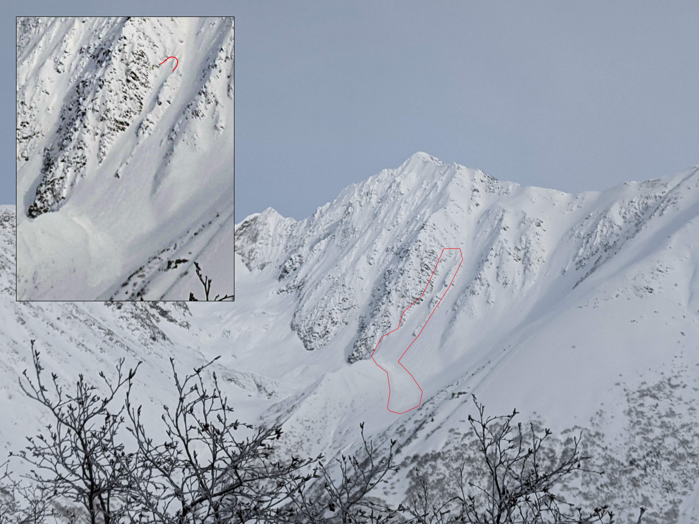
The avalanche danger is CONSIDERABLE above 1000′ today. Strong winds and 2-6″ of new snowfall will be building fresh wind slabs up to 2′ deep that are likely to be triggered by a person and possible to cause natural avalanches. Cautious route finding and conservative decision-making is recommended in areas that are seeing active wind loading. Keep an eye out for snow being transported onto leeward slopes, hollow feeling snow, and shooting cracks to help locate areas with fresh wind slabs.

Below 1000′ the avalanche danger is MODERATE. Below 700-1000′ the snowfall could transition to rain this afternoon which will create the potential for wet loose avalanches.

SUMMIT LAKE/LOST LAKE/SEWARD: Strong winds will impact these areas as well and fresh wind slabs can be expected at upper elevations.

Special Announcements
  • Winter Weather Advisory in effect for blowing snow and high winds until 6pm today
  • Forecaster Chat # 2: Join us virtually this TONIGHT, Feb. 3 from 6:00-7:30 p.m., for an interview with US Air Force Major Kevin Kelly of the Alaska Rescue Coordination Center. We’ll get his behind-the-scenes perspective of the role AKRCC plays in backcountry search and rescue missions, and try to share some tips on how to help facilitate an effective rescue should something go sideways in the backcountry. The virtual event is free, but registration is required. Click here for registration info and more details.
Thu, February 3rd, 2022
Alpine
Above 2,500'
3 - Considerable
Avalanche risk
Treeline
1,000'-2,500'
3 - Considerable
Avalanche risk
Below Treeline
Below 1,000'
2 - Moderate
Avalanche risk
0 - No Rating
1 - Low
2 - Moderate
3 - Considerable
4 - High
5 - Extreme
Avalanche risk Avalanche risk Avalanche risk Avalanche risk Avalanche risk
Travel Advice Generally safe avalanche conditions. Watch for unstable snow on isolated terrain features. Heightened avalanche conditions on specific terrain features. Evaluate snow and terrain carefully; identify features of concern. Dangerous avalanche conditions. Careful snowpack evaluation, cautious route-finding, and conservative decision-making essential. Very dangerous avalanche conditions. Travel in avalanche terrain not recommended. Extraordinarily dangerous avalanche conditions. Avoid all avalanche terrain.
Likelihood of Avalanches Natural and human-triggered avalanches unlikely. Natural avalanches unlikely; human-triggered avalanches possible. Natural avalanches possible; human-triggered avalanches likely. Natural avalanches likely; human-triggered avalanches very likely. Natural and human-triggered avalanches certain.
Avalanche Size and Distribution Small avalanches in isolated areas or extreme terrain. Small avalanches in specific areas; or large avalanches in isolated areas. Small avalanches in many areas; or large avalanches in specific areas; or very large avalanches in isolated areas. Large avalanches in many areas; or very large avalanches in specific areas. Very large avalanches in many areas.
Recent Avalanches

In the upper Girdwood valley yesterday we saw two fresh looking large debris piles in upper elevation terrain that looked like it could have come from avalanches released during the wind event on Tuesday. We didn’t get a close up look at either debris field and the light was too flat to see the crowns well, so it is hard to be confident about the exact age of these avalanches.

Avalanche debris and approximate release area (noted with red lines) on W aspect of Goat ridge at about 4000′. Photo 2.2.22

Avalanche Problem 1
  • Wind Slabs
    Wind Slabs
  • Certain
    Very Likely
    Likely
    Possible
    Unlikely
    Likelihood
  • Historic (D4-5)
    Very Large (D3)
    Large (D2)
    Small (D1)
    Size
Wind Slabs
Wind Slab avalanches are the release of a cohesive layer of snow (a slab) formed by the wind. Wind typically transports snow from the upwind sides of terrain features and deposits snow on the downwind side. Wind slabs are often smooth and rounded and sometimes sound hollow, and can range from soft to hard. Wind slabs that form over a persistent weak layer (surface hoar, depth hoar, or near-surface facets) may be termed Persistent Slabs or may develop into Persistent Slabs.

Likelihood of Avalanches
Terms such as "unlikely", "likely", and "certain" are used to define the scale, with the chance of triggering or observing avalanches increasing as we move up the scale. For our purposes, "Unlikely" means that few avalanches could be triggered in avalanche terrain and natural avalanches are not expected. "Certain" means that humans will be able to trigger avalanches on many slopes, and natural avalanches are expected.

Size of Avalanches
Avalanche size is defined by the largest potential avalanche, or expected range of sizes related to the problem in question. Assigned size is a qualitative estimate based on the destructive classification system and requires specialists to estimate the harm avalanches may cause to hypothetical objects located in the avalanche track (AAA 2016, CAA 2014). Under this schema, "Small" avalanches are not large enough to bury humans and are relatively harmless unless they carry people over cliffs or through trees or rocks. Moving up the scale, avalanches become "Large" enough to bury, injure, or kill people. "Very Large" avalanches may bury or destroy vehicles or houses, and "Historic" avalanches are massive events capable of altering the landscape.

Signal Word Size (D scale) Simple Descriptor
Small 1 Unlikely to bury a person
Large 2 Can bury a person
Very Large 3 Can destroy a house
Historic 4 & 5 Can destroy part or all of a village
More info at Avalanche.org

Another fast moving storm is passing through our area today, bringing strong winds averaging 15 – 40 mph with gusts into the 50’s at upper elevations and 2-6″ of new snow. Snow line will be moving up to 700 – 1000′ throughout the day. The main avalanche problem will be fresh wind slabs building at upper elevations with the strong winds and new snowfall today. These wind slabs are expected to be up to 2′ deep and will be likely to be triggered by a person and possible to release naturally. With the active weather today conservative terrain selection is recommended by avoiding being on or underneath areas with steep terrain being actively wind loaded. After the last round of winds on Tuesday there is not as much soft snow available for transport in common wind exposed terrain, but strong winds always seem to find some snow to transport.

Several observations from yesterday (here, here) noted that a small layer of surface hoar built up overnight on Wednesday which could cause the new snow falling today to not bond well with the existing snow surface in areas protected from the winds. With only 2-6″ of new snow expected this won’t be a major concern today but could be worth paying attention to as we move forward. In addition we have a couple buried weak layers in the snowpack that we have been tracking, including a thin freezing fog crust from 1.25 buried 1-3′ that produced a bunch of avalanches over the weekend and a layer of facets over the New Years Crust. Deeper avalanches on the freezing fog crust are possible as the wind loading and new snow add some stress to the layer. The New Years Crust is unlikely to produce avalanches at this point in time, but we have seen a few outlier avalanches on this layer and expect it is more likely to be reactive in areas with a thin overall snowpack such as in wind scoured terrain or areas with a shallower snowpack like along the southern boundary of the forecast zone.

Cornices: Another round of snow and winds will be building cornices further which means they could be touchy to human triggers today. Natural cornice fall is also possible today which has the potential to trigger an avalanche on the slope below.

Wind scoured ridgeline from Tuesday’s wind event with surface hoar on top that formed overnight Wednesday. Photo 2.2.22

Weather
Thu, February 3rd, 2022

Yesterday: Calm winds throughout the day with partly cloudy skies. Temperatures stayed in the teens to twenties. No new precipitation.

Today: Winds started to pick up just before midnight and have been averaging in the teens with gusts into the twenties since. They are expected to get up to 15 – 40 mph with gusts into the 50s today. A little bit of new snow is expected with 2 – 6″ of accumulation and snow line rising to 700 – 1000′ in the evening.

Tomorrow: Tomorrow looks like another calm period between storms with light winds and better visibility. No new snowfall is expected on Friday. The weekend looks stormy, with snowfall expected throughout but not much accumulation and winds staying mostly light to moderate. Stay tuned for updates on storm totals and freezing levels for the snowfall this weekend.

PRECIPITATION 24-hour data (6am – 6am)

Temp Avg (F) Snow (in) Water (in) Snow Depth (in)
Center Ridge (1880′) 22 0 0 91
Summit Lake (1400′) 15 0 0 34
Alyeska Mid (1700′) 20 0 0 84

RIDGETOP 24-hour data (6am – 6am)

Temp Avg (F) Wind Dir Wind Avg (mph) Wind Gust (mph)
Sunburst (3812′) 18 E 9 32
Seattle Ridge (2400′) 20 SE 7 26
Observations
Recent Observations for Turnagain Pass
Date Region Location
04/23/24 Turnagain Observation: Turnagain Sunny Side
04/21/24 Turnagain Observation: Bertha Creek
04/20/24 Turnagain Avalanche: Spokane Creek
04/16/24 Turnagain Observation: Cornbiscuit
04/15/24 Turnagain Observation: Taylor Pass
04/15/24 Turnagain Observation: Seward Highway – Tern Lake to Portage
04/14/24 Turnagain Observation: Sunburst
04/14/24 Turnagain Observation: Turnagain Pass Snomo
04/13/24 Turnagain Observation: Spokane Creek
04/11/24 Turnagain Observation: Tincan
Riding Areas

The riding areas page has moved. Please click here & update your bookmarks.


Subscribe to Turnagain Pass
Avalanche Forecast by Email

This is a general backcountry avalanche advisory issued for Turnagain Arm with Turnagain Pass as the core advisory area. This advisory does not apply to highways, railroads or operating ski areas.