Turnagain Pass Avalanche Forecast RSS

Archives
ARCHIVED FORECAST - All forecasts expire after 24 hours from the posting date/time.
Issued
Fri, February 4th, 2022 - 7:00AM
Expires
Sat, February 5th, 2022 - 7:00AM
Forecaster
Andrew Schauer
Avalanche risk The Bottom Line

The avalanche danger is MODERATE above 1000′. It is possible to trigger an avalanche 1-2′ deep on recently wind loaded slopes. Choose your terrain carefully, and be on the lookout for unstable snow near ridgelines, in gullies, or on the downhill side of convex rolls. The danger is LOW below 1000′.

Thanks to our sponsors!
Fri, February 4th, 2022
Alpine
Above 2,500'
Moderate (2)
Avalanche risk
Treeline
1,000'-2,500'
Moderate (2)
Avalanche risk
Below Treeline
Below 1,000'
Low (1)
Avalanche risk
Alpine
Above 2,500'
Avalanche risk
Moderate (2)
Treeline
1,000'-2,500'
Avalanche risk
Moderate (2)
Below Treeline
Below 1,000'
Avalanche risk
Low (1)
Danger Scale:
No Rating (0)
Low (1)
Moderate (2)
Considerable (3)
High (4)
Extreme (5)
Avalanche Problem 1
  • Wind Slabs
    Wind Slabs
  • Almost Certain
    Very Likely
    Likely
    Possible
    Unlikely
    Likelihood
  • Historic (D4-5)
    Very Large (D3)
    Large (D2)
    Small (D1)
    Size
Wind Slabs
Wind Slab avalanches are the release of a cohesive layer of snow (a slab) formed by the wind. Wind typically transports snow from the upwind sides of terrain features and deposits snow on the downwind side. Wind slabs are often smooth and rounded and sometimes sound hollow, and can range from soft to hard. Wind slabs that form over a persistent weak layer (surface hoar, depth hoar, or near-surface facets) may be termed Persistent Slabs or may develop into Persistent Slabs.

Likelihood of Avalanches
Terms such as "unlikely", "likely", and "certain" are used to define the scale, with the chance of triggering or observing avalanches increasing as we move up the scale. For our purposes, "Unlikely" means that few avalanches could be triggered in avalanche terrain and natural avalanches are not expected. "Certain" means that humans will be able to trigger avalanches on many slopes, and natural avalanches are expected.

Size of Avalanches
Avalanche size is defined by the largest potential avalanche, or expected range of sizes related to the problem in question. Assigned size is a qualitative estimate based on the destructive classification system and requires specialists to estimate the harm avalanches may cause to hypothetical objects located in the avalanche track (AAA 2016, CAA 2014). Under this schema, "Small" avalanches are not large enough to bury humans and are relatively harmless unless they carry people over cliffs or through trees or rocks. Moving up the scale, avalanches become "Large" enough to bury, injure, or kill people. "Very Large" avalanches may bury or destroy vehicles or houses, and "Historic" avalanches are massive events capable of altering the landscape.

Signal Word Size (D scale) Simple Descriptor
Small 1 Unlikely to bury a person
Large 2 Can bury a person
Very Large 3 Can destroy a house
Historic 4 & 5 Can destroy part or all of a village
More info at Avalanche.org

We are looking at a quiet day of weather today before things pick up again tomorrow, and the main concern will be triggering a wind slab avalanche on slopes that were loaded during yesterday’s snow and winds. With modest snow totals and easterly winds around 15-25 mph, these are expected to be around 1-2′ deep. Moderate winds persisted through late last night, which means the slabs that have formed will still be fairly fresh this morning, despite calm weather. We received multiple reports of pockets of surface hoar that had formed ahead of the storm, which can make isolated slopes especially reactive today.

Today’s avalanche danger may not be right in your face, but it should show some clues if you are looking for them. Pay attention to any signs of unstable snow, including shooting cracks, collapsing, and fresh avalanche activity. Take the time to hop off your machine or step off the skin track and poke in the snow, looking for evidence of recent wind loading. This may look like a textured surface, or a smooth pillowy drift. It will feel like a stiffer layer of snow above softer snow. The most suspect terrain will be steep slopes near ridgelines, on the downhill side of convexities, and in gullies. If you are unsure about the reactivity or distribution of wind slabs in the area you are traveling today, you can stay out of trouble by avoiding those features and stick to lower slope angles. We are still tracking multiple crusts in the upper 2-3′ of the snowpack, which seem to be very unlikely of producing avalanches at this point. However, it is worth keeping these lurking monsters in mind when choosing terrain, and maybe staying a bit more conservative than you would normally be with a lingering wind slab problem.

Cornices: Yesterday’s snow and winds continued to build large cornices. As always, be sure to keep plenty of space from the edge of cornices, as they commonly break further from ridgelines than people expect.

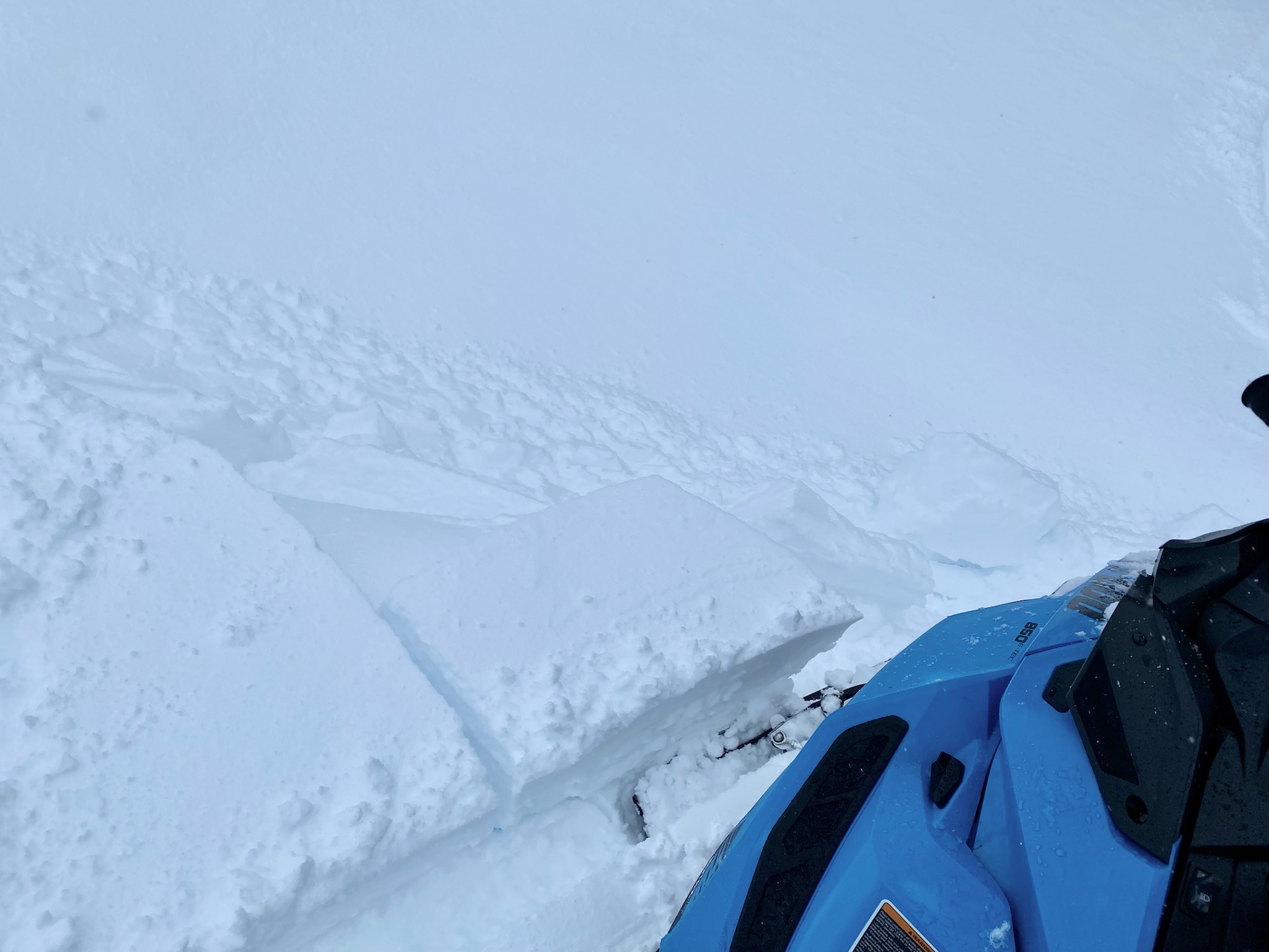
Chunks of wind slabs breaking on a small test slope yesterday. 02.03.2022

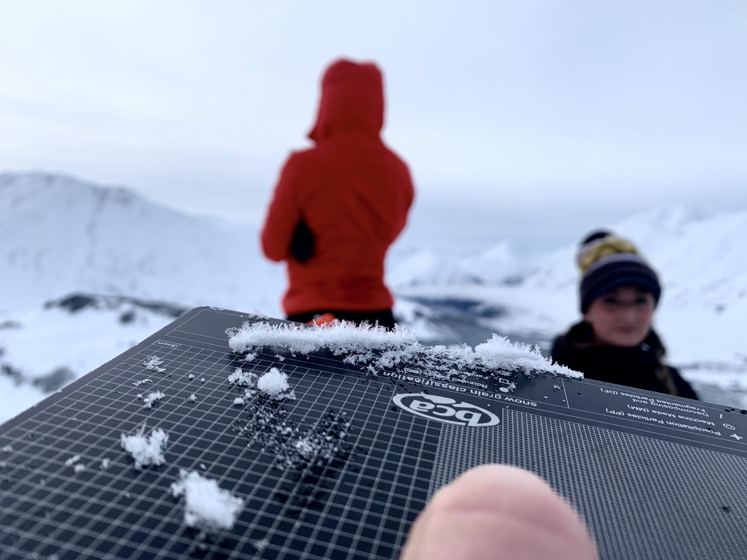
Small surface hoar crystals on Tincan Wednesday before the most recent round of snow and wind. This layer isn’t everywhere, but it might make some slopes more reactive today. Photo: Brooke Edwards, 02.02.2022


Weather
Fri, February 4th, 2022

Yesterday: Light snowfall brought 2-4″ accumulation through the day under overcast skies. Winds were moderate out of the east at 15-25 mph for most of the day, with gusts of 40-55 mph at ridgetops. The snow line stayed low, creeping up to 700′ as snow tapered off. High temperatures were in the upper 20’s to low 30’s F, with lows in the upper teens to mid 20’s F.

Today: We are expecting a quiet day of weather today before things become more active tomorrow, with mostly cloudy skies and light westerly winds at around 5 mph. Clouds are expected to break up just a little bit this afternoon before the next system starts to move in overnight tonight. Temperatures are expected to remain in the mid 20’s to low 30’s F today through tonight, with a trace of snow possible.

Tomorrow: Light snowfall will return tomorrow, with 1-3″ possible. Easterly winds will pick back up to 15-20 mph with gusts of 30-40 mph under cloudy skies. High temperatures are expected to stay in the upper 20’s to low 30’s F. The weather is looking to stay active for the next few days, with a series of weak systems moving through the area this weekend into early next week. Stay tuned for more!

PRECIPITATION 24-hour data (6am – 6am)

Temp Avg (F) Snow (in) Water (in) Snow Depth (in)
Center Ridge (1880′) 28 2 0.1 92
Summit Lake (1400′) 23 3 0.2 38
Alyeska Mid (1700′) 25 4 0.3 N/A

RIDGETOP 24-hour data (6am – 6am)

Temp Avg (F) Wind Dir Wind Avg (mph) Wind Gust (mph)
Sunburst (3812′) 21 ENE 11 56
Seattle Ridge (2400′) 24 SE 9 25
Observations
Recent Observations for Turnagain Pass
Date Region Location
05/22/23 Turnagain Avalanche: Tincan
05/12/23 Turnagain Avalanche: Tincan, Sunburst, Magnum, Cornbiscuit
05/07/23 Turnagain Observation: Tincan – Bear Tracks
05/05/23 Turnagain Observation: Seattle Ridge
05/02/23 Turnagain Observation: Cornbiscuit
05/02/23 Turnagain Observation: Seward Hwy Turnagain Pass
04/30/23 Turnagain Observation: Magnum
04/29/23 Turnagain Observation: Tincan
04/28/23 Turnagain Avalanche: Taylor Pass/Pastoral
04/28/23 Turnagain Avalanche: Tincan
Riding Areas
Updated Thu, June 01st, 2023

Status of riding areas across the Chugach NF is managed by the Glacier and Seward Ranger Districts, not avalanche center staff. Riding area information is posted as a public service to our users and updated based on snow depth and snow density to prevent resource damage at trailhead locations. Riding area questions contact: mailroom_r10_chugach@fs.fed.us

Area Status Weather & Riding Conditions
Glacier District
Johnson Pass
Closed
Closed May 15.
Placer River
Closed
Closed May 15.
Skookum Drainage
Closed
Will close to motorized use on April 1, 2023 per the National Forest Plan.
Turnagain Pass
Closed
Will close on June 1.
Twentymile
Closed
Scheduled closure May 1.
Seward District
Carter Lake
Closed
Scheduled closure May 1.
Lost Lake Trail
Closed
Scheduled closure May 1.
Primrose Trail
Closed
Scheduled closure May 1.
Resurrection Pass Trail
Closed
Closed to motorized use for the 2022/23 winter season per Forest Plan. Open next season.
Snug Harbor
Closed
Extended opening until May 15.
South Fork Snow River Corridor
Closed
Scheduled closure May 1.
Summit Lake
Closed
Scheduled closure May 1.

Subscribe to Turnagain Pass
Avalanche Forecast by Email

This is a general backcountry avalanche advisory issued for Turnagain Arm with Turnagain Pass as the core advisory area. This advisory does not apply to highways, railroads or operating ski areas.