Turnagain Pass Avalanche Forecast RSS

Archives
ARCHIVED FORECAST - All forecasts expire after 24 hours from the posting date/time.
Issued
Wed, January 27th, 2021 - 7:00AM
Expires
Thu, January 28th, 2021 - 7:00AM
Forecaster
Andrew Schauer
Avalanche risk The Bottom Line

Today’s avalanche danger will be MODERATE at elevations above 2500’, where it will be possible to trigger a wind slab avalanche up to a foot deep on steep, wind-exposed slopes. Avoid slopes that have seen recent wind loading, and pay attention to clear signs of instability like shooting cracks, collapsing, and recent avalanche activity. It will also be important to be aware of hazards from large cornices and increasingly large sluffs in steep terrain.

The danger will be LOW below 2500’, where minimal wind activity and less snow for transport will make human-triggered avalanches unlikely, but not impossible.

Special Announcements

Forecaster Chat #4: Snowmachine Specific- Head on a Swivel! Join us Tuesday, February 2nd from 7-8:30pm, for a VIRTUAL snowmachine-specific discussion with Graham Predeger and snowmachine educator and rider Tim Thomas from Haines. More info here. Stay tuned for a link to join the free virtual event.

Thanks to our sponsors!
Wed, January 27th, 2021
Alpine
Above 2,500'
Moderate (2)
Avalanche risk
Treeline
1,000'-2,500'
Low (1)
Avalanche risk
Below Treeline
Below 1,000'
Low (1)
Avalanche risk
Alpine
Above 2,500'
Avalanche risk
Moderate (2)
Treeline
1,000'-2,500'
Avalanche risk
Low (1)
Below Treeline
Below 1,000'
Avalanche risk
Low (1)
Danger Scale:
No Rating (0)
Low (1)
Moderate (2)
Considerable (3)
High (4)
Extreme (5)
Recent Avalanches

A skier triggered a wind slab avalanche in the Library yesterday. The slide took out a portion of the existing skin track while a second group was ascending, but luckily nobody was caught in the avalanche. See report HERE.

Skier-triggered wind slab avalanche in the Library yesterday, 01.26.2021. Photo from anonymous observer.

Avalanche Problem 1
  • Wind Slabs
    Wind Slabs
  • Almost Certain
    Very Likely
    Likely
    Possible
    Unlikely
    Likelihood
  • Historic (D4-5)
    Very Large (D3)
    Large (D2)
    Small (D1)
    Size
Wind Slabs
Wind Slab avalanches are the release of a cohesive layer of snow (a slab) formed by the wind. Wind typically transports snow from the upwind sides of terrain features and deposits snow on the downwind side. Wind slabs are often smooth and rounded and sometimes sound hollow, and can range from soft to hard. Wind slabs that form over a persistent weak layer (surface hoar, depth hoar, or near-surface facets) may be termed Persistent Slabs or may develop into Persistent Slabs.

Likelihood of Avalanches
Terms such as "unlikely", "likely", and "certain" are used to define the scale, with the chance of triggering or observing avalanches increasing as we move up the scale. For our purposes, "Unlikely" means that few avalanches could be triggered in avalanche terrain and natural avalanches are not expected. "Certain" means that humans will be able to trigger avalanches on many slopes, and natural avalanches are expected.

Size of Avalanches
Avalanche size is defined by the largest potential avalanche, or expected range of sizes related to the problem in question. Assigned size is a qualitative estimate based on the destructive classification system and requires specialists to estimate the harm avalanches may cause to hypothetical objects located in the avalanche track (AAA 2016, CAA 2014). Under this schema, "Small" avalanches are not large enough to bury humans and are relatively harmless unless they carry people over cliffs or through trees or rocks. Moving up the scale, avalanches become "Large" enough to bury, injure, or kill people. "Very Large" avalanches may bury or destroy vehicles or houses, and "Historic" avalanches are massive events capable of altering the landscape.

Signal Word Size (D scale) Simple Descriptor
Small 1 Unlikely to bury a person
Large 2 Can bury a person
Very Large 3 Can destroy a house
Historic 4 & 5 Can destroy part or all of a village
More info at Avalanche.org

We will have one more day of relatively quiet weather before the next round of precipitation moves in later tonight, and the avalanche conditions have not changed much over the past few days. There is still a possibility of triggering wind slab avalanches in steep, wind-exposed terrain. Increasing cloud cover may make larger objectives a bit more challenging today, but if you are planning on moving into bigger terrain, it will be important to identify and avoid wind-loaded slopes. Watch for visual clues of recent wind loading, like stiffer snow at the surface, smooth pillows of wind-drifted snow, or various wind-textured surfaces. Avoid steep terrain if you notice any clear indicators of instability such as shooting cracks, collapsing, or recent avalanche activity. The most likely places to find unstable snow will be just below ridgelines, or on convexities or cross-loaded gullies in alpine areas. This could be in areas like upper elevations on the skier side of the pass, the Seattle Ridge back bowls, or at higher elevations in the Girdwood valley.

Stay tuned for the forecast over the next few days– it is looking like we are headed back into an active weather pattern towards the end of the week.

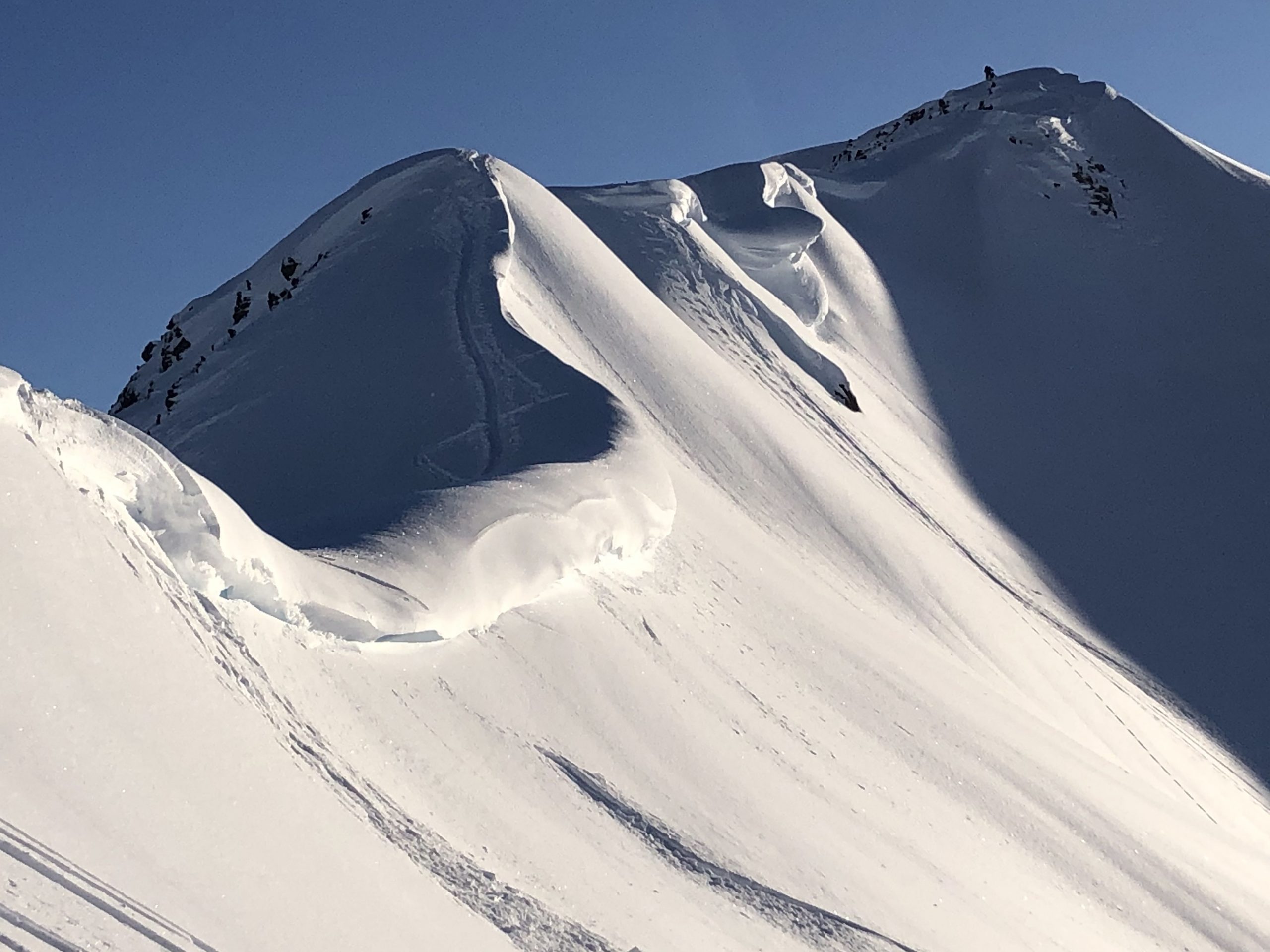
Cornices: If you are traveling along ridgelines, be sure to keep plenty of distance from the edge of the large cornices that have developed throughout the area. These things have a nasty tendency to break much further back than one would expect, and they are ready to fail under the weight of a snowmachine or a skier. It is also important to minimize time spent traveling below cornices, as there is a chance they could fail naturally.

Sluffs: There has been plenty of dry loose activity as folks have been accessing steeper terrain during these past few days of clear weather. We expect more of the same today on steep slopes. While it is unlikely a sluff would bury a person, they are getting plenty big enough to have serious consequences if they carry you over cliffs, rocks, or through trees.

Large cornices above Hippy Bowl, with chunks breaking off recently. Photo: Eric Roberts. 01.26.2021

Additional Concern
  • Glide Avalanches
    Glide Avalanches
Glide Avalanches
Glide Avalanches are the release of the entire snow cover as a result of gliding over the ground. Glide avalanches can be composed of wet, moist, or almost entirely dry snow. They typically occur in very specific paths, where the slope is steep enough and the ground surface is relatively smooth. They are often proceeded by full depth cracks (glide cracks), though the time between the appearance of a crack and an avalanche can vary between seconds and months. Glide avalanches are unlikely to be triggered by a person, are nearly impossible to forecast, and thus pose a hazard that is extremely difficult to manage.
More info at Avalanche.org

We have recently seen glide cracks open and release in the Girdwood valley, Turnagain and Summit Lake areas. These avalanches are unpredictable and large since they involve the entire snowpack. Let us know if you see any other cracks or releases, and be sure to avoid getting on or below slopes where you see them open up.

Weather
Wed, January 27th, 2021

Yesterday: Temperatures were in the upper teens to low 20’s F under clear skies with valley fog lingering all day. Winds were blowing 5-10 mph out of the west at ridgetops.

Today: Clouds are expected to begin to move in today as the high pressure ridge we have been enjoying gives way to a low pressure system moving in tonight. Temperatures will be in the mid teens to low 20’s during the day, and climb steadily to the upper teens to mid 20’s tonight. Easterly ridgetop winds will stay light, blowing at 5-10 mph.

Tomorrow: There is a chance for light snowfall tonight, which could bring 2-4″ snow. Temperatures should be cold enough to bring snow down to sea level, with highs in the low to mid- 20’s F. Easterly winds are expected to pick up to 15-25 mph at the ridgetops, with gusts to 30 mph.

PRECIPITATION 24-hour data (6am – 6am)

Temp Avg (F) Snow (in) Water (in) Snow Depth (in)
Center Ridge (1880′) 10 0 0 126
Summit Lake (1400′) 3 0 0 43
Alyeska Mid (1700′) 14 0 0 111

RIDGETOP 24-hour data (6am – 6am)

Temp Avg (F) Wind Dir Wind Avg (mph) Wind Gust (mph)
Sunburst (3812′) 16 W 7 17
Seattle Ridge (2400′) 11 NE 3 8
Observations
Recent Observations for Turnagain Pass
Date Region Location
05/22/23 Turnagain Avalanche: Tincan
05/12/23 Turnagain Avalanche: Tincan, Sunburst, Magnum, Cornbiscuit
05/07/23 Turnagain Observation: Tincan – Bear Tracks
05/05/23 Turnagain Observation: Seattle Ridge
05/02/23 Turnagain Observation: Cornbiscuit
05/02/23 Turnagain Observation: Seward Hwy Turnagain Pass
04/30/23 Turnagain Observation: Magnum
04/29/23 Turnagain Observation: Tincan
04/28/23 Turnagain Avalanche: Taylor Pass/Pastoral
04/28/23 Turnagain Avalanche: Tincan
Riding Areas
Updated Sat, September 23rd, 2023

Status of riding areas across the Chugach NF is managed by the Glacier and Seward Ranger Districts, not avalanche center staff. Riding area information is posted as a public service to our users and updated based on snow depth and snow density to prevent resource damage at trailhead locations. Riding area questions contact: mailroom_r10_chugach@fs.fed.us

Area Status Weather & Riding Conditions
Glacier District
Johnson Pass
Closed
Scheduled opening per Chugach National Forest plan December 1. Subject to adequate snow cover.
Placer River
Closed
Scheduled opening per Chugach National Forest plan December 1. Subject to adequate snow cover.
Skookum Drainage
Closed
Scheduled opening per Chugach National Forest plan December 1. Subject to adequate snow cover.
Turnagain Pass
Closed
Scheduled opening on the Wednesday before Thanksgiving per Chugach National Forest plan. Subject to adequate snow cover.
Twentymile
Closed
Scheduled opening per Chugach National Forest plan December 1. Subject to adequate snow cover.
Seward District
Carter Lake
Closed
Scheduled opening per Chugach National Forest plan December 1. Subject to adequate snow cover.
Lost Lake Trail
Closed
Scheduled opening per Chugach National Forest plan December 1. Subject to adequate snow cover.
Primrose Trail
Closed
Scheduled opening per Chugach National Forest plan December 1. Subject to adequate snow cover.
Resurrection Pass Trail
Closed
Scheduled opening per Chugach National Forest plan December 1. Subject to adequate snow cover.
Snug Harbor
Closed
Scheduled opening per Chugach National Forest plan December 1. Subject to adequate snow cover.
South Fork Snow River Corridor
Closed
Scheduled opening per Chugach National Forest plan December 1. Subject to adequate snow cover.
Summit Lake
Closed
Scheduled opening per Chugach National Forest plan December 1. Subject to adequate snow cover.

Subscribe to Turnagain Pass
Avalanche Forecast by Email

This is a general backcountry avalanche advisory issued for Turnagain Arm with Turnagain Pass as the core advisory area. This advisory does not apply to highways, railroads or operating ski areas.