Turnagain Pass RSS

Archives
ARCHIVED - Forecasts expire after 24 hours.
Issued
Sun, January 16th, 2022 - 7:00AM
Expires
Mon, January 17th, 2022 - 7:00AM
Forecaster
Andrew Schauer
Avalanche risk The Bottom Line

The avalanche danger remains CONSIDERABLE above 2500′, where a thick slab of snow from this week’s storms sits on top of weak snow buried 2-5′ deep. With limited access to the alpine since the snow started falling earlier in the week, it is unclear just how sensitive this setup will be to human triggers. As skies clear today, cautious route finding and conservative decision making are recommended while we gather more information about the potentially dangerous setup.

The danger is MODERATE between 1000′ and 2500′, where it is possible to trigger an avalanche 1-2′ deep on top of two crusts buried in the upper snowpack. Approach steep slopes with caution, and be on the lookout for clear signs of poor stability like shooting cracks, collapsing, and new avalanches.

The danger is LOW below 1000′, where snow surfaces are capped with a breakable crust and avalanches are unlikely.

Special Announcements

DOMAIN OUTAGE:  Avalanche center emails are not working currently.

The domain chugachavalanche.org is down due to a migration with the parent organization eNom. Please message avalanche center staff on Facebook or Instagram, or at the email wendy.wagner@usda.gov.

Sun, January 16th, 2022
Alpine
Above 2,500'
3 - Considerable
Avalanche risk
Treeline
1,000'-2,500'
2 - Moderate
Avalanche risk
Below Treeline
Below 1,000'
1 - Low
Avalanche risk
0 - No Rating
1 - Low
2 - Moderate
3 - Considerable
4 - High
5 - Extreme
Avalanche risk Avalanche risk Avalanche risk Avalanche risk Avalanche risk
Travel Advice Generally safe avalanche conditions. Watch for unstable snow on isolated terrain features. Heightened avalanche conditions on specific terrain features. Evaluate snow and terrain carefully; identify features of concern. Dangerous avalanche conditions. Careful snowpack evaluation, cautious route-finding, and conservative decision-making essential. Very dangerous avalanche conditions. Travel in avalanche terrain not recommended. Extraordinarily dangerous avalanche conditions. Avoid all avalanche terrain.
Likelihood of Avalanches Natural and human-triggered avalanches unlikely. Natural avalanches unlikely; human-triggered avalanches possible. Natural avalanches possible; human-triggered avalanches likely. Natural avalanches likely; human-triggered avalanches very likely. Natural and human-triggered avalanches certain.
Avalanche Size and Distribution Small avalanches in isolated areas or extreme terrain. Small avalanches in specific areas; or large avalanches in isolated areas. Small avalanches in many areas; or large avalanches in specific areas; or very large avalanches in isolated areas. Large avalanches in many areas; or very large avalanches in specific areas. Very large avalanches in many areas.
Avalanche Problem 1
  • Persistent Slabs
    Persistent Slabs
  • Certain
    Very Likely
    Likely
    Possible
    Unlikely
    Likelihood
  • Historic (D4-5)
    Very Large (D3)
    Large (D2)
    Small (D1)
    Size
Persistent Slabs
Persistent Slab avalanches are the release of a cohesive layer of snow (a slab) in the middle to upper snowpack, when the bond to an underlying persistent weak layer breaks. Persistent layers include: surface hoar, depth hoar, near-surface facets, or faceted snow. Persistent weak layers can continue to produce avalanches for days, weeks or even months, making them especially dangerous and tricky. As additional snow and wind events build a thicker slab on top of the persistent weak layer, this avalanche problem may develop into a Deep Persistent Slab.

Likelihood of Avalanches
Terms such as "unlikely", "likely", and "certain" are used to define the scale, with the chance of triggering or observing avalanches increasing as we move up the scale. For our purposes, "Unlikely" means that few avalanches could be triggered in avalanche terrain and natural avalanches are not expected. "Certain" means that humans will be able to trigger avalanches on many slopes, and natural avalanches are expected.

Size of Avalanches
Avalanche size is defined by the largest potential avalanche, or expected range of sizes related to the problem in question. Assigned size is a qualitative estimate based on the destructive classification system and requires specialists to estimate the harm avalanches may cause to hypothetical objects located in the avalanche track (AAA 2016, CAA 2014). Under this schema, "Small" avalanches are not large enough to bury humans and are relatively harmless unless they carry people over cliffs or through trees or rocks. Moving up the scale, avalanches become "Large" enough to bury, injure, or kill people. "Very Large" avalanches may bury or destroy vehicles or houses, and "Historic" avalanches are massive events capable of altering the landscape.

Signal Word Size (D scale) Simple Descriptor
Small 1 Unlikely to bury a person
Large 2 Can bury a person
Very Large 3 Can destroy a house
Historic 4 & 5 Can destroy part or all of a village
More info at Avalanche.org

We are expecting to see the skies clear today for the first time in over a week. With quiet weather for the next few days, our main focus is on the two crusts buried in the upper snowpack. The upper crust formed after temperatures warmed at the end of the 1/10 storm event. It is buried 1-2′ deep and exists at elevations up to around 1800-2000′. This layer was showing up with poor stability test results in snowpits on Friday (see these observations from Tincan and Seattle Ridge for more details). Despite the poor test results, we have seen very limited activity on this interface so far. The second layer of concern is the weak snow on top of the New Year’s crust, which is now buried 2-4′ deep in most places, and up to 5′ deep or deeper on slopes that were loaded with the strong winds from earlier in the week. This layer appears to be gaining strength, but we still have very limited info on how it is behaving in the alpine.

The avalanche problem today is tricky. We know there are two suspect layers in the upper snowpack, which we have very limited information on in the alpine. Because of this potential for large to very large avalanches, and the high level of uncertainty we are currently dealing with in the upper elevations, we recommend cautious route finding today. The clear weather will be a good opportunity to gather more information and assess just how sensitive or stubborn these weak layers are. For now, we need to treat them as guilty until proven innocent.

If you are planning on getting out today, be on the lookout for clear warning signs of poor stability like shooting cracks, collapsing, and fresh avalanche activity. Give yourself a wide margin of safety by avoiding traveling on or below steep slopes. Be extra cautious around previously wind-loaded slopes with firm snow on the surface. These hard slabs can make it possible to venture out into the middle of a slope before triggering an avalanche, making it very difficult to avoid getting carried if you were to trigger an avalanche.

As we look at the first sunny day in over a week, which happens to fall on a weekend, there will be a lot of potential triggers (i.e. humans) out in the mountains. If we all dive right into big, steep terrain, there is a good chance somebody will run into trouble. Use today to assess the strength of the snowpack, and keep terrain choices mellow until we get more feedback on how the snow is responding to the heavy load from this week.

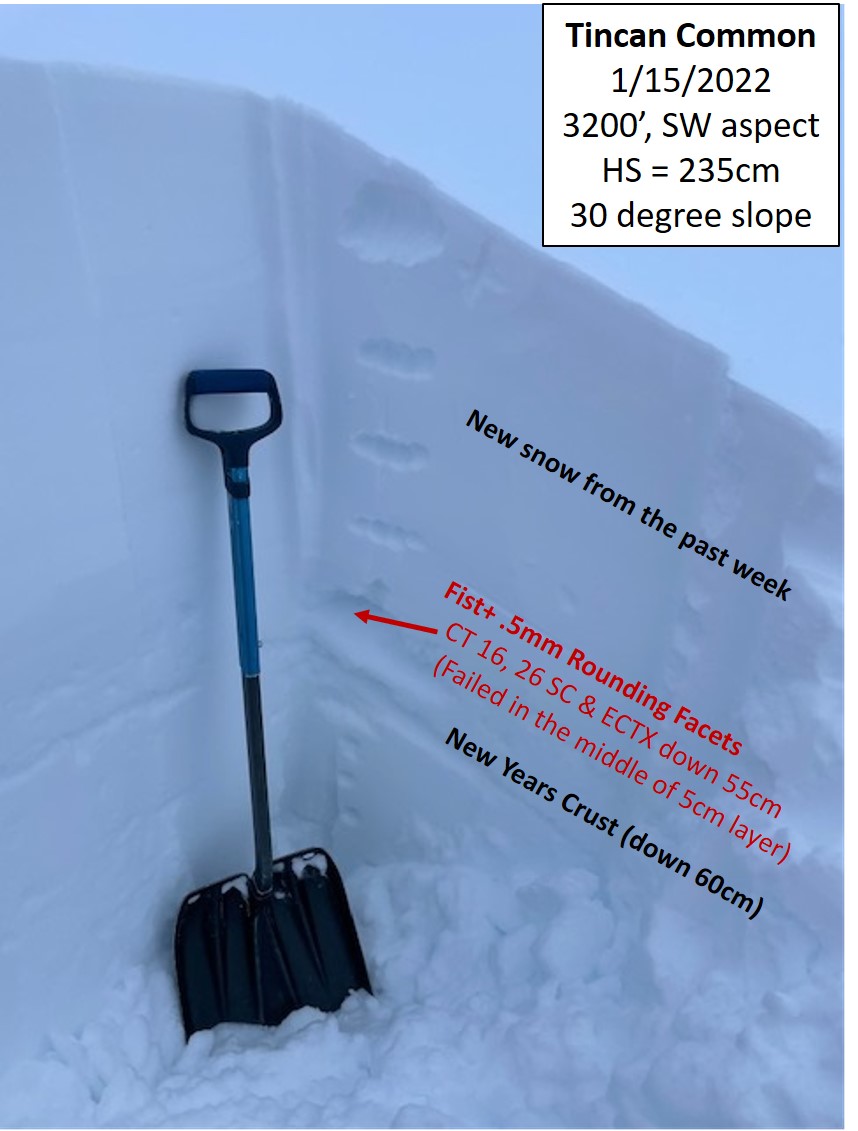
This snowpit is one of our very few data points from the alpine since heavy snow began last Sunday evening. The stability test results (in red) show the weak snow above the New Year’s crust is gaining strength, but still shows the potential to avalanche. Photo: Andy Moderow, 01.15.2022

Approximate outline of a large avalanche on the west face of Pyramid,  first noted on Friday afternoon. The avalanche failed during or immediately after the 1/13 storm, and likely ran on one of the two surfaces we suspect may still be capable of producing large avalanches today. Photo taken 01.15.2022.

Weather
Sun, January 16th, 2022

Yesterday: Skies remained cloudy, with some brief periods where it looked like the sun might poke through. Light snowfall picked up in the afternoon, with some short periods of heavy snow. Weather stations this morning are showing 4″ new snow in Girdwood, 2″ in Turnagain Pass, and 3″ at Summit Lake. Winds were light out of the east at 5-10 mph during the day, shifting westerly and staying at 5-10 mph overnight. Temperatures were in the upper 20’s to low 30’s F, and have slowly been dropping overnight down to the upper teens to low 20’s F as of 6:00 this morning.

Today: Clouds are expected to break up late this morning, with mostly clear skies expected by early afternoon. Temperatures are expected to stay in the upper teens F, with light northwesterly winds at 5-10 mph, gusting to 10-15 mph. No precipitation is expected today. Overnight lows are expected to drop down to the low teens F.

Tomorrow: The weather is expected to stay quiet and cool tomorrow, with partly cloudy skies and high temperatures in the upper teens F. Winds are looking to shift back out of the southeast as an upper-level low passes, but they should stay light at 5-10 mph. No precipitation is expected.

PRECIPITATION 24-hour data (6am – 6am)

Temp Avg (F) Snow (in) Water (in) Snow Depth (in)
Center Ridge (1880′) 28 2 0.2 82
Summit Lake (1400′) 24 3 0.1 30
Alyeska Mid (1700′) 28 4 0.2 N/A

RIDGETOP 24-hour data (6am – 6am)

Temp Avg (F) Wind Dir Wind Avg (mph) Wind Gust (mph)
Sunburst (3812′) 20 ENE-WNW 7 28
Seattle Ridge (2400′) 24 N/A N/A N/A

Seattle ridge anemometer is covered in rime and not reporting data.

Observations
Recent Observations for Turnagain Pass
Date Region Location
04/21/24 Turnagain Observation: Bertha Creek
04/20/24 Turnagain Avalanche: Spokane Creek
04/16/24 Turnagain Observation: Cornbiscuit
04/15/24 Turnagain Observation: Taylor Pass
04/15/24 Turnagain Observation: Seward Highway – Tern Lake to Portage
04/14/24 Turnagain Observation: Sunburst
04/14/24 Turnagain Observation: Turnagain Pass Snomo
04/13/24 Turnagain Observation: Spokane Creek
04/11/24 Turnagain Observation: Tincan
04/10/24 Turnagain Avalanche: Seattle Ridge
Riding Areas

The riding areas page has moved. Please click here & update your bookmarks.


Subscribe to Turnagain Pass
Avalanche Forecast by Email

This is a general backcountry avalanche advisory issued for Turnagain Arm with Turnagain Pass as the core advisory area. This advisory does not apply to highways, railroads or operating ski areas.