Turnagain Pass RSS

Archives
ARCHIVED - Forecasts expire after 24 hours.
Issued
Sat, January 15th, 2022 - 7:00AM
Expires
Sun, January 16th, 2022 - 7:00AM
Forecaster
John Sykes
Avalanche risk The Bottom Line

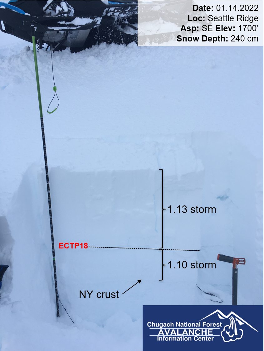
The avalanche danger remains CONSIDERABLE above 1000′ today. Strong winds and plenty of new snow this week has made it likely for a person to trigger an avalanche 2-5′ deep on wind loaded slopes. In wind protected areas human triggered avalanches are possible on a layer of weak sugary snow above a buried crust about 2′ deep, or where the 1-2′ of new snow from Thursday is not bonding well to the old snow surface. Cautious route finding and snowpack assessment are recommended before venturing into avalanche terrain.

Below 1000′ the avalanche danger remains MODERATE. This elevation band has seen mostly rain during the recent storms and the potential exists for wet loose avalanches in steep terrain. As the temperatures gradually drop later today the snow surface may start to freeze which will strengthen the snowpack at these elevations.

Special Announcements
  • Chugach State Park – We were informed of a large avalanche on the Flattop trail which is an indication of dangerous avalanche conditions in the area. Be cautious travelling on or under steep slopes, especially if they appear to have been recently wind loaded. Limited information is available about the snowpack conditions in this area.
Sat, January 15th, 2022
Alpine
Above 2,500'
3 - Considerable
Avalanche risk
Treeline
1,000'-2,500'
3 - Considerable
Avalanche risk
Below Treeline
Below 1,000'
2 - Moderate
Avalanche risk
0 - No Rating
1 - Low
2 - Moderate
3 - Considerable
4 - High
5 - Extreme
Avalanche risk Avalanche risk Avalanche risk Avalanche risk Avalanche risk
Travel Advice Generally safe avalanche conditions. Watch for unstable snow on isolated terrain features. Heightened avalanche conditions on specific terrain features. Evaluate snow and terrain carefully; identify features of concern. Dangerous avalanche conditions. Careful snowpack evaluation, cautious route-finding, and conservative decision-making essential. Very dangerous avalanche conditions. Travel in avalanche terrain not recommended. Extraordinarily dangerous avalanche conditions. Avoid all avalanche terrain.
Likelihood of Avalanches Natural and human-triggered avalanches unlikely. Natural avalanches unlikely; human-triggered avalanches possible. Natural avalanches possible; human-triggered avalanches likely. Natural avalanches likely; human-triggered avalanches very likely. Natural and human-triggered avalanches certain.
Avalanche Size and Distribution Small avalanches in isolated areas or extreme terrain. Small avalanches in specific areas; or large avalanches in isolated areas. Small avalanches in many areas; or large avalanches in specific areas; or very large avalanches in isolated areas. Large avalanches in many areas; or very large avalanches in specific areas. Very large avalanches in many areas.
Recent Avalanches
  • Wolverine – Andrew saw a couple large natural avalanches in a W facing bowl on Wolverine around 2500′ while driving down from the pass yesterday afternoon. Light was fading so he didn’t get a photo, but his best guess is that they were 3-4′ deep and the biggest one was 750′ wide. Due to limited visibility the last few days we have not been able to see much activity in upper elevations, so we don’t know how widespread this type of activity is.
  • Tincan – Skier triggered pocket of storm slab at ~2000′ near Treeline. Avalanche was about 18″ deep and did not propagate very widely, skier was able to ride out of the avalanche.
  • Front side of Seattle Ridge – Snowmachine triggered small storm slab at 1300′.

Small storm slab avalanche triggered by a snowmachine on 1.14.22 

Avalanche Problem 1
  • Wind Slabs
    Wind Slabs
  • Certain
    Very Likely
    Likely
    Possible
    Unlikely
    Likelihood
  • Historic (D4-5)
    Very Large (D3)
    Large (D2)
    Small (D1)
    Size
Wind Slabs
Wind Slab avalanches are the release of a cohesive layer of snow (a slab) formed by the wind. Wind typically transports snow from the upwind sides of terrain features and deposits snow on the downwind side. Wind slabs are often smooth and rounded and sometimes sound hollow, and can range from soft to hard. Wind slabs that form over a persistent weak layer (surface hoar, depth hoar, or near-surface facets) may be termed Persistent Slabs or may develop into Persistent Slabs.

Likelihood of Avalanches
Terms such as "unlikely", "likely", and "certain" are used to define the scale, with the chance of triggering or observing avalanches increasing as we move up the scale. For our purposes, "Unlikely" means that few avalanches could be triggered in avalanche terrain and natural avalanches are not expected. "Certain" means that humans will be able to trigger avalanches on many slopes, and natural avalanches are expected.

Size of Avalanches
Avalanche size is defined by the largest potential avalanche, or expected range of sizes related to the problem in question. Assigned size is a qualitative estimate based on the destructive classification system and requires specialists to estimate the harm avalanches may cause to hypothetical objects located in the avalanche track (AAA 2016, CAA 2014). Under this schema, "Small" avalanches are not large enough to bury humans and are relatively harmless unless they carry people over cliffs or through trees or rocks. Moving up the scale, avalanches become "Large" enough to bury, injure, or kill people. "Very Large" avalanches may bury or destroy vehicles or houses, and "Historic" avalanches are massive events capable of altering the landscape.

Signal Word Size (D scale) Simple Descriptor
Small 1 Unlikely to bury a person
Large 2 Can bury a person
Very Large 3 Can destroy a house
Historic 4 & 5 Can destroy part or all of a village
More info at Avalanche.org

It has been an active week for weather in the forecast area with 2-3′ of new snow in Turnagain Pass and 3-4′ in Girdwood over the course of the week. Strong east winds accompanied the recent snowfall and continued to transport snow at upper elevations with gusts up to 50 mph at ridgetops until yesterday afternoon. Cloud cover has obscured our ability to see recent avalanches at upper elevations all week, so we don’t have much information from above 2000′. We expect that the combination of lots of new snow and strong E winds have created large wind slabs 2-5′ deep at upper elevations which will be possible for a person to trigger.

Look for signs of recent wind transport on the snow surface, pillows of new snow on leeward aspects, and fresh cornices to identify wind loaded slopes. Due to the strength of the winds this week wind slabs could extend lower down onto a slope than normal. We recommend cautious route finding and assessing the snowpack and terrain carefully before exposing yourself to avalanche terrain today. Small test slopes are a very effective way to check how reactive wind slabs are before stepping into more consequential terrain. A few inches of new snow is supposed to fall with light winds today which could make identifying wind loaded areas much more difficult. If this is the case, feeling for hollow snow under your skis/board or sled track and stopping to dig hand pits or use a ski pole to test the surface layers of snow can be an effective way to identify wind loaded slopes.

Snowfall totals from this week have been variable across the forecast zone, with much higher totals observed in Girdwood compared to Turnagain Pass. We have no information from Placer and Portage but expect that they were on the high end of snowfall this week, with up to 4′ of new snow. If you venture into these areas today be aware that wind slabs could be on the deeper side of the 2-5′ range and that weak layers could be buried more deeply than we have seen in Turnagain Pass (see problem 2 for more details).

Avalanche Problem 2
  • Persistent Slabs
    Persistent Slabs
  • Certain
    Very Likely
    Likely
    Possible
    Unlikely
    Likelihood
  • Historic (D4-5)
    Very Large (D3)
    Large (D2)
    Small (D1)
    Size
Persistent Slabs
Persistent Slab avalanches are the release of a cohesive layer of snow (a slab) in the middle to upper snowpack, when the bond to an underlying persistent weak layer breaks. Persistent layers include: surface hoar, depth hoar, near-surface facets, or faceted snow. Persistent weak layers can continue to produce avalanches for days, weeks or even months, making them especially dangerous and tricky. As additional snow and wind events build a thicker slab on top of the persistent weak layer, this avalanche problem may develop into a Deep Persistent Slab.

Likelihood of Avalanches
Terms such as "unlikely", "likely", and "certain" are used to define the scale, with the chance of triggering or observing avalanches increasing as we move up the scale. For our purposes, "Unlikely" means that few avalanches could be triggered in avalanche terrain and natural avalanches are not expected. "Certain" means that humans will be able to trigger avalanches on many slopes, and natural avalanches are expected.

Size of Avalanches
Avalanche size is defined by the largest potential avalanche, or expected range of sizes related to the problem in question. Assigned size is a qualitative estimate based on the destructive classification system and requires specialists to estimate the harm avalanches may cause to hypothetical objects located in the avalanche track (AAA 2016, CAA 2014). Under this schema, "Small" avalanches are not large enough to bury humans and are relatively harmless unless they carry people over cliffs or through trees or rocks. Moving up the scale, avalanches become "Large" enough to bury, injure, or kill people. "Very Large" avalanches may bury or destroy vehicles or houses, and "Historic" avalanches are massive events capable of altering the landscape.

Signal Word Size (D scale) Simple Descriptor
Small 1 Unlikely to bury a person
Large 2 Can bury a person
Very Large 3 Can destroy a house
Historic 4 & 5 Can destroy part or all of a village
More info at Avalanche.org

In addition to the wind slabs at upper elevations, there are a few potential persistent weak layers in the snowpack that have been showing signs of instability during our field tests this week. Both these layers are within the upper 3′ of the snowpack, but could be deeper in wind loaded areas, and are related to recently formed ice crusts. The most concerning layer is the New Years crust, which formed during a warm spell between Christmas and New Years and exists up to ~5000′ in elevation. Prior to the start of snowfall this week this layer had a mix of small facets and surface hoar on top of it which we expected would become a problem once a new load was applied to the snowpack. So far we have not observed widespread avalanche activity on this layer in the backcountry but have limited information due to lack of visibility. Yesterday at lower elevations on Tincan the New Years crust was buried about 2′ deep and showed signs of propagation potential in stability tests.

Another crust that exists between the two storm snow events from this week has been showing signs of propagation potential in some stability tests and is buried about 1-1.5′ deep at lower elevations. This crust formed at the end of the 1/10 snowfall event as wet snow fell up to about 2000′. The 1-2′ of new storm snow that fell on 1/13 has been showing signs that it is not bonding well with this icy surface and could be a weak layer for avalanches releasing underneath this most recent storm snow. We recommend evaluating the snowpack carefully before venturing into steep terrain today and being aware that the distribution of ice crusts varies with elevation, so it is important to assess the snowpack in an area that has similar aspect and elevation to where you want to enter avalanche terrain.

Stability tests showing propagation on ice crust underneath recent storm snow from front side of Seattle Ridge. Photo 1.14.22

Weather
Sat, January 15th, 2022

Yesterday: Light snow or rain on and off throughout the day with 0.2″ of water at Center Ridge SNOTEL and Alyeska mid-mountain station. Snow was dry above ~1400′ at Turnagain pass. Moderate winds and strong gusts up to 50 mph at the ridgetops during the day, and then tapering off to light winds overnight. Temperatures stayed relatively warm yesterday, hovering around freezing at 1500-1800′.

Today: Another pulse of precipitation is arriving this morning with 2-5″ of snow expected throughout the day and snow level starting at 500′ and dropping throughout the day as temperatures drop. Snow totals should be higher in Girdwood, with 5-10″ of snow possible. Winds should be in the 5-20 mph range out of the SE.

Tomorrow: Snowfall tapers off overnight tonight with minimal additional accumulation and clearing skies. Tomorrow looks like the first day with good visibility in awhile and temperatures should stay in the upper teens to twenties. Winds will shift to the W overnight and remain light through early next week.

PRECIPITATION 24-hour data (6am – 6am)

Temp Avg (F) Snow (in) Water (in) Snow Depth (in)
Center Ridge (1880′) 32 0 0.2 82
Summit Lake (1400′) 25 0 0 27
Alyeska Mid (1700′) 31 2 0.2 NA

RIDGETOP 24-hour data (6am – 6am)

Temp Avg (F) Wind Dir Wind Avg (mph) Wind Gust (mph)
Sunburst (3812′) 23 E 12 49
Seattle Ridge (2400′) 26 NA NA NA

* Seattle ridge wind sensor has rimed over, we will try to free it as soon as possible.

Observations
Recent Observations for Turnagain Pass
Date Region Location
04/16/24 Turnagain Observation: Cornbiscuit
04/15/24 Turnagain Observation: Taylor Pass
04/15/24 Turnagain Observation: Seward Highway – Tern Lake to Portage
04/14/24 Turnagain Observation: Sunburst
04/14/24 Turnagain Observation: Turnagain Pass Snomo
04/13/24 Turnagain Observation: Spokane Creek
04/11/24 Turnagain Observation: Tincan
04/10/24 Turnagain Avalanche: Seattle Ridge
04/10/24 Turnagain Observation: Cornbiscuit South Face
04/10/24 Turnagain Avalanche: Tincan
Riding Areas

The riding areas page has moved. Please click here & update your bookmarks.


Subscribe to Turnagain Pass
Avalanche Forecast by Email

This is a general backcountry avalanche advisory issued for Turnagain Arm with Turnagain Pass as the core advisory area. This advisory does not apply to highways, railroads or operating ski areas.