Turnagain Pass RSS

Archives
ARCHIVED - Forecasts expire after 24 hours.
Issued
Sat, January 16th, 2021 - 7:00AM
Expires
Sun, January 17th, 2021 - 7:00AM
Forecaster
Wendy Wagner
Avalanche risk The Bottom Line

The avalanche danger is CONSIDERABLE above 1,000′ due to another round of strong east wind with 6-10″ of new snow forecast today. Human triggered wind slab and storm slab avalanches are likely on slopes 35 degrees and steeper. Wind slabs, along with cornice falls, could release on their own. Wind slabs are expected to be in the 1-3′ range and touchy. The danger is MODERATE below 1,000′ where rain on snow will make human triggered wet loose snow avalanches possible. Cautious route-finding and conservative decision-making are essential again today.

SUMMIT LAKE: Only a couple inches of snow fell in Summit Lake yesterday morning and 2-3″ is expected today. This area has a much thinner and weaker snowpack. Any significant wind loading today could cause wind slabs to step-down into older layers.

LOST LAKE/SNUG: Little information is known regarding the snowpack and new snow amounts for the central Kenai Mtns and near Seward. Please use extra caution and let us know what you see by submitting a quick report HERE.

Special Announcements
  • Forecaster chat #3– TONIGHT, 6pm – With bonus Ski Giveaway winners announced. Join CNFAIC forecaster Andrew Schauer along with special guest Karl Birkeland from the National Avalanche Center as they talk about how an avalanche forecast is created and how to use it in the mountains!
  • Headed to Hatcher Pass? Be sure to read HPAC’s Saturday morning forecast.
Sat, January 16th, 2021
Alpine
Above 2,500'
3 - Considerable
Avalanche risk
Treeline
1,000'-2,500'
3 - Considerable
Avalanche risk
Below Treeline
Below 1,000'
2 - Moderate
Avalanche risk
0 - No Rating
1 - Low
2 - Moderate
3 - Considerable
4 - High
5 - Extreme
Avalanche risk Avalanche risk Avalanche risk Avalanche risk Avalanche risk
Travel Advice Generally safe avalanche conditions. Watch for unstable snow on isolated terrain features. Heightened avalanche conditions on specific terrain features. Evaluate snow and terrain carefully; identify features of concern. Dangerous avalanche conditions. Careful snowpack evaluation, cautious route-finding, and conservative decision-making essential. Very dangerous avalanche conditions. Travel in avalanche terrain not recommended. Extraordinarily dangerous avalanche conditions. Avoid all avalanche terrain.
Likelihood of Avalanches Natural and human-triggered avalanches unlikely. Natural avalanches unlikely; human-triggered avalanches possible. Natural avalanches possible; human-triggered avalanches likely. Natural avalanches likely; human-triggered avalanches very likely. Natural and human-triggered avalanches certain.
Avalanche Size and Distribution Small avalanches in isolated areas or extreme terrain. Small avalanches in specific areas; or large avalanches in isolated areas. Small avalanches in many areas; or large avalanches in specific areas; or very large avalanches in isolated areas. Large avalanches in many areas; or very large avalanches in specific areas. Very large avalanches in many areas.
Recent Avalanches

One avalanche was reported yesterday. It was in the Girdwood Valley (Notch Mtn) and was a skier triggered shallow 6″ thick soft slab that propagated on a rollover (photo below).

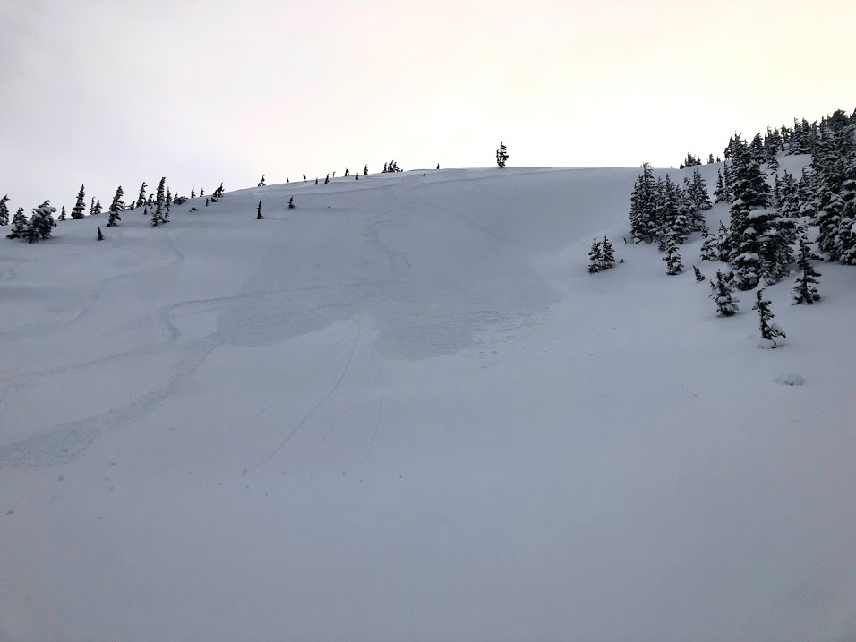
Shallow soft slab, skier triggered, in the Notch Mtn area of Girdwood Valley. Although too small to catch and bury a person, additional snowfall today may create a larger slab, big enough to cause grief. 1.15.21. Photo: Peter Symmes.

Avalanche Problem 1
  • Wind Slabs
    Wind Slabs
  • Certain
    Very Likely
    Likely
    Possible
    Unlikely
    Likelihood
  • Historic (D4-5)
    Very Large (D3)
    Large (D2)
    Small (D1)
    Size
Wind Slabs
Wind Slab avalanches are the release of a cohesive layer of snow (a slab) formed by the wind. Wind typically transports snow from the upwind sides of terrain features and deposits snow on the downwind side. Wind slabs are often smooth and rounded and sometimes sound hollow, and can range from soft to hard. Wind slabs that form over a persistent weak layer (surface hoar, depth hoar, or near-surface facets) may be termed Persistent Slabs or may develop into Persistent Slabs.

Likelihood of Avalanches
Terms such as "unlikely", "likely", and "certain" are used to define the scale, with the chance of triggering or observing avalanches increasing as we move up the scale. For our purposes, "Unlikely" means that few avalanches could be triggered in avalanche terrain and natural avalanches are not expected. "Certain" means that humans will be able to trigger avalanches on many slopes, and natural avalanches are expected.

Size of Avalanches
Avalanche size is defined by the largest potential avalanche, or expected range of sizes related to the problem in question. Assigned size is a qualitative estimate based on the destructive classification system and requires specialists to estimate the harm avalanches may cause to hypothetical objects located in the avalanche track (AAA 2016, CAA 2014). Under this schema, "Small" avalanches are not large enough to bury humans and are relatively harmless unless they carry people over cliffs or through trees or rocks. Moving up the scale, avalanches become "Large" enough to bury, injure, or kill people. "Very Large" avalanches may bury or destroy vehicles or houses, and "Historic" avalanches are massive events capable of altering the landscape.

Signal Word Size (D scale) Simple Descriptor
Small 1 Unlikely to bury a person
Large 2 Can bury a person
Very Large 3 Can destroy a house
Historic 4 & 5 Can destroy part or all of a village
More info at Avalanche.org

And the weather keeps coming. After 4-6″ of new snow fell yesterday morning, clouds parted and let the sun in for a several hours midday. This was a brief reprieve before clouds moved in last night ahead of today’s weather system. As of 6am this morning, another 3-6″ of new snow has fallen and ridgetop winds are blowing consistently in the 30-45mph range with stronger gusts. Today’s event should bring 6-10″ of snowfall by this evening and another few inches overnight tonight. Avalanches today should be associated with the new snow and winds. They’ll be in the form of wind slabs, storm slabs (where there is over 6″ of new snow), sluffs and cornice falls. At elevations below 1,000′ where it’s raining, wet sluffs are a concern.

The strong winds will not only be blowing the new snow into sensitive slabs, but the existing loose surface snow as well.  Wind slabs are likely to be in the 1-3′ thick range and even thicker just off ridgelines where it’s been blowing since midnight. Being that it’s storming today, areas with active wind loading should be easy to see and avoid. Be sure to stay out from under steep slopes that are getting loaded above you; for example under the steep face of Seattle Ridge pictured above. Watching for cracking in the snow around you and stiffer snow over softer snow is also a clue you’ve found a wind slab.

In areas out of the wind that see over 6″ of new snow, watch for storm slabs. These will be soft slabs as seen in the photo from Notch Mtn yesterday. They can propagate across the whole slope and even if they are only 6-10″ thick, can generate a good amount of debris in bigger terrain.

Cornices: With poor visibility, it’s unlikely a person will find themselves along a ridgeline, but one good way for a natural avalanche to occur is when a chunk of cornice breaks off. Cornices are growing with each storm and we’ve seen many of them start falling. Another good reason to avoid being under or on slopes with cornices above.

New 2020/21 CNFAIC forecaster Andrew Schauer takes a look at the snowpack on Sunburst yesterday. 1.15.21. Photo: Paul Wunnicke.

Weather
Sat, January 16th, 2021

Yesterday: Light snow showers in the morning were followed by clearing afternoon skies before clouds and snowfall pushed back early Saturday morning. Up to 5″ of low density snow was seen in Girdwood with a few inches on Turnagain Pass fell with the morning pulse and so far only a few inches has falling early this Saturday morning. Ridgetop winds were light and variable yesterday before ramping up overnight with the next system. Temperatures were near 30F at the mid elevations and the low 20’sF along the higher ridgetops.

Today: Moderate snowfall and strong winds are expected today as a quick hitting storm has moved in from PWS early this morning. Between 5-10″ of snow is forecast (~.7″ SWE) with a rain/snow line right around 1,000′. Ridgetop winds are averaging 35-45mph with gusts near 60mph from the east, where they are expected to remain through the day. Temperatures are rising and should peak midday in the mid-30’sF at 1,000′ and mid 20’sF along the high peaks.

Tomorrow: A brief break in storms is expected for Sunday before a more potent system arrives Sunday night through Monday. This event could bring an additional 2 feet of snow from 1000′ and above with strong easterly winds (expected rain/snow line between 500-1000′). A High Wind Watch has been issued by the National Weather Service for this storm.

PRECIPITATION 24-hour data (6am – 6am)

Temp Avg (F) Snow (in) Water (in) Snow Depth (in)
Center Ridge (1880′) 29 3 0.3 124
Summit Lake (1400′) 25 1 0.1 41
Alyeska Mid (1700′) 29 6 0.6 115

RIDGETOP 24-hour data (6am – 6am)

Temp Avg (F) Wind Dir Wind Avg (mph) Wind Gust (mph)
Sunburst (3812′) 22 NE 25* 57
Seattle Ridge (2400′) 26 SE 15* 33

*Estimated hourly wind average. Sunburst and Seattle Ridge anemometers have rime on them and were not reporting yesterday.

Observations
Recent Observations for Turnagain Pass
Date Region Location
04/21/24 Turnagain Observation: Bertha Creek
04/20/24 Turnagain Avalanche: Spokane Creek
04/16/24 Turnagain Observation: Cornbiscuit
04/15/24 Turnagain Observation: Taylor Pass
04/15/24 Turnagain Observation: Seward Highway – Tern Lake to Portage
04/14/24 Turnagain Observation: Sunburst
04/14/24 Turnagain Observation: Turnagain Pass Snomo
04/13/24 Turnagain Observation: Spokane Creek
04/11/24 Turnagain Observation: Tincan
04/10/24 Turnagain Avalanche: Seattle Ridge
Riding Areas

The riding areas page has moved. Please click here & update your bookmarks.


Subscribe to Turnagain Pass
Avalanche Forecast by Email

This is a general backcountry avalanche advisory issued for Turnagain Arm with Turnagain Pass as the core advisory area. This advisory does not apply to highways, railroads or operating ski areas.