Turnagain Pass RSS

Archives
ARCHIVED - Forecasts expire after 24 hours.
Issued
Fri, January 15th, 2021 - 7:00AM
Expires
Sat, January 16th, 2021 - 7:00AM
Forecaster
Wendy Wagner
Avalanche risk The Bottom Line

The avalanche danger is CONSIDERABLE in the Alpine (above 2,500′) where yesterday’s winds formed fresh winds slabs and added onto cornices. Winds slabs in the 1-3′ thick range could be easy to trigger on slopes over 35 degrees and in steep cross-loaded gullies. A MODERATE danger exists below 2,500′ for exposed areas that saw enough wind to form wind slabs. Along ridgelines, give cornices a wide berth and avoid travel under them. Additionally, there is a small chance a larger avalanche could be triggered in a deeper storm layer from the past week. Taking our time easing into terrain, looking for signs of instability and using cautious route-finding and conservative decision-making skills will be essential.

Special Announcements
  • Member Gear Giveaway: Today is the last day to get your Friends of the CNFAIC membership in order to be eligible for Saturday’s Ski Giveaway!! Visit our website’s Sponsors & Members page to sign up. For as little as $20 your name will be added to the members’ list, and you’ll be eligible for one of three pair of skis donated by Ski AK!
  • Forecaster chat #3– Saturday, Jan 16, 6pm – With bonus Ski Giveaway winners announced. Join CNFAIC forecaster Andrew Schauer along with special guest Karl Birkeland from the National Avalanche Center as we talk about how we put together an avalanche forecast and how to use it in the mountains!
Fri, January 15th, 2021
Alpine
Above 2,500'
3 - Considerable
Avalanche risk
Treeline
1,000'-2,500'
2 - Moderate
Avalanche risk
Below Treeline
Below 1,000'
2 - Moderate
Avalanche risk
0 - No Rating
1 - Low
2 - Moderate
3 - Considerable
4 - High
5 - Extreme
Avalanche risk Avalanche risk Avalanche risk Avalanche risk Avalanche risk
Travel Advice Generally safe avalanche conditions. Watch for unstable snow on isolated terrain features. Heightened avalanche conditions on specific terrain features. Evaluate snow and terrain carefully; identify features of concern. Dangerous avalanche conditions. Careful snowpack evaluation, cautious route-finding, and conservative decision-making essential. Very dangerous avalanche conditions. Travel in avalanche terrain not recommended. Extraordinarily dangerous avalanche conditions. Avoid all avalanche terrain.
Likelihood of Avalanches Natural and human-triggered avalanches unlikely. Natural avalanches unlikely; human-triggered avalanches possible. Natural avalanches possible; human-triggered avalanches likely. Natural avalanches likely; human-triggered avalanches very likely. Natural and human-triggered avalanches certain.
Avalanche Size and Distribution Small avalanches in isolated areas or extreme terrain. Small avalanches in specific areas; or large avalanches in isolated areas. Small avalanches in many areas; or large avalanches in specific areas; or very large avalanches in isolated areas. Large avalanches in many areas; or very large avalanches in specific areas. Very large avalanches in many areas.
Recent Avalanches

No known avalanche activity from yesterday. The most recent avalanche activity was from Wednesday and prior as the week and a half long storm cycle produced widespread large storm slabs, wind slabs, sluffs and cornice falls.

Avalanche Problem 1
  • Wind Slabs
    Wind Slabs
  • Certain
    Very Likely
    Likely
    Possible
    Unlikely
    Likelihood
  • Historic (D4-5)
    Very Large (D3)
    Large (D2)
    Small (D1)
    Size
Wind Slabs
Wind Slab avalanches are the release of a cohesive layer of snow (a slab) formed by the wind. Wind typically transports snow from the upwind sides of terrain features and deposits snow on the downwind side. Wind slabs are often smooth and rounded and sometimes sound hollow, and can range from soft to hard. Wind slabs that form over a persistent weak layer (surface hoar, depth hoar, or near-surface facets) may be termed Persistent Slabs or may develop into Persistent Slabs.

Likelihood of Avalanches
Terms such as "unlikely", "likely", and "certain" are used to define the scale, with the chance of triggering or observing avalanches increasing as we move up the scale. For our purposes, "Unlikely" means that few avalanches could be triggered in avalanche terrain and natural avalanches are not expected. "Certain" means that humans will be able to trigger avalanches on many slopes, and natural avalanches are expected.

Size of Avalanches
Avalanche size is defined by the largest potential avalanche, or expected range of sizes related to the problem in question. Assigned size is a qualitative estimate based on the destructive classification system and requires specialists to estimate the harm avalanches may cause to hypothetical objects located in the avalanche track (AAA 2016, CAA 2014). Under this schema, "Small" avalanches are not large enough to bury humans and are relatively harmless unless they carry people over cliffs or through trees or rocks. Moving up the scale, avalanches become "Large" enough to bury, injure, or kill people. "Very Large" avalanches may bury or destroy vehicles or houses, and "Historic" avalanches are massive events capable of altering the landscape.

Signal Word Size (D scale) Simple Descriptor
Small 1 Unlikely to bury a person
Large 2 Can bury a person
Very Large 3 Can destroy a house
Historic 4 & 5 Can destroy part or all of a village
More info at Avalanche.org

What a January. It was January 6th, nine days ago, that the faucet opened and since then, 9.5″ of SWE has fallen at Turnagain Pass. That is roughly 9.5 feet of snowfall at the mid and upper elevations – no wonder the alders are all but gone! That storm snow has been settling fairly quickly, even as new snow keeps piling on. That total has now shrunk to a mere 5-6′. With more snow in the future, we’ll keep the tally going.

As we’ve been mentioning, the heavy precipitation days earlier this week created a widespread natural avalanche cycle. Now that it’s been a couple days with several inches of snowfall here and there, that natural cycle is done. However, ridgetop winds did kick up yesterday into the ‘strong’ category for around 10-12 hours and are slated to remain light to moderate today, which is enough to keep wind slab avalanches the main concern.

Wind slabs: In the Alpine and any exposed area that has seen recent wind effect be on the lookout for touchy wind slabs. These could be up to 3′ thick along the high ridgelines and smaller along the lower ridgelines. Smooth pillowed surfaces and stiffer snow over softer snow are good clues to look for. Any cracks that shoot out from you are definite signs you’ve found a wind slab. Although skies look to remain mostly cloudy through today and travel into the larger and higher terrain may not be doable, watch for these in the mid-elevations as well, on rollovers or in cross-loaded steep gullies.

Cornices: These ridgeline features have changed dramatically over the past 9 days. They are more likely than not teetering on the brink and could easily break with the weight of a person. It’s that time where we need to give them a wide berth from above and limit any exposure under them.

In case skies do clear up for travel into the Alpine, be extra cautious. After so much snow, it’s always a good idea to ease into terrain, look for any cracking or whumpfing in the snow. It’s also not completely out of the question there could be a larger avalanche lurking that breaks in a deeper storm layer that has not bonded yet.

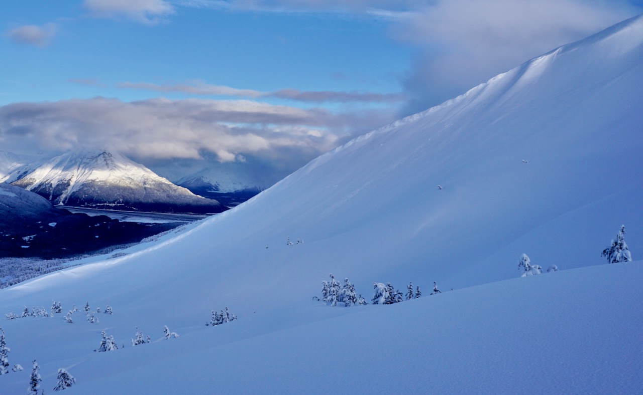
Lower Tincan Ridge. An example of where wind slabs and cornice falls could be found just below the Alpine zones and near the treeline. 1.13.21.

Additional Concern
  • Deep Persistent Slabs
    Deep Persistent Slabs
Deep Persistent Slabs
Deep Persistent Slab avalanches are the release of a thick cohesive layer of hard snow (a slab), when the bond breaks between the slab and an underlying persistent weak layer deep in the snowpack. The most common persistent weak layers involved in deep, persistent slabs are depth hoar or facets surrounding a deeply buried crust. Deep Persistent Slabs are typically hard to trigger, are very destructive and dangerous due to the large mass of snow involved, and can persist for months once developed. They are often triggered from areas where the snow is shallow and weak, and are particularly difficult to forecast for and manage.
More info at Avalanche.org

Under all the feet (5-7′) of new snow in the Girdwood and Turnagain zone, there is that old crust/facet combination from Dec 1st that we’ve been watching. It’s from elevations near 2,500′ and below. This layer keeps pointing to not being reactive and bore the weight of the past week’s onslaught of snow. All great news and with the layer being so deep, it’s unlikely a person can impact it and trigger an avalanche even if there was a mid-elevation slope where it was reactive. Possibly we can put this layer to bed soon for the Turnagain and Girdwood areas.

In Summit Lake, much less storm snow fell and the Dec 1 crust/facet combo is only a few feet below the surface. With observers finding varied reactivity with tests, data is pointing to an unlikely chance a person could trigger an avalanche on this layer in this area. Again good news. However, with another load or wind event, shallower zones could become concerning again.

One of my favorite photos of the year so far. What a winter! Aleph Johnston-Bloom stands in a 10′ snow pit on Tincan dug by one of CNFAIC’s all-star observers and checks out the various old buried layers. 1.13.21.

Weather
Fri, January 15th, 2021

Yesterday: Light to moderate snowfall was over the region. Around 5″ of new snow fell at Turnagain Pass, 2-3″ in the upper Girdwood Valley and only an inch or so in Summit Lake. Ridgetop winds were easterly and ramped up into the 30’s with gusts to 61 mph in the early part of the day before quieting down overnight. Temperatures climbed to 40F at sea level and 30F at mid elevations before cooling off overnight to near 32 at sea level and the low 20’sF along ridgetops.

Today: A band of snow showers has pushed in from the Gulf this morning and expected to add 2-3″ of snow from 1,000′ and above by this afternoon. The rain/snow line looks to climb up to 700-800 ft today, but all snow should fall at Turnagain Pass. Ridgetop winds are forecast to remain easterly in the 15-20mph range before picking up tonight ahead of the next storm front. Temperatures will climb into the mid 30’s at sea level while ridgetops remain close to the mid 20’sF.

Tomorrow: “Warmer air moving in with the next storm system Saturday will raise snow levels above pass level.” A remark in the NWS Recreation Forecast this morning. We can expect winds to be on the rise from the east, snowfall to increase and temperatures to climb tomorrow. This system should be short lived and exit Saturday night before what appears to be a more potent storm headed in for Sunday and into Monday.

PRECIPITATION 24-hour data (6am – 6am)

Temp Avg (F) Snow (in) Water (in) Snow Depth (in)
Center Ridge (1880′) 29 5 0.5 126
Summit Lake (1400′) 28 1 0.1 41
Alyeska Mid (1700′) 29 3 0.3 115

RIDGETOP 24-hour data (6am – 6am)

Temp Avg (F) Wind Dir Wind Avg (mph) Wind Gust (mph)
Sunburst (3812′) 21 NE 22 61
Seattle Ridge (2400′) 24 E* 7* 19*

*Data from 6am to 10pm. After this anemometer is rimed up again.

Observations
Recent Observations for Turnagain Pass
Date Region Location
03/27/24 Turnagain Observation: Tincan Trees
03/26/24 Turnagain Observation: Cornbiscuit
03/25/24 Turnagain Observation: Tincan
03/22/24 Turnagain Avalanche: Magnum Northwest Aspect
03/21/24 Turnagain Observation: Sunburst
03/21/24 Turnagain Observation: Tincan Proper North Aspect
03/20/24 Turnagain Avalanche: Seattle Creek Drainage
03/19/24 Turnagain Observation: Tincan CFR
03/18/24 Turnagain Avalanche: Tincan – Eddies – Seattle Ridge
03/18/24 Turnagain Observation: Tincan
Riding Areas

The riding areas page has moved. Please click here & update your bookmarks.


Subscribe to Turnagain Pass
Avalanche Forecast by Email

This is a general backcountry avalanche advisory issued for Turnagain Arm with Turnagain Pass as the core advisory area. This advisory does not apply to highways, railroads or operating ski areas.