Turnagain Pass RSS

Archives
ARCHIVED - Forecasts expire after 24 hours.
Issued
Thu, January 14th, 2021 - 7:00AM
Expires
Fri, January 15th, 2021 - 7:00AM
Forecaster
Aleph Johnston-Bloom
Avalanche risk The Bottom Line

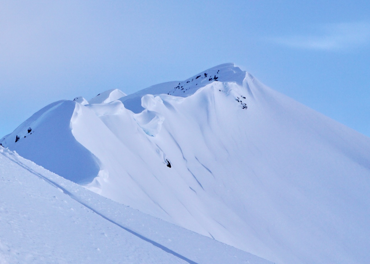
The avalanche danger is CONSIDERABLE above 1000′. Recent storm snow, combined with snow falling and increased winds today will be enough to create fresh wind slabs, 1-3′ deep. Due to the active loading natural avalanches will be possible and human triggered wind slabs are likely. In addition, there is still a chance of triggering a large avalanche that breaks in a deeper storm layer. Cautious route-finding and conservative decision-making are essential. Give cornices a wide berth and look for signs of instability.

The avalanche danger is MODERATE below 1,000′. Human triggered storm slab avalanches are possible above the rain line.

The National Weather Service has issued a Winter Weather Advisory for Portage Valley through Turnagain Pass.

Special Announcements
  • Heading to Hatcher Pass? Don’t forget to check the Thursday Conditions Summary at hpavalanche.org.
  • Forecaster chat #3– Saturday, Jan 16. Join CNFAIC forecasters Andrew Schauer and Wendy Wagner, along with special guest Karl Birkeland from the National Avalanche Center, as we talk about how we put together a forecast, and how we put an advisory to use while we are in the mountains.
Thu, January 14th, 2021
Alpine
Above 2,500'
3 - Considerable
Avalanche risk
Treeline
1,000'-2,500'
3 - Considerable
Avalanche risk
Below Treeline
Below 1,000'
2 - Moderate
Avalanche risk
0 - No Rating
1 - Low
2 - Moderate
3 - Considerable
4 - High
5 - Extreme
Avalanche risk Avalanche risk Avalanche risk Avalanche risk Avalanche risk
Travel Advice Generally safe avalanche conditions. Watch for unstable snow on isolated terrain features. Heightened avalanche conditions on specific terrain features. Evaluate snow and terrain carefully; identify features of concern. Dangerous avalanche conditions. Careful snowpack evaluation, cautious route-finding, and conservative decision-making essential. Very dangerous avalanche conditions. Travel in avalanche terrain not recommended. Extraordinarily dangerous avalanche conditions. Avoid all avalanche terrain.
Likelihood of Avalanches Natural and human-triggered avalanches unlikely. Natural avalanches unlikely; human-triggered avalanches possible. Natural avalanches possible; human-triggered avalanches likely. Natural avalanches likely; human-triggered avalanches very likely. Natural and human-triggered avalanches certain.
Avalanche Size and Distribution Small avalanches in isolated areas or extreme terrain. Small avalanches in specific areas; or large avalanches in isolated areas. Small avalanches in many areas; or large avalanches in specific areas; or very large avalanches in isolated areas. Large avalanches in many areas; or very large avalanches in specific areas. Very large avalanches in many areas.
Recent Avalanches

Observers yesterday were able to see more of the avalanche activity from the week long storm. There was evidence of a widespread avalanche cycle from Girdwood to the Hope Y.  Some crowns from avalanches earlier in the storm were harder to see and almost covered up by subsequent snowfall and some were distinct and more recent looking. The size of avalanches varied from large destructive slides to smaller pockets.  A few recent cornice falls were also observed. Of note, observers in Summit did not see slab avalanche activity in that area. They did mention a cornice fall in the Incredibowls and a couple of small loose snow avalanches.

Large avalanche on the southwest slope where Skookum meets Placer, 1.13.21. 

Slab on southwest slope of Tincan below the uptrack to Common Bowl almost filled in with snow. 1.13.21

Avalanche Problem 1
  • Wind Slabs
    Wind Slabs
  • Certain
    Very Likely
    Likely
    Possible
    Unlikely
    Likelihood
  • Historic (D4-5)
    Very Large (D3)
    Large (D2)
    Small (D1)
    Size
Wind Slabs
Wind Slab avalanches are the release of a cohesive layer of snow (a slab) formed by the wind. Wind typically transports snow from the upwind sides of terrain features and deposits snow on the downwind side. Wind slabs are often smooth and rounded and sometimes sound hollow, and can range from soft to hard. Wind slabs that form over a persistent weak layer (surface hoar, depth hoar, or near-surface facets) may be termed Persistent Slabs or may develop into Persistent Slabs.

Likelihood of Avalanches
Terms such as "unlikely", "likely", and "certain" are used to define the scale, with the chance of triggering or observing avalanches increasing as we move up the scale. For our purposes, "Unlikely" means that few avalanches could be triggered in avalanche terrain and natural avalanches are not expected. "Certain" means that humans will be able to trigger avalanches on many slopes, and natural avalanches are expected.

Size of Avalanches
Avalanche size is defined by the largest potential avalanche, or expected range of sizes related to the problem in question. Assigned size is a qualitative estimate based on the destructive classification system and requires specialists to estimate the harm avalanches may cause to hypothetical objects located in the avalanche track (AAA 2016, CAA 2014). Under this schema, "Small" avalanches are not large enough to bury humans and are relatively harmless unless they carry people over cliffs or through trees or rocks. Moving up the scale, avalanches become "Large" enough to bury, injure, or kill people. "Very Large" avalanches may bury or destroy vehicles or houses, and "Historic" avalanches are massive events capable of altering the landscape.

Signal Word Size (D scale) Simple Descriptor
Small 1 Unlikely to bury a person
Large 2 Can bury a person
Very Large 3 Can destroy a house
Historic 4 & 5 Can destroy part or all of a village
More info at Avalanche.org

Today east winds are forecast to be elevated throughout most of day, blowing 15-35 mph with gusts into the 40s and 50s. There is plenty of soft snow available for transport and an additional 3-6″ forecast to fall during the day. This is a perfect recipe for wind slabs. Be careful around terrain where wind slabs typically form– near ridgetops, below rollovers, and in cross-loaded gullies. Pay attention to changing surface conditions and the snow becoming stiffer. Because of the active loading natural avalanches will be possible and being aware of what terrain is above you will be key as well. Watch out for cracks shooting out from your snowmachine, skis or board.

Storms slabs: Decent visibility yesterday afternoon allowed for a better inventory of natural avalanche activity from the storm. There was a widespread avalanche cycle across the forecast area with a number of large avalanches with deep crowns. Signs are pointing to the snowpack stabilizing after this storm but there is still a chance of triggering a slab that breaks deeper into the storm snow. This is another reason for careful travel today.

Cornices: Cornices have grown large and are looming over some terrain. Wind-loading today could tip the balance and cause a cornice fall. Limit time spent underneath and give cornices a wide berth along ridgelines as they often break farther back that expected. A cornice fall today could also trigger an avalanche on the slope below.

Wind transport along Tincan ridge, 1.13.21. Look for blowing snow and active loading today.

Wind effect and cross-loading on Seattle Ridge, 1.13.21. This is a good example of terrain that might develop wind slabs today.

Hippy Bowl cornice, 1.13.21. Part of the cornice fell and triggered a small avalanche in the bowl. Cornices may fall today with additional loading and/or be easily triggered if you get too close.

Additional Concern
  • Deep Persistent Slabs
    Deep Persistent Slabs
Deep Persistent Slabs
Deep Persistent Slab avalanches are the release of a thick cohesive layer of hard snow (a slab), when the bond breaks between the slab and an underlying persistent weak layer deep in the snowpack. The most common persistent weak layers involved in deep, persistent slabs are depth hoar or facets surrounding a deeply buried crust. Deep Persistent Slabs are typically hard to trigger, are very destructive and dangerous due to the large mass of snow involved, and can persist for months once developed. They are often triggered from areas where the snow is shallow and weak, and are particularly difficult to forecast for and manage.
More info at Avalanche.org

We have been tracking a layer of faceted snow associated with the 12/1 rain crust, which is now buried around 6-8’ deep, and exists at elevations up to around 2500’. We have not been able to confirm if any of the recent large natural avalanches released at this layer but the vast majority appear to be storm snow only. It is unlikely a person could trigger an avalanche on this layer at the depths it is buried from Girdwood through Turnagain Pass.

The snowpack is shallower in Summit Lake and observers are finding varied reactivity with tests on this layer. However, at this point data is trending towards triggering an avalanche breaking on this layer to be unlikely here as well.  It may get a larger load and become more concerning. We will continue to keep tabs on this crust and any facet development in this area south of our forecast zone.

Weather
Thu, January 14th, 2021

Yesterday: Skies started out mostly cloudy with snow and rain showers (to around 300′) in the morning. By mid-day skies became partly cloudy. Winds were easterly 10-20 mph with gusts into the 30s. Temperatures were in the 20°Fs at ridgetops and 30°Fs at sea level. Skies became mostly cloudy overnight with light precipitation starting in the early morning. Easterly winds bumped up a bit with gusts into the 40s.

Today: Skies will be cloudy with snow and rain showers (rain/snowline around 400′) and 3-6″ (0.3 SWE) of snow in the forecast. Winds will be easterly 15-35 mph with gusts into the 40s and 50s. Temperatures will be in the 20°Fs at upper elevations and 30°Fs at sea level. Rain and snow continue tonight and may be heavy at times, 4-8″ (0.4 SWE) possible. Winds remain elevated and temperatures cool slightly.

Tomorrow: Rain and snow showers continue with light southerly winds and temperatures slowly rising. A warm wet storm is expected to move into the region overnight into Saturday. Expect a warm and stormy weekend. Think cold thoughts…

PRECIPITATION 24-hour data (6am – 6am)

Temp Avg (F) Snow (in) Water (in) Snow Depth (in)
Center Ridge (1880′) 30 2 0.1 125
Summit Lake (1400′) 24 0 0 39
Alyeska Mid (1700′) 29 2 0.2 115

RIDGETOP 24-hour data (6am – 6am)

Temp Avg (F) Wind Dir Wind Avg (mph) Wind Gust (mph)
Sunburst (3812′) 20 NE 13 39
Seattle Ridge (2400′) 24 E* 6* 18*

*Seattle Ridge data from 3 pm – 6 am. Big thanks to the rime clearing crew!

Observations
Recent Observations for Turnagain Pass
Date Region Location
04/23/24 Turnagain Observation: Turnagain Sunny Side
04/21/24 Turnagain Observation: Bertha Creek
04/20/24 Turnagain Avalanche: Spokane Creek
04/16/24 Turnagain Observation: Cornbiscuit
04/15/24 Turnagain Observation: Taylor Pass
04/15/24 Turnagain Observation: Seward Highway – Tern Lake to Portage
04/14/24 Turnagain Observation: Sunburst
04/14/24 Turnagain Observation: Turnagain Pass Snomo
04/13/24 Turnagain Observation: Spokane Creek
04/11/24 Turnagain Observation: Tincan
Riding Areas

The riding areas page has moved. Please click here & update your bookmarks.


Subscribe to Turnagain Pass
Avalanche Forecast by Email

This is a general backcountry avalanche advisory issued for Turnagain Arm with Turnagain Pass as the core advisory area. This advisory does not apply to highways, railroads or operating ski areas.