Turnagain Pass Avalanche Forecast RSS

Archives
ARCHIVED FORECAST - All forecasts expire after 24 hours from the posting date/time.
Issued
Wed, January 13th, 2021 - 7:00AM
Expires
Thu, January 14th, 2021 - 7:00AM
Forecaster
Aleph Johnston-Bloom
Avalanche risk The Bottom Line

The avalanche danger is CONSIDERABLE for all elevations. After a week of snow resulting in 6-10′ at mid and upper elevations, a rain/snow mix below 1100′ and sustained ridgetop winds, the mountains need time to adjust to the load. Today large, human triggered storm slab avalanches are likely on slopes over 30° and natural avalanches are possible. Cautious route-finding and conservative decision-making are essential. Give cornices a wide berth and look for signs of instability.

Snug Harbor/Lost Lake/ Seward:  These areas are out of our forecast zone but have also received large amounts of snow and caution is advised.

Special Announcements

Forecaster chat #3– Saturday, Jan 16. Join CNFAIC forecasters Andrew Schauer and Wendy Wagner, along with special guest Karl Birkeland from the National Avalanche Center, as we talk about how we put together a forecast, and how we put an advisory to use while we are in the mountains.

Thanks to our sponsors!
Wed, January 13th, 2021
Alpine
Above 2,500'
Considerable (3)
Avalanche risk
Treeline
1,000'-2,500'
Considerable (3)
Avalanche risk
Below Treeline
Below 1,000'
Considerable (3)
Avalanche risk
Alpine
Above 2,500'
Avalanche risk
Considerable (3)
Treeline
1,000'-2,500'
Avalanche risk
Considerable (3)
Below Treeline
Below 1,000'
Avalanche risk
Considerable (3)
Danger Scale:
No Rating (0)
Low (1)
Moderate (2)
Considerable (3)
High (4)
Extreme (5)
Recent Avalanches

With a break in the precipitation yesterday afternoon, there was an opportunity to see some of the avalanche activity from the storm. Evidence of large natural avalanches was observed across the forecast zone.  A few notable slides listed below:

  • Seattle Ridge: one above Bertha campground and one just south of the moto lot.
  • The south end of the west face of Magnum stopping before the power lines
  • A 10′ crown on a lower slope of Twin Peaks.

Avalanche on Seattle Ridge observed from the moto lot. 1.11.21.


Avalanche Problem 1
  • Storm Slabs
    Storm Slabs
  • Almost Certain
    Very Likely
    Likely
    Possible
    Unlikely
    Likelihood
  • Historic (D4-5)
    Very Large (D3)
    Large (D2)
    Small (D1)
    Size
Storm Slabs
Storm Slab avalanches are the release of a cohesive layer (a slab) of new snow that breaks within new snow or on the old snow surface. Storm-slabs typically last between a few hours and few days (following snowfall). Storm-slabs that form over a persistent weak layer (surface hoar, depth hoar, or near-surface facets) may be termed Persistent Slabs or may develop into Persistent Slabs.

Likelihood of Avalanches
Terms such as "unlikely", "likely", and "certain" are used to define the scale, with the chance of triggering or observing avalanches increasing as we move up the scale. For our purposes, "Unlikely" means that few avalanches could be triggered in avalanche terrain and natural avalanches are not expected. "Certain" means that humans will be able to trigger avalanches on many slopes, and natural avalanches are expected.

Size of Avalanches
Avalanche size is defined by the largest potential avalanche, or expected range of sizes related to the problem in question. Assigned size is a qualitative estimate based on the destructive classification system and requires specialists to estimate the harm avalanches may cause to hypothetical objects located in the avalanche track (AAA 2016, CAA 2014). Under this schema, "Small" avalanches are not large enough to bury humans and are relatively harmless unless they carry people over cliffs or through trees or rocks. Moving up the scale, avalanches become "Large" enough to bury, injure, or kill people. "Very Large" avalanches may bury or destroy vehicles or houses, and "Historic" avalanches are massive events capable of altering the landscape.

Signal Word Size (D scale) Simple Descriptor
Small 1 Unlikely to bury a person
Large 2 Can bury a person
Very Large 3 Can destroy a house
Historic 4 & 5 Can destroy part or all of a village
More info at Avalanche.org

We finally have a quick break in the onslaught of heavy precipitation before the next storm starts early tomorrow morning. There is SO much new snow (6-10′) which is incredibly appealing but still potentially very dangerous. It’s a day to carefully evaluate terrain and consequences if a large avalanche does release.  Low angle slopes without steep slopes above are great ways to enjoy the new snow without worry. As the snow settles it may become easier to travel but may also mean the slab is becoming more consolidated and may still be sensitive to human triggers. The old snow surface before all the snow fell had a thin layer of weak snow. In addition, there were a few temperature fluctuations throughout the storm cycle that could have also created weak interfaces. There have been large natural and explosive triggered avalanches during the storm with crowns ranging from 2-15′ deep. These are not the type of avalanches you want to mess with. We are hopeful that the new snow will eventually bond well and that we can enjoy it. However, we need more data after the storm and the snowpack needs more time to stabilize. As said many times before the snowpack is guilty until proven innocent and it is still likely that a person could trigger an unsurvivable avalanche today. We are in the 48 hour window after a storm where this is most common.

Signs of instability to watch for today:
–  Recent avalanches
–  Whumpfing (collapsing) of the snowpack, sure sign to avoid avalanche terrain period.
–  Shooting cracks, likely to be seen near ridgelines and on slopes where the wind has formed wind slabs.

Avoid travel on or under cornices as they may be quite tender today and often break farther back than expected.

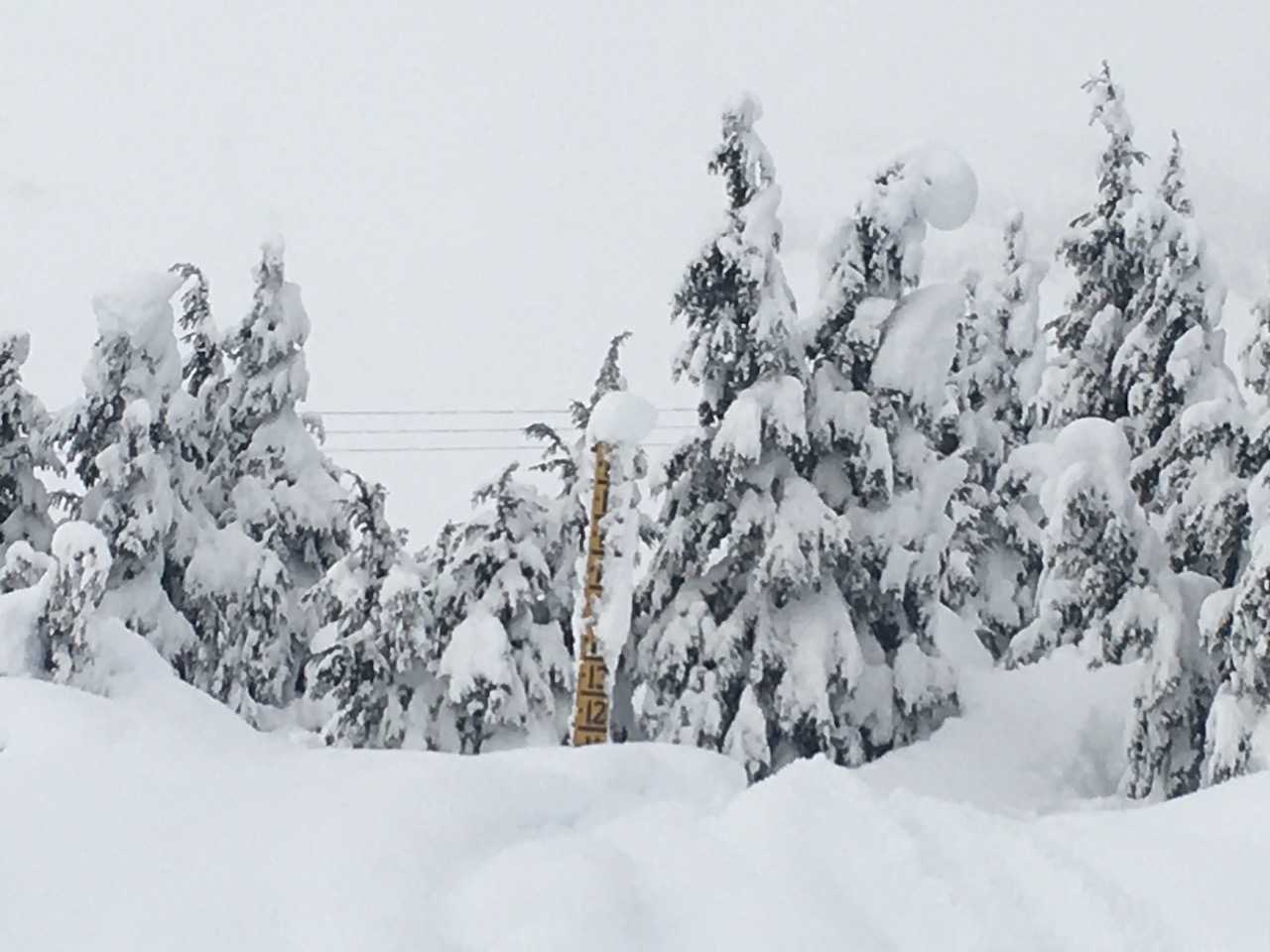
Turnagain Pass DOT snow stake, 1.12.21. The mountains have received a huge snow load in the past week. Please be patient and let the snowpack adjust.

Another view of the avalanche shown above in recent avalanches. Note the deep crown on the looker’s left. Seattle Ridge, 1.12.21.

Avalanche Problem 2
  • Deep Persistent Slabs
    Deep Persistent Slabs
  • Almost Certain
    Very Likely
    Likely
    Possible
    Unlikely
    Likelihood
  • Historic (D4-5)
    Very Large (D3)
    Large (D2)
    Small (D1)
    Size
Deep Persistent Slabs
Deep Persistent Slab avalanches are the release of a thick cohesive layer of hard snow (a slab), when the bond breaks between the slab and an underlying persistent weak layer deep in the snowpack. The most common persistent weak layers involved in deep, persistent slabs are depth hoar or facets surrounding a deeply buried crust. Deep Persistent Slabs are typically hard to trigger, are very destructive and dangerous due to the large mass of snow involved, and can persist for months once developed. They are often triggered from areas where the snow is shallow and weak, and are particularly difficult to forecast for and manage.

Likelihood of Avalanches
Terms such as "unlikely", "likely", and "certain" are used to define the scale, with the chance of triggering or observing avalanches increasing as we move up the scale. For our purposes, "Unlikely" means that few avalanches could be triggered in avalanche terrain and natural avalanches are not expected. "Certain" means that humans will be able to trigger avalanches on many slopes, and natural avalanches are expected.

Size of Avalanches
Avalanche size is defined by the largest potential avalanche, or expected range of sizes related to the problem in question. Assigned size is a qualitative estimate based on the destructive classification system and requires specialists to estimate the harm avalanches may cause to hypothetical objects located in the avalanche track (AAA 2016, CAA 2014). Under this schema, "Small" avalanches are not large enough to bury humans and are relatively harmless unless they carry people over cliffs or through trees or rocks. Moving up the scale, avalanches become "Large" enough to bury, injure, or kill people. "Very Large" avalanches may bury or destroy vehicles or houses, and "Historic" avalanches are massive events capable of altering the landscape.

Signal Word Size (D scale) Simple Descriptor
Small 1 Unlikely to bury a person
Large 2 Can bury a person
Very Large 3 Can destroy a house
Historic 4 & 5 Can destroy part or all of a village
More info at Avalanche.org

There is another tricky element to this avalanche puzzle. We have been tracking a layer of faceted snow associated with the 12/1 rain crust, which is now buried around 8’ deep, and exists at elevations up to around 2500’. We are not sure if any of the large natural avalanches released at this layer. The majority seemed to be storm snow only but the 10′ crown on lower Twin Peaks is suspect. This end of the Pass gets less snow and a lower elevation crown fits into the elevation band where we have found this crust facet/combo. It is unlikely a person could trigger an avalanche on this weak layer at the depths it is buried in Turnagain Pass. However, as we head south towards Summit Lake the storm totals taper dramatically and this could be possible. This is another unknown that needs more data after this storm cycle.

Weather
Wed, January 13th, 2021

Yesterday: Skies were mostly cloudy in the morning with snow showers and became partly cloudy in the afternoon. Winds were easterly 5-15 mph with gusts into the 20s. Temperatures were in the mid 30°s at sea level and high teens to low 20°Fs at ridgetops during the day and overnight. Skies became mostly cloudy again overnight and easterly winds increased t0 10-20 mph with gusts into the 30s.

Today: Mostly cloudy skies with snow showers, potentially becoming partly cloudy again in the afternoon. Easterly winds 10-20 mph with gusts into the 30s and 40s decreasing in the afternoon. Temperatures in the 30°Fs at sea level and mid t0 high 20°Fs at ridgetops. Overnight snow showers with easterly winds 5-15 mph increasing early Thursday morning. Temperatures in the mid 30°Fs at sea level and mid 20°Fs at ridgetops.

Tomorrow: There is Winter Storm Watch from Thursday morning through Thursday afternoon for Portage Valley and Turnagain Pass. Blizzard conditions possible. Total snow accumulations of 6-10″possible with up to 15″ through the Pass. East winds 15-25 mph with gusts into the 40s. Temperatures in the high to mid 30°Fs at sea level and the mid 20°Fs at ridgetops.

PRECIPITATION 24-hour data (6am – 6am)

Temp Avg (F) Snow (in) Water (in) Snow Depth (in)
Center Ridge (1880′) 29 3 0.4 129
Summit Lake (1400′) 25 1 0.2 24
Alyeska Mid (1700′) 29 3 0.4 119

RIDGETOP 24-hour data (6am – 6am)

Temp Avg (F) Wind Dir Wind Avg (mph) Wind Gust (mph)
Sunburst (3812′) 20 NE 13 39
Seattle Ridge (2400′) 25 N/A* N/A* N/A*

*Seattle Ridge anemometer is rimed over.

Observations
Recent Observations for Turnagain Pass
Date Region Location
05/22/23 Turnagain Avalanche: Tincan
05/12/23 Turnagain Avalanche: Tincan, Sunburst, Magnum, Cornbiscuit
05/07/23 Turnagain Observation: Tincan – Bear Tracks
05/05/23 Turnagain Observation: Seattle Ridge
05/02/23 Turnagain Observation: Cornbiscuit
05/02/23 Turnagain Observation: Seward Hwy Turnagain Pass
04/30/23 Turnagain Observation: Magnum
04/29/23 Turnagain Observation: Tincan
04/28/23 Turnagain Avalanche: Taylor Pass/Pastoral
04/28/23 Turnagain Avalanche: Tincan
Riding Areas
Updated Mon, May 15th, 2023

Status of riding areas across the Chugach NF is managed by the Glacier and Seward Ranger Districts, not avalanche center staff. Riding area information is posted as a public service to our users and updated based on snow depth and snow density to prevent resource damage at trailhead locations. Riding area questions contact: mailroom_r10_chugach@fs.fed.us

Area Status Weather & Riding Conditions
Glacier District
Johnson Pass
Closed
Closed May 15.
Placer River
Closed
Closed May 15.
Skookum Drainage
Closed
Will close to motorized use on April 1, 2023 per the National Forest Plan.
Turnagain Pass
Open
Chugach NF staff will be assessing daily after May 15th. Please keep machines on the snow and avoid brown spots to keep this area open as long as possible.
Twentymile
Closed
Scheduled closure May 1.
Seward District
Carter Lake
Closed
Scheduled closure May 1.
Lost Lake Trail
Closed
Scheduled closure May 1.
Primrose Trail
Closed
Scheduled closure May 1.
Resurrection Pass Trail
Closed
Closed to motorized use for the 2022/23 winter season per Forest Plan. Open next season.
Snug Harbor
Closed
Extended opening until May 15.
South Fork Snow River Corridor
Closed
Scheduled closure May 1.
Summit Lake
Closed
Scheduled closure May 1.

Subscribe to Turnagain Pass
Avalanche Forecast by Email

This is a general backcountry avalanche advisory issued for Turnagain Arm with Turnagain Pass as the core advisory area. This advisory does not apply to highways, railroads or operating ski areas.