Turnagain Pass RSS

Archives
ARCHIVED - Forecasts expire after 24 hours.
Issued
Mon, January 11th, 2021 - 7:00AM
Expires
Tue, January 12th, 2021 - 7:00AM
Forecaster
Aleph Johnston-Bloom
Avalanche Warning
Issued: January 11, 2021 6:00 am
Travel in avalanche terrain is not recommended. Avoid being on or beneath all steep slopes.
Avalanche risk The Bottom Line

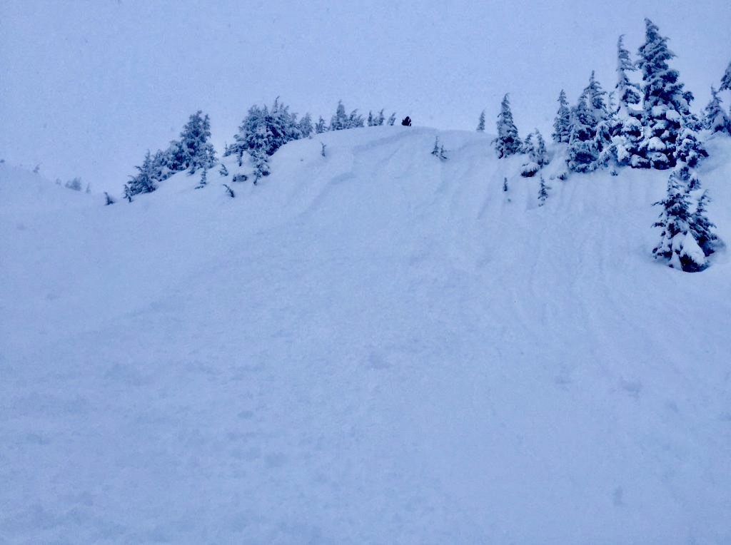
We have extended the Backcountry Avalanche Warning through the National Weather Service today.  With heavy snowfall, rain, and strong winds the avalanche danger remains HIGH in the mountains surrounding Turnagain Pass, Girdwood Valley, Portage Valley, and areas on the Kenai including Summit Lake and the Seward/Lost Lake zone. Dangerous avalanche conditions are expected on all slopes 30° and steeper – including runout zones. Large avalanches are expected to release naturally, be easily triggered by people and send debris to valley floors. Travel in and below avalanche terrain is NOT recommended. Areas with steep slopes above should be avoided, such as the Byron Glacier Trail and the Seattle Ridge Uptrack. Even small terrain features could act as deadly terrain traps.

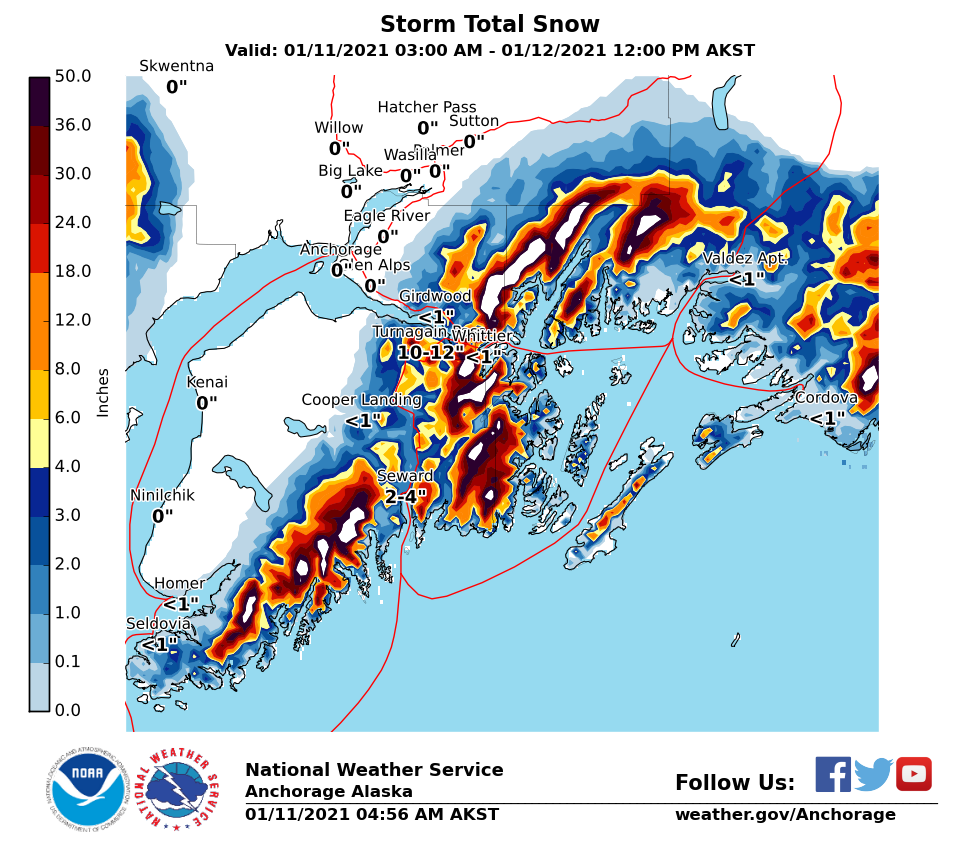
The National Weather Service has issued a Special Weather Statement with this storm.

Special Announcements
  • From the Alaska Department of Transportation: There will be intermittent traffic delays Monday, January 11, 2021 on the Seward Highway for Avalanche Hazard Reduction work. From mileposts 90 to 100 on the Seward Highway, between Girdwood and Bird. Motorists should expect delays of up to 45 minutes between 11:00 AM and 4:00 PM. Updates will be posted on the 511 system. http://511.alaska.gov/
  • Forecaster chat #3 will be Saturday, Jan 16 from 6:00-7:30 p.m. Join CNFAIC forecasters Andrew Schauer and Wendy Wagner, along with special guest Karl Birkeland from the National Avalanche Center, as we talk about how we put together an avalanche forecast, and how we put the forecast to use while we are in the mountains.
Mon, January 11th, 2021
Alpine
Above 2,500'
4 - High
Avalanche risk
Treeline
1,000'-2,500'
4 - High
Avalanche risk
Below Treeline
Below 1,000'
4 - High
Avalanche risk
0 - No Rating
1 - Low
2 - Moderate
3 - Considerable
4 - High
5 - Extreme
Avalanche risk Avalanche risk Avalanche risk Avalanche risk Avalanche risk
Travel Advice Generally safe avalanche conditions. Watch for unstable snow on isolated terrain features. Heightened avalanche conditions on specific terrain features. Evaluate snow and terrain carefully; identify features of concern. Dangerous avalanche conditions. Careful snowpack evaluation, cautious route-finding, and conservative decision-making essential. Very dangerous avalanche conditions. Travel in avalanche terrain not recommended. Extraordinarily dangerous avalanche conditions. Avoid all avalanche terrain.
Likelihood of Avalanches Natural and human-triggered avalanches unlikely. Natural avalanches unlikely; human-triggered avalanches possible. Natural avalanches possible; human-triggered avalanches likely. Natural avalanches likely; human-triggered avalanches very likely. Natural and human-triggered avalanches certain.
Avalanche Size and Distribution Small avalanches in isolated areas or extreme terrain. Small avalanches in specific areas; or large avalanches in isolated areas. Small avalanches in many areas; or large avalanches in specific areas; or very large avalanches in isolated areas. Large avalanches in many areas; or very large avalanches in specific areas. Very large avalanches in many areas.
Recent Avalanches

Crow Creek: Natural avalanches were observed in this area yesterday afternoon.

Click HERE for link to video. Thanks to George Creighton for sharing this.

Human triggered avalanches were reported on Notch Mountain in Girdwood and in the Tincan Trees.

Skier triggered storm slab in the Tincan Trees, crown was reported to be 12-16″ deep, 1.10.21. Photo: Anonymous.


Avalanche Problem 1
  • Storm Slabs
    Storm Slabs
  • Certain
    Very Likely
    Likely
    Possible
    Unlikely
    Likelihood
  • Historic (D4-5)
    Very Large (D3)
    Large (D2)
    Small (D1)
    Size
Storm Slabs
Storm Slab avalanches are the release of a cohesive layer (a slab) of new snow that breaks within new snow or on the old snow surface. Storm-slabs typically last between a few hours and few days (following snowfall). Storm-slabs that form over a persistent weak layer (surface hoar, depth hoar, or near-surface facets) may be termed Persistent Slabs or may develop into Persistent Slabs.

Likelihood of Avalanches
Terms such as "unlikely", "likely", and "certain" are used to define the scale, with the chance of triggering or observing avalanches increasing as we move up the scale. For our purposes, "Unlikely" means that few avalanches could be triggered in avalanche terrain and natural avalanches are not expected. "Certain" means that humans will be able to trigger avalanches on many slopes, and natural avalanches are expected.

Size of Avalanches
Avalanche size is defined by the largest potential avalanche, or expected range of sizes related to the problem in question. Assigned size is a qualitative estimate based on the destructive classification system and requires specialists to estimate the harm avalanches may cause to hypothetical objects located in the avalanche track (AAA 2016, CAA 2014). Under this schema, "Small" avalanches are not large enough to bury humans and are relatively harmless unless they carry people over cliffs or through trees or rocks. Moving up the scale, avalanches become "Large" enough to bury, injure, or kill people. "Very Large" avalanches may bury or destroy vehicles or houses, and "Historic" avalanches are massive events capable of altering the landscape.

Signal Word Size (D scale) Simple Descriptor
Small 1 Unlikely to bury a person
Large 2 Can bury a person
Very Large 3 Can destroy a house
Historic 4 & 5 Can destroy part or all of a village
More info at Avalanche.org

The mountains need plenty of time to adjust to all this snow. Please be patient! We really can not stress enough that travel in and under avalanche terrain is not recommended today. With continued heavy snow, rain and wind-loading large natural avalanches are likely and may run to valley bottoms. Human triggered unsurvivable avalanches are very likely. Today is a great day to go to Alyeska or play in the flats well away from the slopes above or stay home and watch avalanche videos on YouTube!  In the last 24 hours 1-2.5′ of additional snow (2.0″ SWE) has fallen in the forecast area, with a rain/snow mix below 1200′.

Storm totals (beginning Wednesday morning through 6 am today)

  • Turnagain Pass, at 1,880′:  6.4″of water equivalent, roughly 5-6′ of snow above treeline.
  • Girdwood Valley at 1,700′:  6.0″ of water equivalent, roughly 5-6′ of snow above treeline.
  • Summit Lake at 1,400′: 1″ of water equivalent, roughly 12-14″ of snow above treeline.

Those are pretty impressive snow totals with a lot of water weight. With all this precipitation there has been sustained easterly ridgetop winds, 15-35 mph with gusts into the 30s and 40s. Snow and rain continue today with rain/snow line forecast to rise again to 1000′. Winds will remain elevated. We saw both natural and human triggered avalanches yesterday and expect LARGE dangerous storm slab avalanches again today. All the new snow, rain and wind-loading are adding stress to the snowpack. Give it time to adjust!!!

Cornices: With several feet of sticky snow this week, and sustained strong winds, cornices are becoming quite large. These could fail today and trigger a large avalanche on the slope below.

Additional snow forecast to fall between this morning and tomorrow mid-day. 

Avalanche Problem 2
  • Deep Persistent Slabs
    Deep Persistent Slabs
  • Certain
    Very Likely
    Likely
    Possible
    Unlikely
    Likelihood
  • Historic (D4-5)
    Very Large (D3)
    Large (D2)
    Small (D1)
    Size
Deep Persistent Slabs
Deep Persistent Slab avalanches are the release of a thick cohesive layer of hard snow (a slab), when the bond breaks between the slab and an underlying persistent weak layer deep in the snowpack. The most common persistent weak layers involved in deep, persistent slabs are depth hoar or facets surrounding a deeply buried crust. Deep Persistent Slabs are typically hard to trigger, are very destructive and dangerous due to the large mass of snow involved, and can persist for months once developed. They are often triggered from areas where the snow is shallow and weak, and are particularly difficult to forecast for and manage.

Likelihood of Avalanches
Terms such as "unlikely", "likely", and "certain" are used to define the scale, with the chance of triggering or observing avalanches increasing as we move up the scale. For our purposes, "Unlikely" means that few avalanches could be triggered in avalanche terrain and natural avalanches are not expected. "Certain" means that humans will be able to trigger avalanches on many slopes, and natural avalanches are expected.

Size of Avalanches
Avalanche size is defined by the largest potential avalanche, or expected range of sizes related to the problem in question. Assigned size is a qualitative estimate based on the destructive classification system and requires specialists to estimate the harm avalanches may cause to hypothetical objects located in the avalanche track (AAA 2016, CAA 2014). Under this schema, "Small" avalanches are not large enough to bury humans and are relatively harmless unless they carry people over cliffs or through trees or rocks. Moving up the scale, avalanches become "Large" enough to bury, injure, or kill people. "Very Large" avalanches may bury or destroy vehicles or houses, and "Historic" avalanches are massive events capable of altering the landscape.

Signal Word Size (D scale) Simple Descriptor
Small 1 Unlikely to bury a person
Large 2 Can bury a person
Very Large 3 Can destroy a house
Historic 4 & 5 Can destroy part or all of a village
More info at Avalanche.org

We have been tracking a layer of faceted snow associated with the 12/1 rain crust, which is now buried 4-7’ deep, and exists at elevations up to around 2500’. While it has been a while since we have seen any avalanches fail on this layer, the current storm will be putting that weak snow to the test. There is chance we could see very large avalanches failing on this layer. This is yet another reason to avoid avalanche terrain today!

Weather
Mon, January 11th, 2021

Yesterday: Cloudy skies with snow and rain falling throughout the day. Rain/snow line fluctuated going as high as 1800′ in Girdwood valley and around 1100′ at Turnagain, then dropping back to sea level overnight, with around 2′ (2″ SWE) of new snow falling at upper elevations. Winds were easterly 15-35 mph with gusts into the 40s and 50s.

Today: Cloudy skies and continued precipitation which may be heavy at times. Rain/snow line is forecast to rise to 1000′ but may stay lower if the cold air pushing into the area sticks around. There was actually snow falling in Portage this morning. Another foot of snow (1.0 SWE)  is expected by tomorrow mid-day. East winds continue today and tonight, 15-35 mph with gusts into the 40s and 50s. Temperatures will be in the mid 20°Fs to mid 30°Fs. Precipitation continues overnight with slightly cooler temperatures.

Tomorrow: Snow and rain showers continue with precipitation easing off in the afternoon before the next storm moves in overnight. Winds will be easterly 5-10 mph with gusts into the 20s. Temperatures will be in the mid 30°Fs at sea level and mid 20°Fs at ridgetops.

PRECIPITATION 24-hour data (6am – 6am)

Temp Avg (F) Snow (in) Water (in) Snow Depth (in)
Center Ridge (1880′) 32 10 1.8 121
Summit Lake (1400′) 33 1 0.1 38
Alyeska Mid (1700′) 32 18 1.8 113

RIDGETOP 24-hour data (6am – 6am)

Temp Avg (F) Wind Dir Wind Avg (mph) Wind Gust (mph)
Sunburst (3812′) 23 NE 24 55
Seattle Ridge (2400′) 26 N/A* N/A* N/A*

*Seattle Ridge anemometer is rimed over.

Observations
Recent Observations for Turnagain Pass
Date Region Location
04/16/24 Turnagain Observation: Cornbiscuit
04/15/24 Turnagain Observation: Taylor Pass
04/15/24 Turnagain Observation: Seward Highway – Tern Lake to Portage
04/14/24 Turnagain Observation: Sunburst
04/14/24 Turnagain Observation: Turnagain Pass Snomo
04/13/24 Turnagain Observation: Spokane Creek
04/11/24 Turnagain Observation: Tincan
04/10/24 Turnagain Avalanche: Seattle Ridge
04/10/24 Turnagain Observation: Cornbiscuit South Face
04/10/24 Turnagain Avalanche: Tincan
Riding Areas

The riding areas page has moved. Please click here & update your bookmarks.


Subscribe to Turnagain Pass
Avalanche Forecast by Email

This is a general backcountry avalanche advisory issued for Turnagain Arm with Turnagain Pass as the core advisory area. This advisory does not apply to highways, railroads or operating ski areas.