Turnagain Pass RSS

Archives
ARCHIVED - Forecasts expire after 24 hours.
Issued
Sun, January 10th, 2021 - 7:00AM
Expires
Mon, January 11th, 2021 - 7:00AM
Forecaster
Andrew Schauer
Avalanche Warning
Issued: January 10, 2021 6:00 am
Travel in avalanche terrain is not recommended. Avoid being on or beneath all steep slopes.
Avalanche risk The Bottom Line

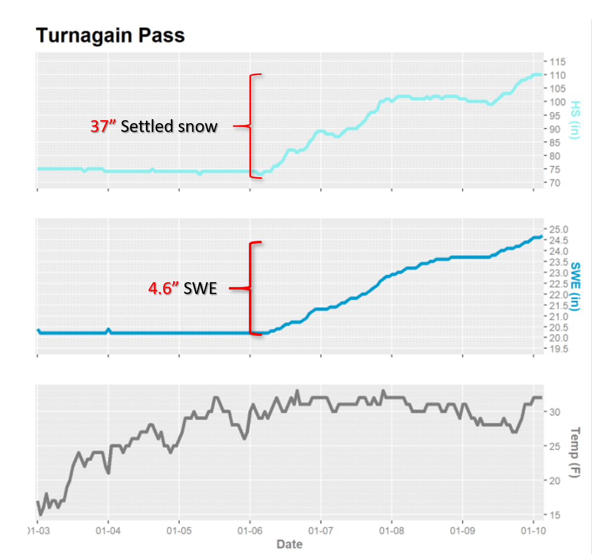
We have issued a Backcountry Avalanche Warning through the National Weather Service as heavy snowfall, strong winds, and rain on snow will elevate the avalanche danger to HIGH today. It is very likely a human could trigger an avalanche 3-5’ deep, and it is likely that we will see large natural avalanches as well. These avalanches may run into lower elevation runout zones in the valley bottoms. Travel in and below avalanche terrain is not recommended today.

Seward/Lost Lake: The mountains around Seward and Lost Lake have gotten over 3′ of heavy snow this week. With more snow expected today and the rain level creeping up, dangerous avalanche conditions exist in these areas.

Summer Hiking Trails: Avalanche danger exists on summer trails that pass through avalanche paths, such as they Byron Glacier Trail and many others.

The National Weather Service has issued a Special Weather Statement with this storm.

Special Announcements

Forecaster chat #3 will be Saturday, Jan 16 from 6:00-7:30 p.m. Join CNFAIC forecasters Andrew Schauer and Wendy Wagner, along with special guest Karl Birkeland from the National Avalanche Center, as we talk about how we put together a forecast, and how we put an advisory to use while we are in the mountains.

Sun, January 10th, 2021
Alpine
Above 2,500'
4 - High
Avalanche risk
Treeline
1,000'-2,500'
4 - High
Avalanche risk
Below Treeline
Below 1,000'
4 - High
Avalanche risk
0 - No Rating
1 - Low
2 - Moderate
3 - Considerable
4 - High
5 - Extreme
Avalanche risk Avalanche risk Avalanche risk Avalanche risk Avalanche risk
Travel Advice Generally safe avalanche conditions. Watch for unstable snow on isolated terrain features. Heightened avalanche conditions on specific terrain features. Evaluate snow and terrain carefully; identify features of concern. Dangerous avalanche conditions. Careful snowpack evaluation, cautious route-finding, and conservative decision-making essential. Very dangerous avalanche conditions. Travel in avalanche terrain not recommended. Extraordinarily dangerous avalanche conditions. Avoid all avalanche terrain.
Likelihood of Avalanches Natural and human-triggered avalanches unlikely. Natural avalanches unlikely; human-triggered avalanches possible. Natural avalanches possible; human-triggered avalanches likely. Natural avalanches likely; human-triggered avalanches very likely. Natural and human-triggered avalanches certain.
Avalanche Size and Distribution Small avalanches in isolated areas or extreme terrain. Small avalanches in specific areas; or large avalanches in isolated areas. Small avalanches in many areas; or large avalanches in specific areas; or very large avalanches in isolated areas. Large avalanches in many areas; or very large avalanches in specific areas. Very large avalanches in many areas.
Recent Avalanches

Girdwood Valley: Skiers triggered storm slab avalanches just over a foot deep on steep rollovers on Notch Mtn. yesterday.

Girdwood Valley: There was recent debris from a large cornice fall on Raggedtop. The cornice appeared to break sometime during the beginning of the 1/6 storm, and It was difficult to tell if the cornice triggered an avalanche in the new snow or not.

Seattle Ridge: Riders reported large shooting cracks on small test slopes in the Seattle Ridge flats, fracturing 2-3’ deep and propagating several snowmachine lengths outward.

Seward Highway: In the past few days, we have also noted debris from natural avalanches along the Seward Highway from Bird to Seward.

Avalanche Problem 1
  • Storm Slabs
    Storm Slabs
  • Aspect/Elevation
  • Certain
    Very Likely
    Likely
    Possible
    Unlikely
    Likelihood
  • Historic (D4-5)
    Very Large (D3)
    Large (D2)
    Small (D1)
    Size
Storm Slabs
Storm Slab avalanches are the release of a cohesive layer (a slab) of new snow that breaks within new snow or on the old snow surface. Storm-slabs typically last between a few hours and few days (following snowfall). Storm-slabs that form over a persistent weak layer (surface hoar, depth hoar, or near-surface facets) may be termed Persistent Slabs or may develop into Persistent Slabs.

Aspect/Elevation of the Avalanche Problem
Specialists develop a graphic representation of the potential distribution of a particular avalanche problem across the topography. This aspect/elevation rose is used to indicate where the particular avalanche problem is thought to exist on all elevation aspects. Areas where the avalanche problem is thought to exist are colored grey, and it is less likely to be encountered in areas colored white.

Likelihood of Avalanches
Terms such as "unlikely", "likely", and "certain" are used to define the scale, with the chance of triggering or observing avalanches increasing as we move up the scale. For our purposes, "Unlikely" means that few avalanches could be triggered in avalanche terrain and natural avalanches are not expected. "Certain" means that humans will be able to trigger avalanches on many slopes, and natural avalanches are expected.

Size of Avalanches
Avalanche size is defined by the largest potential avalanche, or expected range of sizes related to the problem in question. Assigned size is a qualitative estimate based on the destructive classification system and requires specialists to estimate the harm avalanches may cause to hypothetical objects located in the avalanche track (AAA 2016, CAA 2014). Under this schema, "Small" avalanches are not large enough to bury humans and are relatively harmless unless they carry people over cliffs or through trees or rocks. Moving up the scale, avalanches become "Large" enough to bury, injure, or kill people. "Very Large" avalanches may bury or destroy vehicles or houses, and "Historic" avalanches are massive events capable of altering the landscape.

Signal Word Size (D scale) Simple Descriptor
Small 1 Unlikely to bury a person
Large 2 Can bury a person
Very Large 3 Can destroy a house
Historic 4 & 5 Can destroy part or all of a village
More info at Avalanche.org

Today it is very likely a human could trigger an avalanche 4-6’ deep in the new snow from the past 4 days. With more snow on the way, and rain on snow expected up to 1600’, we are also likely to see some large natural avalanche activity today. Since yesterday morning, we have gotten close to a foot of new snow equaling around an inch of snow water equivalent (SWE) at Turnagain pass and Alyeska, with sustained easterly ridgetop winds of 20-35 mph and gusts to 57 mph. This is just the latest round of snow; we have seen steady precipitation since Wednesday morning bring the following storm totals as of 5:00 this morning:

3-4’ snow equaling 4.6” SWE at the Center Ridge snotel site.

3-4’ snow equaling 4.2” SWE at Alyeska’s Mid-mountain station.

11” snow equaling 0.9” SWE at the Summit Creek snotel site.

Snowfall during the day could bring another 6-10”, with rain levels rising to around 1600’. This active loading will make human-triggered avalanches very likely, and we are anticipating some large natural releases as well. The new/old interface is a mix of surface hoar, near-surface facets, low-density stellar dendrites, and very firm wind surfaces, and we have already seen avalanches propagating wide on these various layers. The snowpack will need time to adjust to this heavy load, and for now travel in avalanche terrain is not recommended. Avoid traveling on or below steep slopes, as we are expecting large avalanches to run far into lower-elevation runout zones today. With another round of heavy snowfall possible tonight, we are expecting to see elevated avalanche danger through tomorrow.

Cornices: With several feet of sticky snow this week, and sustained strong winds, cornices are becoming quite large. Some of these cornices have already failed naturally, and it is likely we will see similar activity as this storm continues.


The Turnagain Pass snotel station (el. 1880′) is showing 3-4′ of snow equaling 4.6″ SWE since Wednesday.

The NWS is predicting 3.3″ snow water equivalent between Saturday and Monday. We are about halfway through the forecast period, and right on track to hit that mark.

Avalanche Problem 2
  • Deep Persistent Slabs
    Deep Persistent Slabs
  • Aspect/Elevation
  • Certain
    Very Likely
    Likely
    Possible
    Unlikely
    Likelihood
  • Historic (D4-5)
    Very Large (D3)
    Large (D2)
    Small (D1)
    Size
Deep Persistent Slabs
Deep Persistent Slab avalanches are the release of a thick cohesive layer of hard snow (a slab), when the bond breaks between the slab and an underlying persistent weak layer deep in the snowpack. The most common persistent weak layers involved in deep, persistent slabs are depth hoar or facets surrounding a deeply buried crust. Deep Persistent Slabs are typically hard to trigger, are very destructive and dangerous due to the large mass of snow involved, and can persist for months once developed. They are often triggered from areas where the snow is shallow and weak, and are particularly difficult to forecast for and manage.

Aspect/Elevation of the Avalanche Problem
Specialists develop a graphic representation of the potential distribution of a particular avalanche problem across the topography. This aspect/elevation rose is used to indicate where the particular avalanche problem is thought to exist on all elevation aspects. Areas where the avalanche problem is thought to exist are colored grey, and it is less likely to be encountered in areas colored white.

Likelihood of Avalanches
Terms such as "unlikely", "likely", and "certain" are used to define the scale, with the chance of triggering or observing avalanches increasing as we move up the scale. For our purposes, "Unlikely" means that few avalanches could be triggered in avalanche terrain and natural avalanches are not expected. "Certain" means that humans will be able to trigger avalanches on many slopes, and natural avalanches are expected.

Size of Avalanches
Avalanche size is defined by the largest potential avalanche, or expected range of sizes related to the problem in question. Assigned size is a qualitative estimate based on the destructive classification system and requires specialists to estimate the harm avalanches may cause to hypothetical objects located in the avalanche track (AAA 2016, CAA 2014). Under this schema, "Small" avalanches are not large enough to bury humans and are relatively harmless unless they carry people over cliffs or through trees or rocks. Moving up the scale, avalanches become "Large" enough to bury, injure, or kill people. "Very Large" avalanches may bury or destroy vehicles or houses, and "Historic" avalanches are massive events capable of altering the landscape.

Signal Word Size (D scale) Simple Descriptor
Small 1 Unlikely to bury a person
Large 2 Can bury a person
Very Large 3 Can destroy a house
Historic 4 & 5 Can destroy part or all of a village
More info at Avalanche.org

We have been tracking a layer of faceted snow associated with the 12/1 rain crust, which is now buried 4-7’ deep, and exists at elevations up to around 2500’. While it has been a while since we have seen any avalanches fail on this layer, the current storm will be putting that weak snow to the test. There is a small chance we could see very large avalanches failing on this layer. While this will be an interesting test, it is of secondary concern today because of the high likelihood of large avalanches failing within the storm snow mentioned above.

Weather
Sun, January 10th, 2021

Yesterday: Turnagain pass got another 11” snow equaling 1” SWE, and Alyeska top station recorded 1.12” SWE. The rain level rose to around 1000’ overnight. Easterly ridgetop winds blew 20-35 mph at the Sunburst station, with gusts in the mid-50’s F. Temperatures reached the low 20’s F at upper elevations and the mid- 30’s F at low elevations.

Today: Snow showers will continue today, with another 6-10” possible during the day. Easterly ridgetop winds are expected around 25-35 mph, with gusts in the 40’s. High temperatures will be in the mid-20’s F at upper elevations and low 30’s F at lower elevations, with rain possible up to 1600’.

Tomorrow: Snowfall is expected to pick up again tonight, bringing close to a foot of new snow by tomorrow morning. The rain level is expected to drop back down to 1000’ overnight, with low temperatures in the mid- to upper 20’s F. Snow showers are expected to continue through the day tomorrow.

PRECIPITATION 24-hour data (6am – 6am)

Temp Avg (F) Snow (in) Water (in) Snow Depth (in)
Center Ridge (1880′) 30 11 1.0 110
Summit Lake (1400′) 29 1 0.1 37
Alyeska Mid (1700′) 30 7 0.9 103

RIDGETOP 24-hour data (6am – 6am)

Temp Avg (F) Wind Dir Wind Avg (mph) Wind Gust (mph)
Sunburst (3812′) 21 ENE 24 57
Seattle Ridge (2400′) 24 N/A* N/A* N/A*

*Seattle Ridge anemometer is rimed over.

Observations
Recent Observations for Turnagain Pass
Date Region Location
04/23/24 Turnagain Observation: Turnagain Sunny Side
04/21/24 Turnagain Observation: Bertha Creek
04/20/24 Turnagain Avalanche: Spokane Creek
04/16/24 Turnagain Observation: Cornbiscuit
04/15/24 Turnagain Observation: Taylor Pass
04/15/24 Turnagain Observation: Seward Highway – Tern Lake to Portage
04/14/24 Turnagain Observation: Sunburst
04/14/24 Turnagain Observation: Turnagain Pass Snomo
04/13/24 Turnagain Observation: Spokane Creek
04/11/24 Turnagain Observation: Tincan
Riding Areas

The riding areas page has moved. Please click here & update your bookmarks.


Subscribe to Turnagain Pass
Avalanche Forecast by Email

This is a general backcountry avalanche advisory issued for Turnagain Arm with Turnagain Pass as the core advisory area. This advisory does not apply to highways, railroads or operating ski areas.