Turnagain Pass RSS

Archives
ARCHIVED - Forecasts expire after 24 hours.
Issued
Thu, January 9th, 2020 - 7:00AM
Expires
Fri, January 10th, 2020 - 7:00AM
Forecaster
Aleph Johnston-Bloom
Avalanche risk The Bottom Line

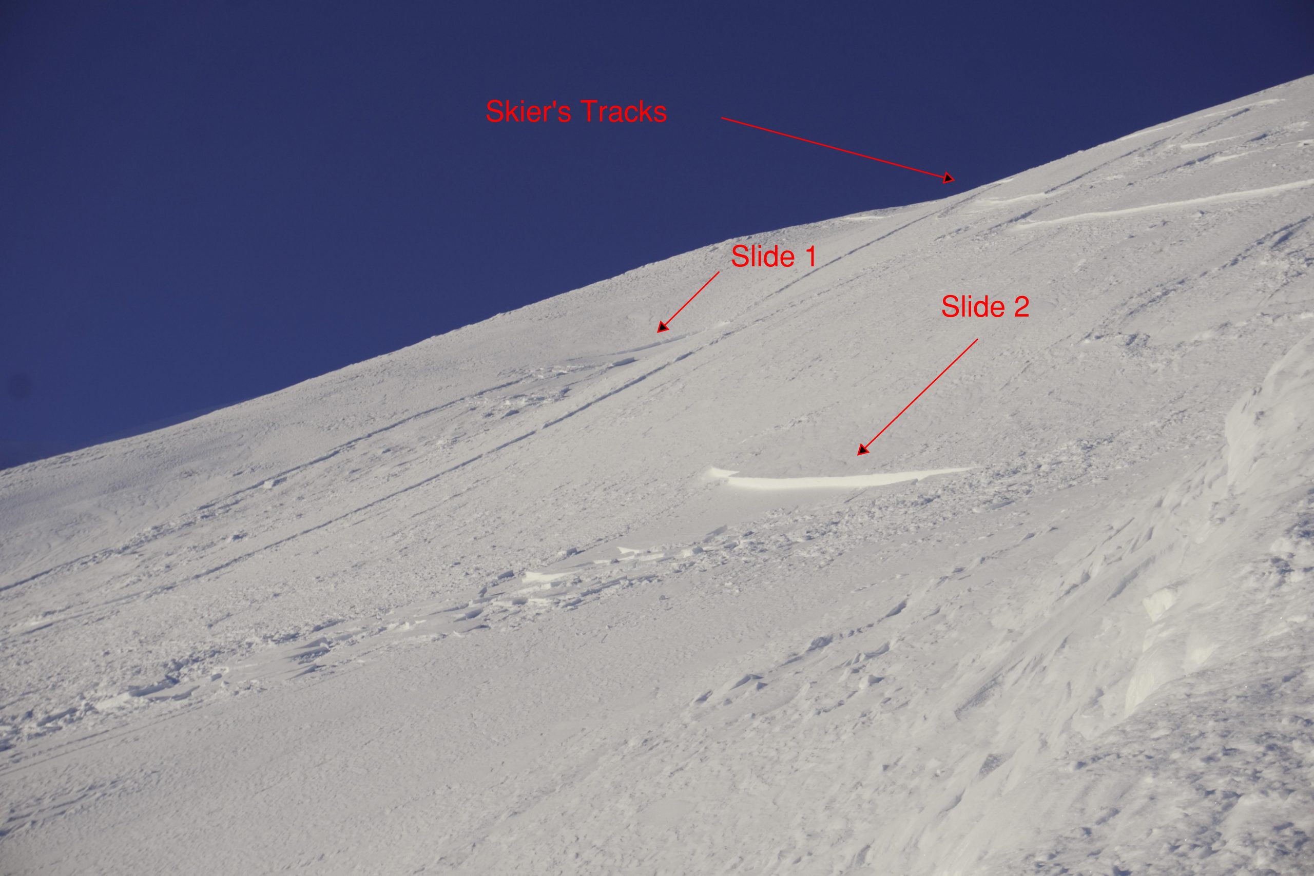
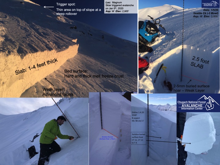
The avalanche danger remains MODERATE above 1000′. Triggering a large avalanche on a weak layer buried 1-3′ deep is possible. In addition, there is the potential to trigger a small wind slab in wind loaded terrain or a sluff on steep protected slopes. Give cornices a wide berth and limit exposure under glide cracks.

Special Announcements

Alaskans! Help us reach $20,000 in 2020 for Chugach Avy’s 20th anniversary next winter. Pick.Click.Give. some or all of your PFD to Friends of the Chugach National Forest Avalanche Info Center. Your donation pre-pays your annual membership AND guarantees good snow karma for winter 2020/21. Thanks, Friends!  Pick.Click.Give. link: for Friends of the CNFAIC

This Saturday:  The Hatcher Pass Avalanche Center and the Hatcher Pass Snow Riders Club are hosting a free avalanche workshop Saturday, Jan 11th at 11 am at the Gold Mint parking lot. Check out our events page for more information!


Thu, January 9th, 2020
Alpine
Above 2,500'
2 - Moderate
Avalanche risk
Treeline
1,000'-2,500'
2 - Moderate
Avalanche risk
Below Treeline
Below 1,000'
1 - Low
Avalanche risk
0 - No Rating
1 - Low
2 - Moderate
3 - Considerable
4 - High
5 - Extreme
Avalanche risk Avalanche risk Avalanche risk Avalanche risk Avalanche risk
Travel Advice Generally safe avalanche conditions. Watch for unstable snow on isolated terrain features. Heightened avalanche conditions on specific terrain features. Evaluate snow and terrain carefully; identify features of concern. Dangerous avalanche conditions. Careful snowpack evaluation, cautious route-finding, and conservative decision-making essential. Very dangerous avalanche conditions. Travel in avalanche terrain not recommended. Extraordinarily dangerous avalanche conditions. Avoid all avalanche terrain.
Likelihood of Avalanches Natural and human-triggered avalanches unlikely. Natural avalanches unlikely; human-triggered avalanches possible. Natural avalanches possible; human-triggered avalanches likely. Natural avalanches likely; human-triggered avalanches very likely. Natural and human-triggered avalanches certain.
Avalanche Size and Distribution Small avalanches in isolated areas or extreme terrain. Small avalanches in specific areas; or large avalanches in isolated areas. Small avalanches in many areas; or large avalanches in specific areas; or very large avalanches in isolated areas. Large avalanches in many areas; or very large avalanches in specific areas. Very large avalanches in many areas.
Recent Avalanches

Yesterday a skier triggered two small wind slabs on slope across the road from Cornbiscuit, towards the southern end of Seattle Ridge. These were both shallow and slid into the adjacent gully. These were reported to have been initiated by the skier’s sluff.

Two wind slabs failed and slid into a leeward gully. 1.8.20. Photo: Matti Silta

Avalanche Problem 1
  • Persistent Slabs
    Persistent Slabs
  • Certain
    Very Likely
    Likely
    Possible
    Unlikely
    Likelihood
  • Historic (D4-5)
    Very Large (D3)
    Large (D2)
    Small (D1)
    Size
Persistent Slabs
Persistent Slab avalanches are the release of a cohesive layer of snow (a slab) in the middle to upper snowpack, when the bond to an underlying persistent weak layer breaks. Persistent layers include: surface hoar, depth hoar, near-surface facets, or faceted snow. Persistent weak layers can continue to produce avalanches for days, weeks or even months, making them especially dangerous and tricky. As additional snow and wind events build a thicker slab on top of the persistent weak layer, this avalanche problem may develop into a Deep Persistent Slab.

Likelihood of Avalanches
Terms such as "unlikely", "likely", and "certain" are used to define the scale, with the chance of triggering or observing avalanches increasing as we move up the scale. For our purposes, "Unlikely" means that few avalanches could be triggered in avalanche terrain and natural avalanches are not expected. "Certain" means that humans will be able to trigger avalanches on many slopes, and natural avalanches are expected.

Size of Avalanches
Avalanche size is defined by the largest potential avalanche, or expected range of sizes related to the problem in question. Assigned size is a qualitative estimate based on the destructive classification system and requires specialists to estimate the harm avalanches may cause to hypothetical objects located in the avalanche track (AAA 2016, CAA 2014). Under this schema, "Small" avalanches are not large enough to bury humans and are relatively harmless unless they carry people over cliffs or through trees or rocks. Moving up the scale, avalanches become "Large" enough to bury, injure, or kill people. "Very Large" avalanches may bury or destroy vehicles or houses, and "Historic" avalanches are massive events capable of altering the landscape.

Signal Word Size (D scale) Simple Descriptor
Small 1 Unlikely to bury a person
Large 2 Can bury a person
Very Large 3 Can destroy a house
Historic 4 & 5 Can destroy part or all of a village
More info at Avalanche.org

It has been over a week since the New Year’s Eve storm which was the last significant loading event and it may seem like the avalanche forecast is a bit of a broken record. However, the takeaway should be that you still might find the wrong spot and trigger a large avalanche. Unfortunately this is the nature of persistent slab issues, they linger days and even weeks after a storm. Due to the variability of snowpack depth and overall structure we have a few different weak layers to keep in mind.  These persistent weak layers have caused avalanches over the past week and observers have found them to still be reactive in some snowpack tests, including in Lynx Creek on Tuesday. There is a layer of buried surface hoar that formed near the Solstice and we have found buried facets over a melt freeze crust in some pits and sandwiched between wind harden layers of snow in others. Remember these weak layers are in the top 1-3′ of the snowpack with a hard slab on top. Signs of instability may not be present before triggering, it might be the third or tenth person on the slope that triggers the slide and the avalanche could be triggered remotely. Shallow areas and rocks in the snowpack are likely trigger points. Manage terrain with terrain traps and consequences in mind and as always use safe travel techniques.

Investigating the buried weak layers over the past week.

Avalanche Problem 2
  • Wind Slabs
    Wind Slabs
  • Certain
    Very Likely
    Likely
    Possible
    Unlikely
    Likelihood
  • Historic (D4-5)
    Very Large (D3)
    Large (D2)
    Small (D1)
    Size
Wind Slabs
Wind Slab avalanches are the release of a cohesive layer of snow (a slab) formed by the wind. Wind typically transports snow from the upwind sides of terrain features and deposits snow on the downwind side. Wind slabs are often smooth and rounded and sometimes sound hollow, and can range from soft to hard. Wind slabs that form over a persistent weak layer (surface hoar, depth hoar, or near-surface facets) may be termed Persistent Slabs or may develop into Persistent Slabs.

Likelihood of Avalanches
Terms such as "unlikely", "likely", and "certain" are used to define the scale, with the chance of triggering or observing avalanches increasing as we move up the scale. For our purposes, "Unlikely" means that few avalanches could be triggered in avalanche terrain and natural avalanches are not expected. "Certain" means that humans will be able to trigger avalanches on many slopes, and natural avalanches are expected.

Size of Avalanches
Avalanche size is defined by the largest potential avalanche, or expected range of sizes related to the problem in question. Assigned size is a qualitative estimate based on the destructive classification system and requires specialists to estimate the harm avalanches may cause to hypothetical objects located in the avalanche track (AAA 2016, CAA 2014). Under this schema, "Small" avalanches are not large enough to bury humans and are relatively harmless unless they carry people over cliffs or through trees or rocks. Moving up the scale, avalanches become "Large" enough to bury, injure, or kill people. "Very Large" avalanches may bury or destroy vehicles or houses, and "Historic" avalanches are massive events capable of altering the landscape.

Signal Word Size (D scale) Simple Descriptor
Small 1 Unlikely to bury a person
Large 2 Can bury a person
Very Large 3 Can destroy a house
Historic 4 & 5 Can destroy part or all of a village
More info at Avalanche.org

There is still quite a bit of loose snow available for transport. An increase in winds yesterday was enough to cause pluming along some high ridgetops. It was also enough to create small tender wind slabs. A skier set off two while descending a slope on the southern end of Seattle Ridge. Keep an eye out for wind texture, cracking, hollow sounding snow, and remember a small wind slab can be dangerous in high consequence terrain.

Loose snow sluffs:  On slopes out of the wind the surface snow is becoming looser and looser by the day with the cold temperatures. Sluffs are getting larger because of this and gaining volume in longer sustained slopes. Keep an eye on your sluff.

Additional Concern
  • Glide Avalanches
    Glide Avalanches
Glide Avalanches
Glide Avalanches are the release of the entire snow cover as a result of gliding over the ground. Glide avalanches can be composed of wet, moist, or almost entirely dry snow. They typically occur in very specific paths, where the slope is steep enough and the ground surface is relatively smooth. They are often proceeded by full depth cracks (glide cracks), though the time between the appearance of a crack and an avalanche can vary between seconds and months. Glide avalanches are unlikely to be triggered by a person, are nearly impossible to forecast, and thus pose a hazard that is extremely difficult to manage.
More info at Avalanche.org

Glide cracks:  Glide cracks are continuing to slowly open around the area. There are several around the Cornbiscuit ridge and in the Gold Pan zone in upper Bertha Creek along with others sprinkled about. Watch for cracks and limit time spent underneath them as they could release into a dangerous glide avalanche at any time.

Cornices:  Cornices are looming along ridges. Be sure to give them plenty of space and limit your exposure when passing beneath them.

Weather
Thu, January 9th, 2020

Yesterday: Skies were mostly clear with some valley fog. Temperatures ranged from negative teens to low single digits. Winds were 5-10 mph and depending on location varied from westerly to northerly, with gusting into the teens. Overnight an inversion set in with higher elevation stations reporting slightly rising temperatures and valley stations reporting dropping temperatures.

Today: Skies will be mostly clear with patchy freezing fog. Temperatures will be in the high single digits to low teens at ridgetops and stay in the negative teens to negative single digits in valley bottoms. Winds are forecast to be easterly 5-10 mph with gusts into the teens. Overnight temperatures drop again with a continued inversion and winds will shift back to the northwest.

Tomorrow: Friday looks to be more of the same with cold temperatures, valley fog and northwest winds and the pattern continues into Saturday. Sunday the forecast shifts to partly cloudy with a bit warmer temperatures.

PRECIPITATION 24-hour data (6am – 6am)

Temp Avg (F) Snow (in) Water (in) Snow Depth (in)
Center Ridge (1880′) -4 0 0 39
Summit Lake (1400′) -15 0 0 14
Alyeska Mid (1700′) -4 0 0 34

RIDGETOP 24-hour data (6am – 6am)

Temp Avg (F) Wind Dir Wind Avg (mph) Wind Gust (mph)
Sunburst (3812′) 2 W 5 16
Seattle Ridge (2400′) -1 N 2 13
Observations
Recent Observations for Turnagain Pass
Date Region Location
04/16/24 Turnagain Observation: Cornbiscuit
04/15/24 Turnagain Observation: Taylor Pass
04/15/24 Turnagain Observation: Seward Highway – Tern Lake to Portage
04/14/24 Turnagain Observation: Sunburst
04/14/24 Turnagain Observation: Turnagain Pass Snomo
04/13/24 Turnagain Observation: Spokane Creek
04/11/24 Turnagain Observation: Tincan
04/10/24 Turnagain Avalanche: Seattle Ridge
04/10/24 Turnagain Observation: Cornbiscuit South Face
04/10/24 Turnagain Avalanche: Tincan
Riding Areas

The riding areas page has moved. Please click here & update your bookmarks.


Subscribe to Turnagain Pass
Avalanche Forecast by Email

This is a general backcountry avalanche advisory issued for Turnagain Arm with Turnagain Pass as the core advisory area. This advisory does not apply to highways, railroads or operating ski areas.