Travel in avalanche terrain is not recommended. Avoid being on or beneath all steep slopes.
The Bottom Line
The avalanche danger has risen to HIGH in the Alpine (above 2,500′) and remains CONSIDERABLE below 2,500′. Heavy snowfall and strong winds for the past 48 hours continue to impact the region. Upwards of 3 feet of new snow has now fallen with very strong winds. Large natural avalanches, 3+’ thick, are likely at the high elevations and possible in the mid-elevations. These will be likely for a person to trigger. Avalanches from above may send debris to sea level.
It’s a day to simply avoid avalanche terrain above the treeline (~2,500) and below this, use cautious route-finding and conservative decision-making skills. Choose terrain wisely and avoid being under steep slopes.
Fri, January 8th, 2021
Alpine
Above 2,500'
4 - High
Treeline
1,000'-2,500'
3 - Considerable
Below Treeline
Below 1,000'
3 - Considerable
0 - No Rating
1 - Low
2 - Moderate
3 - Considerable
4 - High
5 - Extreme
Travel Advice
Generally safe avalanche conditions. Watch for unstable snow on isolated terrain features.
Heightened avalanche conditions on specific terrain features. Evaluate snow and terrain carefully; identify features of concern.
Natural avalanches likely; human-triggered avalanches very likely.
Natural and human-triggered avalanches certain.
Avalanche Size and Distribution
Small avalanches in isolated areas or extreme terrain.
Small avalanches in specific areas; or large avalanches in isolated areas.
Small avalanches in many areas; or large avalanches in specific areas; or very large avalanches in isolated areas.
Large avalanches in many areas; or very large avalanches in specific areas.
Very large avalanches in many areas.
Recent Avalanches
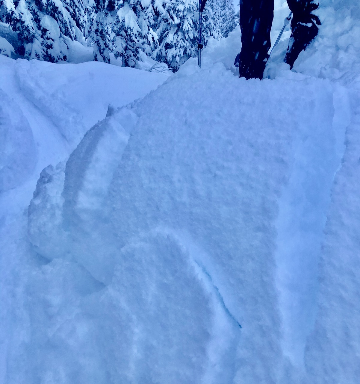
A few small avalanches were seen yesterday in the Tincan Trees (due to small terrain). Seen below is cracking on a very small steep bump where 2′ of new snow failed around the skier testing it.
Due to poor visibility not much is known regarding avalanche activity in the higher terrain. However, Aleph and her partner heard what appeared to be a natural avalanche release on the front side of Seattle Ridge (from Tincan across the highway).
Testing the 2′ of new snow from yesterday on a very small terrain feature. Note the cracking in the new snow. 1.7.21.
Avalanche Problem 1
Storm Slabs
Certain
Very Likely
Likely
Possible
Unlikely
Likelihood
Historic (D4-5)
Very Large (D3)
Large (D2)
Small (D1)
Size
Storm Slabs
Storm Slab avalanches are the release of a cohesive layer (a slab) of new snow that breaks within new snow or on the old snow surface. Storm-slabs typically last between a few hours and few days (following snowfall). Storm-slabs that form over a persistent weak layer (surface hoar, depth hoar, or near-surface facets) may be termed Persistent Slabs or may develop into Persistent Slabs.
Likelihood of Avalanches
Terms such as "unlikely", "likely", and "certain" are used to define the scale, with the chance of triggering or observing
avalanches increasing as we move up the scale. For our purposes, "Unlikely" means that few avalanches could be triggered in avalanche terrain and
natural avalanches are not expected. "Certain" means that humans will be able to trigger avalanches on many slopes, and natural avalanches are expected.
Size of Avalanches
Avalanche size is defined by the largest potential avalanche, or expected range of sizes related to the problem in question.
Assigned size is a qualitative estimate based on the destructive classification system and requires specialists to estimate the harm avalanches may cause to
hypothetical objects located in the avalanche track (AAA 2016, CAA 2014). Under this schema, "Small" avalanches are not large enough to bury humans and are
relatively harmless unless they carry people over cliffs or through trees or rocks. Moving up the scale, avalanches become "Large" enough to bury, injure,
or kill people. "Very Large" avalanches may bury or destroy vehicles or houses, and "Historic" avalanches are massive events capable of altering the landscape.
Stormy weather continues in the backcountry. After 2 feet of new snow was confirmed yesterday (at 1000′ and above), we can add another solid foot to that from last night. The mountains are indeed undergoing a ‘rapid loading’ event, especially at the high elevations where the winds are cooking. Ridgetop easterly winds bumped up to 50mph averages with 79mph gusts at the Sunburst weather station at 4 and 5am. Although snowfall is forecast to lessen today with only 2-4″ expected, the winds are slated to remain elevated.
This new batch of snow is falling on small near surface facets (last week’s fun riding and skiing surface) along with buried surface hoar in places. Yesterday, the storm snow was ‘slabby’ at elevations around 1,000-1,500′. Mainly because the new snow was cohesive, moister and heavier. At the mid-elevations, it was still so loose that it wasn’t acting like a slab….yet. Today could be a different story. As the new snow settles it becomes more cohesive and what was ‘fine’ yesterday could be dangerous today. Keep this in mind in areas like the Tincan Trees where storm slabs now sit up to 3′ thick. Hand pits and jumping on small steep terrain features (like in the photo above) are good ways to test if the new snow is failing on the old snow. Cracking in the snow around you and feeling/hearing any whumpfing are of course signs of instability as well. With so much snow it could be tough to really assess things confidently before an avalanche is triggered. It’s a heads up day.
In the Alpine where the winds are blowing all this snow into stiffer and thicker slabs, all bets are off. You can count those slopes unstable, especially with that old weak surface underneath.
For a safe day, simply sticking to slopes under 30 degrees in steepness and staying out from steep slopes is a way to have fun in the powder without the threat of avalanches.
Mid-elevation storm totals (past 48 hours, 6am Wednesday to 6am Friday):
Turnagain Pass: 2.5-3 feet new snow
Girdwood Valley: 2-2.5 feet new snow
Summit Lake: ~1 foot new snow
Top of the trees on Tincan yesterday; a classic storm day view of the higher terrain in the clouds, snow flakes and wind effect on the snow surface. 1.7.21.
Avalanche Problem 2
Deep Persistent Slabs
Certain
Very Likely
Likely
Possible
Unlikely
Likelihood
Historic (D4-5)
Very Large (D3)
Large (D2)
Small (D1)
Size
Deep Persistent Slabs
Deep Persistent Slab avalanches are the release of a thick cohesive layer of hard snow (a slab), when the bond breaks between the slab and an underlying persistent weak layer deep in the snowpack. The most common persistent weak layers involved in deep, persistent slabs are depth hoar or facets surrounding a deeply buried crust. Deep Persistent Slabs are typically hard to trigger, are very destructive and dangerous due to the large mass of snow involved, and can persist for months once developed. They are often triggered from areas where the snow is shallow and weak, and are particularly difficult to forecast for and manage.
Likelihood of Avalanches
Terms such as "unlikely", "likely", and "certain" are used to define the scale, with the chance of triggering or observing
avalanches increasing as we move up the scale. For our purposes, "Unlikely" means that few avalanches could be triggered in avalanche terrain and
natural avalanches are not expected. "Certain" means that humans will be able to trigger avalanches on many slopes, and natural avalanches are expected.
Size of Avalanches
Avalanche size is defined by the largest potential avalanche, or expected range of sizes related to the problem in question.
Assigned size is a qualitative estimate based on the destructive classification system and requires specialists to estimate the harm avalanches may cause to
hypothetical objects located in the avalanche track (AAA 2016, CAA 2014). Under this schema, "Small" avalanches are not large enough to bury humans and are
relatively harmless unless they carry people over cliffs or through trees or rocks. Moving up the scale, avalanches become "Large" enough to bury, injure,
or kill people. "Very Large" avalanches may bury or destroy vehicles or houses, and "Historic" avalanches are massive events capable of altering the landscape.
Hidden now between 4-7′ below the snow surface is that Dec. 1 rain crust/facet combination that exists at elevations between 1,000′ and 2,500′. Despite being an old buried crust, it continues to degrade and weaken; turning into a faceted layer in places. It has shown to be the weakest on the non-motorized side of Turnagain pass. Although unlikely that a person could trigger an avalanche on this layer, which at this point would be very large and dangerous, it’s worth keeping in mind and remaining conservative. Rapid loading events, such as we are seeing now, can sometimes produce unusual avalanches breaking deeper in the pack. Hence, it’s another day to play it mellow.
Weather
Fri, January 8th, 2021
Yesterday: Heavy snowfall was over most of the forecast zone with rain falling around 400′ and below. 24-hour snow totals were near 16″ at mid-elevations with Summit Lake only seeing 6″ or so (see snow and water numbers below in the chart). Ridgetop winds averaged 20-40mph from the east and have bumped up early this morning to near 50mph with gusts near 80mph. Temperatures were near 32F at mid-elevations and in the mid 20’sF along ridgelines; at sea level in the upper 30’sF.
Today: Light to moderate snowfall is expected to continue through today with slowly decreasing temperatures and rain/snow line making its way to around 200′ by tonight. Around 2-4″ is expected today and another 2-4″ tonight. Ridgetop easterly winds are ramping up currently (50mph averages) and should stay strong through the day (25-40mph averages). Temperatures should hover near 32F at 1,000′ and in the low to mid 20’sF along ridgelines.
Tomorrow: After a brief break tomorrow morning another round of snow and wind is forecast to head in as a series of low pressure systems move into the Gulf. Temperatures look to rise a few degrees tomorrow and around 2-4″ of snow is forecast at the mid and upper elevations with rain at sea level. Ridgetop winds should remain elevated (averages 20-40mph). This stormy weather could last well into the middle part of the week.
This is a general backcountry avalanche advisory issued for Turnagain Arm with Turnagain Pass as the core advisory area.
This advisory does not apply to highways, railroads or operating ski areas.

 Testing the 2′ of new snow from yesterday on a very small terrain feature. Note the cracking in the new snow. 1.7.21.
 Top of the trees on Tincan yesterday; a classic storm day view of the higher terrain in the clouds, snow flakes and wind effect on the snow surface. 1.7.21.