Turnagain Pass Avalanche Forecast RSS

Archives
ARCHIVED FORECAST - All forecasts expire after 24 hours from the posting date/time.
Issued
Thu, January 7th, 2021 - 7:00AM
Expires
Fri, January 8th, 2021 - 7:00AM
Forecaster
Aleph Johnston-Bloom
Avalanche risk The Bottom Line

The avalanche danger is CONSIDERABLE above 1000′ today. New snow and strong winds have created dangerous avalanche conditions. Natural avalanches are possible and human triggered storm and wind slabs, 1-3′ deep are likely.  Cautious route-finding and conservative decision-making are essential. Look for signs of instability and choose terrain wisely.

Below 1000′ the avalanche danger is MODERATE. Human triggered wet loose avalanches are possible.

Special Announcements

Heading to Hatcher? Don’t forget to check the Thursday Conditions Summary at hpavalanche.org.

Thanks to our sponsors!
Thu, January 7th, 2021
Alpine
Above 2,500'
Considerable (3)
Avalanche risk
Treeline
1,000'-2,500'
Considerable (3)
Avalanche risk
Below Treeline
Below 1,000'
Moderate (2)
Avalanche risk
Alpine
Above 2,500'
Avalanche risk
Considerable (3)
Treeline
1,000'-2,500'
Avalanche risk
Considerable (3)
Below Treeline
Below 1,000'
Avalanche risk
Moderate (2)
Danger Scale:
No Rating (0)
Low (1)
Moderate (2)
Considerable (3)
High (4)
Extreme (5)
Avalanche Problem 1
  • Storm Slabs
    Storm Slabs
  • Almost Certain
    Very Likely
    Likely
    Possible
    Unlikely
    Likelihood
  • Historic (D4-5)
    Very Large (D3)
    Large (D2)
    Small (D1)
    Size
Storm Slabs
Storm Slab avalanches are the release of a cohesive layer (a slab) of new snow that breaks within new snow or on the old snow surface. Storm-slabs typically last between a few hours and few days (following snowfall). Storm-slabs that form over a persistent weak layer (surface hoar, depth hoar, or near-surface facets) may be termed Persistent Slabs or may develop into Persistent Slabs.

Likelihood of Avalanches
Terms such as "unlikely", "likely", and "certain" are used to define the scale, with the chance of triggering or observing avalanches increasing as we move up the scale. For our purposes, "Unlikely" means that few avalanches could be triggered in avalanche terrain and natural avalanches are not expected. "Certain" means that humans will be able to trigger avalanches on many slopes, and natural avalanches are expected.

Size of Avalanches
Avalanche size is defined by the largest potential avalanche, or expected range of sizes related to the problem in question. Assigned size is a qualitative estimate based on the destructive classification system and requires specialists to estimate the harm avalanches may cause to hypothetical objects located in the avalanche track (AAA 2016, CAA 2014). Under this schema, "Small" avalanches are not large enough to bury humans and are relatively harmless unless they carry people over cliffs or through trees or rocks. Moving up the scale, avalanches become "Large" enough to bury, injure, or kill people. "Very Large" avalanches may bury or destroy vehicles or houses, and "Historic" avalanches are massive events capable of altering the landscape.

Signal Word Size (D scale) Simple Descriptor
Small 1 Unlikely to bury a person
Large 2 Can bury a person
Very Large 3 Can destroy a house
Historic 4 & 5 Can destroy part or all of a village
More info at Avalanche.org

With over a foot of new snow (1-1.5″ of SWE) and strong winds in the last 24 hours, caution is advised today. Human triggered avalanches are likely and natural avalanches are possible with snowfall and elevated ridgetop winds forecast to continue. Rain/snow line fluctuated yesterday from 200′-500′, was forecast to be around 800′ overnight and is expected to rise to 1000′ today.

This storm is ‘upside down’ with warm snow falling on colder snow. In addition, under this new storm snow is a thin layer of weak snow (surface hoar and near surface facets) that formed during the cold clear weather at the end of last week. Watch for sensitive storm slabs on steep slopes in wind protected terrain. In wind exposed terrain expect slabs to be potentially more touchy and deeper. Yesterday observers across the area reported developing wind slabs as the day progressed and a skier triggered a small slab in the Tincan Trees. Since early yesterday morning east winds have averaged 20-40 mph, with peak gusts on Sunburst at 74 mph and 70 mph on Maxs. Triggering a wind slab 1-3′ deep is likely today on steep slopes or gullies with wind deposited snow. Remember with similar winds today and active transport, natural avalanches will be possible. Pay attention to what slopes are above you.

If you do venture out look for signs of instability and wind effect:

  • Recent avalanches? There could have been some natural avalanches overnight.
  • Cracking in the snow around your skis, board or machine.
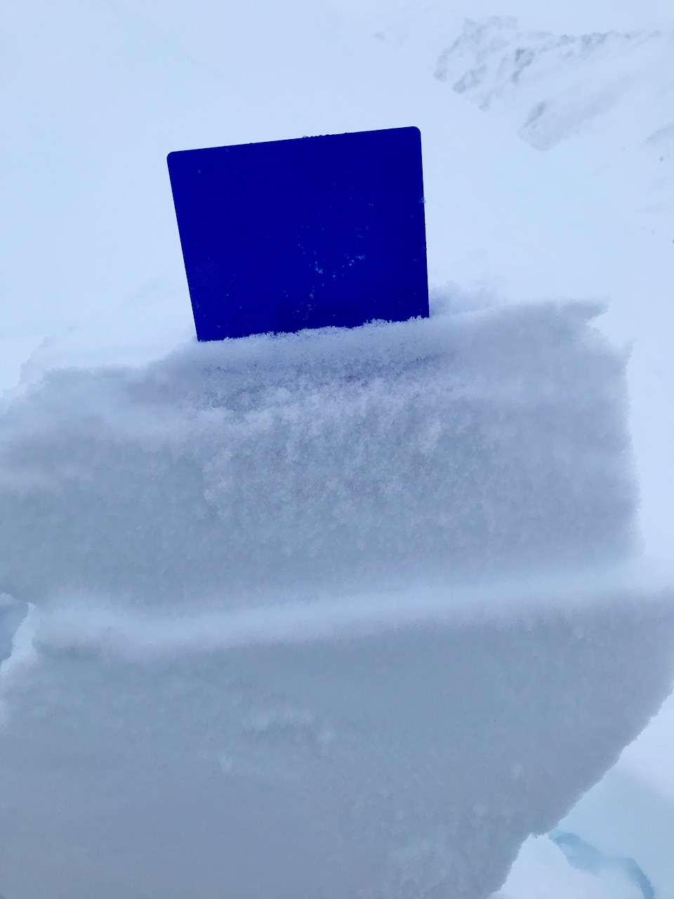
  • Stiff snow over softer snow and wind pillows or drifts.
  • Whumpfing (collapsing) of the snowpack

Cornices:  As always, watch for cornices and give them a wide berth. New snow and wind increase the likelihood that these will break.

Loose snow avalanches (sluffs):  In steep terrain protected from the wind watch for sluffing in the new snow that has not formed a slab. In steep terrain that is below 1000′ where raining is falling, there is a chance of triggering wet loose avalanches in the saturated snow.

It’s a day to carefully evaluate terrain and consequences if an avalanche does release.  Choosing low angle slopes without steep slopes above is great way to enjoy the new snow without worry.

On Monday a thin layer of weak snow was buried by just a skiff of snow. This is now buried 1-3′ deep. Triggering an avalanche that fails on this layer is likely today. Sunburst, 1.4.21.


Avalanche Problem 2
  • Deep Persistent Slabs
    Deep Persistent Slabs
  • Almost Certain
    Very Likely
    Likely
    Possible
    Unlikely
    Likelihood
  • Historic (D4-5)
    Very Large (D3)
    Large (D2)
    Small (D1)
    Size
Deep Persistent Slabs
Deep Persistent Slab avalanches are the release of a thick cohesive layer of hard snow (a slab), when the bond breaks between the slab and an underlying persistent weak layer deep in the snowpack. The most common persistent weak layers involved in deep, persistent slabs are depth hoar or facets surrounding a deeply buried crust. Deep Persistent Slabs are typically hard to trigger, are very destructive and dangerous due to the large mass of snow involved, and can persist for months once developed. They are often triggered from areas where the snow is shallow and weak, and are particularly difficult to forecast for and manage.

Likelihood of Avalanches
Terms such as "unlikely", "likely", and "certain" are used to define the scale, with the chance of triggering or observing avalanches increasing as we move up the scale. For our purposes, "Unlikely" means that few avalanches could be triggered in avalanche terrain and natural avalanches are not expected. "Certain" means that humans will be able to trigger avalanches on many slopes, and natural avalanches are expected.

Size of Avalanches
Avalanche size is defined by the largest potential avalanche, or expected range of sizes related to the problem in question. Assigned size is a qualitative estimate based on the destructive classification system and requires specialists to estimate the harm avalanches may cause to hypothetical objects located in the avalanche track (AAA 2016, CAA 2014). Under this schema, "Small" avalanches are not large enough to bury humans and are relatively harmless unless they carry people over cliffs or through trees or rocks. Moving up the scale, avalanches become "Large" enough to bury, injure, or kill people. "Very Large" avalanches may bury or destroy vehicles or houses, and "Historic" avalanches are massive events capable of altering the landscape.

Signal Word Size (D scale) Simple Descriptor
Small 1 Unlikely to bury a person
Large 2 Can bury a person
Very Large 3 Can destroy a house
Historic 4 & 5 Can destroy part or all of a village
More info at Avalanche.org

We have been tracking the Dec. 1 rain crust/facet layer that is buried 3-6’ deep, which appears to be weakest on the non-motorized side of Turnagain pass. It is still unlikely that a human could trigger an avalanche on this layer. However, as new snow falls with rapid wind loading, it is an additional reason reason to be conservative today. If this set-up does reach it stress point triggering an avalanche on this layer could be very large and dangerous.

Weather
Thu, January 7th, 2021

Yesterday: Skies were cloudy and rain and snow fell throughout the day. Rain/snow line fluctuated reaching as high as 500′ during the day, with 5-7″ of snow accumulating at upper elevations. Winds were strong, averaging 25-35 mph, gusting 40-60 mph throughout the day and overnight. Temperatures were in the low to mid 30°s at sea level and the 20°Fs at ridgetops. Precipitation continued overnight with another 6-8″ of snow falling with rain below 500′.

Today: Snow and rain will continue with another 6-8″ of snow (0.6 SWE) forecast and rain/snow line around 1000′. Temperatures will be in the high 30°Fs at sea level and 20°Fs at upper elevations. East winds will continue 20-30 mph with gusts into the 40s and 50s. Snow, rain (another 0.6 SWE) and elevated winds will continue overnight with temperatures holding steady. Precipitation rates and winds will potentially ease early Friday morning. However, there is some forecast uncertainty going into the next couple days.

Tomorrow: Rain and snow showers with with 10-15 mph, gusting into the 20s. Temperatures will be in the 20°Fs at ridgetops and high 30°Fs at sea level. The active weather pattern continues through the weekend. Stay tuned!

PRECIPITATION 24-hour data (6am – 6am)

Temp Avg (F) Snow (in) Water (in) Snow Depth (in)
Center Ridge (1880′) 31 14 1.3 87
Summit Lake (1400′) 31 4 0.3 33
Alyeska Mid (1700′) 31 11 1.0 87

RIDGETOP 24-hour data (6am – 6am)

Temp Avg (F) Wind Dir Wind Avg (mph) Wind Gust (mph)
Sunburst (3812′) 21 NE 32 74
Seattle Ridge (2400′) 25 E 13 66
Observations
Recent Observations for Turnagain Pass
Date Region Location
05/22/23 Turnagain Avalanche: Tincan
05/12/23 Turnagain Avalanche: Tincan, Sunburst, Magnum, Cornbiscuit
05/07/23 Turnagain Observation: Tincan – Bear Tracks
05/05/23 Turnagain Observation: Seattle Ridge
05/02/23 Turnagain Observation: Cornbiscuit
05/02/23 Turnagain Observation: Seward Hwy Turnagain Pass
04/30/23 Turnagain Observation: Magnum
04/29/23 Turnagain Observation: Tincan
04/28/23 Turnagain Avalanche: Taylor Pass/Pastoral
04/28/23 Turnagain Avalanche: Tincan
Riding Areas
Updated Thu, June 01st, 2023

Status of riding areas across the Chugach NF is managed by the Glacier and Seward Ranger Districts, not avalanche center staff. Riding area information is posted as a public service to our users and updated based on snow depth and snow density to prevent resource damage at trailhead locations. Riding area questions contact: mailroom_r10_chugach@fs.fed.us

Area Status Weather & Riding Conditions
Glacier District
Johnson Pass
Closed
Closed May 15.
Placer River
Closed
Closed May 15.
Skookum Drainage
Closed
Will close to motorized use on April 1, 2023 per the National Forest Plan.
Turnagain Pass
Closed
Will close on June 1.
Twentymile
Closed
Scheduled closure May 1.
Seward District
Carter Lake
Closed
Scheduled closure May 1.
Lost Lake Trail
Closed
Scheduled closure May 1.
Primrose Trail
Closed
Scheduled closure May 1.
Resurrection Pass Trail
Closed
Closed to motorized use for the 2022/23 winter season per Forest Plan. Open next season.
Snug Harbor
Closed
Extended opening until May 15.
South Fork Snow River Corridor
Closed
Scheduled closure May 1.
Summit Lake
Closed
Scheduled closure May 1.

Subscribe to Turnagain Pass
Avalanche Forecast by Email

This is a general backcountry avalanche advisory issued for Turnagain Arm with Turnagain Pass as the core advisory area. This advisory does not apply to highways, railroads or operating ski areas.