Turnagain Pass RSS

Archives
ARCHIVED - Forecasts expire after 24 hours.
Issued
Sat, March 16th, 2019 - 7:00AM
Expires
Sun, March 17th, 2019 - 7:00AM
Forecaster
Graham Predeger
Avalanche risk The Bottom Line

The avalanche danger is  HIGH  for a fourth consecutive day given the continuation of a series of warm, wet and windy storms depositing heavy snow and rain in rapid succession in the Turnagain Pass area.    Travel in avalanche terrain is not recommended again today.    Avoid slopes 30 degrees or steeper, including runout zones.  

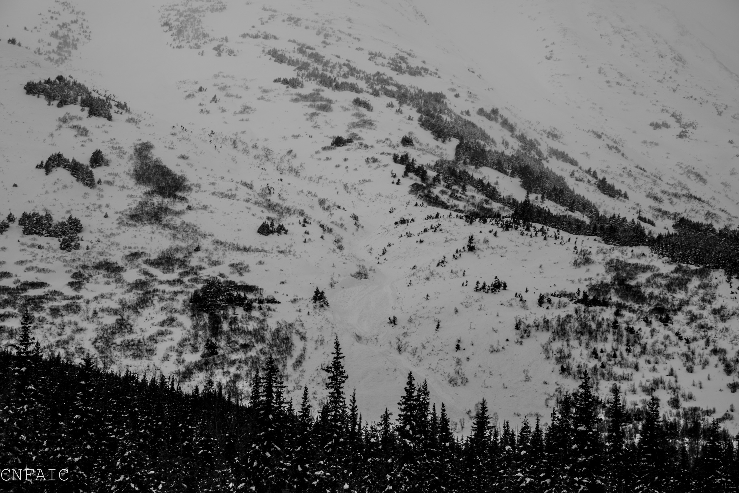
SUMMIT LAKE (& INTERIOR EASTERN KENAI MTS)   €“ Areas around Summit Lake have effectively doubled their seasonal snowpack in the past week and dropped up to a 30 € storm slab on a very weak base of facets.   Large to very large human triggered avalanches are very likely again today.  Travel in avalanche terrain is NOT recommended in these zones.

SEWARD/LOST LAKE   €“ Coastal areas such as Seward have seen big precip numbers this week, much in the form of rain.   Natural avalanches large enough to bury, injure or kill a person have been observed. Again,  travel in avalanche terrain is NOT recommended.

Special Announcements
  • Please be kind to our DOT plow drivers and give them the space they need to clear the Seward highway corridor.   The more efficient they can be with keeping the highway clear, the quicker they can push back our winter recreation parking areas.  
  • Turnagain Pass 20 years later: On Saturday, March 23rd from 12-2pm swing by the Turnagain Pass moto lot and meet the CNFAIC avalanche forecasters, bring and test your avalanche rescue gear, ask questions and learn about the history of Turnagain Pass and the avalanche center. We’ll even have a few beacons buried so you can test your skills before heading into the hills!
  • Heading to Hatcher Pass? Be sure to check out the Hatcher Pass Avalanche Center Saturday avalanche forecast  HERE.
Sat, March 16th, 2019
Alpine
Above 2,500'
4 - High
Avalanche risk
Treeline
1,000'-2,500'
4 - High
Avalanche risk
Below Treeline
Below 1,000'
4 - High
Avalanche risk
0 - No Rating
1 - Low
2 - Moderate
3 - Considerable
4 - High
5 - Extreme
Avalanche risk Avalanche risk Avalanche risk Avalanche risk Avalanche risk
Travel Advice Generally safe avalanche conditions. Watch for unstable snow on isolated terrain features. Heightened avalanche conditions on specific terrain features. Evaluate snow and terrain carefully; identify features of concern. Dangerous avalanche conditions. Careful snowpack evaluation, cautious route-finding, and conservative decision-making essential. Very dangerous avalanche conditions. Travel in avalanche terrain not recommended. Extraordinarily dangerous avalanche conditions. Avoid all avalanche terrain.
Likelihood of Avalanches Natural and human-triggered avalanches unlikely. Natural avalanches unlikely; human-triggered avalanches possible. Natural avalanches possible; human-triggered avalanches likely. Natural avalanches likely; human-triggered avalanches very likely. Natural and human-triggered avalanches certain.
Avalanche Size and Distribution Small avalanches in isolated areas or extreme terrain. Small avalanches in specific areas; or large avalanches in isolated areas. Small avalanches in many areas; or large avalanches in specific areas; or very large avalanches in isolated areas. Large avalanches in many areas; or very large avalanches in specific areas. Very large avalanches in many areas.
Avalanche Problem 1
  • Storm Slabs
    Storm Slabs
  • Certain
    Very Likely
    Likely
    Possible
    Unlikely
    Likelihood
  • Historic (D4-5)
    Very Large (D3)
    Large (D2)
    Small (D1)
    Size
Storm Slabs
Storm Slab avalanches are the release of a cohesive layer (a slab) of new snow that breaks within new snow or on the old snow surface. Storm-slabs typically last between a few hours and few days (following snowfall). Storm-slabs that form over a persistent weak layer (surface hoar, depth hoar, or near-surface facets) may be termed Persistent Slabs or may develop into Persistent Slabs.

Likelihood of Avalanches
Terms such as "unlikely", "likely", and "certain" are used to define the scale, with the chance of triggering or observing avalanches increasing as we move up the scale. For our purposes, "Unlikely" means that few avalanches could be triggered in avalanche terrain and natural avalanches are not expected. "Certain" means that humans will be able to trigger avalanches on many slopes, and natural avalanches are expected.

Size of Avalanches
Avalanche size is defined by the largest potential avalanche, or expected range of sizes related to the problem in question. Assigned size is a qualitative estimate based on the destructive classification system and requires specialists to estimate the harm avalanches may cause to hypothetical objects located in the avalanche track (AAA 2016, CAA 2014). Under this schema, "Small" avalanches are not large enough to bury humans and are relatively harmless unless they carry people over cliffs or through trees or rocks. Moving up the scale, avalanches become "Large" enough to bury, injure, or kill people. "Very Large" avalanches may bury or destroy vehicles or houses, and "Historic" avalanches are massive events capable of altering the landscape.

Signal Word Size (D scale) Simple Descriptor
Small 1 Unlikely to bury a person
Large 2 Can bury a person
Very Large 3 Can destroy a house
Historic 4 & 5 Can destroy part or all of a village
More info at Avalanche.org

Each low-pressure event impacting our area over the past week seems to be bringing slightly warmer temperatures than the last; today will be no exception.  As temperatures increase, the rain/ snow line may reach as high as 2,000’ as this next bout of weather impacts the eastern Kenai Peninsula this weekend.  What does this mean for avalanche activity today?  It means that rain on snow may initiate natural avalanches in the treeline elevations where we’ve seen mostly snow for the past 3+ days.  Any avalanches today will be large and un-survivable as storm slabs alone are 2-3’ deep.  Add winds to that or the potential for an avalanche to step down into weaker layers deeper in the snowpack and we’re flirting with the potential for 5-6’+ deep avalanches.

Though observations and info from the alpine (above) 2,500’ have been minimal since Tuesday, an additional 8-16″ of snow forecated and strong easterly winds over known weak layers and crusts create a serious concern for large and destructive avalanches today.  In channeled terrain, debris was running to the valley floor and all the way to sea level in some cases yesterday.  Today the message is simple – Avoid all avalanche terrain, this includes slopes steeper than 30 degrees and all runout zones. 

South of Turnagain Pass: A brief weather window on Thursday allowed observers to view a plethora of natural avalanches that ran mid-storm.  Given a shallower snowpack in these areas, this week’s load is proving generous enough to tip the stress vs. strength balance south of the core Turnagain Pass area.  Suspect areas include Johnson Pass, Lynx Creek and Summit Lake.  

Debris in channelled terrain in the bottom of east facing terrain at the base of Twin Peaks. Just south of Turnagain Pass.  Photo: 3/14.

Storm Totals (Wed 6am – Sat 6am): 

  • Turnagain Pass 1800’:  29” (settled snow) — 4.3” SWE
  • Girdwood-Alyeska Midway 1700’: ~30” — 3.14” SWE
  • Summit Lake 1400’: ~19” — 1.5” SWE
  • Portage Valley 95’: ~5-6 ft snow in upper elevations — 6.25” rain at reporting station
Weather
Sat, March 16th, 2019

Yesterday:  Temperatures in the mid to upper 30’s kept rain the dominant precip type below about ~700′.   Turnagain Pass (1,880′) only saw ~3 € of wet, heavy snow (.9 € water) as accumulation was barely keeping up with settlement rates.   Ridgetop winds were sustained from the east in the mid 30’s €“ 40mph with gusts into the low 70’s at Sunburst.

Today:  Temperatures continue to climb into the high 30’s at 1,000′ with the rain/ snow line anticipated to be in the 1,800′ €“ 2,000′ range.   On average we can expect another ~1 € of water though areas such as Portage and Girdwood could see more.   In the alpine this translates to another 8-16 € of snow.  

Tomorrow: The active weather pattern continues as yet another surface low moves into southcentral AK.   Expect more rain in the lower elevations, moderate to strong southeasterly winds and ample snow/ whiteout in the alpine.   Rain/ snow line looks to be in the 1,800-2,400′ range.

PRECIPITATION 24-hour data (6am – 6am)

  Temp Avg (F) Snow (in) Water (in) Snow Depth (in)
Center Ridge (1880′)  32  3  .9 102  
Summit Lake (1400′)  35  0 .2   37  
Alyeska Mid (1700′) 32   0   .89   89  

RIDGETOP 24-hour data (6am – 6am)

  Temp Avg (F) Wind Dir Wind Avg (mph) Wind Gust (mph)
Sunburst (3812′)  23  ENE  42 88  
Seattle Ridge (2400′)  28 n/a *  n/a*  n/a*

*Seattle Ridge weather station is not reporting reliable wind data at this time.

Observations
Recent Observations for Turnagain Pass
Date Region Location
04/16/24 Turnagain Observation: Cornbiscuit
04/15/24 Turnagain Observation: Taylor Pass
04/15/24 Turnagain Observation: Seward Highway – Tern Lake to Portage
04/14/24 Turnagain Observation: Sunburst
04/14/24 Turnagain Observation: Turnagain Pass Snomo
04/13/24 Turnagain Observation: Spokane Creek
04/11/24 Turnagain Observation: Tincan
04/10/24 Turnagain Avalanche: Seattle Ridge
04/10/24 Turnagain Observation: Cornbiscuit South Face
04/10/24 Turnagain Avalanche: Tincan
Riding Areas

The riding areas page has moved. Please click here & update your bookmarks.


Subscribe to Turnagain Pass
Avalanche Forecast by Email

This is a general backcountry avalanche advisory issued for Turnagain Arm with Turnagain Pass as the core advisory area. This advisory does not apply to highways, railroads or operating ski areas.