Turnagain Pass
|
![]() ![]() |
The avalanche danger will rise to HIGH danger above 2000 ft by this evening for Turnagain Pass, Girdwood, and Portage Valley. Human triggered avalanches 1-3 ft deep are likely this afternoon and large natural avalanches will become more likely as snow totals increase. Below 2000 ft expect storm slabs to increase to 1+ feet thick by this afternoon. Below 1000 ft the avalanche danger is CONSIDERABLE where wet-loose avalanche are possible or a natural avalanche from above could run later in the day. Cautious route-finding and conservative terrain choices are essential today, and travel is not recommended in avalanche terrain by this evening. Any obvious clues like whumpfing, shooting cracks, and natural avalanches will be red flag warning to stay out of avalanche terrain.
PORTAGE/PLACER VALLEY: Natural avalanches are possible today that could send debris to valley floors. Areas with steep slopes and avalanche terrain above you, such as the Byron Glacier Trail, should be avoided.
JOHNSON PASS/SUMMIT LAKE: There is a shallow snowpack with a generally poor structure. Strong winds and new snow today will be adding stress to the snowpack. In addition to storm slabs a human could overload buried weak layers, producing an unexpected large slab avalanche.
LOST LAKE: Dangerous avalanche conditions are expected in the Lost Lake and Seward regions as well 2-3 feet of new snow and strong winds.
![]() |
![]() |
![]() |
![]() |
![]() |
|
Travel Advice | Generally safe avalanche conditions. Watch for unstable snow on isolated terrain features. | Heightened avalanche conditions on specific terrain features. Evaluate snow and terrain carefully; identify features of concern. | Dangerous avalanche conditions. Careful snowpack evaluation, cautious route-finding, and conservative decision-making essential. | Very dangerous avalanche conditions. Travel in avalanche terrain not recommended. | Extraordinarily dangerous avalanche conditions. Avoid all avalanche terrain. |
Likelihood of Avalanches | Natural and human-triggered avalanches unlikely. | Natural avalanches unlikely; human-triggered avalanches possible. | Natural avalanches possible; human-triggered avalanches likely. | Natural avalanches likely; human-triggered avalanches very likely. | Natural and human-triggered avalanches certain. |
Avalanche Size and Distribution | Small avalanches in isolated areas or extreme terrain. | Small avalanches in specific areas; or large avalanches in isolated areas. | Small avalanches in many areas; or large avalanches in specific areas; or very large avalanches in isolated areas. | Large avalanches in many areas; or very large avalanches in specific areas. | Very large avalanches in many areas. |
Signal Word | Size (D scale) | Simple Descriptor |
Small | 1 | Unlikely to bury a person |
Large | 2 | Can bury a person |
Very Large | 3 | Can destroy a house |
Historic | 4 & 5 | Can destroy part or all of a village |
An active weather pattern continues for Eastern Turnagain Arm and another powerful storm is bringing strong winds and heavy snow to our region today. The National Weather Service has issued a Special Weather Statement due to 2-3 ft of snow expected in the mountains of Girdwood, Turnagain Pass and Moose Pass by Friday. Overnight Portage Valley has already seen 0.6 inches SWE (mix of rain and snow) and Turnagain Pass snow stake has ~4 in of new snow overnight. Today 12 inches of snow is expected for Turnagain Pass and Girdwood by early evening and another 1-2 ft of snow is possible overnight. Strong ridgetop winds 30-40 mph from Northeast will continue through the day and build into the 60s mph and gusts in the 80s mph by this evening. This means the avalanche hazard will be increasing throughout the day and natural avalanches will be more likely as today’s storm progresses. The more snow that falls the greater the avalanche hazard. With such strong winds storm slabs could grow to 1-2 ft in the alpine before dark. Below 2000 ft where a stout crust has formed storm slabs could be easily triggered on this slick bed surface as snowfall totals increase. Avoid all avalanche terrain if you see any natural avalanches and be prepared to end your day early due to increasing danger.
Persistent Slabs: To compound today’s avalanche hazard, there is also weak snow (facets and buried surface hoar) buried under 2-3 ft of new snow from this weekend. Yesterday we heard about a skier partially buried in an avalanche between Placer and Grandview at around 4000 ft on NW aspect. According to a witness in the area the crown was 3 ft deep by 300 ft wide and the skier was partial buried, but okay. This is a good reminder that the size of the avalanche hazard is increasing from large to very large with the addition of more snow and strong wind today. This poor structure is most concerning above 2000 ft where a stout crust formed on Monday night.
South of Turnagain in Summit Lake a variety of old weak layers in the mid and base of the snowpack. The Southerly storm track direction is expected to impact Summit Lake with up to 1-2 ft of new snow by Friday. This wasn’t the case last weekend where only a few inches fell. Be aware that more uncertainty exists in this zone for triggering dangerous avalanche in a variety of old weak layers, and rapid loading from new snow and strong winds could also cause natural avalanches by this evening.
Wet Snow: A mix if rain and snow is expected below 1000 ft. In Portage and Placer Valley where above freezing temperatures mid-day could cause heavy rain, loose-wet avalanches are possible today in lower elevations.
Storm totals through Friday. This map is referring to how much water weight is expected for the storm. For example Turnagain Pass is expected to get 2.6 inches of water weight which equals ~ 2.5-3 feet of snow.
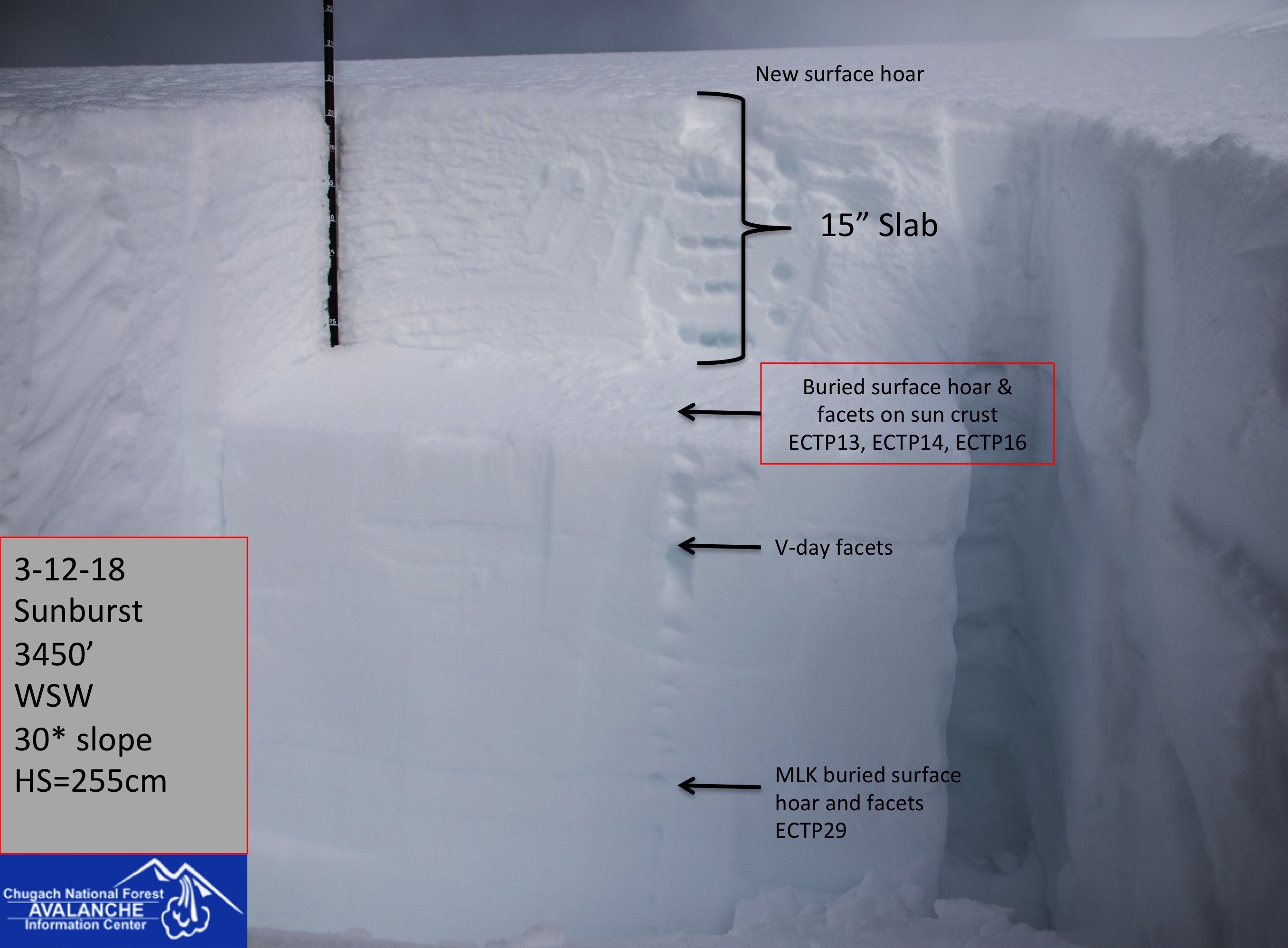
Today’s storm could overload an older weak layer deeper in the snowpack. Stability tests this week have been showing consistent propagation on buried surface hoar and facets 1.5-3 ft below the surface.
Yesterday: Skies were mostly clear in the morning becoming cloudy by late afternoon. Ridge top winds from the NE were Light becoming 15-25 mph by early afternoon. Temperature remained in low to mid 20s F in upper elevations, ~30F at lower elevations. Overnight snow started falling. Turnagain Pass has an estimated 4 inches of new snow and Alyeska midway station 3 inches new.
Today: A strong storm is tracking over Eastern Turnagain Arm. Heavy snowfall is expected this afternoon through tomorrow morning. A foot of new snow is possible by 8pm and another 1-2 ft is expected overnight. Strong Easterly ridge top winds 30-40 mph will increase into the 60s with gusts in the 80s mph by early evening. Temperatures should remain in the 20s F in the mid and upper elevations, but above freezing temps and rain is possible near sea level. Rain/snow line could reach as high as 1000 ft by this evening.
Tomorrow: Heavy snow fall is expected to decrease by early afternoon tomorrow, but snow showers will continue through the day. Ridgetop winds are also expected to decrease throughout the day from strong to moderate by the evening before another round of precip and strong winds pick up again Friday evening into Saturday. More storms are expected over the weekend and into next week.
*Seattle Ridge anemometer was freed of rime and wind data started around 4pm on 3/12/19
Temp Avg (F) | Snow (in) | Water (in) | Snow Depth (in) | |
Center Ridge (1880′) | 29 | 2″ – 4″ | 0.2 | 70 |
Summit Lake (1400′) | 28 | 0 | 0 | 27 |
Alyeska Mid (1700′) | 30 | 3 | .08 | 73 |
Temp Avg (F) | Wind Dir | Wind Avg (mph) | Wind Gust (mph) | |
Sunburst (3812′) | 20 | ENE | 17 | 43 |
Seattle Ridge (2400′) | 25 | *ESE | *7 | *29 |
Date | Region | Location | Observer |
---|---|---|---|
10/27/24 | Turnagain | Observation: Tincan | Michael Kerst |
10/21/24 | Turnagain | Observation: Turnagain Pass Road Observation | Trevor Clayton |
10/19/24 | Turnagain | Observation: Tincan – Below Todds Run | Andy Moderow |
10/18/24 | Turnagain | Observation: Taylor Pass | Eli Neuffer |
10/15/24 | Turnagain | Observation: Tincan Common | John Sykes Forecaster |
10/14/24 | Turnagain | Avalanche: Tincan | CNFAC Staff |
05/13/24 | Turnagain | Observation: Eddie’s, Sunburst, Seattle, Cornbiscuit, Pete’s South | H Thamm |
05/13/24 | Turnagain | Observation: Turnagain Pass non-motorized side | Amy Holman |
05/12/24 | Turnagain | Observation: Warm up Bowl | Tony Naciuk |
05/07/24 | Turnagain | Observation: Turnagain Pass Wet Slabs | A S |
The riding areas page has moved. Please click here & update your bookmarks.
Subscribe to Turnagain Pass
Avalanche Forecast by Email