Turnagain Pass Avalanche Forecast
|
![]() ![]() |
The avalanche danger is MODERATE in the Alpine and Treeline zones. Triggering a fresh wind slab 6-12 € thick is possible on steep terrain features. Active wind loading could add stress to a more dangerous problem where triggering a large slab avalanche 2-3′ thick remains possible on steep slopes above 2,000′. These slabs can be triggered remotely from ridgelines and will be large enough to bury, injure or kill a person. Be on the lookout for shooting cracks and blowing snow, identify wind loaded aspects and avoid high consequence terrain. Give cornices a wide berth, and avoid travel under glide cracks.
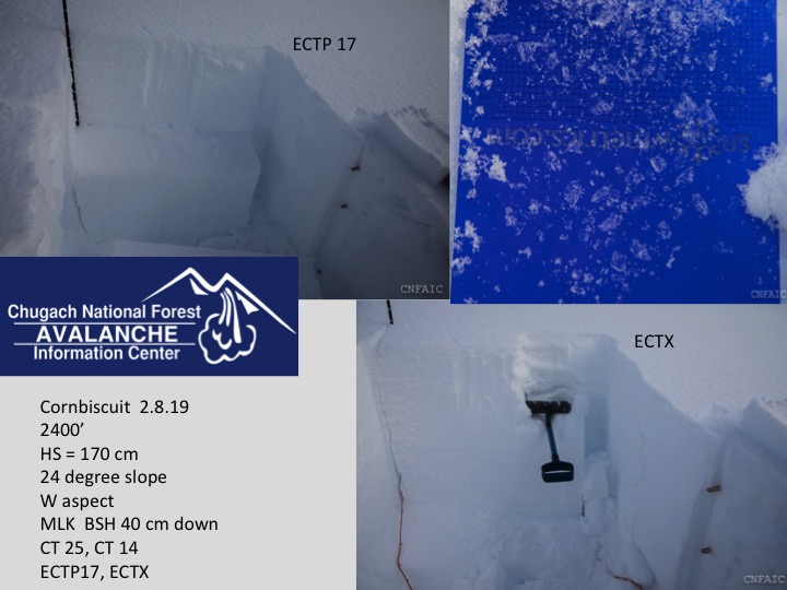
SUMMIT LAKE / JOHNSON PASS: Areas south of Turnagain Pass harbor a thinner, weaker snowpack with multiple weak layers present including the MLK buried surface hoar. Blowing snow, whumpfing, shooting cracks or any signs of avalanche activity are reminders to avoid avalanche terrain.
LOST LAKE / SEWARD: Thursday we received a report of a human triggered avalanche where someone was caught, carried and injured on the Harding Icefield trail and suffered a minor head injury. This avalanche occurred, February 2nd. For more details read the accident report HERE. This area has very little snowpack info and extra caution is advised.
Signal Word | Size (D scale) | Simple Descriptor |
Small | 1 | Unlikely to bury a person |
Large | 2 | Can bury a person |
Very Large | 3 | Can destroy a house |
Historic | 4 & 5 | Can destroy part or all of a village |
Sunburst weather station is already reporting Easterly winds 15-25 with gusts in the mid 30s to low 40s mph. Roughly 4-6” of loose snow is available for transport and a few addition inches may fall throughout the day. Expect wind slabs 6-12” to form on leeward aspects and cross load terrain features. Visibility will make travel challenging today. Avoid wind loaded features and pay attention to blowing snow and shooting cracks. Triggering even a small wind slab in the wrong place could have high consequences. Don’t forget about the deeper more dangerous avalanche problem where triggering a small wind slab could step down into a much bigger persistent slab avalanche.
Signal Word | Size (D scale) | Simple Descriptor |
Small | 1 | Unlikely to bury a person |
Large | 2 | Can bury a person |
Very Large | 3 | Can destroy a house |
Historic | 4 & 5 | Can destroy part or all of a village |
The MLK buried surface hoar is roughly 1-3′ deep has been responsible for 13 human triggered avalanches over the past two weeks. The last one was four days ago on Eddies. On that day snowpack tests were pointing toward a stabilizing weak layer and then the 2′-3′ deep avalanche was triggered remotely from the ridge on a steep, unsupported slope. This avalanche illustrates that snow pit tests are unreliable for the current problem. Furthermore, no signs of instability have been seen in conjunction with several of the large human triggered avalanches on this layer.
Moderate winds will be adding additional stress to the snowpack and it is possible a person or snowmachine could tip the balance. Over the last few days many people have been pushing into steeper terrain without incident, but don’t forget this is the kind of avalanche problem where several tracks may be on a slope before someone finds a trigger point and the whole slopes avalanches.
What to keep in mind today:
1- This weak layer is widespread in the region and seems to be particularly suspect between 2000′-2500′ due to a melt-freeze crust associated with it.
2- Use safe travel protocol. Expose only one person at a time (this includes paying attention to other groups in the area), watch partners, stop in safe zones and be rescue ready.
3- Wind loaded steep features, large connected and unsupported slopes are the most suspect. As always, one can simply avoid high conseqence terrain and stick to slopes under 35 degrees with nothing steeper above to avoid the issue.
A remote triggered slab on Eddies released on a layer of buried surface hoar on Wednesday (2/6/19.) We have been refering to this layer as the MLK buried surface hoar. It was buried on Martin Luther King day.
Good example of how stability tests have been showing unreliable results. Some tests show propagation potential while other are not reactive in the same pit location. Cornbiscuit on 2/8/19.
Glide cracks continue to creep open and are scattered across the region. The last glide crack to release into an avalanche was over a week ago in the Summit zone just north of Manitoba. Glide cracks are unpredictable, not associated with human triggers, and can release without warning at any time. There are areas where cracks are growing larger in popular terrain. PMS Bowl on Magnum is a good example of where the normal up-track is directly under a massive glide. Avoiding a glide crack could mean putting yourself into steeper terrain and exposing yourself to another avalanche hazard. This adds an extra challenge when weighing consequences of the terrain vs the avalanche hazard. Avoidance is the best way to manage this problem, but minimizing exposure under a glide may be your next best option if you stumble upon an unexpected glide.
Navigating the large glide crack in PMS is very difficult to avoid without getting into steeper terrain that may present other avalanche hazards. Something to consider if you decide to go to this area.
Yesterday: Skies were overcast with valley fog. Ridgetop Temperatures were in the upper 20F’s and reached a high of 34F with a brief appearance from the sun. Overnight upper elevation temps dipped to the low 20F’s. Temps at sea level were in upper 20F’s yesterday and increased to mid 30F’s overnight. Winds were light and variable becoming Easterly early evening and increasing to 15 to 35mph overnight.
Today: Low pressure moving through the Gulf of Alaska has brought a change in weather. Expect ridgetop winds in the 15-35mph with gusts in the 40’s mph. Skies will be overcast. Snow showers may produce a few inches of new snow (.17 € SWE) near Turangain Pass, 1-2 € of snow. Precipitation will favor Prince William Sounds and Portage with up to 6 € in the upper elevations. Temperatures will be in the mid 30F’s at sea level and Rain/snow line will be around 600′. Temps in the upper elevations will remain in the mid 20Fs.
Tomorrow: Skies are expected to be partly cloudy. Ridgetop winds will diminish in the morning and shift to the South, 5-15mph. Temps at sea level will be in the upper 20Fs to mid 30Fs with daily warming. Temperatures near ridgetops will range from the mid to upper 20Fs with daily warming. Evening snow flurries possible.
*The Seattle Ridge anemometer (wind sensor) was destroyed. We have a replacement on the way and it should be operational by mid February.
Temp Avg (F) | Snow (in) | Water (in) | Snow Depth (in) | |
Center Ridge (1880′) | 29 | 0 | 0 | 58 |
Summit Lake (1400′) | 23 | 0 | 0 | 25 |
Alyeska Mid (1700′) | 28 | 0 | 0 | 50 |
Temp Avg (F) | Wind Dir | Wind Avg (mph) | Wind Gust (mph) | |
Sunburst (3812′) | 27 | ENE | 10 | 41 |
Seattle Ridge (2400′) | 28 | *N/A | *N/A | *N/A |
Date | Region | Location | Observer |
---|---|---|---|
05/22/23 | Turnagain | Avalanche: Tincan | Nick D'Alessio |
05/12/23 | Turnagain | Avalanche: Tincan, Sunburst, Magnum, Cornbiscuit | Heather Thamm |
05/07/23 | Turnagain | Observation: Tincan – Bear Tracks | CNFAIC Staff |
05/05/23 | Turnagain | Observation: Seattle Ridge | AS/ WW Forecaster |
05/02/23 | Turnagain | Observation: Cornbiscuit | Schauer/ Sturgess Forecaster |
05/02/23 | Turnagain | Observation: Seward Hwy Turnagain Pass | Joel Curtis |
04/30/23 | Turnagain | Observation: Magnum | Ayla, Kit Crosby, Barton |
04/29/23 | Turnagain | Observation: Tincan | John Sykes |
04/28/23 | Turnagain | Avalanche: Taylor Pass/Pastoral | Schauer/ Creighton Forecaster |
04/28/23 | Turnagain | Avalanche: Tincan | Andy Moderow |
Status of riding areas across the Chugach NF is managed by the Glacier and Seward Ranger Districts, not avalanche center staff. Riding area information is posted as a public service to our users and updated based on snow depth and snow density to prevent resource damage at trailhead locations. Riding area questions contact: mailroom_r10_chugach@fs.fed.us
Area | Status | Weather & Riding Conditions |
---|---|---|
Glacier District |
Subscribe to Turnagain Pass
Avalanche Forecast by Email
This is a general backcountry avalanche advisory issued for Turnagain Arm with Turnagain Pass as the core advisory area. This advisory does not apply to highways, railroads or operating ski areas.