Turnagain Pass RSS

Archives
ARCHIVED - Forecasts expire after 24 hours.
Issued
Wed, December 19th, 2018 - 7:00AM
Expires
Thu, December 20th, 2018 - 7:00AM
Forecaster
Aleph Johnston-Bloom
Avalanche risk The Bottom Line

The avalanche danger is  MODERATE  above 1,000′. Wind slabs will be possible to trigger on steep wind-loaded slopes. Watch for storm slabs forming and pay attention to changing conditions.  Additional concerns: watch your sluff in steep terrain  and avoid traveling underneath  glide cracks.

JOHNSON PASS AND LYNX CREEK:  We have no snowpack data from these areas. The snowpack can sometimes be similar to Summit Lake; where we continue to find poor snowpack structure and more reactive weak layers. Ease into avalanche terrain and look for signs of instability.  

SUMMIT LAKE:    There are more developed weak layers near the ground that continue to be reactive in stability tests. There is an increased chance a person could trigger a larger slab avalanche. Choose terrain carefully.

LOST LAKE:  This zone is out of our advisory area and we have no snowpack information from here. Please let us know what you see!  Ease into avalanche terrain and look for signs of instability.  

Special Announcements

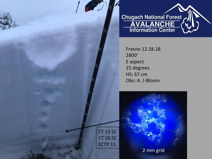
Many riding areas on the Chugach National Forest opened yesterday. Please check the riding area status below for the most up-to-date information. The avalanche center would love to know what you are seeing out riding. See any recent avalanches, shooting cracks or experience the snowpack collapsing??? Please send us an observation or tag us in a photo @chugachavy. Remember to always carry avalanche rescue gear and use stafe travel protocols: ride one at a time in avalanche terrain, park out of runout zones and avoid terrain traps.  

Wed, December 19th, 2018
Alpine
Above 2,500'
2 - Moderate
Avalanche risk
Treeline
1,000'-2,500'
2 - Moderate
Avalanche risk
Below Treeline
Below 1,000'
1 - Low
Avalanche risk
0 - No Rating
1 - Low
2 - Moderate
3 - Considerable
4 - High
5 - Extreme
Avalanche risk Avalanche risk Avalanche risk Avalanche risk Avalanche risk
Travel Advice Generally safe avalanche conditions. Watch for unstable snow on isolated terrain features. Heightened avalanche conditions on specific terrain features. Evaluate snow and terrain carefully; identify features of concern. Dangerous avalanche conditions. Careful snowpack evaluation, cautious route-finding, and conservative decision-making essential. Very dangerous avalanche conditions. Travel in avalanche terrain not recommended. Extraordinarily dangerous avalanche conditions. Avoid all avalanche terrain.
Likelihood of Avalanches Natural and human-triggered avalanches unlikely. Natural avalanches unlikely; human-triggered avalanches possible. Natural avalanches possible; human-triggered avalanches likely. Natural avalanches likely; human-triggered avalanches very likely. Natural and human-triggered avalanches certain.
Avalanche Size and Distribution Small avalanches in isolated areas or extreme terrain. Small avalanches in specific areas; or large avalanches in isolated areas. Small avalanches in many areas; or large avalanches in specific areas; or very large avalanches in isolated areas. Large avalanches in many areas; or very large avalanches in specific areas. Very large avalanches in many areas.
Avalanche Problem 1
  • Wind Slabs
    Wind Slabs
  • Certain
    Very Likely
    Likely
    Possible
    Unlikely
    Likelihood
  • Historic (D4-5)
    Very Large (D3)
    Large (D2)
    Small (D1)
    Size
Wind Slabs
Wind Slab avalanches are the release of a cohesive layer of snow (a slab) formed by the wind. Wind typically transports snow from the upwind sides of terrain features and deposits snow on the downwind side. Wind slabs are often smooth and rounded and sometimes sound hollow, and can range from soft to hard. Wind slabs that form over a persistent weak layer (surface hoar, depth hoar, or near-surface facets) may be termed Persistent Slabs or may develop into Persistent Slabs.

Likelihood of Avalanches
Terms such as "unlikely", "likely", and "certain" are used to define the scale, with the chance of triggering or observing avalanches increasing as we move up the scale. For our purposes, "Unlikely" means that few avalanches could be triggered in avalanche terrain and natural avalanches are not expected. "Certain" means that humans will be able to trigger avalanches on many slopes, and natural avalanches are expected.

Size of Avalanches
Avalanche size is defined by the largest potential avalanche, or expected range of sizes related to the problem in question. Assigned size is a qualitative estimate based on the destructive classification system and requires specialists to estimate the harm avalanches may cause to hypothetical objects located in the avalanche track (AAA 2016, CAA 2014). Under this schema, "Small" avalanches are not large enough to bury humans and are relatively harmless unless they carry people over cliffs or through trees or rocks. Moving up the scale, avalanches become "Large" enough to bury, injure, or kill people. "Very Large" avalanches may bury or destroy vehicles or houses, and "Historic" avalanches are massive events capable of altering the landscape.

Signal Word Size (D scale) Simple Descriptor
Small 1 Unlikely to bury a person
Large 2 Can bury a person
Very Large 3 Can destroy a house
Historic 4 & 5 Can destroy part or all of a village
More info at Avalanche.org

There is a lot of snow available for transport and the winds bumped up early this morning, blowing from the east 20 mph gusting into the 40s on Sunburst. Maxs Mountain weather station saw gusts into the 50s.  Look for tender wind slabs along ridgelines, especially on unsupported slopes. Girdwood Valley picked up another 5″ of snow in the last 24 hrs and Turnagain Pass an additional 3″. Since the storm on Sunday avalanche activity has been relegated to small pockets of storm slab, soft wind slab and loose snow sluffs. Today it will be important to watch for stiffer snow over softer snow, cracking and whumpfing (collapsing). Due to more snow in the Girdwood Valley wind slabs could be thicker. As always think about the consequences of even a small slab in steep terrain. As more snow falls today storm slabs may form quickly and be reactive. 

Loose snow avalanches: In areas protected from the winds watch your sluff. Sluffs could start getting larger with the cooler temperatures and the quantity of soft snow. 

Sunburst weather station’s bump in winds this morning. 12-19-18

Remember there is a lot of snow available for transport! New snow that fell Sunday in Girdwood. 12-16-18. Photo: Andy Moderow


Avalanche Problem 2
  • Persistent Slabs
    Persistent Slabs
  • Certain
    Very Likely
    Likely
    Possible
    Unlikely
    Likelihood
  • Historic (D4-5)
    Very Large (D3)
    Large (D2)
    Small (D1)
    Size
Persistent Slabs
Persistent Slab avalanches are the release of a cohesive layer of snow (a slab) in the middle to upper snowpack, when the bond to an underlying persistent weak layer breaks. Persistent layers include: surface hoar, depth hoar, near-surface facets, or faceted snow. Persistent weak layers can continue to produce avalanches for days, weeks or even months, making them especially dangerous and tricky. As additional snow and wind events build a thicker slab on top of the persistent weak layer, this avalanche problem may develop into a Deep Persistent Slab.

Likelihood of Avalanches
Terms such as "unlikely", "likely", and "certain" are used to define the scale, with the chance of triggering or observing avalanches increasing as we move up the scale. For our purposes, "Unlikely" means that few avalanches could be triggered in avalanche terrain and natural avalanches are not expected. "Certain" means that humans will be able to trigger avalanches on many slopes, and natural avalanches are expected.

Size of Avalanches
Avalanche size is defined by the largest potential avalanche, or expected range of sizes related to the problem in question. Assigned size is a qualitative estimate based on the destructive classification system and requires specialists to estimate the harm avalanches may cause to hypothetical objects located in the avalanche track (AAA 2016, CAA 2014). Under this schema, "Small" avalanches are not large enough to bury humans and are relatively harmless unless they carry people over cliffs or through trees or rocks. Moving up the scale, avalanches become "Large" enough to bury, injure, or kill people. "Very Large" avalanches may bury or destroy vehicles or houses, and "Historic" avalanches are massive events capable of altering the landscape.

Signal Word Size (D scale) Simple Descriptor
Small 1 Unlikely to bury a person
Large 2 Can bury a person
Very Large 3 Can destroy a house
Historic 4 & 5 Can destroy part or all of a village
More info at Avalanche.org

As we have been mentioning for a while now, in thinner snowpack zones such as Summit Lake and Crow Pass, we are tracking buried layers of facets, crusts and buried surface hoar that sit 1-3′ under the snow surface. These layers are most prevalent in the mid-elevations (2000’ – 2700’). A lack of avalanche activity has been pointing to an unlikely chance for an avalanche releasing in these deeper layers. However, Summit Lake has poor snowpack structure and stability tests still show the potential for an avalanche to release. Wind loading this morning will potentially stress these weak layers in upper elevation start zones.  As we push out into more and more terrain in areas that may have a thinner snowpack like Lynx Creek and Johnson Pass, we need to keep in mind the buried weak layers.  

Fresno snow pit with weak snow near the ground, 12-18-18

Additional Concern
  • Glide Avalanches
    Glide Avalanches
Glide Avalanches
Glide Avalanches are the release of the entire snow cover as a result of gliding over the ground. Glide avalanches can be composed of wet, moist, or almost entirely dry snow. They typically occur in very specific paths, where the slope is steep enough and the ground surface is relatively smooth. They are often proceeded by full depth cracks (glide cracks), though the time between the appearance of a crack and an avalanche can vary between seconds and months. Glide avalanches are unlikely to be triggered by a person, are nearly impossible to forecast, and thus pose a hazard that is extremely difficult to manage.
More info at Avalanche.org

We have had several reports that the glide cracks are opening. Glide cracks we know about are on Sunburst’s SW face under the weather stationSW face of Tincan Proper, Gold Pan area (behind Cornbiscuit/Magnum) and a crack that did release in the Johnson Pass area. These cracks can release at any moment. They are not associated with human triggers and the best way to manage the hazard is to avoid being on or beneath slopes with cracks. 

Weather
Wed, December 19th, 2018

Yesterday:  Sky cover fluctuated between overcast and obscure. Light snow fell on and off throughout the day. Winds were light and easterly and temperatures were in the teens and 20Fs. Overnight snow showers continued. Temperatures stayed in the teens and 20Fs and winds were calm.

Today:  At 4 am this morning easterly winds picked up blowing 20 mph and gusting as high as 56 mph on Maxs Mountain weather station. Today winds are forecast to be 10-20 mph with gusts into the 40s. Temperatures will be in the 20Fs and light snow is forecast to continue falling, 1-6″.   Winds decrease overnight and temperatures will be in the teens with clouds clearing out.    

Tomorrow:  Thursday is forecast to be mostly sunny. Temperatures will be in the teens and winds will be light. Overnight temperatures will drop into the single digits. This cold and clear pattern looks to last into Saturday. Stay tuned for next low moving into the Gulf Saturday night.  

*Seattle Ridge anemometer (wind sensor) is rimed over and not reporting. Temperature data went down at 1:00 pm yesterday.  

PRECIPITATION 24-hour data (6am – 6am)

  Temp Avg (F) Snow (in) Water (in) Snow Depth (in)
Center Ridge (1880′) 20     3   0.2   39    
Summit Lake (1400′) 20      1   0.1   14    
Alyeska Mid (1700′)

20    

 5   0.4   31  

RIDGETOP 24-hour data (6am – 6am)

  Temp Avg (F) Wind Dir Wind Avg (mph) Wind Gust (mph)
Sunburst (3812′) 17   NE    3  45
Seattle Ridge (2400′) *18   *no data   *no data      *no data  
Observations
Recent Observations for Turnagain Pass
Date Region Location
04/16/24 Turnagain Observation: Cornbiscuit
04/15/24 Turnagain Observation: Taylor Pass
04/15/24 Turnagain Observation: Seward Highway – Tern Lake to Portage
04/14/24 Turnagain Observation: Sunburst
04/14/24 Turnagain Observation: Turnagain Pass Snomo
04/13/24 Turnagain Observation: Spokane Creek
04/11/24 Turnagain Observation: Tincan
04/10/24 Turnagain Avalanche: Seattle Ridge
04/10/24 Turnagain Observation: Cornbiscuit South Face
04/10/24 Turnagain Avalanche: Tincan
Riding Areas

The riding areas page has moved. Please click here & update your bookmarks.


Subscribe to Turnagain Pass
Avalanche Forecast by Email

This is a general backcountry avalanche advisory issued for Turnagain Arm with Turnagain Pass as the core advisory area. This advisory does not apply to highways, railroads or operating ski areas.