Turnagain Pass Avalanche Forecast
|
![]() ![]() |
The avalanche danger is MODERATE above 1,000′. Soft slab avalanches composed of Sunday’s storm snow will be possible to trigger on slopes steeper than 35 degrees. These are most likely to be shallow, 6 to 12″ thick, and found near ridgelines and over rollovers. Additional concerns: watch your sluff in steep terrain and avoid traveling underneath glide cracks.
SUMMIT LAKE: There are more developed weak layers near the ground; increasing the chance a person could trigger a larger slab avalanche. Choose terrain carefully.
TONIGHT, 6:30 pm: Avalanche Stories from Sunburst at Powder Hound Ski Shop, Girdwood €“ FREE. Join Chugach National Forest Avalanche Forecaster, Heather Thamm, for an evening discussion on avalanche safety and awareness. This talk will cover some basic things you need to know before going into the backcountry. Expect to hear lessons learned and stories from Sunburst in Turnagain Pass. This talk is geared towards any level of backcountry experience, novice to the seasoned Powder Hound.
Signal Word | Size (D scale) | Simple Descriptor |
Small | 1 | Unlikely to bury a person |
Large | 2 | Can bury a person |
Very Large | 3 | Can destroy a house |
Historic | 4 & 5 | Can destroy part or all of a village |
Snowfall over the past several days continues to deepen our early winter snowpack and provide some excellent surface conditions. Girdwood Valley has been the most favored for snowfall and has seen over a foot in the past 48 hours, while Turnagain Pass has seen 6-10″. The Summit Lake zone has seen roughly 6-8″. Very little wind effect during this time has been observed and avalanche activity has been relegated to small pockets of storm slab, soft wind slab and loose snow sluffs. For today, another 1 to 3″ of light snow is forecast and will add to these ‘surface instabilities’.
If skies open enough for travel to the upper elevations today, keep an eye on the surface conditions. Watch for stiffer snow over softer snow, cracking in the snow and whumpfing (collapsing). The Girdwood Valley could harbor some foot thick pockets of storm slab or wind slab due to the higher recent snowfall amounts. Also, watch your sluff. Sluffs should start getting larger with the cooler temperatures.
A small storm/wind slab pocket was triggered yesterday in Tincan’s Common Bowl. Thank you to Drew Petrie for sending in his photo.
As we have been mentioning for a while now, in thinner snowpack zones such as Summit Lake and Crow Pass, we are tracking buried layers of facets, crusts and buried surface hoar that sit 1-3′ under the snow surface. These layers are most prevalent in the mid-elevations (2000’ – 2700’). Snow pit data and a lack of avalanche activity has been pointing to an unlikely chance for an avalanche releasing in these deeper layers. However, as we push out into more and more terrain, we need to keep in mind the snowpack could have some surprises lurking.
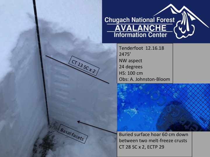
Snow pit on Tenderfoot, in the Summit Lake area, from Sunday shows buried surface hoar deep 2′ below the surface that will react with a lot of force.
Glide cracks are moving. We have had several reports that cracks are opening. Glide cracks we know about are on Sunburst’s SW face under the weather station, SW face of Tincan Proper, Gold Pan area (behind Cornbiscuit/Magnum) and a crack that did release in the Johnson Pass area. These cracks can release at any moment. They are not associated with human triggers and the best way to manage the hazard is to avoid being on or beneath slopes with cracks.
Yesterday: Partly cloudy skies with some valley fog were over the region. Intermittent flurries overnight has added a trace to an inch of snow at Turnagain Pass and 1-2″ of snow in the Girdwood Valley. Ridgetop winds were easterly yesterday, 5-10mph, and have been light and variable overnight. Temperatures remain near 20F along ridgelines and the upper 20’sF at sea level.
Today: Mostly cloudy skies with a chance for 1 to 3″ of cold, low-density snow are on tap today. Ridgetop winds should be northerly in the 5-10mph range. Temperatures will remain winter-like, in the 20’sF at sea level and in the teens along ridgelines. Tonight, we may see a bump in snowfall rates with another 2-4″ of low-density snow possible with this light northerly flow.
Tomorrow: Light snow showers should cover the region Wednesday. Models are showing a low-pressure forming just south of Seward that looks to shift winds back to the east and pump in a bit of moisture. Snow numbers for tomorrow look to be in the 3-6″ range.
*Seattle Ridge anemometer (wind sensor) is rimed over and not reporting.
Temp Avg (F) | Snow (in) | Water (in) | Snow Depth (in) | |
Center Ridge (1880′) | 21 | trace | 0 | 36 |
Summit Lake (1400′) | 20 | 0 | 0 | 15 |
Alyeska Mid (1700′) | 21 | 1-2″ | .1 – .2 | 27 |
Temp Avg (F) | Wind Dir | Wind Avg (mph) | Wind Gust (mph) | |
Sunburst (3812′) | 19 | E | 5 | 21 |
Seattle Ridge (2400′) | 20 | *no data | *no data | *no data |
Date | Region | Location | Observer |
---|---|---|---|
05/22/23 | Turnagain | Avalanche: Tincan | Nick D'Alessio |
05/12/23 | Turnagain | Avalanche: Tincan, Sunburst, Magnum, Cornbiscuit | Heather Thamm |
05/07/23 | Turnagain | Observation: Tincan – Bear Tracks | CNFAIC Staff |
05/05/23 | Turnagain | Observation: Seattle Ridge | AS/ WW Forecaster |
05/02/23 | Turnagain | Observation: Cornbiscuit | Schauer/ Sturgess Forecaster |
05/02/23 | Turnagain | Observation: Seward Hwy Turnagain Pass | Joel Curtis |
04/30/23 | Turnagain | Observation: Magnum | Ayla, Kit Crosby, Barton |
04/29/23 | Turnagain | Observation: Tincan | John Sykes |
04/28/23 | Turnagain | Avalanche: Taylor Pass/Pastoral | Schauer/ Creighton Forecaster |
04/28/23 | Turnagain | Avalanche: Tincan | Andy Moderow |
Status of riding areas across the Chugach NF is managed by the Glacier and Seward Ranger Districts, not avalanche center staff. Riding area information is posted as a public service to our users and updated based on snow depth and snow density to prevent resource damage at trailhead locations. Riding area questions contact: mailroom_r10_chugach@fs.fed.us
Area | Status | Weather & Riding Conditions |
---|---|---|
Glacier District |
Subscribe to Turnagain Pass
Avalanche Forecast by Email
This is a general backcountry avalanche advisory issued for Turnagain Arm with Turnagain Pass as the core advisory area. This advisory does not apply to highways, railroads or operating ski areas.