Turnagain Pass Avalanche Forecast
|
![]() ![]() |
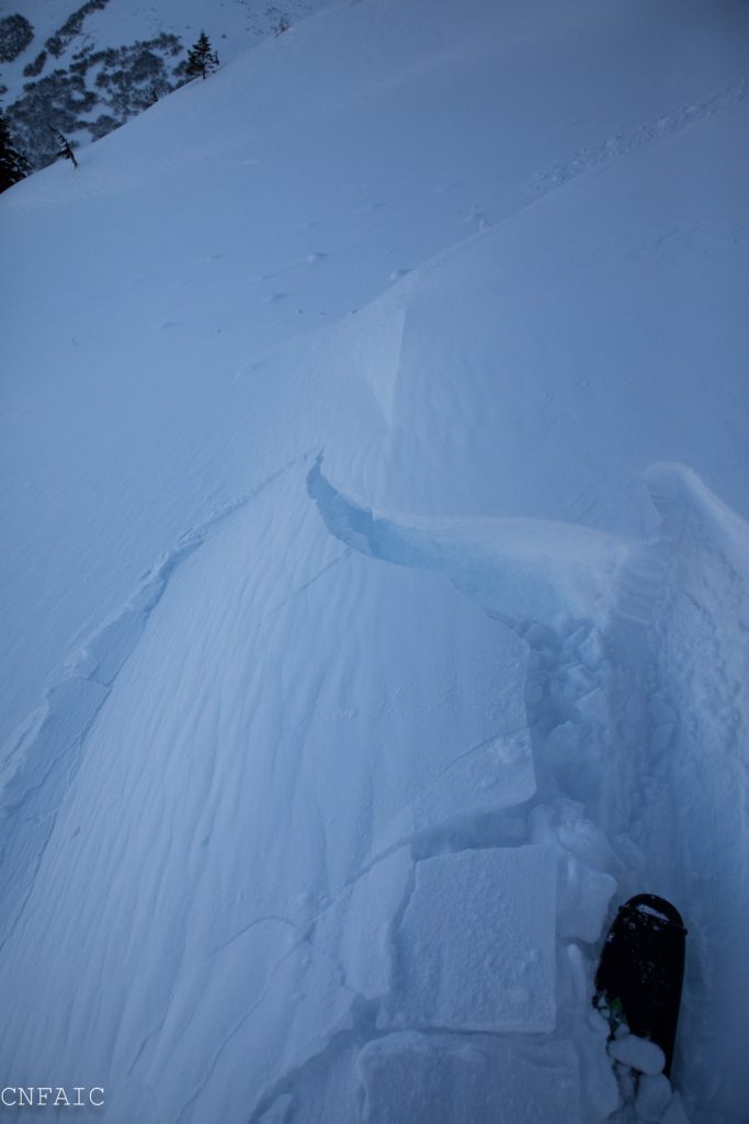
The avalanche danger is MODERATE in the Alpine and at Treeline where triggering a slab 1-3′ deep is possible in a shallow areas of the snowpack. In the Alpine triggering an isolated windslab or getting caught up in a loose snow avalanche is possible in steep terrain. Avoid traveling underneath glide cracks.
Assess the snowpack as you travel, identify areas of concern and evaluate consequences.
If you are heading to Hatcher Pass make sure to read a recent report from Hatch Peak on Sunday where a skier was fully buried and recovered without injury. Be aware alaskasnow.org is undergoing a system-wide website update and Hatcher Pass Avalanche Center webpage may look very different when it is finished. For now stay current by following the new Hatcher Pass Avalanche Center mid-week update HERE.
Looking for avalanche courses or evening presentations? Check out our calendar page!
Signal Word | Size (D scale) | Simple Descriptor |
Small | 1 | Unlikely to bury a person |
Large | 2 | Can bury a person |
Very Large | 3 | Can destroy a house |
Historic | 4 & 5 | Can destroy part or all of a village |
Overnight ridgetop winds have picked up into the teens with some gust in the 20’s mph. In the alpine there’s over a foot of low-density snow available for transport and another 3-6” of new snow in the forecast today. Triggering an isolated windslab on leeward or cross-loaded features will be possible, especially if you see blowing snow. Otherwise mild weather and cold temps have been keeping all this new snow as light dry powder. Should you go into steep terrain, pay attention to how much new snow is falling and if winds are moving it around. Shooting cracks will be an obvious clue windslabs are tender. Feel for punchy or upside down snow and keep in mind the consequences of the terrain should even a small rug get pulled out from underneath you. In areas where winds aren’t an issue loose surface snow could move faster and farther than expected.
Shooting crack on a wind loaded terrain feature on a NW aspect of Tenderfoot yesterday at 2500′.
Some larger fast moving point release sluffs were observed yesterday in steep terrain on Sunburst.
Signal Word | Size (D scale) | Simple Descriptor |
Small | 1 | Unlikely to bury a person |
Large | 2 | Can bury a person |
Very Large | 3 | Can destroy a house |
Historic | 4 & 5 | Can destroy part or all of a village |
No new avalanche activity has been reported in our forecast zone since a wet and windy storm ended last weekend. Yesterday dozens of tracks could be seen in steep terrain which is a good sign of increasing stability. With that said there remains some uncertainty around weak snow within older layers of the snowpack, especially in Summit Lake, in Crow Creek Valley and the Southern end of Turnagain Pass where a thinner snowpack exists. The mid-elevation band is also more suspect where the snow quickly transitions to shallower depths. Observations this week have found a facet/crust combo 1-2’ below the surface in the mid-elevations (2000’ – 2700’.) Whumpfing and reactive stability tests were observed on Tuesday on Magnum’s NW shoulder. Rotten faceted snow near the ground in Summit Lake is also a concern especially with more snow expected over the weekend. Evaluated the snowpack and terrain as you travel and be aware that obvious clues like whumpfing or recent avalanche may not be present.
Snowpit on Tenderfoot shows a thinner snowpack where weak snow is sitting on the ground.
The first glide cracks of the season were seen on Sunburst SW face under the weather station and another on the SW face of Tincan Proper. A glide crack is the snowpack being pulled by gravity downhill along the ground. They can release at any moment without warning and are usually not associated with human triggers. The best way to manage this hazard is to avoid being on or beneath any slopes with cracks opening up.
Yesterday: Skies were clear and sunny. Temperatures were in the single digits (F) in the upper elevations and teens (F) near 1000′. Winds were light and picked up in the evening from the East 10-15mph with gusts in the 20s mph. An inch of new snow fell in Turnagain Pass overnight and a trace in Girdwood.
Today: Temperatures will gradually increase throughout the day into the mid-20’s at 1000′. Snow showers will start this afternoon with 3-6 € of snow possible and another 4-5 € overnight. East ridgetop winds are expected to be 10-15mph and build into the 20’s mph overnight.
Tomorrow: Temperatures will continue to increase into the mid-30’s (F) at sea level. Rain/snowline may be around 500′. Another storm is expected Saturday evening through Sunday morning. An active weather pattern is expected to persist into early next week.
*Seattle Ridge weather station anemometer has been rimed and not recording wind data.
Temp Avg (F) | Snow (in) | Water (in) | Snow Depth (in) | |
Center Ridge (1880′) | 13 | 1 | 0.1 | 31 |
Summit Lake (1400′) | 7 | 0 | 0 | 9 |
Alyeska Mid (1700′) | 14 | trace | 0.07 | 17 |
Temp Avg (F) | Wind Dir | Wind Avg (mph) | Wind Gust (mph) | |
Sunburst (3812′) | 4 | ENE | 7 | 31 |
Seattle Ridge (2400′) | 12 | *NA | *NA | *NA |
Date | Region | Location | Observer |
---|---|---|---|
05/22/23 | Turnagain | Avalanche: Tincan | Nick D'Alessio |
05/12/23 | Turnagain | Avalanche: Tincan, Sunburst, Magnum, Cornbiscuit | Heather Thamm |
05/07/23 | Turnagain | Observation: Tincan – Bear Tracks | CNFAIC Staff |
05/05/23 | Turnagain | Observation: Seattle Ridge | AS/ WW Forecaster |
05/02/23 | Turnagain | Observation: Cornbiscuit | Schauer/ Sturgess Forecaster |
05/02/23 | Turnagain | Observation: Seward Hwy Turnagain Pass | Joel Curtis |
04/30/23 | Turnagain | Observation: Magnum | Ayla, Kit Crosby, Barton |
04/29/23 | Turnagain | Observation: Tincan | John Sykes |
04/28/23 | Turnagain | Avalanche: Taylor Pass/Pastoral | Schauer/ Creighton Forecaster |
04/28/23 | Turnagain | Avalanche: Tincan | Andy Moderow |
Status of riding areas across the Chugach NF is managed by the Glacier and Seward Ranger Districts, not avalanche center staff. Riding area information is posted as a public service to our users and updated based on snow depth and snow density to prevent resource damage at trailhead locations. Riding area questions contact: mailroom_r10_chugach@fs.fed.us
Area | Status | Weather & Riding Conditions |
---|---|---|
Glacier District |
Subscribe to Turnagain Pass
Avalanche Forecast by Email
This is a general backcountry avalanche advisory issued for Turnagain Arm with Turnagain Pass as the core advisory area. This advisory does not apply to highways, railroads or operating ski areas.