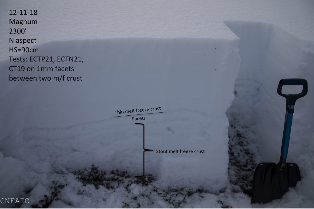
Turnagain Pass RSS

Archives
ARCHIVED - Forecasts expire after 24 hours.
Issued
Thu, December 13th, 2018 - 7:00AM
Expires
Fri, December 14th, 2018 - 7:00AM
Forecaster
Heather Thamm
Avalanche risk The Bottom Line

The avalanche danger is  MODERATE  in the Alpine and at Treeline where triggering a slab 1-3′ deep is possible. Triggering a windslab or getting caught up in a loose snow avalanche will be possible in steep terrain. Keep an eye out for glide cracks and avoid traveling underneath this unpredictable avalanche hazard.

Assess the snowpack as you travel, identify areas of concern and evaluate consequences.

GIRDWOOD:  Windslab 1-2′ thick are possible on leeward features in the alpine due to higher snow totals and elevated ridgetops winds yesterday.

Special Announcements

If you are heading to Hatcher Pass  make sure  to read a recent report from  Hatch Peak on Sunday where a skier was fully buried and recovered without injury.   Be aware alaskasnow.org is undergoing a system-wide website update and  Hatcher Pass Avalanche Center  webpage may look very different when it is finished. For now stay current by following the new Hatcher Pass Avalanche Center mid-week update HERE.  

Looking for avalanche courses or evening presentations? Check out our  calendar page! There are two CNFAIC evening discussions coming up – these are FREE and a great way to get your head back in the avalanche game. TONIGHT 7pm-8:30pm –  ‘Tales from the Pit’ at Blue & Gold Boardshop in Anchorage!

Thu, December 13th, 2018
Alpine
Above 2,500'
2 - Moderate
Avalanche risk
Treeline
1,000'-2,500'
2 - Moderate
Avalanche risk
Below Treeline
Below 1,000'
1 - Low
Avalanche risk
0 - No Rating
1 - Low
2 - Moderate
3 - Considerable
4 - High
5 - Extreme
Avalanche risk Avalanche risk Avalanche risk Avalanche risk Avalanche risk
Travel Advice Generally safe avalanche conditions. Watch for unstable snow on isolated terrain features. Heightened avalanche conditions on specific terrain features. Evaluate snow and terrain carefully; identify features of concern. Dangerous avalanche conditions. Careful snowpack evaluation, cautious route-finding, and conservative decision-making essential. Very dangerous avalanche conditions. Travel in avalanche terrain not recommended. Extraordinarily dangerous avalanche conditions. Avoid all avalanche terrain.
Likelihood of Avalanches Natural and human-triggered avalanches unlikely. Natural avalanches unlikely; human-triggered avalanches possible. Natural avalanches possible; human-triggered avalanches likely. Natural avalanches likely; human-triggered avalanches very likely. Natural and human-triggered avalanches certain.
Avalanche Size and Distribution Small avalanches in isolated areas or extreme terrain. Small avalanches in specific areas; or large avalanches in isolated areas. Small avalanches in many areas; or large avalanches in specific areas; or very large avalanches in isolated areas. Large avalanches in many areas; or very large avalanches in specific areas. Very large avalanches in many areas.
Avalanche Problem 1
  • Wind Slabs
    Wind Slabs
  • Certain
    Very Likely
    Likely
    Possible
    Unlikely
    Likelihood
  • Historic (D4-5)
    Very Large (D3)
    Large (D2)
    Small (D1)
    Size
Wind Slabs
Wind Slab avalanches are the release of a cohesive layer of snow (a slab) formed by the wind. Wind typically transports snow from the upwind sides of terrain features and deposits snow on the downwind side. Wind slabs are often smooth and rounded and sometimes sound hollow, and can range from soft to hard. Wind slabs that form over a persistent weak layer (surface hoar, depth hoar, or near-surface facets) may be termed Persistent Slabs or may develop into Persistent Slabs.

Likelihood of Avalanches
Terms such as "unlikely", "likely", and "certain" are used to define the scale, with the chance of triggering or observing avalanches increasing as we move up the scale. For our purposes, "Unlikely" means that few avalanches could be triggered in avalanche terrain and natural avalanches are not expected. "Certain" means that humans will be able to trigger avalanches on many slopes, and natural avalanches are expected.

Size of Avalanches
Avalanche size is defined by the largest potential avalanche, or expected range of sizes related to the problem in question. Assigned size is a qualitative estimate based on the destructive classification system and requires specialists to estimate the harm avalanches may cause to hypothetical objects located in the avalanche track (AAA 2016, CAA 2014). Under this schema, "Small" avalanches are not large enough to bury humans and are relatively harmless unless they carry people over cliffs or through trees or rocks. Moving up the scale, avalanches become "Large" enough to bury, injure, or kill people. "Very Large" avalanches may bury or destroy vehicles or houses, and "Historic" avalanches are massive events capable of altering the landscape.

Signal Word Size (D scale) Simple Descriptor
Small 1 Unlikely to bury a person
Large 2 Can bury a person
Very Large 3 Can destroy a house
Historic 4 & 5 Can destroy part or all of a village
More info at Avalanche.org

Yesterday morning an unexpected sleeper storm was centered over Girdwood and dumped 6-12” of very low-density snow. Snow totals were greater in the alpine. Turnagain Pass received 3” along the road and up to 10” at higher elevations. Winds in the afternoon along ridgetops picked up for a few hours 10-15mph with some gusts in the 20s-40s mph. Triggering an isolated windslab on leeward and cross-loaded features will be possible. Look for smooth or pillow shaped features. Evaluate the snow and terrain as you travel and keep in mind the consequences should even a small rug get pulled out from underneath you.

In areas where winds didn’t change the surface expect new snow to be loose and unconsolidated. Don’t be surprised by ‘sluffing’ and loose snow moving faster than expected.

Low density loose snow was sluffing easily on steeper features yesterday at Tincan. Photo credit: Tully LaBelle-Hamer

Avalanche Problem 2
  • Persistent Slabs
    Persistent Slabs
  • Certain
    Very Likely
    Likely
    Possible
    Unlikely
    Likelihood
  • Historic (D4-5)
    Very Large (D3)
    Large (D2)
    Small (D1)
    Size
Persistent Slabs
Persistent Slab avalanches are the release of a cohesive layer of snow (a slab) in the middle to upper snowpack, when the bond to an underlying persistent weak layer breaks. Persistent layers include: surface hoar, depth hoar, near-surface facets, or faceted snow. Persistent weak layers can continue to produce avalanches for days, weeks or even months, making them especially dangerous and tricky. As additional snow and wind events build a thicker slab on top of the persistent weak layer, this avalanche problem may develop into a Deep Persistent Slab.

Likelihood of Avalanches
Terms such as "unlikely", "likely", and "certain" are used to define the scale, with the chance of triggering or observing avalanches increasing as we move up the scale. For our purposes, "Unlikely" means that few avalanches could be triggered in avalanche terrain and natural avalanches are not expected. "Certain" means that humans will be able to trigger avalanches on many slopes, and natural avalanches are expected.

Size of Avalanches
Avalanche size is defined by the largest potential avalanche, or expected range of sizes related to the problem in question. Assigned size is a qualitative estimate based on the destructive classification system and requires specialists to estimate the harm avalanches may cause to hypothetical objects located in the avalanche track (AAA 2016, CAA 2014). Under this schema, "Small" avalanches are not large enough to bury humans and are relatively harmless unless they carry people over cliffs or through trees or rocks. Moving up the scale, avalanches become "Large" enough to bury, injure, or kill people. "Very Large" avalanches may bury or destroy vehicles or houses, and "Historic" avalanches are massive events capable of altering the landscape.

Signal Word Size (D scale) Simple Descriptor
Small 1 Unlikely to bury a person
Large 2 Can bury a person
Very Large 3 Can destroy a house
Historic 4 & 5 Can destroy part or all of a village
More info at Avalanche.org

There remains some uncertainty around weak snow within older layers of the snowpack. Observations this week have found a facet/crust combo 1-2’ below the surface in the mid-elevations (2000’ – 2700’.) Large collapses “whumpfs” were experienced on Magnum’s NW shoulder on Tuesday and stability tests were quite reactive in this zone. It’s unknown how intact this structure exists into the Alpine. On the Northern end of Turnagain Pass stability tests have been showing a strengthening snowpack at higher elevations. However keep in mind that we’ve seen a lot of snow over the last week and we don’t have a lot of snowpack info. It’s still early season. Areas with a thinner snowpack are more suspect for weaker and unstable snow including the Southern-end of Turnagain Pass, Summit Lake and Girdwood Valley. In general North and East aspects have a tendency to be thinner and there is a zone in the mid-elevations where the snowpack quickly transitions to shallower depths. 

Be on the lookout for red flag warnings like whumpfing’, shooting cracks, new avalanche activity or any changes in weather. Keep in mind there is a lot of snow available for transport. Any sign of increased winds could form reactive wind slabs or add stress to a persistent slab.

This is a good example of where the snow quickly transitions shallow and weaker snowpack in the mid elevations. This structure may be more widespread on the Southern end of Turnagain Pass and in Summit Lake. 

Additional Concern
  • Glide Avalanches
    Glide Avalanches
Glide Avalanches
Glide Avalanches are the release of the entire snow cover as a result of gliding over the ground. Glide avalanches can be composed of wet, moist, or almost entirely dry snow. They typically occur in very specific paths, where the slope is steep enough and the ground surface is relatively smooth. They are often proceeded by full depth cracks (glide cracks), though the time between the appearance of a crack and an avalanche can vary between seconds and months. Glide avalanches are unlikely to be triggered by a person, are nearly impossible to forecast, and thus pose a hazard that is extremely difficult to manage.
More info at Avalanche.org

The first glide cracks of the season were seen on Sunburst SW face under the weather station. A glide crack is the snowpack being pulled by gravity downhill along the ground. They can release at any moment without warning and are usually not associated with human triggers. The best way to manage this hazard is to avoid being on or beneath any slopes with cracks opening up. 

Photo taken on Tues December 11, 2018 of new glide cracks on SW face of Sunburst

Weather
Thu, December 13th, 2018

Yesterday: Snow flurries were the most intense in the morning between 6am to 10am. Turnagain received 3 € of low-density snow along the road and Girdwood 6-10 € at valley bottom. Winds were light with the exception of a few hours along ridgetops where winds increased to 10-15mph with gusts in the 20-40s. Temps at sea level were in the low 20Fs and ridgetops dropped into the single digits.

Today:  Temps will be similar with single digits at ridgetops and low-20Fs near sea level. Snow flurries will diminish becoming mostly sunny in the afternoon. Winds are expected to be light (5-10mph) from the West and shift to the East by this evening. Tonight snow flurries will return with a few inches possible overnight.

Tomorrow: An active winter weather pattern will persist tomorrow and into the weekend. A continuation of more snow showers, cool temps and light to moderate winds is expected.

*Seattle Ridge weather station anemometer is rimed and not recording wind data.    

PRECIPITATION 24-hour data (6am – 6am)

  Temp Avg (F) Snow (in) Water (in) Snow Depth (in)
Center Ridge (1880′) 18   4   0.1 33  
Summit Lake (1400′) 15   3   0.3   10  
Alyeska Mid (1700′) 17   7   0.11   20  

RIDGETOP 24-hour data (6am – 6am)

  Temp Avg (F) Wind Dir Wind Avg (mph) Wind Gust (mph)
Sunburst (3812′) 8   ENE   5   30  
Seattle Ridge (2400′) 14   *N/A   *N/A   *N/A  
Observations
Recent Observations for Turnagain Pass
Date Region Location
03/18/24 Turnagain Observation: Tincan
03/16/24 Turnagain Observation: Seattle Ridge front side
03/16/24 Turnagain Observation: TinCan Backdoor/ Center Ridge/ Sunburst Backdoor
03/16/24 Turnagain Observation: Turnagain Front Side
03/15/24 Turnagain Avalanche: Main Bowl
03/14/24 Turnagain Avalanche: Tincan
03/14/24 Turnagain Avalanche: Sunburst South Face
03/14/24 Turnagain Avalanche: Tincan common
03/14/24 Turnagain Avalanche: Seattle Ridge – avalanches on the front and back side
03/13/24 Turnagain Observation: Turnagain Flats
Riding Areas

The riding areas page has moved. Please click here & update your bookmarks.


Subscribe to Turnagain Pass
Avalanche Forecast by Email

This is a general backcountry avalanche advisory issued for Turnagain Arm with Turnagain Pass as the core advisory area. This advisory does not apply to highways, railroads or operating ski areas.