Turnagain Pass Avalanche Forecast
|
![]() ![]() |
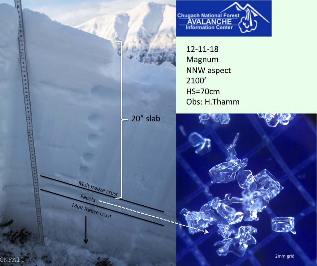
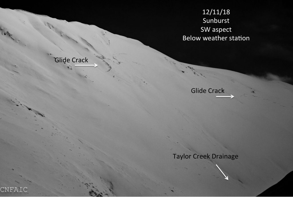
The avalanche danger is MODERATE in the Alpine and at Treeline where triggering a slab 1-3′ deep is possible. Keep an eye out for glide cracks and avoid traveling underneath this unpredictable avalanche hazard. Assess the snowpack as you travel, identify areas of concern and evaluate terrain consequences.
UPDATE: An unexpected sleeper storm is upon us!! We’ve seen 6-12″ in the Girdwood Valley and 3″ in Turnagain Pass between 6am and 10am. This is a very low density snow storm with little volume and little wind. Expect ‘sluffs’ in steep terrain and pay attention to new snow accumulation. In areas recieving a foot or more of snow the avalanche danger could increase to CONSIDERABLE.
Incremental loading over the last three days and more observations have nudged the mid-elevation band to MODERATE danger for triggering a slab 1-3’ thick releasing on weak snow. Yesterday on Magnum Mountain widespread ‘whumpfing’ caused a group to turn around at 2300’. A reactive layer of facets between two crusts showed easy propagation and they had low confidence in continuing into steeper terrain. This is a good reminder that it is still early season and limited snowpack observations exist across the forecast zone. Areas with a thinner snowpack are more suspect for weaker and unstable snow including the Southern-end of Turnagain Pass, Summit Lake and Girdwood Valley.
In the Alpine on the Northern end of Turnagain Pass stability tests have been showing a strengthening snowpack. However keep in mind North and East aspects have a tendency to be thinner and there is a zone in the mid-elevations where the snowpack quickly transitions to shallower depths.
As always be on the lookout for red flag warnings like ‘whumpfing’, shooting cracks, new avalanche activity and any changes in weather. Today a 1-3″ inches of snow is expected and there is currently 4-8” of loose snow available for transport. Should ridgetop winds increase above the forecasted 5-15mph, keep an eye out for active wind loading. Any sign of increased winds could form wind slabs or add stress to a persistent slab.
One of three pits between 2000′ and 2300′ on Magnum’s NW shoulder that showed poor structure and propagation potential in stability tests
Yesterday several glide cracks were noted on the Southwest face of Sunburst below the weather station. A glide crack is the snowpack being pulled by gravity downhill along the ground. They can release at any moment without warning and are usually not associated with human triggers. The best way to manage this hazard is to avoid being on or beneath any slopes with cracks opening up.
Yesterday: Snow showers ended yesterday morning and skies were partly cloudy. Temperatures fell throughout the day from the upper-20Fs into the low-20F’s. Overnight ridgetop temps have fallen into the teens F. Winds were light and variable.
Today: Light snow flurries started early this morning. A few inches of snow (1-3″) is possible today across our region at all elevations. Temperatures will remain in the low 20F’s at 1000′ and low-teens F near ridgetops. Light Westerly winds 5-10 mph are expected to increase 10-15mph later this evening.
Tomorrow: Temperature will remain in the low 20F’s to low teens. Partly sunny skies are in the forecast for tomorrow and light winds. Friday into Saturday looks like our next best chance for snow showers.
*Seattle Ridge weather station anemometer is rimed and not recording wind data.
Temp Avg (F) | Snow (in) | Water (in) | Snow Depth (in) | |
Center Ridge (1880′) | 25 | 0 | 0 | 29 |
Summit Lake (1400′) | 24 | 1 | 0.1 | 7 |
Alyeska Mid (1700′) | 25 | 2 | 0.16 | 13 |
Temp Avg (F) | Wind Dir | Wind Avg (mph) | Wind Gust (mph) | |
Sunburst (3812′) | 17 | variable | 2 | 8 |
Seattle Ridge (2400′) | 23 | *N/A | *N/A | *N/A |
Date | Region | Location | Observer |
---|---|---|---|
12/06/19 | Turnagain | Avalanche: Sunburst | Billy Finley |
12/04/19 | Turnagain | Observation: Sunburst | A.Johnston-Bloom/ W.Wagner/ R.Van Luit Forecaster |
12/03/19 | Turnagain | Observation: Hippy Bowl | Nick Langowski |
12/01/19 | Turnagain | Observation: Tincan, All elevations | Eric Roberts |
12/01/19 | Turnagain | Observation: Tincan | Andy Moderow |
11/30/19 | Turnagain | Observation: Tincan Treeline Plateau/ Common Bowl/ Ridge | Eric Roberts |
11/29/19 | Turnagain | Observation: Sunburst Ob #2 | Aleph Johnston-Bloom Forecaster |
11/29/19 | Turnagain | Observation: Sunburst Ob #1 | Aleph Johnston-Bloom Forecaster |
11/27/19 | Turnagain | Observation: Tincan | Aleph Johnston-Bloom Forecaster |
11/25/19 | Turnagain | Observation: Sunnyside | Graham Predeger Forecaster |
Status of riding areas across the Chugach NF is managed by the Glacier and Seward Ranger Districts, not avalanche center staff. Riding area information is posted as a public service to our users and updated based on snow depth and snow density to prevent resource damage at trailhead locations. Riding area questions contact: mailroom_r10_chugach@fs.fed.us
Area | Status | Weather & Riding Conditions |
---|---|---|
Glacier District |