Turnagain Pass RSS

Archives
ARCHIVED - Forecasts expire after 24 hours.
Issued
Fri, November 30th, 2018 - 7:00AM
Expires
Sat, December 1st, 2018 - 7:00AM
Forecaster
Heather Thamm
Avalanche risk The Bottom Line

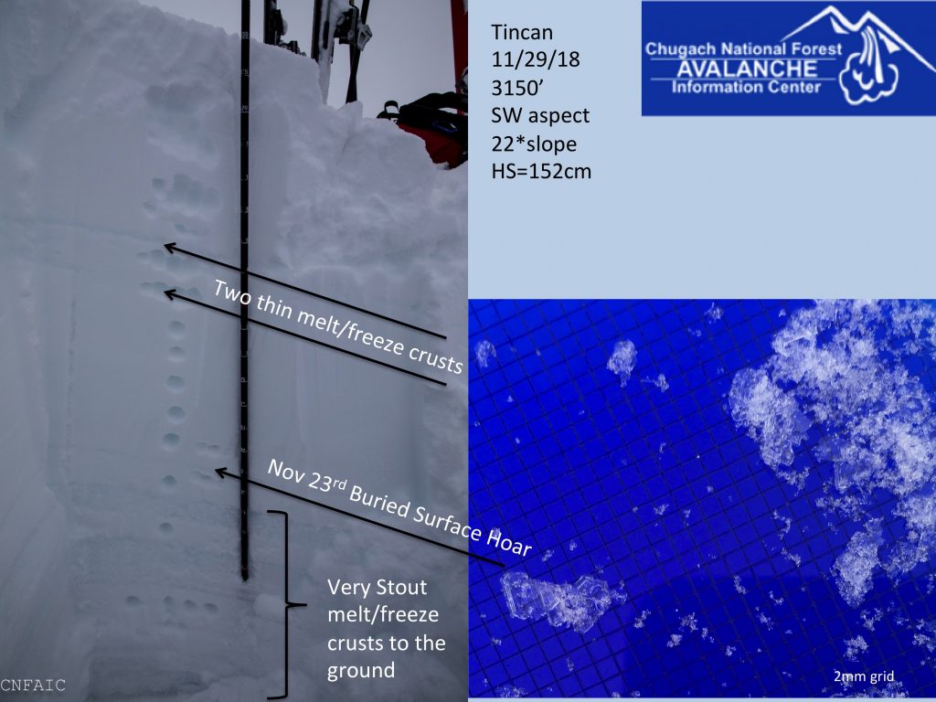
The avalanche danger is MODERATE above 2500′ where triggering a slab 1-3′ thick is possible on slopes steeper than 35 degrees. Be aware of changing weather and wind slabs forming late afternoon.

At treeline (below 2500′) the avalanche danger is LOW where a strong crust has formed and capped the snowpack.

Special Announcements

The Friends of the CNFAIC have two scholarships dedicated to avalanche education. The funds generated to make these possible are in celebration of Rob Hammel and Amy Downing, their love and passion for the mountains, and to help others stay safe. We encourage you to read each one and apply if you fit the need, or pass along to someone who could benefit.  Applications due on Dec 1st.

Rob Hammel Scholarship Fund   €“ For recreational users and professional avalanche workers.

Amy Downing Scholarship Fund   €“ For recreational users.

Fri, November 30th, 2018
Alpine
Above 2,500'
2 - Moderate
Avalanche risk
Treeline
1,000'-2,500'
1 - Low
Avalanche risk
Below Treeline
Below 1,000'
0 - No Rating
Avalanche risk
0 - No Rating
1 - Low
2 - Moderate
3 - Considerable
4 - High
5 - Extreme
Avalanche risk Avalanche risk Avalanche risk Avalanche risk Avalanche risk
Travel Advice Generally safe avalanche conditions. Watch for unstable snow on isolated terrain features. Heightened avalanche conditions on specific terrain features. Evaluate snow and terrain carefully; identify features of concern. Dangerous avalanche conditions. Careful snowpack evaluation, cautious route-finding, and conservative decision-making essential. Very dangerous avalanche conditions. Travel in avalanche terrain not recommended. Extraordinarily dangerous avalanche conditions. Avoid all avalanche terrain.
Likelihood of Avalanches Natural and human-triggered avalanches unlikely. Natural avalanches unlikely; human-triggered avalanches possible. Natural avalanches possible; human-triggered avalanches likely. Natural avalanches likely; human-triggered avalanches very likely. Natural and human-triggered avalanches certain.
Avalanche Size and Distribution Small avalanches in isolated areas or extreme terrain. Small avalanches in specific areas; or large avalanches in isolated areas. Small avalanches in many areas; or large avalanches in specific areas; or very large avalanches in isolated areas. Large avalanches in many areas; or very large avalanches in specific areas. Very large avalanches in many areas.
Avalanche Problem 1
  • Persistent Slabs
    Persistent Slabs
  • Certain
    Very Likely
    Likely
    Possible
    Unlikely
    Likelihood
  • Historic (D4-5)
    Very Large (D3)
    Large (D2)
    Small (D1)
    Size
Persistent Slabs
Persistent Slab avalanches are the release of a cohesive layer of snow (a slab) in the middle to upper snowpack, when the bond to an underlying persistent weak layer breaks. Persistent layers include: surface hoar, depth hoar, near-surface facets, or faceted snow. Persistent weak layers can continue to produce avalanches for days, weeks or even months, making them especially dangerous and tricky. As additional snow and wind events build a thicker slab on top of the persistent weak layer, this avalanche problem may develop into a Deep Persistent Slab.

Likelihood of Avalanches
Terms such as "unlikely", "likely", and "certain" are used to define the scale, with the chance of triggering or observing avalanches increasing as we move up the scale. For our purposes, "Unlikely" means that few avalanches could be triggered in avalanche terrain and natural avalanches are not expected. "Certain" means that humans will be able to trigger avalanches on many slopes, and natural avalanches are expected.

Size of Avalanches
Avalanche size is defined by the largest potential avalanche, or expected range of sizes related to the problem in question. Assigned size is a qualitative estimate based on the destructive classification system and requires specialists to estimate the harm avalanches may cause to hypothetical objects located in the avalanche track (AAA 2016, CAA 2014). Under this schema, "Small" avalanches are not large enough to bury humans and are relatively harmless unless they carry people over cliffs or through trees or rocks. Moving up the scale, avalanches become "Large" enough to bury, injure, or kill people. "Very Large" avalanches may bury or destroy vehicles or houses, and "Historic" avalanches are massive events capable of altering the landscape.

Signal Word Size (D scale) Simple Descriptor
Small 1 Unlikely to bury a person
Large 2 Can bury a person
Very Large 3 Can destroy a house
Historic 4 & 5 Can destroy part or all of a village
More info at Avalanche.org

In the alpine a thicker snowpack exists and with it more uncertainty.  Observers yesterday found depths to be in the 3-5’ range near 3000’. Two pit locations above 3000’ (on Tincan & Sunburst) found a layer of surface hoar buried 2-3’ below the surface. One party on Sunburst felt a collapse ‘whumpf’ around 2800’ along the West ridge and several large piles of debris were noted on steep Northern terrain from avalanches earlier in the week.

What does this all mean?

Triggering a large persistent slab is possible in steep terrain and will be more likely in thinner areas of the snowpack. It remains unknown how widespread this layer is across our region or how much avalanche activity occurred on it early in the storm that may be hidden. It may be more likely to trigger a persistent slab in places that received less overall precipitation like the Southern end of Turnagain Pass and Summit Lake. Persistent weak layers are tricky and hard to manage. Evaluate your consequences and choose conservative terrain. Be on the lookout for any obvious signs on instability like whumpfing, shooting cracks or any new avalanche activity.


Several snowpits dug in the upper elevations yesterday found buried surface hoar


Rollerballs and a small mid storm avalanche were visible yesterday. This visual is a little deceiving. Loose snow is covering a thin crust, but gradually disappears around 2700′. 


A strong crust has formed below 2500’ but the snowpack remains very thin to nonexistent below 1500′.

Avalanche Problem 2
  • Wind Slabs
    Wind Slabs
  • Certain
    Very Likely
    Likely
    Possible
    Unlikely
    Likelihood
  • Historic (D4-5)
    Very Large (D3)
    Large (D2)
    Small (D1)
    Size
Wind Slabs
Wind Slab avalanches are the release of a cohesive layer of snow (a slab) formed by the wind. Wind typically transports snow from the upwind sides of terrain features and deposits snow on the downwind side. Wind slabs are often smooth and rounded and sometimes sound hollow, and can range from soft to hard. Wind slabs that form over a persistent weak layer (surface hoar, depth hoar, or near-surface facets) may be termed Persistent Slabs or may develop into Persistent Slabs.

Likelihood of Avalanches
Terms such as "unlikely", "likely", and "certain" are used to define the scale, with the chance of triggering or observing avalanches increasing as we move up the scale. For our purposes, "Unlikely" means that few avalanches could be triggered in avalanche terrain and natural avalanches are not expected. "Certain" means that humans will be able to trigger avalanches on many slopes, and natural avalanches are expected.

Size of Avalanches
Avalanche size is defined by the largest potential avalanche, or expected range of sizes related to the problem in question. Assigned size is a qualitative estimate based on the destructive classification system and requires specialists to estimate the harm avalanches may cause to hypothetical objects located in the avalanche track (AAA 2016, CAA 2014). Under this schema, "Small" avalanches are not large enough to bury humans and are relatively harmless unless they carry people over cliffs or through trees or rocks. Moving up the scale, avalanches become "Large" enough to bury, injure, or kill people. "Very Large" avalanches may bury or destroy vehicles or houses, and "Historic" avalanches are massive events capable of altering the landscape.

Signal Word Size (D scale) Simple Descriptor
Small 1 Unlikely to bury a person
Large 2 Can bury a person
Very Large 3 Can destroy a house
Historic 4 & 5 Can destroy part or all of a village
More info at Avalanche.org

Easterly winds are expected to increase to Moderate (15-25mph) late afternoon and into the evening. In the alpine there is snow available for transport and triggering a shallow wind slab on leeward features may be possible. Pay close attention to changing weather and be on the lookout for shooting cracks and drifting snow.

Weather
Fri, November 30th, 2018

Yesterday: Temperatures remained below freezing with ridgetops near 15F most of the day and mid 20F’s near 1000′. Winds were light and variable. No measureable amount of precipitation fell.   Skies were broken in the morning becoming overcast in the afternoon.

Today: Winds are expected to be light and variable in the morning shifting to an Easterly pattern and increasing to Moderate (15-30mph) by tonight. Temperatures are expected to remain below freezing in the mid and upper elevations for today. Scattered snow showers are possible in the upper elevations and skies will be overcast.    

Tomorrow:  Saturday temperatures are expected to rise as a second front moves up Cook Inlet. Rain/snowline may push as high as 1500′ by late morning. A few inches of snow is possible above this elevation and rain showers at lower elevations. Easterly ridgetop winds will remain Moderate (15-25mph) through Saturday evening.  

*Seattle Ridge weather station stopped collecting wind data at 10 pm on Nov 27, 2018.  *Center Ridge weather station depth sensor showed 2″ increase, but no actual accumulation occurred.    

PRECIPITATION 24-hour data (6am – 6am)

  Temp Avg (F) Snow (in) Water (in) Snow Depth (in)
Center Ridge (1880′) 24   0 0   *10
Summit Lake (1400′) 19   0   0   0  
Alyeska Mid (1700′) 25   0   0    *N/A

RIDGETOP 24-hour data (6am – 6am)

  Temp Avg (F) Wind Dir Wind Avg (mph) Wind Gust (mph)
Sunburst (3812′) 15   Variable   1   11  
Seattle Ridge (2400′) 21   *N/A   *N/A   *N/A  
Observations
Recent Observations for Turnagain Pass
Date Region Location
04/23/24 Turnagain Observation: Turnagain Sunny Side
04/21/24 Turnagain Observation: Bertha Creek
04/20/24 Turnagain Avalanche: Spokane Creek
04/16/24 Turnagain Observation: Cornbiscuit
04/15/24 Turnagain Observation: Taylor Pass
04/15/24 Turnagain Observation: Seward Highway – Tern Lake to Portage
04/14/24 Turnagain Observation: Sunburst
04/14/24 Turnagain Observation: Turnagain Pass Snomo
04/13/24 Turnagain Observation: Spokane Creek
04/11/24 Turnagain Observation: Tincan
Riding Areas

The riding areas page has moved. Please click here & update your bookmarks.


Subscribe to Turnagain Pass
Avalanche Forecast by Email

This is a general backcountry avalanche advisory issued for Turnagain Arm with Turnagain Pass as the core advisory area. This advisory does not apply to highways, railroads or operating ski areas.