Turnagain Pass RSS

Archives
ARCHIVED - Forecasts expire after 24 hours.
Issued
Sat, April 7th, 2018 - 7:00AM
Expires
Sun, April 8th, 2018 - 7:00AM
Forecaster
Heather Thamm
Avalanche risk The Bottom Line

The avalanche danger is MODERATE at all elevations, but could increase to CONSIDERABLE in the afternoon with daily warming. Triggering a slab 1-2 feet thick is possible on all aspects, but could become more likely in the afternoon on Southerly aspects. If the sun breaks down a surface crust this afternoon natural wet-loose avalanches are also possible on Southerly aspects at all elevations. In addition, keep in mind there is still a chance for triggering a deeper avalanche 3-4+’ thick in older layers of the snowpack.  

Attention hikers and climbers in Portage Valley:  Many popular hiking areas like Byron Glacier trail and even Portage Lake have avalanche terrain above them. Avoid being under large steep slopes where wet avalanche activity is possible in the afternoon and evening.  

For the Summit Lake Summary click HERE.  


Sat, April 7th, 2018
Alpine
Above 2,500'
2 - Moderate
Avalanche risk
Treeline
1,000'-2,500'
2 - Moderate
Avalanche risk
Below Treeline
Below 1,000'
2 - Moderate
Avalanche risk
0 - No Rating
1 - Low
2 - Moderate
3 - Considerable
4 - High
5 - Extreme
Avalanche risk Avalanche risk Avalanche risk Avalanche risk Avalanche risk
Travel Advice Generally safe avalanche conditions. Watch for unstable snow on isolated terrain features. Heightened avalanche conditions on specific terrain features. Evaluate snow and terrain carefully; identify features of concern. Dangerous avalanche conditions. Careful snowpack evaluation, cautious route-finding, and conservative decision-making essential. Very dangerous avalanche conditions. Travel in avalanche terrain not recommended. Extraordinarily dangerous avalanche conditions. Avoid all avalanche terrain.
Likelihood of Avalanches Natural and human-triggered avalanches unlikely. Natural avalanches unlikely; human-triggered avalanches possible. Natural avalanches possible; human-triggered avalanches likely. Natural avalanches likely; human-triggered avalanches very likely. Natural and human-triggered avalanches certain.
Avalanche Size and Distribution Small avalanches in isolated areas or extreme terrain. Small avalanches in specific areas; or large avalanches in isolated areas. Small avalanches in many areas; or large avalanches in specific areas; or very large avalanches in isolated areas. Large avalanches in many areas; or very large avalanches in specific areas. Very large avalanches in many areas.
Avalanche Problem 1
  • Persistent Slabs
    Persistent Slabs
  • Certain
    Very Likely
    Likely
    Possible
    Unlikely
    Likelihood
  • Historic (D4-5)
    Very Large (D3)
    Large (D2)
    Small (D1)
    Size
Persistent Slabs
Persistent Slab avalanches are the release of a cohesive layer of snow (a slab) in the middle to upper snowpack, when the bond to an underlying persistent weak layer breaks. Persistent layers include: surface hoar, depth hoar, near-surface facets, or faceted snow. Persistent weak layers can continue to produce avalanches for days, weeks or even months, making them especially dangerous and tricky. As additional snow and wind events build a thicker slab on top of the persistent weak layer, this avalanche problem may develop into a Deep Persistent Slab.

Likelihood of Avalanches
Terms such as "unlikely", "likely", and "certain" are used to define the scale, with the chance of triggering or observing avalanches increasing as we move up the scale. For our purposes, "Unlikely" means that few avalanches could be triggered in avalanche terrain and natural avalanches are not expected. "Certain" means that humans will be able to trigger avalanches on many slopes, and natural avalanches are expected.

Size of Avalanches
Avalanche size is defined by the largest potential avalanche, or expected range of sizes related to the problem in question. Assigned size is a qualitative estimate based on the destructive classification system and requires specialists to estimate the harm avalanches may cause to hypothetical objects located in the avalanche track (AAA 2016, CAA 2014). Under this schema, "Small" avalanches are not large enough to bury humans and are relatively harmless unless they carry people over cliffs or through trees or rocks. Moving up the scale, avalanches become "Large" enough to bury, injure, or kill people. "Very Large" avalanches may bury or destroy vehicles or houses, and "Historic" avalanches are massive events capable of altering the landscape.

Signal Word Size (D scale) Simple Descriptor
Small 1 Unlikely to bury a person
Large 2 Can bury a person
Very Large 3 Can destroy a house
Historic 4 & 5 Can destroy part or all of a village
More info at Avalanche.org

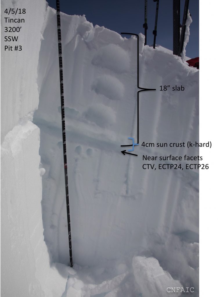
It has been two days since a storm with strong wind ended and left behind 1-2 feet of snow across our region. Girdwood, Portage and the Northern side of Turnagain Pass received 18” – 24” and much less on the far Southern end of Turnagain Pass. Rapid warming from the sun, whumpfing, cracking and remote triggered avalanches have occurred over the last two days with most of the activity on Thursday. A handful of storm slabs have been triggered by skiers, boarders and snowmachiners on smaller terrain features in Turnagain Pass. The largest of these slabs released on Thursday on a SW aspect of Tincan late afternoon and may have been remotely triggered from the skin track 300+ feet away. Stability tests on a nearby slope revealed a reactive layer of facets above and below an old sun crust. This structure is present on many Southerly aspects (E – S – SW) and could be more reactive later in the day with warming. A new sun crust has formed on the surface, which is helping stability until it starts to melt today. On North to West aspects where the snow is drier, weak faceted snow sits below the new snow, and triggering a slab 1-2 feet thick will remain possible at any time of the day. Fast moving dry-loose “sluff” is also possible in steeper terrain in shaded areas.  

Overcast skies should become partly cloudy by late afternoon. This could be our warmest day of the year with temperature reaching the low-50F’s near sea level, mid-30F’s near ridgetops. It is important to pay close attention to how warm it gets and how wet the snow feels. Ease into terrain with a cautious mind-set and be ready to adjust your plans if you experience collapsing, shoot cracks, or see any avalanche activity.

An avalanche that released between 4pm and 5pm on Thursday on a SW aspect of Hippy Bowl on Tincan. Its unknown if this avalanche was natural or triggered remotely from the skin track. 


 Several snow pits on Thursday found propagation potential on facets associated with an old sun crust on Southerly aspects in two locations nearby the avalanche above. 

Avalanche Problem 2
  • Wet Loose
    Wet Loose
  • Certain
    Very Likely
    Likely
    Possible
    Unlikely
    Likelihood
  • Historic (D4-5)
    Very Large (D3)
    Large (D2)
    Small (D1)
    Size
Wet Loose
Wet Loose avalanches are the release of wet unconsolidated snow or slush. These avalanches typically occur within layers of wet snow near the surface of the snowpack, but they may quickly gouge into lower snowpack layers. Like Loose Dry Avalanches, they start at a point and entrain snow as they move downhill, forming a fan-shaped avalanche. Other names for loose-wet avalanches include point-release avalanches or sluffs. Loose Wet avalanches can trigger slab avalanches that break into deeper snow layers.

Likelihood of Avalanches
Terms such as "unlikely", "likely", and "certain" are used to define the scale, with the chance of triggering or observing avalanches increasing as we move up the scale. For our purposes, "Unlikely" means that few avalanches could be triggered in avalanche terrain and natural avalanches are not expected. "Certain" means that humans will be able to trigger avalanches on many slopes, and natural avalanches are expected.

Size of Avalanches
Avalanche size is defined by the largest potential avalanche, or expected range of sizes related to the problem in question. Assigned size is a qualitative estimate based on the destructive classification system and requires specialists to estimate the harm avalanches may cause to hypothetical objects located in the avalanche track (AAA 2016, CAA 2014). Under this schema, "Small" avalanches are not large enough to bury humans and are relatively harmless unless they carry people over cliffs or through trees or rocks. Moving up the scale, avalanches become "Large" enough to bury, injure, or kill people. "Very Large" avalanches may bury or destroy vehicles or houses, and "Historic" avalanches are massive events capable of altering the landscape.

Signal Word Size (D scale) Simple Descriptor
Small 1 Unlikely to bury a person
Large 2 Can bury a person
Very Large 3 Can destroy a house
Historic 4 & 5 Can destroy part or all of a village
More info at Avalanche.org

SPRINGTIME WARMING: Dozens of small wet loose avalanches occurred on South and Southeast aspects in the afternoon on Thursday, just after the storm ended. Today a thin surface crust will require more energy to break down, but warmer air has already started to move into region and the sun should poke through the clouds by the afternoon. Sun and thin cloud cover can trap the heat and sometimes intensify the affects of solar heating. A thin crust has formed below 1000’ on all aspects and its also present on Southerly aspects (E – SW) at all elevations. If/when this crust softens and becomes moist, its time to avoid South aspects. Natural wet-loose avalanche activity will be possible near rocks and in steep terrain today.

Wet loose avalanches seen on Pete’s North and Pete’s South were visible Thursday evening. Although these point releases are small there is potential for a wet avalanche to trigger a 1-2′ slab if the crusts become saturated.

Additional Concern
  • Deep Persistent Slabs
    Deep Persistent Slabs
Deep Persistent Slabs
Deep Persistent Slab avalanches are the release of a thick cohesive layer of hard snow (a slab), when the bond breaks between the slab and an underlying persistent weak layer deep in the snowpack. The most common persistent weak layers involved in deep, persistent slabs are depth hoar or facets surrounding a deeply buried crust. Deep Persistent Slabs are typically hard to trigger, are very destructive and dangerous due to the large mass of snow involved, and can persist for months once developed. They are often triggered from areas where the snow is shallow and weak, and are particularly difficult to forecast for and manage.
More info at Avalanche.org

This new snow fell onto a snowpack with poor structure and several weak layers buried 2-4’ below the old surface. No avalanches have been reported on deeper layers of the snowpack. There remains some level uncertainty around the reactivity of these older weak layers, facets and buried surface hoar. Thin snowpack zones such as the Girdwood Valley and the South end of Turnagain Pass are more suspect for this structure, as well as some Northern and Easterly slopes with a generally thinner pack. Trigger points in this situation are often in thinner areas near rocks, but it is also possible to trigger this avalanche problem from areas along ridges. 

Weather
Sat, April 7th, 2018

Yesterday was overcast with a few sprinkles of rain, but no measurable amounts were recorded.   Daytime temperatures were in mid-20F’s near ridgetops and upper-30F’s at sea level. Warmer air and cloud cover kept overnight temperatures in the mid-20F’s in the alpine and low-30F’s near sea level. Northeast winds were 5-15mph most of the day near ridgetops.  

Mostly cloudy skies are expected to become partly cloudy this afternoon. Today could be our warmest day of the year with lower elevation temperatures in the upper-40’s to low-50F and upper elevation temps reaching the mid-30F’s.   Overnight lows are expected to dip below freezing into the mid-20F’s. Northwest winds could range from calm to 10mph today.  

Sunday looks very similar with partly cloudy weather and warmer daytime temperatures. Low temps should dip below freezing at night. Winds are expected to be light and variable. Monday evening through Tuesday there’s a chance for rain and snow showers and moderate winds, but accumulation looks minimal at this point.  

PRECIPITATION 24-hour data (6am – 6am)

  Temp Avg (F) Snow (in) Water (in) Snow Depth (in)
Center Ridge (1880′) 31 0   0   82  
Summit Lake (1400′) 34    0  0 34  
Alyeska Mid (1700′) 31   0   0    79

RIDGETOP 24-hour data (6am – 6am)

  Temp Avg (F) Wind Dir Wind Avg (mph) Wind Gust (mph)
Sunburst (3812′) 24   NE   6   20  
Seattle Ridge (2400′) 28   ESE   9   21  
Observations
Recent Observations for Turnagain Pass
Date Region Location
03/27/24 Turnagain Observation: Tincan Trees
03/26/24 Turnagain Observation: Cornbiscuit
03/25/24 Turnagain Observation: Tincan
03/22/24 Turnagain Avalanche: Magnum Northwest Aspect
03/21/24 Turnagain Observation: Sunburst
03/21/24 Turnagain Observation: Tincan Proper North Aspect
03/20/24 Turnagain Avalanche: Seattle Creek Drainage
03/19/24 Turnagain Observation: Tincan CFR
03/18/24 Turnagain Avalanche: Tincan – Eddies – Seattle Ridge
03/18/24 Turnagain Observation: Tincan
Riding Areas

The riding areas page has moved. Please click here & update your bookmarks.


Subscribe to Turnagain Pass
Avalanche Forecast by Email

This is a general backcountry avalanche advisory issued for Turnagain Arm with Turnagain Pass as the core advisory area. This advisory does not apply to highways, railroads or operating ski areas.