Turnagain Pass Avalanche Forecast RSS

Archives
ARCHIVED FORECAST - All forecasts expire after 24 hours from the posting date/time.
Issued
Wed, March 28th, 2018 - 7:00AM
Expires
Thu, March 29th, 2018 - 7:00AM
Forecaster
Heather Thamm
Avalanche risk The Bottom Line

The avalanche danger continues to be  MODERATE  above 1500′ on all aspects. Triggering a hard slab avalanche 2-4 feet thick remains a possibility. These hard slabs can be remotely triggered from the side or below. Additionally, watch for old wind slabs in steep rocky terrain and give cornices a wide berth.  

Similar avalanche concerns exist in the  Summit Lake area    and other zones on the Kenai.

Thanks to our sponsors!
Wed, March 28th, 2018
Alpine
Above 2,500'
Moderate (2)
Avalanche risk
Treeline
1,000'-2,500'
Moderate (2)
Avalanche risk
Below Treeline
Below 1,000'
Low (1)
Avalanche risk
Alpine
Above 2,500'
Avalanche risk
Moderate (2)
Treeline
1,000'-2,500'
Avalanche risk
Moderate (2)
Below Treeline
Below 1,000'
Avalanche risk
Low (1)
Danger Scale:
No Rating (0)
Low (1)
Moderate (2)
Considerable (3)
High (4)
Extreme (5)
Avalanche Problem 1
  • Deep Persistent Slabs
    Deep Persistent Slabs
  • Almost Certain
    Very Likely
    Likely
    Possible
    Unlikely
    Likelihood
  • Historic (D4-5)
    Very Large (D3)
    Large (D2)
    Small (D1)
    Size
Deep Persistent Slabs
Deep Persistent Slab avalanches are the release of a thick cohesive layer of hard snow (a slab), when the bond breaks between the slab and an underlying persistent weak layer deep in the snowpack. The most common persistent weak layers involved in deep, persistent slabs are depth hoar or facets surrounding a deeply buried crust. Deep Persistent Slabs are typically hard to trigger, are very destructive and dangerous due to the large mass of snow involved, and can persist for months once developed. They are often triggered from areas where the snow is shallow and weak, and are particularly difficult to forecast for and manage.

Likelihood of Avalanches
Terms such as "unlikely", "likely", and "certain" are used to define the scale, with the chance of triggering or observing avalanches increasing as we move up the scale. For our purposes, "Unlikely" means that few avalanches could be triggered in avalanche terrain and natural avalanches are not expected. "Certain" means that humans will be able to trigger avalanches on many slopes, and natural avalanches are expected.

Size of Avalanches
Avalanche size is defined by the largest potential avalanche, or expected range of sizes related to the problem in question. Assigned size is a qualitative estimate based on the destructive classification system and requires specialists to estimate the harm avalanches may cause to hypothetical objects located in the avalanche track (AAA 2016, CAA 2014). Under this schema, "Small" avalanches are not large enough to bury humans and are relatively harmless unless they carry people over cliffs or through trees or rocks. Moving up the scale, avalanches become "Large" enough to bury, injure, or kill people. "Very Large" avalanches may bury or destroy vehicles or houses, and "Historic" avalanches are massive events capable of altering the landscape.

Signal Word Size (D scale) Simple Descriptor
Small 1 Unlikely to bury a person
Large 2 Can bury a person
Very Large 3 Can destroy a house
Historic 4 & 5 Can destroy part or all of a village
More info at Avalanche.org

Triggering a hard slab avalanche 2-4’ deep is still our primary concern in the backcountry despite the quiet weather. It has been five days since the last human triggered avalanche, and over a week since a wind event triggered some large natural avalanches in our region. Traffic has been light and not many folks have been pushing into steep terrain. Hiding under the snow surface are weak layers in the snowpack formed in January that just will not go away. Without any big changes in the weather, these older layers (facets and buried surface hoar) are becoming more and more difficult to trigger. Hence, we are in a low probability, high consequence situation. The tricky part about this is, the pack appears to be stable but the chance remains for an unmanageable and destructive avalanche if a person hits just the wrong spot. These trigger spots will be in thinner areas of the snowpack near rocks or in scoured areas along ridges. Although triggering a slab remotely is becoming less likely with time, it’s not out of the question on a flat area below or next to a slope. Pay attention to runout zones and minimize your exposure on or under steep slopes. No obvious signs of instability my be present before a slope releases and it may be the 10th skier or snowmachiner onto a slope that finds a trigger point.

Today skies are expected to be mostly cloudy with clear skies through the end of the week. There is little in the way of weather that will impact our old and tired snowpack – except for the sun. We can’t forget that spring is here; even though temperatures have been relatively cool, this could change any day now. Be aware of warming later in the day on Southerly slopes – this may be difficult to assess. Melting surfaces may not be present on low angle terrain in the alpine. 

Other avalanche issues to keep in mind: 

Wind Slabs:  Old hard wind slabs are sitting on a variety of aspects due to prior unusual loading patterns. Steep and rocky terrain may harbor shallow windslabs sitting on old weak snow. This type of terrain (a steep unsupported slope) is also suspect for triggering a deeper slab mentioned above. 

Cornices: Many cornices are quite large and teetering over. Temperatures have been cool lately but as we head into warmer, sunnier weather remember this can help de-stabilize them. As always, give cornices plenty of space and limit exposure underneath them.

In the upper elevations we have been tracking a widespread layer of facets mixed with buried surface hoar  and in the mid elevations facets are sitting on a slick melt/freeze crust.


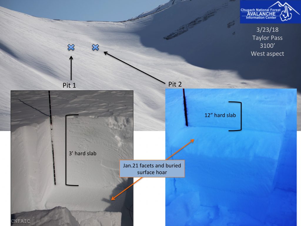
The slab on top is 2-4′ thick and very hard due to a strong Northwest wind event that ended last Thursday. This wind event caused unusual loading patterns on a variety of aspects as seen on the Headwall of Seattle Ridge. 

Weather
Wed, March 28th, 2018

Yesterday skis were clear in the morning becoming cloudy later in the day. Daytime high temperatures near sea level reached the low 40F’s and overnight dipped just below freezing 31F.   Ridgetop temperatures were in the upper 20F’s yesterday and cooled into the low 20F’s overnight. A trace of snow was observed yesterday evening, but no measurable amounts were recorded. Ridge top winds were light and variable.  

Today skies will be overcast in the morning becoming partly cloudy by the afternoon. A few flurries are possible. Winds will be light from the Northwest. Daytime temperatures may reach the mid 30F’s in the upper elevations and low 40F’s at sea level. Overnight temperatures will drop back into the the low 20F’s.

Skies are expected to be mostly sunny through the end of the week. Daytime temperatures should range from the mid-20’s to mid-30’s in the upper elevations and could reach the low 40’s F at sea level. Low temps at night will be the teens to low 20F’s. Northwest ridgetop winds near the end of the week may increase to Moderate.  

PRECIPITATION 24-hour data (6am – 6am)

  Temp Avg (F) Snow (in) Water (in) Snow Depth (in)
Center Ridge (1880′) 29   0   0   77  
Summit Lake (1400′) 29   0    0 31  
Alyeska Mid (1700′) 28   trace .01   72  

RIDGETOP 24-hour data (6am – 6am)

  Temp Avg (F) Wind Dir Wind Avg (mph) Wind Gust (mph)
Sunburst (3812′) 20   WSW   4   14  
Seattle Ridge (2400′) 25   ESE   5   18  
Observations
Recent Observations for Turnagain Pass
Date Region Location
05/22/23 Turnagain Avalanche: Tincan
05/12/23 Turnagain Avalanche: Tincan, Sunburst, Magnum, Cornbiscuit
05/07/23 Turnagain Observation: Tincan – Bear Tracks
05/05/23 Turnagain Observation: Seattle Ridge
05/02/23 Turnagain Observation: Cornbiscuit
05/02/23 Turnagain Observation: Seward Hwy Turnagain Pass
04/30/23 Turnagain Observation: Magnum
04/29/23 Turnagain Observation: Tincan
04/28/23 Turnagain Avalanche: Taylor Pass/Pastoral
04/28/23 Turnagain Avalanche: Tincan
Riding Areas
Updated Sat, September 23rd, 2023

Status of riding areas across the Chugach NF is managed by the Glacier and Seward Ranger Districts, not avalanche center staff. Riding area information is posted as a public service to our users and updated based on snow depth and snow density to prevent resource damage at trailhead locations. Riding area questions contact: mailroom_r10_chugach@fs.fed.us

Area Status Weather & Riding Conditions
Glacier District
Johnson Pass
Closed
Scheduled opening per Chugach National Forest plan December 1. Subject to adequate snow cover.
Placer River
Closed
Scheduled opening per Chugach National Forest plan December 1. Subject to adequate snow cover.
Skookum Drainage
Closed
Scheduled opening per Chugach National Forest plan December 1. Subject to adequate snow cover.
Turnagain Pass
Closed
Scheduled opening on the Wednesday before Thanksgiving per Chugach National Forest plan. Subject to adequate snow cover.
Twentymile
Closed
Scheduled opening per Chugach National Forest plan December 1. Subject to adequate snow cover.
Seward District
Carter Lake
Closed
Scheduled opening per Chugach National Forest plan December 1. Subject to adequate snow cover.
Lost Lake Trail
Closed
Scheduled opening per Chugach National Forest plan December 1. Subject to adequate snow cover.
Primrose Trail
Closed
Scheduled opening per Chugach National Forest plan December 1. Subject to adequate snow cover.
Resurrection Pass Trail
Closed
Scheduled opening per Chugach National Forest plan December 1. Subject to adequate snow cover.
Snug Harbor
Closed
Scheduled opening per Chugach National Forest plan December 1. Subject to adequate snow cover.
South Fork Snow River Corridor
Closed
Scheduled opening per Chugach National Forest plan December 1. Subject to adequate snow cover.
Summit Lake
Closed
Scheduled opening per Chugach National Forest plan December 1. Subject to adequate snow cover.

Subscribe to Turnagain Pass
Avalanche Forecast by Email

This is a general backcountry avalanche advisory issued for Turnagain Arm with Turnagain Pass as the core advisory area. This advisory does not apply to highways, railroads or operating ski areas.