Turnagain Pass |
Archives |
A CONSIDERABLE avalanche danger remains at elevations above 1,500′ in the Turnagain Pass area. Triggering a large slab avalanche was likely yesterday and trending toward possible today. However, it is only the 2nd day after a storm and these slabs are 2-5+’ thick and unmanageable. Today is a day to follow the ‘travel advice’ for CONSIDERABLE danger: Careful snowpack evaluation, cautious route-finding and conservative decision making. A LOW avalanche danger exists below 1,500′ where triggering an avalanche is unlikely.
Travel Advice | Generally safe avalanche conditions. Watch for unstable snow on isolated terrain features. | Heightened avalanche conditions on specific terrain features. Evaluate snow and terrain carefully; identify features of concern. | Dangerous avalanche conditions. Careful snowpack evaluation, cautious route-finding, and conservative decision-making essential. | Very dangerous avalanche conditions. Travel in avalanche terrain not recommended. | Extraordinarily dangerous avalanche conditions. Avoid all avalanche terrain. |
Likelihood of Avalanches | Natural and human-triggered avalanches unlikely. | Natural avalanches unlikely; human-triggered avalanches possible. | Natural avalanches possible; human-triggered avalanches likely. | Natural avalanches likely; human-triggered avalanches very likely. | Natural and human-triggered avalanches certain. |
Avalanche Size and Distribution | Small avalanches in isolated areas or extreme terrain. | Small avalanches in specific areas; or large avalanches in isolated areas. | Small avalanches in many areas; or large avalanches in specific areas; or very large avalanches in isolated areas. | Large avalanches in many areas; or very large avalanches in specific areas. | Very large avalanches in many areas. |
Signal Word | Size (D scale) | Simple Descriptor |
Small | 1 | Unlikely to bury a person |
Large | 2 | Can bury a person |
Very Large | 3 | Can destroy a house |
Historic | 4 & 5 | Can destroy part or all of a village |
Storm slabs, wind slabs and cornice falls associated with the heavy snowfall two days ago are still an issue today. Although the bonding of the new snow to the old snow surface is occurring quickly, slabs and cornices may still be triggered. Yesterday there were three large avalanches seen/reported in the Turnagain Pass zone. Two of these were in Main Bowl of Seattle Creek and were storm slabs triggered by snowmachiners. One was triggered by a cornice fall and one was remotely triggered from above. The third avalanche was on the SE face of Seattle Ridge and is unknown if this was a natural slide or triggered remotely from a snowmachiner(s) on the ridge. An avalanche course heard the slide from across the valley. This third avalanche looks to have stepped down into deeper weak layers in the pack. See photos below.
For today, if visibility allows for travel to the upper elevations, know that these types of avalanches remain possible. Furthermore, cornices have grown and could break farther back than expected. It is only the 2nd day out of a storm and don’t expect all slopes to remain intact. Although triggering a storm slab or wind slab avalanche will be less likely today, these slides can be large and have high consequences. Quick hand pits and getting your shovel out to look at the new/old snow bonding is a good way to help assess the slopes you are interested in riding. Assessing deeper weak layers in the pack is more difficult – more on that below. Keeping with safe travel habits, chiefly exposing only one person at time if venturing into avalanche terrain is key. Watch your buddies closely.
Close up of the crown of avalanche above, note the dark bed surface, this avalanche ‘stepped down’ into weak snow near the ground
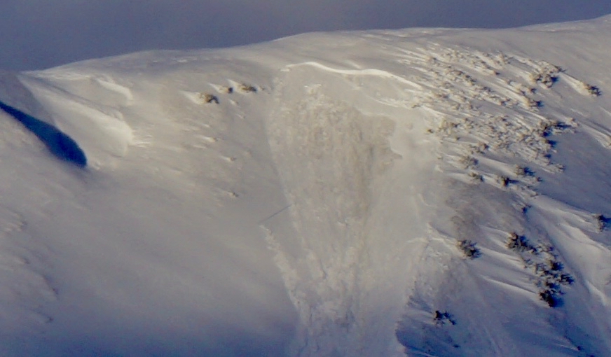
Yesterday a snowmachine triggered a cornice fall, which triggered this storm slab avalanche in Main Bowl (1st Bowl) in the Seattle Creek drainage.
Signal Word | Size (D scale) | Simple Descriptor |
Small | 1 | Unlikely to bury a person |
Large | 2 | Can bury a person |
Very Large | 3 | Can destroy a house |
Historic | 4 & 5 | Can destroy part or all of a village |
Triggering a deep persistent slab is just as concerning, if not more concerning, as the avalanche issues in the new snow. This is because these can be larger and more destructive avalanches. Underneath the storm snow sit a variety of weak layers deeper in the snowpack. The first is the New Year’s buried surface hoar that is anywhere from 30″ to ~5′ deep (general snow depths vary widely due to wind distribution and snowfall differences). This layer was showing signs of being reactive in pits yesterday – it took a bit of force to fail, but once it fails, it’s sliding easily. There are also facets that have been found near crusts in the mid to lower pack as well as basal facets that sit near the ground. The point is, this is a complicated snowpack that just received a lot of weight – avalanches triggered deeper in the pack can be very large and unsurvivable.
Video of failure in the New Year’s buried surface hoar on Sunburst ridge, while the storm snow has bonded well in this area
Partly sunny skies filled the area yesterday with no precipitation. Ridgetop winds bumped up to the 30’s with gusts in the 50’s mph yesterday morning from the East before tapering off significantly in the afternoon and overnight have been light and variable. Temperatures remained warm, in the mid to upper 20’sF along ridgetops and in the mid 30’sF below 1,000′. A slight inversion is in place this morning with valley bottoms in the upper 20’sF.
Today, we are just on the edge of some instability showers to our Northeast. We may see partly clear skies with no precipitation, yet we may also see these showers back down our way to bring 1-2″ of snow above 1,500 and light rain (.2″) below this. Ridgetop winds are expected to be relatively light, 5-15mph from the East today and into tonight. Temperatures will stay on the warm side with mid 30’sF at 1,000′ and the upper 20’sF along the ridgelines.
Early tomorrow another warm storm system moves in from the East. As of now, the rain/snow line looks to be around 2,000′ and possibly higher. Models are showing precipitation amounts in the 1-2″ of rain and 1-2+ feet of snow up high by Wednesday night. Stay tuned and cross your fingers for a lower rain line.
*A big THANKS to the folks who cleared off the Seattle Ridge weather station yesterday!
Temp Avg (F) | Snow (in) | Water (in) | Snow Depth (in) | |
Center Ridge (1880′) | 31 | 0 | 0 | 60 |
Summit Lake (1400′) | 28 | 0 | 0 | 15 |
Alyeska Mid (1700′) | 33 | trace | 0.04 | 48 |
Temp Avg (F) | Wind Dir | Wind Avg (mph) | Wind Gust (mph) | |
Sunburst (3812′) | 27 | NE | 21 | 55 |
Seattle Ridge (2400′) | 29 | SE | 15 | 30 |
Date | Region | Location | Observer |
---|---|---|---|
10/27/24 | Turnagain | Observation: Tincan | Michael Kerst |
10/21/24 | Turnagain | Observation: Turnagain Pass Road Observation | Trevor Clayton |
10/19/24 | Turnagain | Observation: Tincan – Below Todds Run | Andy Moderow |
10/18/24 | Turnagain | Observation: Taylor Pass | Eli Neuffer |
10/15/24 | Turnagain | Observation: Tincan Common | John Sykes Forecaster |
10/14/24 | Turnagain | Avalanche: Tincan | CNFAC Staff |
05/13/24 | Turnagain | Observation: Eddie’s, Sunburst, Seattle, Cornbiscuit, Pete’s South | H Thamm |
05/13/24 | Turnagain | Observation: Turnagain Pass non-motorized side | Amy Holman |
05/12/24 | Turnagain | Observation: Warm up Bowl | Tony Naciuk |
05/07/24 | Turnagain | Observation: Turnagain Pass Wet Slabs | A S |
The riding areas page has moved. Please click here & update your bookmarks.
Subscribe to Turnagain Pass
Avalanche Forecast by Email