Turnagain Pass
|
![]() ![]() |
The avalanche danger is CONSIDERABLE on all slopes above 1,000′. Triggering a 2-3+’ large slab avalanche, composed of the new snow, is likely above 1,500′. Wet slab avalanches near and below 1,500′ are possible. Naturally occurring avalanches are also possible. Additionally, avalanches could break in deeper layers of the snowpack, causing a much larger slide. Below 1,000′ the avalanche danger is MODERATE for wet loose avalanches.
*Today is a day to let the mountains adjust to the several feet of recent new snow. Cautious route-finding and conservative decision-making will be essential.
![]() |
![]() |
![]() |
![]() |
![]() |
|
Travel Advice | Generally safe avalanche conditions. Watch for unstable snow on isolated terrain features. | Heightened avalanche conditions on specific terrain features. Evaluate snow and terrain carefully; identify features of concern. | Dangerous avalanche conditions. Careful snowpack evaluation, cautious route-finding, and conservative decision-making essential. | Very dangerous avalanche conditions. Travel in avalanche terrain not recommended. | Extraordinarily dangerous avalanche conditions. Avoid all avalanche terrain. |
Likelihood of Avalanches | Natural and human-triggered avalanches unlikely. | Natural avalanches unlikely; human-triggered avalanches possible. | Natural avalanches possible; human-triggered avalanches likely. | Natural avalanches likely; human-triggered avalanches very likely. | Natural and human-triggered avalanches certain. |
Avalanche Size and Distribution | Small avalanches in isolated areas or extreme terrain. | Small avalanches in specific areas; or large avalanches in isolated areas. | Small avalanches in many areas; or large avalanches in specific areas; or very large avalanches in isolated areas. | Large avalanches in many areas; or very large avalanches in specific areas. | Very large avalanches in many areas. |
Signal Word | Size (D scale) | Simple Descriptor |
Small | 1 | Unlikely to bury a person |
Large | 2 | Can bury a person |
Very Large | 3 | Can destroy a house |
Historic | 4 & 5 | Can destroy part or all of a village |
A break in the weather has finally moved in after three days of rain, snow and wind. The rain/snow line rose to 1,500′ in places yesterday, and possibly higher, yet several feet of new snow is now in the mountains above 1,500′. During the past 24 hours between 1-2′ of new snow fell in the region. Favored locations were Portage Valley, Girdwood and the North end of Turnagain Pass.
STORM TOTALS near 2,000′ above the rain – Thursday morning through 6am Sunday morning:
Turnagain Pass 20-30″ (2.6″ of snow water equivalent)
Girdwood Valley 25-35″ (3.2″ of snow water equivalent)
Summit Lake 10-15″ (1.0″ of snow water equivalent)
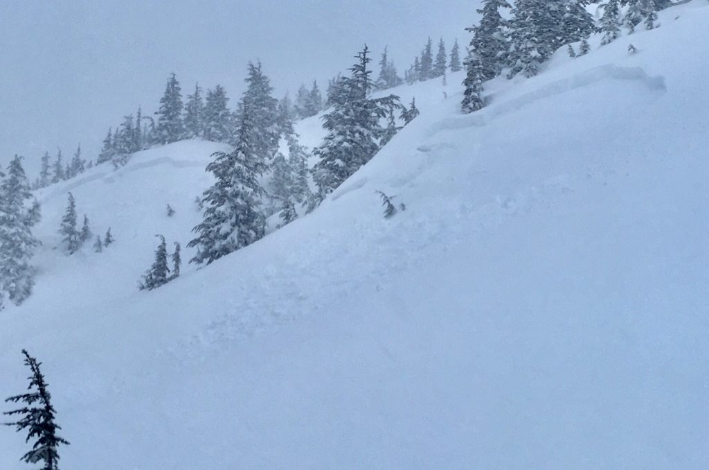
Avalanche activity was prevalent in the Tincan Trees yesterday due to heavy snowfall creating a ‘rapid loading’ event. All avalanches were failing under the total storm snow, at the new/old snow surface. The old snow surface is composed of small buried surface hoar (3-7mm) and near surface facets. These are persistent weak layers that don’t bond quickly. Hence, we can expect the storm snow to fail in these layers again today. With the storm past, natural avalanche activity will be decreasing but human triggered avalanches will remain likely. If you are headed out – keep these points in mind:
1- Slabs triggered will be deep (2-3+ feet) – these are dangerous and unmanageable avalanches
2- Avalanches could run further than expected
3- Remote triggering an avalanche from below, or near a slope is possible
4- Due to the depth of the storm snow, no signs of instability may be present before someone triggers a slab
*Giving the snowpack time to heal from these storms is key. Sticking to low angle terrain with nothing steeper above is recommended. Remember, it’s the first 2 days after a storm where most avalanche fatalities occur. Although there is nice powder at the upper elevations that can lure us, now is not the time to be sampling it.
Stom slab avalanches in the Tincan Trees yesterday. The slab on the left was believed to have been natural while the slab on the right was remotely triggered by a group ascending. Recent avalanches, Bulls Eye clues the snowpack is unstable.
Another storm slab avalanche triggered by a skier in the Tincan Trees, note the size of the slab (~2,5′ thick). Big thanks to the folks who sent this photo in to us.
–
Signal Word | Size (D scale) | Simple Descriptor |
Small | 1 | Unlikely to bury a person |
Large | 2 | Can bury a person |
Very Large | 3 | Can destroy a house |
Historic | 4 & 5 | Can destroy part or all of a village |
Rain fell on snow yesterday up to 1,500′ and today, light rain is expected to fall up to 2,200′. With these warm temperatures persisting, wet slab and wet loose avalanches remain possible. There have been some breaks in cloud cover overnight, which has likely helped to start freezing the snow surface at these lower elevations. However, clouds and light rain should move back in today softening any crusts that may have formed. Keep in mind that steep slopes with a wet and saturated snowpack are likely to slide. Even a small slope could have high consequences if heavy wet debris is able to pile up on a person.
Weak layers within the snowpack have the potential to re-activate with the added load of this week’s new snow (2-3+” of water weight). Additionally, avalanches in the storm snow, discussed above, could step down to these deeper layers and produce a very large avalanche depending on the size of the slope. In short, a layer of buried surface hoar from the New Year’s holiday sits roughly 3-6′ deep at this point and is a concern at elevations above 2,000′. Basal facets, near the ground, remain a concern at elevations above 3,000′.
Yesterday’s storm peaked around noon and brought 1-2″ of rain to 1,500′ in most locations with moist snow above this. The greater amounts of precipitation seen were in the Portage Valley area. Snowfall in the upper elevations varied from 1-2 feet; Girdwood Valley and the North end of Turnagain Pass saw near 2′ of snow while the South end of the Pass and Summit Lake saw 12-15″ of new snow. Ridgetop winds were strong from the East, averaging 30-60mph with gusts to 99mph. Temperatures were warm, around 36F at 1,000′ and the mid to upper 20’sF along ridgetops.
Currently, the fire hose of moisture has shifted to our East and precipitation has decreased significantly. Today we can expect light precipitation with 1-2″ of snow above 2,200′ and ~.1″ of rain below this. Skies could clear slightly at times before light precipitation moves back in for this evening along with cooler temperatures. We could see another 2-5″ inches of snow above 1,000′ and .3″ of rain below this. Ridgetop winds will remain Easterly and expected to be in the 15-25mph range.
For tomorrow, Martin Luther King Day, we can expect partly to mostly cloudy skies with light snow flurries. Temperatures should remain cool enough for snow to fall to 1,000′. The next system looks to move in on Tuesday and again is a warm one.
*Seattle Ridge anemometer is covered in rime from this storm and not functioning
Temp Avg (F) | Snow (in) | Water (in) | Snow Depth (in) | |
Center Ridge (1880′) | 32 | 11 | 1.3 | 66 |
Summit Lake (1400′) | 33 | rain | 0.9 | 15 |
Alyeska Mid (1700′) | 33 | 2 | 1.7 | 48 |
Temp Avg (F) | Wind Dir | Wind Avg (mph) | Wind Gust (mph) | |
Sunburst (3812′) | 25 | NE | 39 | 99 |
Seattle Ridge (2400′) | 28 | *n/a | *n/a | *n/a |
Date | Region | Location | Observer |
---|---|---|---|
10/27/24 | Turnagain | Observation: Tincan | Michael Kerst |
10/21/24 | Turnagain | Observation: Turnagain Pass Road Observation | Trevor Clayton |
10/19/24 | Turnagain | Observation: Tincan – Below Todds Run | Andy Moderow |
10/18/24 | Turnagain | Observation: Taylor Pass | Eli Neuffer |
10/15/24 | Turnagain | Observation: Tincan Common | John Sykes Forecaster |
10/14/24 | Turnagain | Avalanche: Tincan | CNFAC Staff |
05/13/24 | Turnagain | Observation: Eddie’s, Sunburst, Seattle, Cornbiscuit, Pete’s South | H Thamm |
05/13/24 | Turnagain | Observation: Turnagain Pass non-motorized side | Amy Holman |
05/12/24 | Turnagain | Observation: Warm up Bowl | Tony Naciuk |
05/07/24 | Turnagain | Observation: Turnagain Pass Wet Slabs | A S |
The riding areas page has moved. Please click here & update your bookmarks.
Subscribe to Turnagain Pass
Avalanche Forecast by Email