Turnagain Pass Avalanche Forecast RSS

Archives
ARCHIVED FORECAST - All forecasts expire after 24 hours from the posting date/time.
Issued
Sun, January 7th, 2018 - 7:00AM
Expires
Mon, January 8th, 2018 - 7:00AM
Forecaster
Wendy Wagner
Avalanche risk The Bottom Line

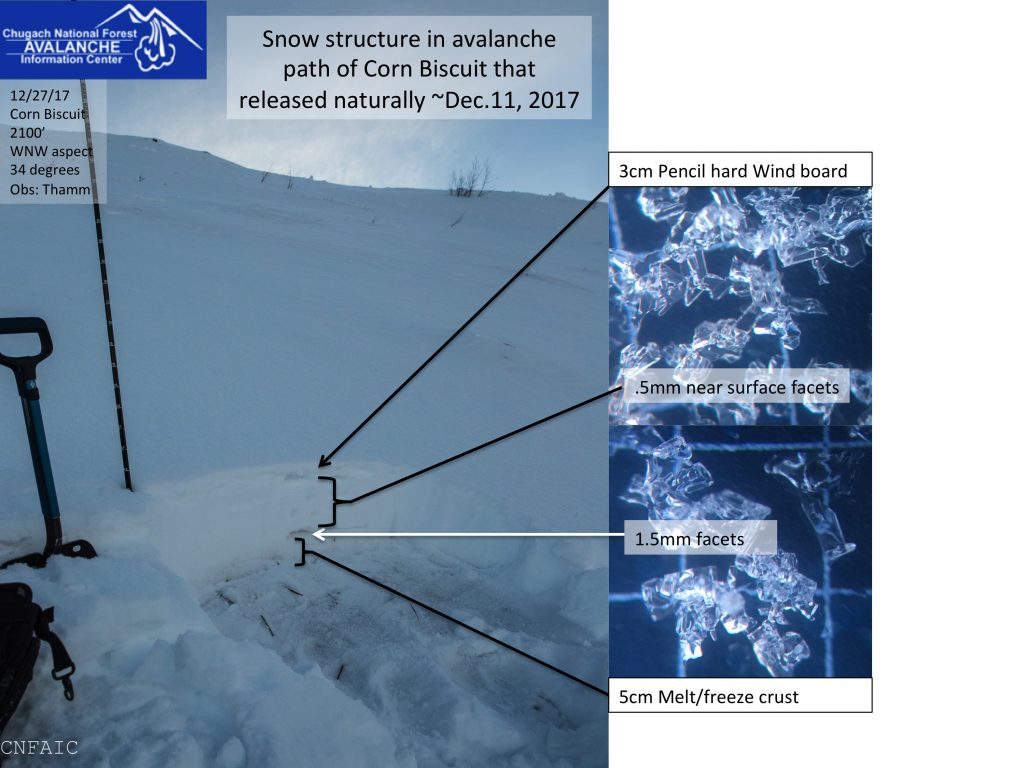
The avalanche danger remains CONSIDERABLE for the travel advice portion of the danger scale. Triggering a slab avalanche 1-3′ thick at elevations 2,000′ and higher is possible and may still be likely in places. Additionally, triggering a larger slab breaking near the ground remains possible at elevations above 3,000′. Careful snowpack evaluation, cautious route-finding and conservative decision-making are essential in the Alpine.  Sticking to low consequence terrain 30 degrees and less, and out of runout zones, is recommended above 2,000′ to simply avoid these issues. The danger is  MODERATE  between 2,000-2,500′ and a  LOW danger exists below 2,000′.

Special Announcements

Turnagain Pass is open to motorized use.  A  Special Avalanche Bulletin  has been issued this weekend due to an unstable snowpack in an area with little information  combined with anticipated crowds.  The Chugach National Forest wants to remind riders to avoid areas with thin snow cover like €œRookie Hill € and the Southern end of Turnagain Pass towards Bertha Creek. Johnson Pass remains closed due to lack of snow.  

*Coming up January 13th is a FREE avalanche rescue clinic at Hatcher Pass. Practice with your gear on your way to the backcountry – clinic runs from 11am – 1:30pm.  

Thanks to our sponsors!
Sun, January 7th, 2018
Alpine
Above 2,500'
Considerable (3)
Avalanche risk
Treeline
1,000'-2,500'
Moderate (2)
Avalanche risk
Below Treeline
Below 1,000'
Low (1)
Avalanche risk
Alpine
Above 2,500'
Avalanche risk
Considerable (3)
Treeline
1,000'-2,500'
Avalanche risk
Moderate (2)
Below Treeline
Below 1,000'
Avalanche risk
Low (1)
Danger Scale:
No Rating (0)
Low (1)
Moderate (2)
Considerable (3)
High (4)
Extreme (5)
Avalanche Problem 1
  • Persistent Slabs
    Persistent Slabs
  • Almost Certain
    Very Likely
    Likely
    Possible
    Unlikely
    Likelihood
  • Historic (D4-5)
    Very Large (D3)
    Large (D2)
    Small (D1)
    Size
Persistent Slabs
Persistent Slab avalanches are the release of a cohesive layer of snow (a slab) in the middle to upper snowpack, when the bond to an underlying persistent weak layer breaks. Persistent layers include: surface hoar, depth hoar, near-surface facets, or faceted snow. Persistent weak layers can continue to produce avalanches for days, weeks or even months, making them especially dangerous and tricky. As additional snow and wind events build a thicker slab on top of the persistent weak layer, this avalanche problem may develop into a Deep Persistent Slab.

Likelihood of Avalanches
Terms such as "unlikely", "likely", and "certain" are used to define the scale, with the chance of triggering or observing avalanches increasing as we move up the scale. For our purposes, "Unlikely" means that few avalanches could be triggered in avalanche terrain and natural avalanches are not expected. "Certain" means that humans will be able to trigger avalanches on many slopes, and natural avalanches are expected.

Size of Avalanches
Avalanche size is defined by the largest potential avalanche, or expected range of sizes related to the problem in question. Assigned size is a qualitative estimate based on the destructive classification system and requires specialists to estimate the harm avalanches may cause to hypothetical objects located in the avalanche track (AAA 2016, CAA 2014). Under this schema, "Small" avalanches are not large enough to bury humans and are relatively harmless unless they carry people over cliffs or through trees or rocks. Moving up the scale, avalanches become "Large" enough to bury, injure, or kill people. "Very Large" avalanches may bury or destroy vehicles or houses, and "Historic" avalanches are massive events capable of altering the landscape.

Signal Word Size (D scale) Simple Descriptor
Small 1 Unlikely to bury a person
Large 2 Can bury a person
Very Large 3 Can destroy a house
Historic 4 & 5 Can destroy part or all of a village
More info at Avalanche.org

Several days of generally quiet weather is allowing the snowpack to slowly adjust and theoretically avalanches are becoming less likely to trigger. There was a spike in Easterly winds on Friday afternoon that loaded certain slopes, but other than this no load has been added since Wednesday. Time is on our side, but with that said, we have several weak layers in the snowpack. The pack is getting to the point it may not show any signs of instability until an avalanche is triggered. Many folks may ride/ski a slope before someone hits just the wrong spot. It’s a tricky situation. 

Points to keep in mind if you are headed out today and the visibility opens enough for travel above treeline:

1-  Slab avalanches 1-3′ thick will be possible to trigger, and may even remain likely to trigger on certain slopes
2-  The snowpack is likely to ‘feel’ stable and not show its cards till it’s too late (several tracks may be on a slope before it releases)
3-  Safe travel protocol is key to stacking the odds in your group’s favor if choosing to ride upper elevation avalanche terrain (i.e., exposing one person at a time)
4-  Avalanches triggered can be large and unsurvivable

Over the past week we have been concerned about a layer of buried surface hoar that sits 1-3′ deep (buried by the New Year’s storm). This layer remains reactive in pits between 2,000-3,200′, yet it remains untested at the higher elevations. We are also concerned about a layer of faceted snow that sits near the ground on slopes that avalanched in early December. Both these issues are in the top three feet of the snowpack and are responsible for these ‘persistent slab’ avalanche problems. Quick note of thanks to the many folks writing in to help us assess the layers!

Plumes on the Twin Peaks near Silvertip, created by Easterly winds on Friday afternoon.

Snowpack just above treeline on Tincan – buried surface hoar main concern for human triggered avalanches

Many tracks on a slope – snow is complex, we know there are weak layers lurking, don’t assume the slope next door will allow that many tracks.

Seattle Ridge, just open to motorized use – very little information for this zone, please let us know what you see if you head this way!

Avalanche Problem 2
  • Deep Persistent Slabs
    Deep Persistent Slabs
  • Almost Certain
    Very Likely
    Likely
    Possible
    Unlikely
    Likelihood
  • Historic (D4-5)
    Very Large (D3)
    Large (D2)
    Small (D1)
    Size
Deep Persistent Slabs
Deep Persistent Slab avalanches are the release of a thick cohesive layer of hard snow (a slab), when the bond breaks between the slab and an underlying persistent weak layer deep in the snowpack. The most common persistent weak layers involved in deep, persistent slabs are depth hoar or facets surrounding a deeply buried crust. Deep Persistent Slabs are typically hard to trigger, are very destructive and dangerous due to the large mass of snow involved, and can persist for months once developed. They are often triggered from areas where the snow is shallow and weak, and are particularly difficult to forecast for and manage.

Likelihood of Avalanches
Terms such as "unlikely", "likely", and "certain" are used to define the scale, with the chance of triggering or observing avalanches increasing as we move up the scale. For our purposes, "Unlikely" means that few avalanches could be triggered in avalanche terrain and natural avalanches are not expected. "Certain" means that humans will be able to trigger avalanches on many slopes, and natural avalanches are expected.

Size of Avalanches
Avalanche size is defined by the largest potential avalanche, or expected range of sizes related to the problem in question. Assigned size is a qualitative estimate based on the destructive classification system and requires specialists to estimate the harm avalanches may cause to hypothetical objects located in the avalanche track (AAA 2016, CAA 2014). Under this schema, "Small" avalanches are not large enough to bury humans and are relatively harmless unless they carry people over cliffs or through trees or rocks. Moving up the scale, avalanches become "Large" enough to bury, injure, or kill people. "Very Large" avalanches may bury or destroy vehicles or houses, and "Historic" avalanches are massive events capable of altering the landscape.

Signal Word Size (D scale) Simple Descriptor
Small 1 Unlikely to bury a person
Large 2 Can bury a person
Very Large 3 Can destroy a house
Historic 4 & 5 Can destroy part or all of a village
More info at Avalanche.org

In the Alpine, above 3,000’, human triggered large and dangerous deep slab avalanches are still possible. Weak sugary snow (basal facets) near the ground is creating a low probability/high consequence avalanche problem that is impossible to outsmart. This will take a long time to heal. A big trigger like a snowmachine or a slab avalanche in the upper layers of the snowpack may be enough force to initiate a deep slab avalanche. Likely trigger spots will be in thinner areas of the snowpack that are connected to large, loaded slopes. Cautious route-finding is essential. This includes thinking about the remote trigger potential from below.

Additional Concern
  • Announcement
    Announcement

Changes coming to this advisory page tomorrow! Please see this short document and video about the changes and reasons for them.


Weather
Sun, January 7th, 2018

Mostly cloudy skies were over the region yesterday with light precipitation falling early in the day. Around an inch of new snow was seen in most places with period of light rain at sea level. Temperatures were in the mid 20’sF along ridgetops and 32F at 1,000′. Ridgetop winds were light from the East in the 5-10mph range.  

Today, expect mostly cloudy skies with possible breaks in cloud cover. Scattered snow flurries could fall in places higher than 700′ with light rain below. Winds will be light and variable. Temperatures should reach 30-32F at 1,000′ and remain in the mid 20’s at ridgetops.

Monday and Tuesday look to be a true break in weather with mostly sunny skies. Wednesday is a chance for more flurries, but little accumulation expected. The next ‘real’ chance for snow may come this weekend.  

*Seattle Ridge anemometer is rimed and not reporting.

PRECIPITATION 24-hour data (6am – 6am)

  Temp Avg (F) Snow (in) Water (in) Snow Depth (in)
Center Ridge (1880′) 31   0   0   43  
Summit Lake (1400′) 26   0   0   16
Alyeska Mid (1700′) 30   1    0.06 38  

RIDGETOP 24-hour data (6am – 6am)

  Temp Avg (F) Wind Dir Wind Avg (mph) Wind Gust (mph)
Sunburst (3812′) 23   NE   7   27  
Seattle Ridge (2400′) 26   *n/a   *n/a     *n/a    
Observations
Recent Observations for Turnagain Pass
Date Region Location
05/22/23 Turnagain Avalanche: Tincan
05/12/23 Turnagain Avalanche: Tincan, Sunburst, Magnum, Cornbiscuit
05/07/23 Turnagain Observation: Tincan – Bear Tracks
05/05/23 Turnagain Observation: Seattle Ridge
05/02/23 Turnagain Observation: Cornbiscuit
05/02/23 Turnagain Observation: Seward Hwy Turnagain Pass
04/30/23 Turnagain Observation: Magnum
04/29/23 Turnagain Observation: Tincan
04/28/23 Turnagain Avalanche: Taylor Pass/Pastoral
04/28/23 Turnagain Avalanche: Tincan
Riding Areas
Updated Sat, September 23rd, 2023

Status of riding areas across the Chugach NF is managed by the Glacier and Seward Ranger Districts, not avalanche center staff. Riding area information is posted as a public service to our users and updated based on snow depth and snow density to prevent resource damage at trailhead locations. Riding area questions contact: mailroom_r10_chugach@fs.fed.us

Area Status Weather & Riding Conditions
Glacier District
Johnson Pass
Closed
Scheduled opening per Chugach National Forest plan December 1. Subject to adequate snow cover.
Placer River
Closed
Scheduled opening per Chugach National Forest plan December 1. Subject to adequate snow cover.
Skookum Drainage
Closed
Scheduled opening per Chugach National Forest plan December 1. Subject to adequate snow cover.
Turnagain Pass
Closed
Scheduled opening on the Wednesday before Thanksgiving per Chugach National Forest plan. Subject to adequate snow cover.
Twentymile
Closed
Scheduled opening per Chugach National Forest plan December 1. Subject to adequate snow cover.
Seward District
Carter Lake
Closed
Scheduled opening per Chugach National Forest plan December 1. Subject to adequate snow cover.
Lost Lake Trail
Closed
Scheduled opening per Chugach National Forest plan December 1. Subject to adequate snow cover.
Primrose Trail
Closed
Scheduled opening per Chugach National Forest plan December 1. Subject to adequate snow cover.
Resurrection Pass Trail
Closed
Scheduled opening per Chugach National Forest plan December 1. Subject to adequate snow cover.
Snug Harbor
Closed
Scheduled opening per Chugach National Forest plan December 1. Subject to adequate snow cover.
South Fork Snow River Corridor
Closed
Scheduled opening per Chugach National Forest plan December 1. Subject to adequate snow cover.
Summit Lake
Closed
Scheduled opening per Chugach National Forest plan December 1. Subject to adequate snow cover.

Subscribe to Turnagain Pass
Avalanche Forecast by Email

This is a general backcountry avalanche advisory issued for Turnagain Arm with Turnagain Pass as the core advisory area. This advisory does not apply to highways, railroads or operating ski areas.