Turnagain Pass RSS

Archives
ARCHIVED - Forecasts expire after 24 hours.
Issued
Sun, December 4th, 2016 - 7:00AM
Expires
Mon, December 5th, 2016 - 7:00AM
Forecaster
Wendy Wagner
Avalanche risk The Bottom Line

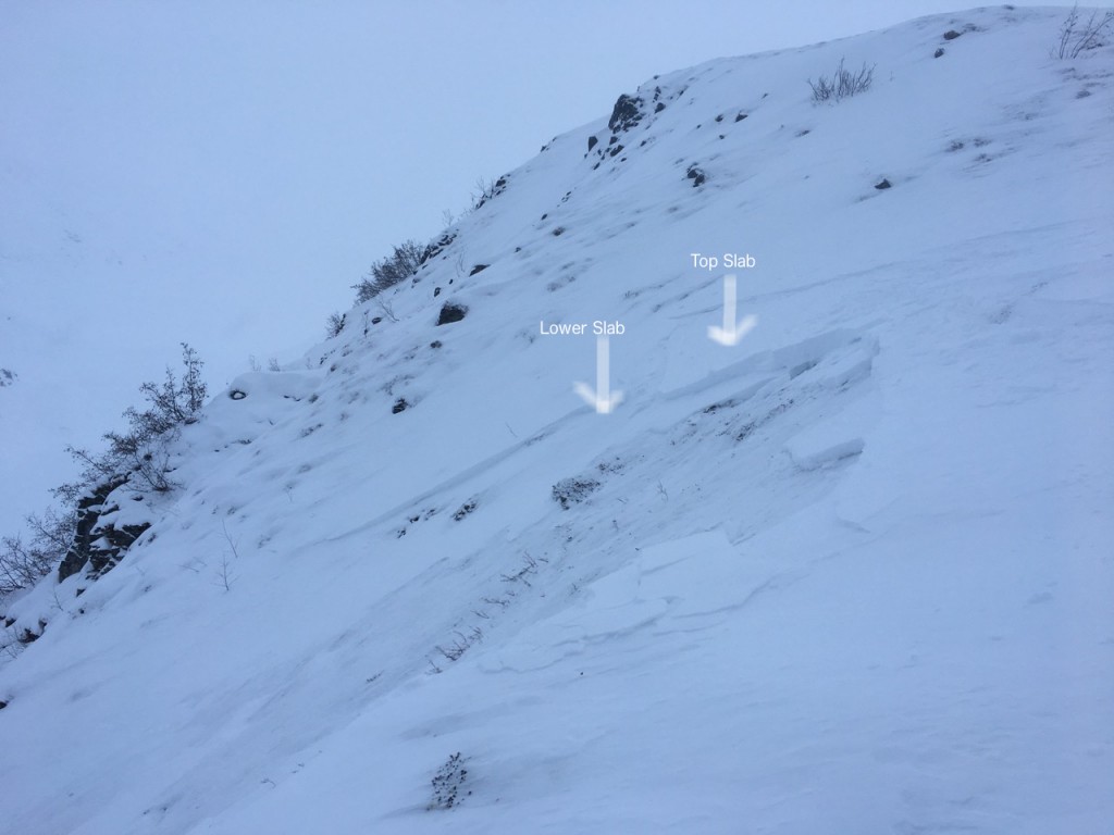
There remains a MODERATE avalanche danger on all slopes near and above treeline. Triggering a slab avalanche 1-2+’ thick is still possible and the likelihood goes up as one travels to areas that have had less traffic this season.  This is due to a buried layer of surface hoar that remains reactive. Additionally, triggering a classic wind slab avalanche is also possible today on steep slopes that have recently been loaded by winds.  

If you are headed to  Summit Lake take a look at Aleph’s weekly summary.

Special Announcements

Interested in forecasting snow/weather conditions for your day in the backcountry, or your weekend trip? Join us this Tuesday for a mountain weather talk  at Ski AK in Anchorage – 6:30-8pm!!

Sun, December 4th, 2016
Alpine
Above 2,500'
2 - Moderate
Avalanche risk
Treeline
1,000'-2,500'
1 - Low
Avalanche risk
Below Treeline
Below 1,000'
0 - No Rating
Avalanche risk
0 - No Rating
1 - Low
2 - Moderate
3 - Considerable
4 - High
5 - Extreme
Avalanche risk Avalanche risk Avalanche risk Avalanche risk Avalanche risk
Travel Advice Generally safe avalanche conditions. Watch for unstable snow on isolated terrain features. Heightened avalanche conditions on specific terrain features. Evaluate snow and terrain carefully; identify features of concern. Dangerous avalanche conditions. Careful snowpack evaluation, cautious route-finding, and conservative decision-making essential. Very dangerous avalanche conditions. Travel in avalanche terrain not recommended. Extraordinarily dangerous avalanche conditions. Avoid all avalanche terrain.
Likelihood of Avalanches Natural and human-triggered avalanches unlikely. Natural avalanches unlikely; human-triggered avalanches possible. Natural avalanches possible; human-triggered avalanches likely. Natural avalanches likely; human-triggered avalanches very likely. Natural and human-triggered avalanches certain.
Avalanche Size and Distribution Small avalanches in isolated areas or extreme terrain. Small avalanches in specific areas; or large avalanches in isolated areas. Small avalanches in many areas; or large avalanches in specific areas; or very large avalanches in isolated areas. Large avalanches in many areas; or very large avalanches in specific areas. Very large avalanches in many areas.
Avalanche Problem 1
  • Persistent Slabs
    Persistent Slabs
Persistent Slabs
Persistent Slab avalanches are the release of a cohesive layer of snow (a slab) in the middle to upper snowpack, when the bond to an underlying persistent weak layer breaks. Persistent layers include: surface hoar, depth hoar, near-surface facets, or faceted snow. Persistent weak layers can continue to produce avalanches for days, weeks or even months, making them especially dangerous and tricky. As additional snow and wind events build a thicker slab on top of the persistent weak layer, this avalanche problem may develop into a Deep Persistent Slab.
More info at Avalanche.org

Don’t let the low avalanche danger in the treeline elevation band lead you into thinking the snowpack is any more stable above the trees. The thing is today, travel and visibility will likely be good enough to allow folks to venture further into the backcountry. These ‘less traveled slopes’ are the most likely places to trigger an avalanche. There is a layer of buried surface hoar (from Nov 16) that sits roughly 1-2+ feet below the surface and it is still causing avalanches. 

Two avalanches were triggered yesterday. Both were on the Northerly aspects of Cornbiscuit. One was a result of buried surface hoar and the other was a wind slab. No one was caught in either and the wind slab avalanche is discussed in the secondary concern below.

Check out this report from the group on Cornbiscuit that triggered the avalanche breaking on the buried surface hoar. I was also able to find the layer across the valley on the South face of Magnum Ridge. As we have been saying for weeks now, it’s a tricky situation since slopes that have avalanched are generally stable, but those that have not remain unstable. Telling between them is difficult as subsequent snow and wind have covered up the evidence. Managing your terrain and using safe travel protocol is key!

  • Expose one person at a time
  • Group up in safe zones
  • Have an escape route planned
  • Watch your partners and where other groups are around you
Avalanche Problem 2
  • Wind Slabs
    Wind Slabs
Wind Slabs
Wind Slab avalanches are the release of a cohesive layer of snow (a slab) formed by the wind. Wind typically transports snow from the upwind sides of terrain features and deposits snow on the downwind side. Wind slabs are often smooth and rounded and sometimes sound hollow, and can range from soft to hard. Wind slabs that form over a persistent weak layer (surface hoar, depth hoar, or near-surface facets) may be termed Persistent Slabs or may develop into Persistent Slabs.
More info at Avalanche.org

Wind slab avalanches remain a concern on all exposed slopes where winds have formed drifts and slabs. There is a lot of wind affected snow out there and many of the slabs found yesterday felt stubborn and hard to move. However, one party found a touchy slab on a steep North facing shoulder of Cornbiscuit that released on a ski cut. This is a good example of not letting your guard down even if you see no signs of instability. A big thanks to the party that wrote in and you can see their account HERE.

Photos below: Skier triggered wind slab on Cornbiscuit. This slab was in an exposed and shallow zone, bed surface was old melt-freeze crust near the ground with reported facets above. The slab looks to be two wind slabs stacked on each other.  

Weather
Sun, December 4th, 2016

Yesterday’s weather saw cloudy and obscured skies with light snow falling later in the day; less than an inch of accumulation. Temps were cold, around 10F in the parking lot and 0F on the ridgelines. Winds were light to moderate out of the North, and South in some places, along the ridgelines.

Today will be another COLD and breezy day. Skies cleared a bit last night and temperatures dropped to the 0-5F range along road at Turnagain Pass with ridgetops remaining ~0F. Ridgetop winds will be mostly Northerly between 5-15mph, however this flow direction often produces Southerly winds in some areas. No precip is expected and skies should be clearing up today.

Monday looks to be another cold day with clouds moving in ahead of a cold low pressure system that should give us a few inches of snow to sea level. Stay tuned on this one!


PRECIPITATION 24-hour data (6am – 6am)

  Temp Avg (F) Snow (in) Water (in) Snow Depth (in)
Center Ridge (1880′) 5   trace   0.1   22  
Summit Lake (1400′) 8   0    0  4
Alyeska Mid (1700′) 8   trace   trace   12  

RIDGETOP 24-hour data (6am – 6am)

  Temp Avg (F) Wind Dir Wind Avg (mph) Wind Gust (mph)
Sunburst (3812′) -1   NW   6   9  
Seattle Ridge (2400′)  1 N   7   21  
Observations
Recent Observations for Turnagain Pass
Date Region Location
04/21/24 Turnagain Observation: Bertha Creek
04/20/24 Turnagain Avalanche: Spokane Creek
04/16/24 Turnagain Observation: Cornbiscuit
04/15/24 Turnagain Observation: Taylor Pass
04/15/24 Turnagain Observation: Seward Highway – Tern Lake to Portage
04/14/24 Turnagain Observation: Sunburst
04/14/24 Turnagain Observation: Turnagain Pass Snomo
04/13/24 Turnagain Observation: Spokane Creek
04/11/24 Turnagain Observation: Tincan
04/10/24 Turnagain Avalanche: Seattle Ridge
Riding Areas

The riding areas page has moved. Please click here & update your bookmarks.


Subscribe to Turnagain Pass
Avalanche Forecast by Email

This is a general backcountry avalanche advisory issued for Turnagain Arm with Turnagain Pass as the core advisory area. This advisory does not apply to highways, railroads or operating ski areas.