Turnagain Pass Avalanche Forecast RSS

Archives
ARCHIVED FORECAST - All forecasts expire after 24 hours from the posting date/time.
Issued
Fri, December 18th, 2015 - 7:00AM
Expires
Sat, December 19th, 2015 - 7:00AM
Forecaster
Heather Thamm
Avalanche risk The Bottom Line

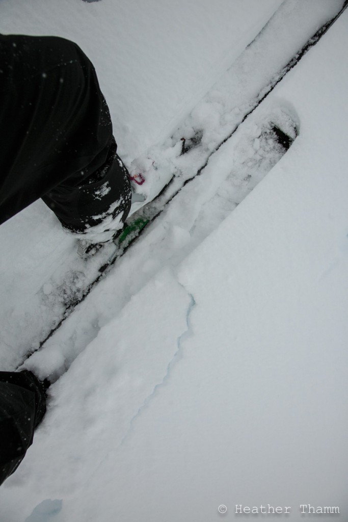
The avalanche danger is CONSIDERABLE above 2000′ where triggering a slab 2-3′ is likely in steep terrain. Cautious route-finding should be used to avoid high consequence terrain features like large open slopes and terrain traps. Remember red flag warnings (recent precipitation, wind loading, warming temperatures, and shooting cracks) were present yesterday and an incoming storm will be adding additional stress to the snowpack today.  

A MODERATE danger rating exists below treeline where an avalanche from above could run into this elevation band in channeled terrain.

Special Announcements

CNFAIC is hosting a Free Avalanche Rescue Workshop on Sunday, December 20th at Turnagain Pass. This is a great opportunity to practice beacon searches, learn strategic shoveling techniques and meet local forecasters! This workshop is open to everyone and anyone, novices and experts.

Thanks to our sponsors!
Fri, December 18th, 2015
Alpine
Above 2,500'
Considerable (3)
Avalanche risk
Treeline
1,000'-2,500'
Considerable (3)
Avalanche risk
Below Treeline
Below 1,000'
Moderate (2)
Avalanche risk
Alpine
Above 2,500'
Avalanche risk
Considerable (3)
Treeline
1,000'-2,500'
Avalanche risk
Considerable (3)
Below Treeline
Below 1,000'
Avalanche risk
Moderate (2)
Danger Scale:
No Rating (0)
Low (1)
Moderate (2)
Considerable (3)
High (4)
Extreme (5)
Avalanche Problem 1
  • Storm Slabs
    Storm Slabs
Storm Slabs
Storm Slab avalanches are the release of a cohesive layer (a slab) of new snow that breaks within new snow or on the old snow surface. Storm-slabs typically last between a few hours and few days (following snowfall). Storm-slabs that form over a persistent weak layer (surface hoar, depth hoar, or near-surface facets) may be termed Persistent Slabs or may develop into Persistent Slabs.
More info at Avalanche.org
  • Dec.17 Storm Totals:
  • Turnagain Pass Center Ridge: 13”
  • Girdwood Midway: 5”
  • Summit Lake: 3”

Yesterday warming temperatures and sustained Northeast winds have left 1-2’ of upside down storm snow in Turnagain Pass. This snow proved tender yesterday and shooting cracks were observed above 2000’ in places where the snow felt stiffened by the wind.  No avalanche activity was reported, but visibility was poor making it difficult to see if any natural avalanche activity occurred.

Today weather conditions will deteriorate again with the arrival of yet another storm that is expected to intensify this evening. Easterly winds will start building this morning along with snow showers by early afternoon. This weather will be adding stress to an already stressed out snowpack. Triggering a slab 2+’ deep will be more likely on unsupported terrain features like steep convex rolls, gullies, and above cliffs. Poor visibility is expected today, but should you choose to travel into the upper elevations, maintain a conservative Jedi mindset. Use stability tests like hand pits or ski pole tests to feel for upside down snow; denser snow sitting on weaker snow. Most of all don’t be tempted by the Dark Side (large open slopes.) Patience you must have!

Shooting cracks observed yesterday on Tincan and a 15″ slab failed easily above the skin track where snow was unsupported.


Avalanche Problem 2
  • Persistent Slabs
    Persistent Slabs
Persistent Slabs
Persistent Slab avalanches are the release of a cohesive layer of snow (a slab) in the middle to upper snowpack, when the bond to an underlying persistent weak layer breaks. Persistent layers include: surface hoar, depth hoar, near-surface facets, or faceted snow. Persistent weak layers can continue to produce avalanches for days, weeks or even months, making them especially dangerous and tricky. As additional snow and wind events build a thicker slab on top of the persistent weak layer, this avalanche problem may develop into a Deep Persistent Slab.
More info at Avalanche.org

We have been tracking several layers of weak snow formed in early December that are now buried under 3-4’ of snow. Poor visibility and dangerous avalanche conditions have made it difficult to evaluate this problem in the upper elevations where a large trigger, like a snowmachine, could find a sweet spot.  This is one of the those low likelihood/high consequence problems that is unlikely to occur naturally and is not manageable.  This is one more reason to avoid large steep slopes until the snowpack can adjust to its new load.   

Weather
Fri, December 18th, 2015

Yesterday a total of 13 € of new snow was recorded at the Turnagain Pass Center Ridge weather station. Sustained moderate winds from the Northeast became light yesterday, but not until most of the snow had already fallen. Temperatures warmed to above freezing, and rain/snow line reached 1200′ by mid afternoon.

Overnight no new precipitation was recorded, winds remained light, and temperatures cooled just below freezing (32F) at sea level.

Today Easterly winds are expected to start building this morning with the arrival of more snow. Snow showers will intensify by this evening and could bring another 1′ of new snow by tomorrow. Temperatures will be hovering around 32F making it possible for rain at sea level.  

*Weather station data is taken from 6am yesterday to 6am today. Yesterday’s storm totals were calculated with the addition of yesterday wx station snow totals.

PRECIPITATION 24-hour data (6am – 6am)

  Temp Avg (F) Snow (in) Water (in) Snow Depth (in)
Center Ridge (1880′) 30F    4 0.4    49
Summit Lake (1400′) 28F   1   0.1   17  
Alyeska Mid (1700′) 31.5F   0   0.03   34  

RIDGETOP 24-hour data (6am – 6am)

  Temp Avg (F) Wind Dir Wind Avg (mph) Wind Gust (mph)
Sunburst (3812′) 24F   NE   11   36  
Seattle Ridge (2400′) 27F   n/a   n/a     n/a    
Observations
Recent Observations for Turnagain Pass
Date Region Location
05/22/23 Turnagain Avalanche: Tincan
05/12/23 Turnagain Avalanche: Tincan, Sunburst, Magnum, Cornbiscuit
05/07/23 Turnagain Observation: Tincan – Bear Tracks
05/05/23 Turnagain Observation: Seattle Ridge
05/02/23 Turnagain Observation: Cornbiscuit
05/02/23 Turnagain Observation: Seward Hwy Turnagain Pass
04/30/23 Turnagain Observation: Magnum
04/29/23 Turnagain Observation: Tincan
04/28/23 Turnagain Avalanche: Taylor Pass/Pastoral
04/28/23 Turnagain Avalanche: Tincan
Riding Areas
Updated Mon, May 15th, 2023

Status of riding areas across the Chugach NF is managed by the Glacier and Seward Ranger Districts, not avalanche center staff. Riding area information is posted as a public service to our users and updated based on snow depth and snow density to prevent resource damage at trailhead locations. Riding area questions contact: mailroom_r10_chugach@fs.fed.us

Area Status Weather & Riding Conditions
Glacier District
Johnson Pass
Closed
Closed May 15.
Placer River
Closed
Closed May 15.
Skookum Drainage
Closed
Will close to motorized use on April 1, 2023 per the National Forest Plan.
Turnagain Pass
Open
Chugach NF staff will be assessing daily after May 15th. Please keep machines on the snow and avoid brown spots to keep this area open as long as possible.
Twentymile
Closed
Scheduled closure May 1.
Seward District
Carter Lake
Closed
Scheduled closure May 1.
Lost Lake Trail
Closed
Scheduled closure May 1.
Primrose Trail
Closed
Scheduled closure May 1.
Resurrection Pass Trail
Closed
Closed to motorized use for the 2022/23 winter season per Forest Plan. Open next season.
Snug Harbor
Closed
Extended opening until May 15.
South Fork Snow River Corridor
Closed
Scheduled closure May 1.
Summit Lake
Closed
Scheduled closure May 1.

Subscribe to Turnagain Pass
Avalanche Forecast by Email

This is a general backcountry avalanche advisory issued for Turnagain Arm with Turnagain Pass as the core advisory area. This advisory does not apply to highways, railroads or operating ski areas.