Turnagain Pass RSS

Archives
ARCHIVED - Forecasts expire after 24 hours.
Issued
Fri, April 3rd, 2015 - 7:00AM
Expires
Sat, April 4th, 2015 - 7:00AM
Forecaster
Heather Thamm
Avalanche risk The Bottom Line

The avalanche danger in the Alpine will increase to CONSIDERABLE today as sunny daytime temperatures climb into the 40’s F. On shaded slopes above 2500′ an already unstable snowpack exists and a slab 2-3′ thick if triggered will have high consequences.  On Sunny aspects as hot daytime temperatures saturate the snowpack triggering a wet avalanche is possible as the snow becomes moist. Today it will be important to avoid steep shaded aspects, as well as steep sun exposed slopes later in the day.

Below 2500′ the avalanche danger is LOW, but  on sunny aspects (South and East facing slopes) the snowpack could become saturated enough to produce wet loose avalanches on steep features.  

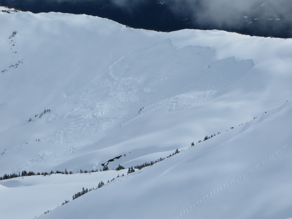
Over the last few days several large skier triggered slab avalanches have occurred on Northern and Western aspects including this avalanche on €œBasketball Chute, € a Northern aspect of Magnum.

Special Announcements

Our new  observations page  is up and running and its easy to use on an iphone. Observations from the field are the backbone of the advisory and help us to provide the most accurate information possible.   Any info is welcome and it doesn’t need to be perfect!   Thanks to everyone that has submitted so far this season.

Fri, April 3rd, 2015
Alpine
Above 2,500'
3 - Considerable
Avalanche risk
Treeline
1,000'-2,500'
1 - Low
Avalanche risk
Below Treeline
Below 1,000'
0 - No Rating
Avalanche risk
0 - No Rating
1 - Low
2 - Moderate
3 - Considerable
4 - High
5 - Extreme
Avalanche risk Avalanche risk Avalanche risk Avalanche risk Avalanche risk
Travel Advice Generally safe avalanche conditions. Watch for unstable snow on isolated terrain features. Heightened avalanche conditions on specific terrain features. Evaluate snow and terrain carefully; identify features of concern. Dangerous avalanche conditions. Careful snowpack evaluation, cautious route-finding, and conservative decision-making essential. Very dangerous avalanche conditions. Travel in avalanche terrain not recommended. Extraordinarily dangerous avalanche conditions. Avoid all avalanche terrain.
Likelihood of Avalanches Natural and human-triggered avalanches unlikely. Natural avalanches unlikely; human-triggered avalanches possible. Natural avalanches possible; human-triggered avalanches likely. Natural avalanches likely; human-triggered avalanches very likely. Natural and human-triggered avalanches certain.
Avalanche Size and Distribution Small avalanches in isolated areas or extreme terrain. Small avalanches in specific areas; or large avalanches in isolated areas. Small avalanches in many areas; or large avalanches in specific areas; or very large avalanches in isolated areas. Large avalanches in many areas; or very large avalanches in specific areas. Very large avalanches in many areas.
Avalanche Problem 1
  • Persistent Slabs
    Persistent Slabs
Persistent Slabs
Persistent Slab avalanches are the release of a cohesive layer of snow (a slab) in the middle to upper snowpack, when the bond to an underlying persistent weak layer breaks. Persistent layers include: surface hoar, depth hoar, near-surface facets, or faceted snow. Persistent weak layers can continue to produce avalanches for days, weeks or even months, making them especially dangerous and tricky. As additional snow and wind events build a thicker slab on top of the persistent weak layer, this avalanche problem may develop into a Deep Persistent Slab.
More info at Avalanche.org

Today very warm daytime temperatures will be contributing stress to an already stressed weak layer that is sitting below a 2-3’ slab on Northern and Western aspects.

Over the last three days several skier triggered slab avalanches have confirmed this problem being widespread throughout Turnagain Pass on shaded slopes above 2500’. Yesterday we investigated a large skier triggered slab avalanche on a Northern aspect of Magnum that happened on April 1st. The slab depth was 2-3’ deep and it ran a total distance of 1300’ to the valley floor. The skier went for a 1000’ ride, but was not buried or injured. We could not access the crown, but dug a pit on a similar aspect and elevation and found several layers of weak faceted snow and crusts beneath a 2.5’ slab.

Obvious signs of instability like collapsing may not be present in the heart of our forecast zone (Tincan, Sunburst, Magnum) and assessing the snowpack on Northern slopes will be difficult to do safely. If an avalanche is triggered today the consequences will likely be high. It will be important to avoid steep Northern and Western aspects above 2500’ until the weak layer(s) have more time to adjust to the load. 

Yesterday a group of skiers on Seattle Ridge felt a collapse and found a large avalanche in Main Bowl in a similar area they had just skinned through. (photo below) It is possible that they triggered it remotely from the Ridge, but it was unwitnessed. It occured between Noon and 1pm as temperature were suddenly rising. This event points to greater instability in this portion of the forecast zone. Photo by John Fitzgerald.

Avalanche Problem 2
  • Wet Loose
    Wet Loose
Wet Loose
Wet Loose avalanches are the release of wet unconsolidated snow or slush. These avalanches typically occur within layers of wet snow near the surface of the snowpack, but they may quickly gouge into lower snowpack layers. Like Loose Dry Avalanches, they start at a point and entrain snow as they move downhill, forming a fan-shaped avalanche. Other names for loose-wet avalanches include point-release avalanches or sluffs. Loose Wet avalanches can trigger slab avalanches that break into deeper snow layers.
More info at Avalanche.org

Over the last three days daytime temperatures have been rapidly increasing around 12pm and today’s hot sunny weather will likely see a similar spike. Springtime conditions exist on predominantly sunny slopes where the snow pack is likely to become saturated throughout the day on Southern and Eastern aspects. If daytime temperature climb into the mid 40’s to 50’s F as forecasted, wet loose and wet slab avalanches will be a concern at all elevations holding snow. 

Additional Concern
  • Cornice
    Cornice
Cornice
Cornice Fall is the release of an overhanging mass of snow that forms as the wind moves snow over a sharp terrain feature, such as a ridge, and deposits snow on the downwind (leeward) side. Cornices range in size from small wind drifts of soft snow to large overhangs of hard snow that are 30 feet (10 meters) or taller. They can break off the terrain suddenly and pull back onto the ridge top and catch people by surprise even on the flat ground above the slope. Even small cornices can have enough mass to be destructive and deadly. Cornice Fall can entrain loose surface snow or trigger slab avalanches.
More info at Avalanche.org

Cornices have grown very large over the last few weeks and with todays warm temperatures natural cornice fall is possible. If traveling along a ridge give cornices a lot of space– they can break farther back than you think.  Adjust your route if you find yourself traveling below a cornice. In the right place (like Seattle Ridge area) a cornice fall could trigger a large slab avalanche. 

Weather
Fri, April 3rd, 2015

Yesterday skies were overcast and in the afternoon and became partly cloudy. Temperatures were very warm, 30-40’s F at mid elevations. Along ridgetops temperatures reached the low 30’s F and winds were light from the Northeast.

Overnight temperatures dipped below freezing along ridgetops, but at mid elevations stayed in the low 30’s F.   Ridgetop winds shifted from the Northeast to the West, but remained light (5-10mph.) An inch of new snow was recorded at Center Ridge Weather Station.

Today very warm and sunny weather is expected.   Daytime temperatures will be warm, 30F – 40F. Near sea level temperature could reach the 50’s F during the warmest part of the day. Winds are expected to be 5-15mph from the North along ridgetops and no precipitation is expected.  

PRECIPITATION 24-hour data (6am – 6am)

  Temp Avg (F) Snow (in) Water (in) Snow Depth (in)
Center Ridge (1880′) 36   1   .01   60  
Summit Lake (1400′) 35   0   0   10  
Alyeska Mid (1700′) 35   0   0   33  

RIDGETOP 24-hour data (6am – 6am)

  Temp Avg (F) Wind Dir Wind Avg (mph) Wind Gust (mph)
Sunburst (3812′) 27   Var.   5   20  
Seattle Ridge (2400′) 30   Var.   3   11  
Observations
Recent Observations for Turnagain Pass
Date Region Location
05/13/24 Turnagain Observation: Eddie’s, Sunburst, Seattle, Cornbiscuit, Pete’s South
05/13/24 Turnagain Observation: Turnagain Pass non-motorized side
05/12/24 Turnagain Observation: Warm up Bowl
05/07/24 Turnagain Observation: Turnagain Pass Wet Slabs
04/29/24 Turnagain Avalanche: Turnagain aerial obs
04/27/24 Turnagain Observation: Johnson Pass
04/23/24 Turnagain Observation: Turnagain Sunny Side
04/21/24 Turnagain Observation: Bertha Creek
04/20/24 Turnagain Avalanche: Spokane Creek
04/16/24 Turnagain Observation: Cornbiscuit
Riding Areas

The riding areas page has moved. Please click here & update your bookmarks.


Subscribe to Turnagain Pass
Avalanche Forecast by Email

This is a general backcountry avalanche advisory issued for Turnagain Arm with Turnagain Pass as the core advisory area. This advisory does not apply to highways, railroads or operating ski areas.