Turnagain Pass Avalanche Forecast RSS

Archives
ARCHIVED FORECAST - All forecasts expire after 24 hours from the posting date/time.
Issued
Thu, April 2nd, 2015 - 7:00AM
Expires
Fri, April 3rd, 2015 - 7:00AM
Forecaster
Graham Predeger
Avalanche risk The Bottom Line

The avalanche danger is MODERATE today above treeline.   Human triggered avalanches 2-3′ deep are possible in isolated areas, particularly North facing terrain.   This looks to be the first day in a week without some measurable precipitation so it’ll be important to let the snowpack continue to adjust to this recent load.   Keep your terrain choices conservative today and as always, practice safe travel protocol when moving through the mountains.

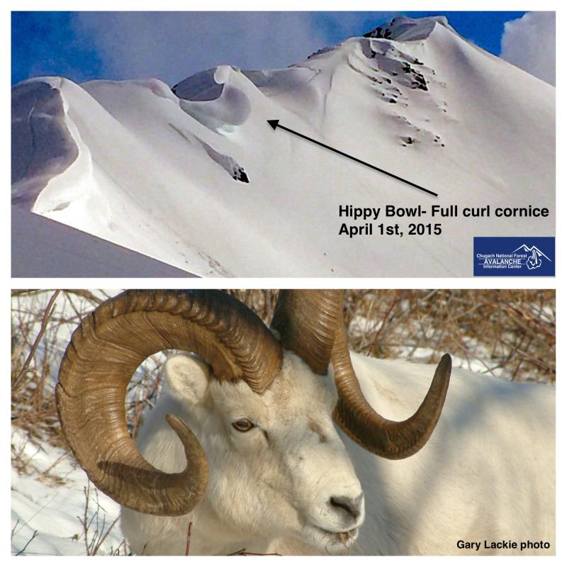
Other concerns today include the impending cornice hazard and wet loose avalanches; both of which may be influenced by a warm Spring day on tap.

Below 2500′, the danger is LOW though potential exists for an avalanche or cornice initiated in the alpine to run into this elevation band.

Thanks to our sponsors!
Thu, April 2nd, 2015
Alpine
Above 2,500'
Moderate (2)
Avalanche risk
Treeline
1,000'-2,500'
Low (1)
Avalanche risk
Below Treeline
Below 1,000'
No Rating (0)
Avalanche risk
Alpine
Above 2,500'
Avalanche risk
Moderate (2)
Treeline
1,000'-2,500'
Avalanche risk
Low (1)
Below Treeline
Below 1,000'
Avalanche risk
No Rating (0)
Danger Scale:
No Rating (0)
Low (1)
Moderate (2)
Considerable (3)
High (4)
Extreme (5)
Avalanche Problem 1
  • Persistent Slabs
    Persistent Slabs
Persistent Slabs
Persistent Slab avalanches are the release of a cohesive layer of snow (a slab) in the middle to upper snowpack, when the bond to an underlying persistent weak layer breaks. Persistent layers include: surface hoar, depth hoar, near-surface facets, or faceted snow. Persistent weak layers can continue to produce avalanches for days, weeks or even months, making them especially dangerous and tricky. As additional snow and wind events build a thicker slab on top of the persistent weak layer, this avalanche problem may develop into a Deep Persistent Slab.
More info at Avalanche.org

Many observations over the last week have pointed toward a strengthening snowpack in the core advisory area.  The exception to this appears to be North aspects above treeline as we’ve had reports of large avalanches in these areas over the last two days; most recently yesterday a skier triggered an avalanche and went for a 1,000’ ride on the north side of Magnum.  Let’s not forget that we have seen 3-5 feet of snow in the alpine (consolidated to 2-3 feet) over the last week that fell on a myriad of different surfaces.  Upper elevation north aspects are notorious for harboring weaker snow longer, which is exactly where surface conditions are best, but also where unstable snow is being found.  Recognize that if an avalanche is initiated, it will likely be big and encompass at least the last week’s storm (2-3’) with the potential to step down deeper. 

As days grow longer (gaining 5 min 44sec today!) and sunnier, the temptation to ski bigger lines and push further out from the road and into periphery areas is strong.  With this, safe travel protocols become increasingly important.  Expose only one person at a time on a slope and utilize good communication and true islands of safety.  

Avalanche Problem 2
  • Cornice
    Cornice
Cornice
Cornice Fall is the release of an overhanging mass of snow that forms as the wind moves snow over a sharp terrain feature, such as a ridge, and deposits snow on the downwind (leeward) side. Cornices range in size from small wind drifts of soft snow to large overhangs of hard snow that are 30 feet (10 meters) or taller. They can break off the terrain suddenly and pull back onto the ridge top and catch people by surprise even on the flat ground above the slope. Even small cornices can have enough mass to be destructive and deadly. Cornice Fall can entrain loose surface snow or trigger slab avalanches.
More info at Avalanche.org

Defying gravity seems an accurate term for some cornices right now.  Given the last seven days of sticky snow and moderate ridgetop winds many of these have grown to full-curl.  Some have failed (Pyramid West face and Todd’s run) but many have only grown closer to the breaking point.  This is a much simpler problem than the aforementioned persistent slab because we can see cornices; and what we can see, we can avoid.  Simply minimize time spent underneath and give these backcountry bombs an extra wide berth when travelling on ridgelines.  

Hippy bowl ridge and large, curling cornice.

Additional Concern
  • Dry Loose
    Dry Loose
Dry Loose
Dry Loose avalanches are the release of dry unconsolidated snow and typically occur within layers of soft snow near the surface of the snowpack. These avalanches start at a point and entrain snow as they move downhill, forming a fan-shaped avalanche. Other names for loose-dry avalanches include point-release avalanches or sluffs.
More info at Avalanche.org

Daytime heating and light winds could be concern for wet loose avalanches on steep south and west facing slopes today.  Generally slow moving, these are a different beast than a slab avalanche.  Wet loose activity is generally of concern if the potential exists to push you off your skis and into a terrain trap.

Weather
Thu, April 2nd, 2015

Yesterday morning started out with an intense band of snow moving through Turnagain pass depositing a quick 2-4 € at the road.   Temperatures warmed throughout the day and intermittent periods of sun through broken clouds proved enough to melt that little bit of accumulation by 5pm.   On ridgetops, temps were in the mid 20’s, winds light to moderate from the northeast and intermittent snow showers added up to 3-5 € (above 2,000′) on the northern side of Turnagain pass.

Today looks to be the start of a clearing trend that will last through the weekend with no precipitation forecasted.   Expect temps to be warm today (mid-30’s at 3,000′) and wind shifting to the north in the 10-20mph range as an outflow (off shore winds) regime sets up.   Slightly cooler air will filter in tomorrow and through the weekend under clear skies.

PRECIPITATION 24-hour data (6am – 6am)

  Temp Avg (F) Snow (in) Water (in) Snow Depth (in)
Center Ridge (1880′) 32   2  .2 59  
Summit Lake (1400′)  35  0  .04  10
Alyeska Mid (1700′)  33  2  .15  36

RIDGETOP 24-hour data (6am – 6am)

  Temp Avg (F) Wind Dir Wind Avg (mph) Wind Gust (mph)
Sunburst (3812′) 23    ENE 11   38  
Seattle Ridge (2400′) 26    n/a 10   29  
Observations
Recent Observations for Turnagain Pass
Date Region Location
05/22/23 Turnagain Avalanche: Tincan
05/12/23 Turnagain Avalanche: Tincan, Sunburst, Magnum, Cornbiscuit
05/07/23 Turnagain Observation: Tincan – Bear Tracks
05/05/23 Turnagain Observation: Seattle Ridge
05/02/23 Turnagain Observation: Cornbiscuit
05/02/23 Turnagain Observation: Seward Hwy Turnagain Pass
04/30/23 Turnagain Observation: Magnum
04/29/23 Turnagain Observation: Tincan
04/28/23 Turnagain Avalanche: Taylor Pass/Pastoral
04/28/23 Turnagain Avalanche: Tincan
Riding Areas
Updated Thu, June 01st, 2023

Status of riding areas across the Chugach NF is managed by the Glacier and Seward Ranger Districts, not avalanche center staff. Riding area information is posted as a public service to our users and updated based on snow depth and snow density to prevent resource damage at trailhead locations. Riding area questions contact: mailroom_r10_chugach@fs.fed.us

Area Status Weather & Riding Conditions
Glacier District
Johnson Pass
Closed
Closed May 15.
Placer River
Closed
Closed May 15.
Skookum Drainage
Closed
Will close to motorized use on April 1, 2023 per the National Forest Plan.
Turnagain Pass
Closed
Will close on June 1.
Twentymile
Closed
Scheduled closure May 1.
Seward District
Carter Lake
Closed
Scheduled closure May 1.
Lost Lake Trail
Closed
Scheduled closure May 1.
Primrose Trail
Closed
Scheduled closure May 1.
Resurrection Pass Trail
Closed
Closed to motorized use for the 2022/23 winter season per Forest Plan. Open next season.
Snug Harbor
Closed
Extended opening until May 15.
South Fork Snow River Corridor
Closed
Scheduled closure May 1.
Summit Lake
Closed
Scheduled closure May 1.

Subscribe to Turnagain Pass
Avalanche Forecast by Email

This is a general backcountry avalanche advisory issued for Turnagain Arm with Turnagain Pass as the core advisory area. This advisory does not apply to highways, railroads or operating ski areas.